Municipal District of Ranchland No. 66
The Municipal District of Ranchland No. 66 is a municipal district in southwest Alberta, Canada. Containing no urban communities of any kind, its municipal office is located in Chain Lakes Provincial Park,[3] approximately 38 km (24 mi) southwest of the Town of Nanton. Ranchland's rugged foothill terrain is unsuited for the crop agriculture practiced elsewhere in Alberta, and ranching remains the single livelihood of its inhabitants. With a 2016 population of 92, it is the least populated municipal district in Alberta, and its population density of 29 square kilometres for every resident is almost exactly equal to that of the Northwest Territories.
Ranchland No. 66 | |
|---|---|
Municipal district | |
| Municipal District of Ranchland No. 66 | |
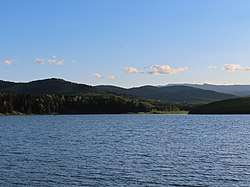 Foothills at Chain Lakes | |
Logo 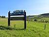 Welcome sign | |
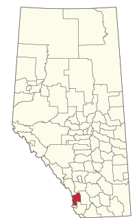 Location within Alberta | |
| Country | Canada |
| Province | Alberta |
| Region | Southern Alberta |
| Planning region | South Saskatchewan |
| Established | 1995 |
| Incorporated | 1995 |
| Government | |
| • Reeve | Cameron Gardner |
| • Governing body | M.D. of Ranchland Council |
| • Office location | Chain Lakes Provincial Park |
| Area (2016)[2] | |
| • Land | 2,638.7 km2 (1,018.8 sq mi) |
| Population (2016)[2] | |
| • Total | 92 |
| • Density | 0.035/km2 (0.09/sq mi) |
| Time zone | UTC-7 (MST) |
| Website | mdranchland.ca |
History
The municipal district was incorporated in 1995 from the Improvement District No. 6.
Demographics
| Federal census population history | ||
|---|---|---|
| Year | Pop. | ±% |
| 1971 | 133 | — |
| 1976 | 110 | −17.3% |
| 1981 | 119 | +8.2% |
| 1986 | 128 | +7.6% |
| 1991 | 130 | +1.6% |
| 1996 | 108 | −16.9% |
| 2001 | 96 | −11.1% |
| 2006 | 86 | −10.4% |
| 2011 | 79 | −8.1% |
| 2016 | 92 | +16.5% |
| Source: Statistics Canada [4][5][6][7][8][9] | ||
In the 2016 Census of Population conducted by Statistics Canada, the Municipal District of Ranchland No. 66 recorded a population of 92 living in 38 of its 57 total private dwellings, a 16.5% change from its 2011 population of 79. With a land area of 2,638.7 km2 (1,018.8 sq mi), it had a population density of 0.0/km2 (0.1/sq mi) in 2016.[2]
The Municipal District of Ranchland No. 66's 2013 municipal census counted a population of 104.[10]
In the 2011 Census, the Municipal District of Ranchland No. 66 had a population of 79 living in 31 of its 45 total dwellings, a -8.1% change from its 2006 population of 86. With a land area of 2,639.16 km2 (1,018.99 sq mi), it had a population density of 0.0/km2 (0.1/sq mi) in 2011.[11]
Communities
There are no communities located within the Municipal District of Ranchland No. 66.[12]
See also
- List of communities in Alberta
- List of municipal districts in Alberta
- Rural Municipality of Glen McPherson No. 46 - the least-populated county-equivalent municipality in Canada, with 72 residents in 2016
References
- "Municipal Officials Search". Alberta Municipal Affairs. September 22, 2017. Retrieved September 25, 2017.
- "Population and dwelling counts, for Canada, provinces and territories, and census subdivisions (municipalities), 2016 and 2011 censuses – 100% data (Alberta)". Statistics Canada. February 8, 2017. Retrieved February 8, 2017.
- "Directions to MD Ranchland Administration building" (PDF). Municipal District of Ranchland No. 66. Retrieved 2012-03-26.
- "Table 3: Population for census divisions and subdivisions, 1971 and 1976". 1976 Census of Canada. Census Divisions and Subdivisions, Western Provinces and the Territories. Population: Geographic Distributions. Ottawa: Statistics Canada. 1977.
- "Table 2: Census Subdivisions in Alphabetical Order, Showing Population Rank, Canada, 1981". 1981 Census of Canada. Census subdivisions in decreasing population order. Ottawa: Statistics Canada. 1982. ISBN 0-660-51563-6.
- "Table 2: Population and Dwelling Counts, for Census Divisions and Census Subdivisions, 1986 and 1991 – 100% Data". 91 Census. Population and Dwelling Counts – Census Divisions and Census Subdivisions. Ottawa: Statistics Canada. 1992. pp. 100–108. ISBN 0-660-57115-3.
- "Population and Dwelling Counts, for Canada, Provinces and Territories, and Census Divisions, 2001 and 1996 Censuses – 100% Data (Alberta)". Statistics Canada. Retrieved 2019-05-28.
- "Population and dwelling counts, for Canada, provinces and territories, and census subdivisions (municipalities), 2006 and 2001 censuses – 100% data (Alberta)". Statistics Canada. January 6, 2010. Retrieved 2019-05-28.
- "Census Profile, 2016 Census". Statistics Canada. February 8, 2017. Retrieved 2019-05-28.
- "2013 Municipal Affairs Population List" (PDF) (PDF). Alberta Municipal Affairs. November 20, 2013. ISBN 978-1-4601-1418-6. Retrieved December 5, 2013.
- "Population and dwelling counts, for Canada, provinces and territories, and census subdivisions (municipalities), 2011 and 2006 censuses (Alberta)". Statistics Canada. February 8, 2012. Retrieved February 8, 2012.
- "Specialized and Rural Municipalities and Their Communities" (PDF). Alberta Municipal Affairs. 2012-03-01. Archived from the original (PDF) on 2012-04-09. Retrieved 2012-08-12.
External links
Places adjacent to Municipal District of Ranchland No. 66 | ||||||||||
|---|---|---|---|---|---|---|---|---|---|---|
| ||||||||||
| Subdivisions | |
|---|---|
| Communities | |
| Cities and urban service areas | |
| Rural municipalities | |
| Specialized municipalities | |
| |