Mackenzie County
Mackenzie County is a specialized municipality in northern Alberta, Canada. It is located in Census Division 17, along the Mackenzie Highway. Incorporated as a municipal district in 1995 from the former Improvement District No. 23., its status was changed to specialized municipality in 1999 to address the particularities of managing such a large territory, which is 10% larger than New Brunswick. Mackenzie County municipal office is located in the Hamlet of Fort Vermilion. The name was changed from the Municipal District of Mackenzie No. 23 (=Mackenzie M. D.) to Mackenzie County in 2007.[1]
Mackenzie County | |
|---|---|
Specialized municipality | |
 Boundary sign | |
 | |
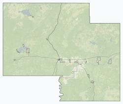
 Location within Alberta | |
| Country | Canada |
| Province | Alberta |
| Region | Northern Alberta |
| Planning region | Lower Peace |
| Incorporated [1] - Municipal district | January 1, 1995 |
| - Specialized municipality | June 23, 1999 |
| Name change [1] | March 8, 2007 |
| Government | |
| • Reeve | Josh Knelsen[3] |
| • Governing body | Mackenzie County Council
|
| • CAO | Lenard Racher |
| • Office location | Fort Vermilion |
| Area (2016)[4] | |
| • Land | 80,458.19 km2 (31,065.08 sq mi) |
| Population (2016)[4] | |
| • Total | 11,171 |
| • Density | 0.1/km2 (0.3/sq mi) |
| • Municipal census (2018) | 12,514 |
| Time zone | UTC−7 (MST) |
| • Summer (DST) | UTC−6 (MDT) |
| Website | mackenziecounty.com |
Demographics
The population of Mackenzie County according to its 2018 municipal census is 12,514,[8] a change of 6.5% from its 2015 municipal census population of 11,750.[9]
In the 2016 Census of Population conducted by Statistics Canada, Mackenzie County recorded a population of 11,171 living in 3,088 of its 3,567 total private dwellings, a change of 2.2% from its 2011 population of 10,927. With a land area of 80,458.19 km2 (31,065.08 sq mi), it had a population density of 0.1/km2 (0.4/sq mi) in 2016.[4]
In the 2011 Census, Mackenzie County had a population of 10,927 living in 2,900 of its 3,123 total dwellings, a change of 9.2% from its 2006 population of 10,002. With a land area of 80,478.12 km2 (31,072.78 sq mi), it had a population density of 0.1/km2 (0.4/sq mi) in 2011.[7]
Communities and localities
- Cities
- none
- Towns
- High Level
- Rainbow Lake
- Villages
- none
- Summer villages
- none
The following hamlets are located within Mackenzie County.[10]
The following localities are located within Mackenzie County.[11]
- Localities
- Adams Landing
- Assumption
- Boyer
- Boyer River Settlement
- Boyer Settlement
- Buffalo Head Prairie
- Carcajou Settlement
- Chateh
- Footner Lake
- Fort Vermilion Settlement
- Habay
- Hutch Lake
- Indian Cabins
- Little Red River
- Lutose
- Meander River
- Meander River Station
- Metis
- North Vermilion
- North Vermilion Settlement
- Slavey Creek
- Steen River
- Vermilion Chutes
Gallery
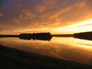 Peace River in Fort Vermilion
See also
- List of communities in Alberta
- Specialized municipalities of Alberta
References
- Alberta Municipal Affairs (2010-09-17). "Municipal Profile – Mackenzie County". Retrieved 2010-10-02.
- "Municipal Officials Search". Alberta Municipal Affairs. September 22, 2017. Retrieved September 25, 2017.
- "Councillors". www.mackenziecounty.com. Retrieved 2019-06-14.
- "Population and dwelling counts, for Canada, provinces and territories, and census subdivisions (municipalities), 2016 and 2011 censuses – 100% data (Alberta)". Statistics Canada. February 8, 2017. Retrieved February 8, 2017.
- "Community Highlights for Mackenzie No. 23". Statistics Canada. August 26, 2013. Retrieved September 11, 2015.
- "Canada 2006 Census: Mackenzie No. 23 - Community Profile". Statistics Canada. Retrieved June 11, 2007.
- "Population and dwelling counts, for Canada, provinces and territories, and census subdivisions (municipalities), 2011 and 2006 censuses (Alberta)". Statistics Canada. February 8, 2012. Retrieved February 8, 2012.
- "2018 Municipal Affairs Population List" (PDF). Alberta Municipal Affairs. December 2018. ISBN 978-1-4601-4254-7. Retrieved December 20, 2018.
- "Request for Decision: 2015 Census Results" (PDF). Mackenzie County. August 26, 2015. Retrieved August 21, 2015.
- "Specialized and Rural Municipalities and Their Communities" (PDF). Alberta Municipal Affairs. 2012-03-01. Archived from the original (PDF) on 2012-04-09. Retrieved 2012-08-11.
- "Standard Geographical Classification (SGC) 2006, Economic Regions: 4817095 - Mackenzie No. 23, geographical codes and localities, 2006". Statistics Canada. 2010-03-05. Retrieved 2012-08-11.
External links
Places adjacent to Mackenzie County | |
|---|---|
| Subdivisions | |
|---|---|
| Communities | |
| Cities and urban service areas | |
| Rural municipalities | |
| Specialized municipalities | |
| |
| Towns | |
|---|---|
| Hamlets |
|
| Métis settlements | |
| Municipal districts | |
| Specialized municipalities |
|
| Improvement districts |
|
| Indian reserves |
|
| National parks | |
| Provincial parks | |
| Other topics |
|