Wasatch County, Utah
Wasatch County (/ˈwɑːsætʃ/ WAH-satch) is a county in the U.S. state of Utah. As of the 2010 United States Census, the population was 23,530.[1] Its county seat and largest city is Heber City.[2] The county was named for a Ute Indian word meaning mountain pass or low place in the high mountains.
Wasatch County | |
|---|---|
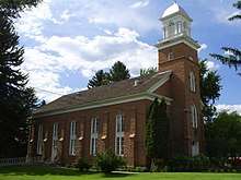 Wasatch Stake Tabernacle in Heber City. | |
 Seal | |
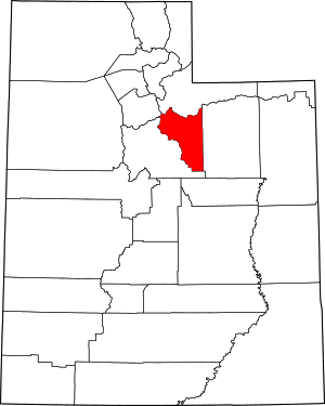 Location within the U.S. state of Utah | |
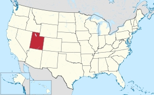 Utah's location within the U.S. | |
| Coordinates: 40°20′N 111°10′W | |
| Country | |
| State | |
| Founded | 1862 |
| Named for | Ute word for mountain pass |
| Seat | Heber City |
| Largest city | Heber City |
| Area | |
| • Total | 1,206 sq mi (3,120 km2) |
| • Land | 1,176 sq mi (3,050 km2) |
| • Water | 30 sq mi (80 km2) 2.5% |
| Population (2010) | |
| • Total | 23,530 |
| • Estimate (2019) | 34,091 |
| • Density | 29/sq mi (11/km2) |
| Time zone | UTC−7 (Mountain) |
| • Summer (DST) | UTC−6 (MDT) |
| Congressional district | 3rd |
| Website | www |
Wasatch County is part of the Heber, UT Micropolitan Statistical Area as well as the Salt Lake City-Provo-Orem, UT Combined Statistical Area.
History
The first settlers were Mormon pioneers, in 1859, settling near present Heber City, Midway, and Charleston. On January 17, 1862 the Utah Territory legislature created the county, annexing areas from Great Salt Lake, Green River, Sanpete, Summit, and Utah counties. Heber was selected as the county seat. Wasatch in Ute means "mountain pass" or "low pass over high range". Heber City was named for Mormon Apostle Heber C. Kimball. The county boundaries were altered in 1880 and 1884, and then on January 4, 1915 the eastern portion was partitioned off to become Duchesne County. The Wasatch County boundaries have remained unchanged since 1915.[3]
Geography
Heber Valley has relatively cool climate, since it is mountain-ringed, and over half the land is 7,500 feet above sea level. The average annual precipitation is about 16 inches. The county is divided into two watersheds—the Colorado and the Great Basin drainage systems.[4] Flowing from the East are Daniels, Lake Fork, and Center creeks. From the north and northeast is the Provo River. Flowing from the west is Snake Creek. The county's highest point is the west slope of Murdock Mountain[4] in the Uinta Mountains, at 10,840' (3304m) ASL.[5]
Wasatch County has a total area of 1,206 square miles (3,120 km2), of which 1,176 square miles (3,050 km2) is land and 30 square miles (78 km2) (2.5%) is water.[6]
Major highways
- United States Highway US-6
- United States Highway US-40
- United States Highway US-189
- Utah State Highway UT-32
- Utah State Highway UT-35
- Utah State Highway UT-113
- Utah State Highway UT-248
- Utah State Highway UT-319[4]
Adjacent counties
- Salt Lake County - northwest
- Summit County - north
- Duchesne County - east
- Utah County - southwest
Protected areas
- Ashley National Forest (part)
- Currant Creek Campground (USFS)
- Currant Creek Wildlife Management Area (part)
- Deer Creek State Park
- Rock Cliff Campground (Utah State Park)
- Soldier Creek Recreational Area
- Uinta National Forest (part)
- Wasatch Mountain State Park
- Wasatch National Forest (part)
- Wildcat Mountain Wildlife Management Area[4]
Lakes
- Currant Creek Reservoir
- Deer Creek Reservoir
- Jordanelle Reservoir
- Strawberry Reservoir
- Witts Lake[4]
Demographics
| Historical population | |||
|---|---|---|---|
| Census | Pop. | %± | |
| 1870 | 1,244 | — | |
| 1880 | 2,927 | 135.3% | |
| 1890 | 3,595 | 22.8% | |
| 1900 | 4,786 | 33.1% | |
| 1910 | 8,920 | 86.4% | |
| 1920 | 4,625 | −48.2% | |
| 1930 | 5,636 | 21.9% | |
| 1940 | 5,754 | 2.1% | |
| 1950 | 5,574 | −3.1% | |
| 1960 | 5,308 | −4.8% | |
| 1970 | 5,863 | 10.5% | |
| 1980 | 8,523 | 45.4% | |
| 1990 | 10,089 | 18.4% | |
| 2000 | 15,215 | 50.8% | |
| 2010 | 23,530 | 54.7% | |
| Est. 2019 | 34,091 | 44.9% | |
| US Decennial Census[7] 1790–1960[8] 1900–1990[9] 1990–2000[10] 2010–2018[1] 2019[11] | |||
2010 census
As of the 2010 United States Census, there were 23,530 people, 4,743 households, and 3,870 families in the county. The population density was 20.0/sqmi (7.73/km²). There were 9,840 (2009) housing units at an average density of 8.37/sqmi (3.23/km²). The racial makeup of the county was 90.4% White, 0.3% Black or African American, 0.5% Native American, 0.8% Asian, 0.1% Pacific Islander, and 1.4% from two or more races. 13.5% of the population were Hispanic or Latino of any race.
There were 7,287 households out of which 43.1% had children under the age of 18 living with them, 68.70% were married couples living together, 7.4% had a female householder with no husband present, 3.8% had a male householder with no wife present, and 20.1% were non-families. 15.5% of all households were made up of individuals and 4.8% had someone living alone who was 65 years of age or older. The average household size was 3.18 and the average family size was 3.19.
The county population contained 36.3% under the age of 20, 5.2% from 20 to 24, 28.1% from 25 to 44, 21.9% from 45 to 64, and 8.6% who were 65 years of age or older. The median age was 31.6 years. For every 100 females there were 103.40 males. For every 100 females age 18 and over, there were 101.5 males.
2000 census
As of the 2000 United States Census, the median income for a household in the county was $49,612, and the median income for a family was $52,102. Males had a median income of $37,399 versus $23,571 for females. The per capita income for the county was $19,869. About 4.20% of families and 5.20% of the population were below the poverty line, including 5.60% of those under age 18 and 4.00% of those age 65 or over.
Communities
Cities
- Heber City (county seat)
- Midway
Unincorporated communities
- Center Creek
- Deer Mountain
- Mayflower
- Soldier Summit
- Wildwood (part)
Former communities
Government and politics
The county is governed by a seven-member county council with an appointed county manager.[12] as of 2019 County Council members are Chairman Danny Goode, Vice-chairman Mark Nelson, Kendall Crittenden, Steve Farrell, Spencer Park, Jeff Wade, and Marlyn Crittenden.[13] Mike Davis is the appointed County Manager.
Wasatch County has traditionally voted Republican. In no national election since 1964 has the county selected the Democratic Party candidate (as of 2016).
| Year | Republican | Democratic | Third parties |
|---|---|---|---|
| 2016 | 49.9% 6,115 | 25.0% 3,063 | 25.2% 3,088 |
| 2012 | 74.9% 7,220 | 22.7% 2,191 | 2.4% 229 |
| 2008 | 63.0% 5,430 | 33.5% 2,892 | 3.5% 303 |
| 2004 | 73.3% 5,503 | 24.7% 1,854 | 2.1% 155 |
| 2000 | 67.3% 3,819 | 26.0% 1,476 | 6.7% 380 |
| 1996 | 52.4% 2,222 | 32.4% 1,374 | 15.2% 646 |
| 1992 | 42.0% 1,822 | 24.0% 1,042 | 34.0% 1,472 |
| 1988 | 62.2% 2,487 | 36.3% 1,451 | 1.5% 59 |
| 1984 | 72.9% 2,789 | 26.5% 1,015 | 0.5% 20 |
| 1980 | 70.9% 2,799 | 25.2% 994 | 3.9% 153 |
| 1976 | 61.6% 1,940 | 34.7% 1,092 | 3.8% 118 |
| 1972 | 70.2% 2,046 | 23.8% 693 | 6.0% 175 |
| 1968 | 61.0% 1,611 | 35.6% 941 | 3.4% 91 |
| 1964 | 44.9% 1,158 | 55.1% 1,420 | |
| 1960 | 58.1% 1,480 | 41.9% 1,066 | 0.0% 1 |
| 1956 | 66.8% 1,738 | 33.2% 864 | |
| 1952 | 63.4% 1,677 | 36.6% 968 | |
| 1948 | 48.8% 1,165 | 51.0% 1,219 | 0.2% 5 |
| 1944 | 45.8% 1,058 | 54.1% 1,249 | 0.1% 2 |
| 1940 | 44.4% 1,199 | 55.6% 1,502 | 0.0% 1 |
| 1936 | 44.1% 1,029 | 55.7% 1,299 | 0.3% 6 |
| 1932 | 48.2% 1,042 | 51.0% 1,103 | 0.8% 18 |
| 1928 | 57.8% 1,340 | 42.0% 973 | 0.2% 4 |
| 1924 | 52.4% 1,105 | 34.5% 727 | 13.1% 277 |
| 1920 | 61.1% 1,061 | 38.3% 665 | 0.7% 12 |
| 1916 | 47.6% 817 | 51.6% 885 | 0.8% 14 |
| 1912 | 41.7% 1,210 | 33.0% 957 | 25.3% 734 |
| 1908 | 53.8% 1,265 | 41.9% 985 | 4.3% 100 |
| 1904 | 60.8% 1,042 | 38.3% 656 | 0.9% 16 |
| 1900 | 47.9% 723 | 51.8% 781 | 0.3% 5 |
| 1896 | 3.7% 51 | 96.3% 1,333 |
References
- "State & County QuickFacts". United States Census Bureau. Retrieved December 30, 2013.
- "Find a County". National Association of Counties. Retrieved June 7, 2011.
- Individual County Chronologies/Wasatch County UT. Newberry Library (accessed April 1, 2019)
- Wasatch County UT Google Maps (accessed 1 April 2019)
- Utah County High Points/Wasatch County. Peakbagger (accessed 1 April 2019)
- "2010 Census Gazetteer Files". US Census Bureau. August 22, 2012. Retrieved June 26, 2015.
- "US Decennial Census". US Census Bureau. Retrieved June 26, 2015.
- "Historical Census Browser". University of Virginia Library. Retrieved June 26, 2015.
- Forstall, Richard L., ed. (March 27, 1995). "Population of Counties by Decennial Census: 1900 to 1990". US Census Bureau. Retrieved June 26, 2015.
- "Census 2000 PHC-T-4. Ranking Tables for Counties: 1990 and 2000" (PDF). US Census Bureau. April 2, 2001. Retrieved June 26, 2015.
- "QuickFacts. Utah counties". Retrieved May 17, 2020.
- "Wasatch County Administrative Services". Archived from the original on September 30, 2011. Retrieved October 17, 2011.
- "Wasatch County Government - County Council". www.wasatch.utah.gov. Retrieved May 23, 2016.
- Leip, David. "Atlas of US Presidential Elections". uselectionatlas.org. Retrieved March 31, 2018.
External links
| Wikimedia Commons has media related to Wasatch County, Utah. |
Places adjacent to Wasatch County, Utah | ||||||||||
|---|---|---|---|---|---|---|---|---|---|---|
| ||||||||||
Municipalities and communities of Wasatch County, Utah, United States | ||
|---|---|---|
| Cities | Map of Utah highlighting Wasatch County | |
| Towns | ||
| CDP | ||
| Indian reservation | ||
| Ghost towns | ||
| Footnotes | ‡This populated place also has portions in an adjacent county or counties | |
Salt Lake City (capital) | |||||||||||||
| Topics |
|  | |||||||||||
| Society |
| ||||||||||||
| Regions | |||||||||||||
| Largest cities |
| ||||||||||||
| Counties | |||||||||||||
| Attractions |
| ||||||||||||
| Authority control |
|
|---|