Millard County, Utah
Millard County (/ˈmɪlərd/ MIL-ərd) is a county in the U.S. state of Utah. As of the 2010 United States Census, the population was 12,503.[1] Its county seat is Fillmore,[2] and the largest city is Delta.
Millard County | |
|---|---|
 Old Millard County courthouse | |
 Location within the U.S. state of Utah | |
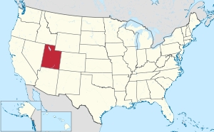 Utah's location within the U.S. | |
| Coordinates: 39°03′N 113°06′W | |
| Country | |
| State | |
| Founded | October 4, 1851 |
| Named for | Millard Fillmore |
| Seat | Fillmore |
| Largest city | Delta |
| Area | |
| • Total | 6,828 sq mi (17,680 km2) |
| • Land | 6,572 sq mi (17,020 km2) |
| • Water | 255 sq mi (660 km2) 3.7% |
| Population (2010) | |
| • Total | 12,503 |
| • Estimate (2019) | 13,188 |
| • Density | 2/sq mi (0.8/km2) |
| Time zone | UTC−7 (Mountain) |
| • Summer (DST) | UTC−6 (MDT) |
| Congressional district | 2nd |
| Website | www |
History
The Utah Territory legislature created the county on October 4, 1851, with territory not previously covered by county creations, and including some area in the future state of Nevada. It was named for thirteenth US President Millard Fillmore, who was in office at the time.[3] Fillmore was designated as the county seat. The county boundaries were altered in 1852, in 1854, in 1861, and in January 1862. In July 1862, the US government created the Nevada Territory, which effectively de-annexed the described portion of Millard County falling in that Territorial Proclamation. The county boundary was further altered in 1866, in 1888, and in 1919. In 1921 a boundary adjustment with Sevier brought Millard to its present configuration.[4]
Fillmore, located near the geographic center of the territory, was originally built as the capital of Utah Territory. The Utah Territorial Legislature approved a plan to locate the capital in the Pahvant Valley. On October 28, 1851, Utah Governor Brigham Young traveled to the valley and chose the specific site for Fillmore. The town was surveyed that same day. A colonizing company soon followed; they built houses, a grist mill, and a sawmill. Construction of the State Capitol was initiated in 1852. The Territorial legislature met in Fillmore for the first (and only time) in 1855. The following year they voted to keep the capitol in Great Salt Lake City.[5]
Geography
Millard County lies on the west side of Utah. Its west border abuts the east border of the state of Nevada. The county terrain consists of arid, rough undulating flatlands interrupted by numerous hills and mountain ridges.[6] The highest point in the county is Mine Camp Peak in the Central Utah Plateaus, at 10,222' (3116m) ASL.[7] The county has a total area of 6,828 square miles (17,680 km2), of which 6,572 square miles (17,020 km2) is land and 255 square miles (660 km2) (3.7%) is water.[8] It is the third-largest county in Utah by area.
The Sevier Desert covers much of Millard County, being the seafloor of ancient Lake Bonneville. Sevier Lake, a mostly dry remnant of Lake Bonneville, is in central Millard County. The Pahvant Mountains form the county's eastern boundary. Fillmore and other farming communities lie at the base of the Pahvant Mountains. Delta sits several miles from the banks of the Sevier River in the middle of the basin.
Major highways[6]
- US Interstate I - 15
- US Interstate I - 70
- US-6
- US-50
- Utah State U-21
- Utah State U-100
- Utah State U-125
- Utah State U-132
- Utah State U-133
- Utah State U-136
- Utah State U-257
Adjacent counties
- Juab County - north
- Sanpete County - northeast
- Sevier County - southeast
- Beaver County - south
- Lincoln County, Nevada - southwest
- White Pine County, Nevada - west
Protected areas[6]
- Circus Hollow Wildlife Management Area
- Clear Lake Waterfowl Management Area
- Fishlake National Forest (part)
- Halfway Hill Wildlife Management Area
Lakes[6]
- Clear Lake
- Pruess Lake
- Scipio Lake
- Sevier Lake
Great Stone Face
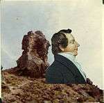
Pahvant Valley in Millard County has several ancient lava flows and extinct volcanoes, including the "Black Rock" lava flow. About 17 miles (27 km) southwest of Delta, near Black Rock's northwest perimeter is a feature named the "Great Stone Face", which protrudes about four stories above the general elevation.[9] Locals claim that this rock formation, when viewed at the correct angle, appears similar to a profile of Joseph Smith.[10][11] At ground level, within view of the "Great Stone Face", is a large, smooth-faced rock covered in Native American petroglyphs.
Notch Peak
Notch Peak is 50 miles (80 km) west of Delta. The skyline appears to have a notch taken out of it when viewed from Delta.
Little Sahara Sand Dunes
Little Sahara Recreation Area, 25 miles (40 km) north of Delta, is a popular area for ATV riders.[12]
Demographics
| Historical population | |||
|---|---|---|---|
| Census | Pop. | %± | |
| 1860 | 715 | — | |
| 1870 | 2,753 | 285.0% | |
| 1880 | 3,727 | 35.4% | |
| 1890 | 4,033 | 8.2% | |
| 1900 | 5,678 | 40.8% | |
| 1910 | 6,118 | 7.7% | |
| 1920 | 9,659 | 57.9% | |
| 1930 | 9,945 | 3.0% | |
| 1940 | 9,613 | −3.3% | |
| 1950 | 9,387 | −2.4% | |
| 1960 | 7,866 | −16.2% | |
| 1970 | 6,988 | −11.2% | |
| 1980 | 8,970 | 28.4% | |
| 1990 | 11,333 | 26.3% | |
| 2000 | 12,405 | 9.5% | |
| 2010 | 12,503 | 0.8% | |
| Est. 2019 | 13,188 | 5.5% | |
| US Decennial Census[13] 1790–1960[14] 1900–1990[15] 1990–2000[16] 2010–2018[1] 2019[17] | |||
As of the 2000 United States Census, there were 12,405 people, 3,840 households, and 3,091 families in the county. The population density was 1.89/sqmi (0.73/km²). There were 4,522 housing units at an average density of 0.69/sqmi (0.27/km²). In 2000 there were 3,840 households out of which 46.10% had children under the age of 18 living with them, 70.60% were married couples living together, 7.10% had a female householder with no husband present, and 19.50% were non-families. 18.30% of all households were made up of individuals and 10.10% had someone living alone who was 65 years of age or older. The average household size was 3.19 and the average family size was 3.66.
The county population contained 37.30% under the age of 18, 8.00% from 18 to 24, 22.90% from 25 to 44, 19.40% from 45 to 64, and 12.30% who were 65 years of age or older. The median age was 30 years. For every 100 females there were 104.90 males. For every 100 females age 18 and over, there were 101.90 males.
The median income for a household in the county was $36,178, and the median income for a family was $41,797. Males had a median income of $36,989 versus $20,168 for females. The per capita income for the county was $13,408. About 9.40% of families and 13.10% of the population were below the poverty line, including 17.20% of those under age 18 and 7.20% of those age 65 or over.
The 2000 Census reported the racial makeup of the county was 93.94% White, 0.10% Black or African American, 1.31% Native American, 0.48% Asian, 0.20% Pacific Islander, 2.76% from other races, and 1.21% from two or more races. 7.18% of the population were Hispanic or Latino of any race.
By 2005, 86.7% of Millard County's population was non-Hispanic whites. The proportion of African Americans had doubled to 0.2%. Native Americans were now 1.5% of the county's population. Asians had fallen to only 0.4% of the population. 11.0% of the population was Latino, just above the 10.9% for Utah as a whole.[18]
As of 2010 Millard County had a population of 12,310. The ethnic and racial makeup of the population was 84.7% non-Hispanic white, 0.1% black, 1.0% Native American, 0.6% Asian, 0.1% Pacific Islander, 1.5% reporting two or more races and 12.8% Hispanic or Latino.[19]
Economy
One element of Millard County's economy is the digging of fossils. Trilobite fossils are relatively common in the region west of Delta (part of the Wheeler Shale of Middle Cambrian age).
15% of Millard county's economy is from farming.
Millard County is working hard to make it easier to build Earthships, straw bale homes, and other ecological and sustainable housing.
Millard County is the home of the Telescope Array Project ultra-high-energy cosmic ray observatory.
Japanese internment camp
The Topaz War Relocation Center was a World War II Japanese internment camp located in Millard County 15 miles (24 km) west of Delta. The location is open to the public with a memorial at the northwest corner.
Politics
Millard County has traditionally voted Republican. In no national election since 1944 has the county selected the Democratic Party candidate (as of 2016).
| Year | Republican | Democratic | Third parties |
|---|---|---|---|
| 2016 | 73.3% 3,860 | 8.2% 431 | 18.6% 978 |
| 2012 | 88.6% 4,478 | 8.5% 431 | 2.9% 146 |
| 2008 | 77.1% 3,653 | 16.0% 758 | 6.9% 328 |
| 2004 | 83.7% 4,084 | 12.8% 626 | 3.4% 167 |
| 2000 | 80.6% 3,850 | 14.6% 696 | 4.8% 229 |
| 1996 | 63.3% 2,681 | 22.3% 945 | 14.4% 610 |
| 1992 | 52.3% 2,496 | 15.6% 742 | 32.1% 1,532 |
| 1988 | 74.6% 3,515 | 23.9% 1,124 | 1.5% 71 |
| 1984 | 78.1% 4,345 | 21.4% 1,192 | 0.5% 26 |
| 1980 | 79.8% 3,620 | 17.5% 795 | 2.7% 122 |
| 1976 | 62.7% 2,484 | 30.9% 1,224 | 6.4% 255 |
| 1972 | 70.5% 2,689 | 20.4% 777 | 9.2% 349 |
| 1968 | 66.1% 2,318 | 27.7% 971 | 6.3% 220 |
| 1964 | 57.4% 1,973 | 42.6% 1,462 | |
| 1960 | 61.2% 2,248 | 38.8% 1,425 | 0.1% 3 |
| 1956 | 69.1% 2,667 | 30.9% 1,193 | |
| 1952 | 69.7% 2,994 | 30.3% 1,299 | |
| 1948 | 54.2% 2,184 | 45.1% 1,817 | 0.7% 28 |
| 1944 | 49.7% 1,889 | 50.2% 1,909 | 0.1% 5 |
| 1940 | 45.7% 1,943 | 54.1% 2,302 | 0.2% 10 |
| 1936 | 38.3% 1,466 | 60.3% 2,313 | 1.4% 54 |
| 1932 | 49.7% 1,916 | 48.8% 1,881 | 1.5% 58 |
| 1928 | 60.8% 2,263 | 38.7% 1,440 | 0.5% 17 |
| 1924 | 55.7% 1,917 | 29.8% 1,025 | 14.5% 497 |
| 1920 | 62.6% 2,199 | 33.2% 1,167 | 4.2% 149 |
| 1916 | 40.3% 1,293 | 56.2% 1,804 | 3.5% 111 |
| 1912 | 41.1% 970 | 36.7% 865 | 22.2% 525 |
| 1908 | 55.7% 1,011 | 42.2% 765 | 2.1% 38 |
| 1904 | 59.2% 1,001 | 40.4% 683 | 0.4% 6 |
| 1900 | 52.6% 938 | 47.3% 844 | 0.2% 3 |
| 1896 | 10.7% 166 | 89.3% 1,384 |
Communities

Census-designated places
Unincorporated communities[6]
Former communities
- Bloom
- Borden
- Clear Lake
- Greenwood
- Ibex
- Sunflower
- Topaz
- Van
Gallery
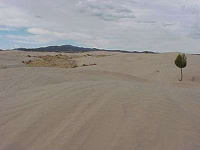 Little Sahara Sand Dunes
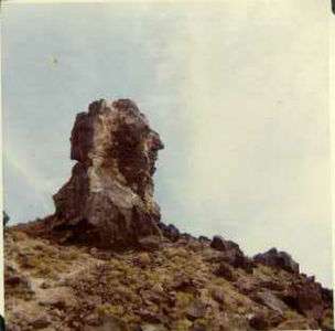 The Great Stone Face
 Notch Peak as seen from the south on the valley floor
 Topaz Internment Camp
See also
- Cove Fort, Utah
- National Register of Historic Places listings in Millard County, Utah
- USS Millard County (LST-987)
- Willden Fort
References
- "State & County QuickFacts". United States Census Bureau. Archived from the original on June 6, 2011. Retrieved December 29, 2013.
- "Find a County". National Association of Counties. Retrieved June 7, 2011.
- Van Atta, Dale (January 22, 1977). "You name it - there's a town for it". The Deseret News. p. 15. Retrieved October 18, 2015.
- "Utah: Individual County Chronologies". Utah Atlas of Historical County Boundaries. Newberry Library. 2008. Retrieved June 26, 2015.
- Jenson, Andrew. Encyclopedic History of the Church of Jesus Christ of Latter-day Saints. (Salt Lake City, Utah: Deseret News Press, 1941) p. 250
- Millard County UT Google Maps (accessed 27 March 2019)
- ""Highest Point in Utah Counties". Peakbagger (accessed 27 March 2019)". Archived from the original on March 27, 2019. Retrieved March 27, 2019.
- "2010 Census Gazetteer Files". US Census Bureau. August 22, 2012. Retrieved June 25, 2015.
- The Great Stone Face, Millard Co, Utah State Historical Society; J. Willard Marriott Library, University of Utah, retrieved September 15, 2014
- "Places to see: Utah Historical Sites", UtahOutdoorActivities.com, Utah Outdoor Activities, retrieved September 15, 2014
- Arave, Lynn (May 9, 2010), "Does the Great Stone Face really resemble the Prophet Joseph?", Deseret News
- Little Sahara Recreation Area.
- "US Decennial Census". US Census Bureau. Retrieved June 25, 2015.
- "Historical Census Browser". University of Virginia Library. Retrieved June 25, 2015.
- Forstall, Richard L., ed. (June 25, 1995). "Population of Counties by Decennial Census: 1900 to 1990". US Census Bureau. Retrieved March 27, 2015.
- "Census 2000 PHC-T-4. Ranking Tables for Counties: 1990 and 2000" (PDF). US Census Bureau. April 2, 2001. Retrieved June 25, 2015.
- "QuickFacts. Utah counties". Retrieved May 17, 2020.
- Millard County QuickFacts from the US Census Bureau Archived June 6, 2011, at the Wayback Machine
- "U.S. Census website". Retrieved February 15, 2017.
- Leip, David. "Atlas of US Presidential Elections". uselectionatlas.org. Retrieved March 31, 2018.
- Jenson, Andrew (2004). Church Chronology. Whitefish MT: Kessinger Publishing. p. 54. ISBN 1-4179-6854-0.
External links
| Wikimedia Commons has media related to Millard County, Utah. |
- Official website
- Fossils In Millard County, Utah Visits to two world famous fossil localities in Millard County—roughly 505 and 475 million years old, respectively.
Places adjacent to Millard County, Utah | |
|---|---|
Municipalities and communities of Millard County, Utah, United States | ||
|---|---|---|
| Cities | Map of Utah highlighting Millard County | |
| Towns | ||
| CDPs | ||
| Unincorporated communities | ||
| Ghost towns | ||
| Indian reservation | ||
| Footnotes | ‡This populated place also has portions in an adjacent county or counties | |
Salt Lake City (capital) | |||||||||||||
| Topics |
|  | |||||||||||
| Society |
| ||||||||||||
| Regions | |||||||||||||
| Largest cities |
| ||||||||||||
| Counties | |||||||||||||
| Attractions |
| ||||||||||||
| Authority control |
|
|---|