Springville, Utah
Springville is a city in Utah County, Utah, United States that is part of the Provo-Orem Metropolitan Statistical Area. The population was 29,466 in 2010, according to the United States Census.[5] Springville is a bedroom community for commuters who work in the Provo-Orem and Salt Lake City metropolitan areas. Other neighboring cities include Spanish Fork and Mapleton. Springville has the nickname of "Art City" or "Hobble Creek".
Springville, Utah | |
|---|---|
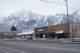 Main Street with the snowy Wasatch Mountains in the background | |
| Nickname(s): Art City | |
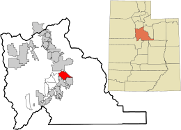 Location in Utah County and the state of Utah | |
| Coordinates: 40°9′46″N 111°36′15″W | |
| Country | United States |
| State | Utah |
| County | Utah |
| Settled | September 18, 1850 |
| Incorporated | April 4, 1853 |
| Named for | a local spring |
| Government | |
| • Mayor | Richard J. Child |
| Area | |
| • Total | 14.39 sq mi (37.28 km2) |
| • Land | 14.34 sq mi (37.15 km2) |
| • Water | 0.05 sq mi (0.13 km2) |
| Elevation | 4,577 ft (1,395 m) |
| Population (2010) | |
| • Total | 29,466 |
| • Estimate (2019)[2] | 33,310 |
| • Density | 2,307.86/sq mi (891.04/km2) |
| Time zone | UTC−7 (Mountain (MST)) |
| • Summer (DST) | UTC−6 (MDT) |
| ZIP code | 84663 |
| Area code(s) | 385, 801 |
| FIPS code | 49-72280[3] |
| GNIS feature ID | 1446057[4] |
| Website | www |
History
Springville was first explored in 1776 by Father Silvestre Vélez de Escalante, a Franciscan padre. What became Springville lay along the wagon route called the Mormon Road that Mormon pioneers and 49ers traveled through southern Utah, northern Arizona, southern Nevada and Southern California. From 1855, each winter trains of freight wagons traveled on this road across the deserts between Los Angeles and Salt Lake City until the late 1860s when the railroad arrived in Utah.[6] Springville was settled in 1850 by eight pioneer families who crossed the plains to Salt Lake Valley from the East and were directed by Brigham Young to settle 50 miles (80 km) further south.
Incorporated in February 1853, the pioneers called the city Hobble Creek because their horses were often hobbled (by loosely tying their front feet together) and left along the stream to graze in the lush grass. If the horses wandered into the creek, the hobbles came off in the water. As the town grew, the name was changed to Springville, after the Fort Springville. Fort Springville was named after the many freshwater springs in the area, particularly near the fort. The original name was not completely lost, however, as the canyon stream (and associated canyons), a local elementary school, and city-owned golf course have retained the name Hobble Creek.[7][8]
Springville is known as "Art City" due to its strong development of the arts. Springville is home to the Springville Museum of Art, Utah's oldest museum for the visual fine arts (circa 1937).[9] The museum, housed in a historic Spanish Colonial Revival-style building, showcases collections of many well-known artists, both local and national, including collections of Utah art, a major Soviet collection, early Americana, and the European Steed collection. Springville is the birthplace of noted sculptor Cyrus Dallin. The main street is dotted with bronze statues, including several from local sculptors Gary Price and Jeff Decker.
Springville is a thriving community which has experienced steady growth over the past ten years. The current population is projected to grow to more than 50,000 over the next ten years, in line with the expected future expansion of its commercial, office, retail, and industrial sectors along the city's I-15 corridor.
Geography
According to the United States Census Bureau, the city has an area of 14.4 square miles (37.4 km2), of which 14.4 square miles (37.2 km2) is land and 0.04 square miles (0.1 km2), or 0.34%, is water.[10] Springville is on the west side of the Wasatch Mountain Range and 3 miles (5 km) east of the average shoreline of Utah Lake and almost entirely east of Interstate 15. All vehicular traffic that transports goods to the north, south, east and west funnels through the interstate hub near Springville's strategically important freeway location. A great potential with its strong connection to the arts, Springville is thriving community that has experienced steady growth over the past ten years. Its current population of 31, 205 continues to increase with 4.6% annual growth.
Demographics
| Historical population | |||
|---|---|---|---|
| Census | Pop. | %± | |
| 1860 | 1,357 | — | |
| 1870 | 1,661 | 22.4% | |
| 1880 | 2,312 | 39.2% | |
| 1890 | 2,849 | 23.2% | |
| 1900 | 4,322 | 51.7% | |
| 1910 | 3,356 | −22.4% | |
| 1920 | 3,010 | −10.3% | |
| 1930 | 3,748 | 24.5% | |
| 1940 | 4,796 | 28.0% | |
| 1950 | 6,475 | 35.0% | |
| 1960 | 7,913 | 22.2% | |
| 1970 | 8,790 | 11.1% | |
| 1980 | 12,101 | 37.7% | |
| 1990 | 13,950 | 15.3% | |
| 2000 | 20,424 | 46.4% | |
| 2010 | 29,466 | 44.3% | |
| Est. 2019 | 33,310 | [2] | 13.0% |
| U.S. Decennial Census[11] | |||
As of the census[3] of 2000, there were 20,424 people, 5,975 households, and 5,024 families residing in the city. The population density was 1,770.5 people per square mile (683.3/km²). There were 6,229 housing units at an average density of 540.0 per square mile (208.4/km²). The city's racial makeup was 94.58% White, 0.11% African American, 0.62% Native American, 0.35% Asian, 0.28% Pacific Islander, 2.23% from other races, and 1.83% from two or more races. Hispanic or Latino of any race were 4.77% of the population.
There were 5,975 households, of which 51.5% had children under the age of 18 living with them, 72.4% were married couples living together, 8.7% had a female householder with no husband present, and 15.9% were non-families. 13.2% of all households were made up of individuals and 5.8% had someone living alone who was 65 years of age or older. The average household size was 3.41 and the average family size was 3.76.
In the city, the population was spread out with 37.4% under the age of 18, 12.7% from 18 to 24, 28.0% from 25 to 44, 14.0% from 45 to 64, and 7.9% who were 65 years of age or older. The median age was 25 years. The heavily weighted 18- to 24-year-old demographic is largely due to the city slowly attracting students and graduates from Brigham Young University, in the adjoining city of Provo, as well as Utah Valley University in the nearby city of Orem. For every 100 females, there are 98.5 males. For every 100 females age 18 and over, there were 94.9 males.
The city's median household income was $46,472, and the median family income was $48,845. Males had a median income of $37,942 versus $26,098 for females. The city's per capita income was $15,634. About 6.6% of families and 8.0% of the population were below the poverty line, including 10.1% of those under age 18 and 4.0% of those age 65 or over.
Business
Major businesses/employers in Springville include the following:
- digEcor, Inc, manufacturer of the digEplayer portable inflight entertainment device, is headquartered in Springville.
- Flowserve, manufacturer of large valves, has a facility in Springville's Industrial Park.
- Modere, which relocated its corporate headquarters to Springville in 2003.
- Stouffer's, a division of Nestle, also has a plant in Springville's Industrial Park
- Wing Enterprises, maker of the Little Giant Ladder Systems is headquartered in Springville.
- W.W. Clyde Company, a heavy construction firm.
- Namify, a company specializing in name tags and other printing services.
- Tatton Baird, Maker of custom hats and accessories.

Local events
Art City Days, held each year in early June, is one of the first city celebrations of the summer season in Utah Valley. Residents join in a variety of activities to celebrate their community, its history, and the warmer weather. Activities include a parade, carnival, hot air balloons, contests, sporting events, and fireworks.[12]
Springville is also home to the Springville World Folkfest, a week-long celebration of folk dance and music held every July at the outdoor amphitheater in the Spring Acres Arts Park. Folk dance groups travel from around the world to participate in this festival. Folkfest performers are housed by host families in the Springville area.
Every May, Springville hosts the annual Indian Festival of Utah also in Spring Acres Arts Park, the state's only cultural event devoted to East Indian, Pakistani, and South Asian communities across the Salt Lake City metropolitan area. Formerly held in nearby Spanish Fork, it represents the small but thriving Indian American and South Asian American communities of northern Utah.
Library
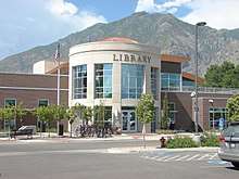
With Springville growing at such a fast rate, the need for a new library soon arose. The old library, the Springville Carnegie Library, could not fit the needs of the rapidly growing city. Construction began on the new library in 2008 and was finished in 2011. Along with having over one million books, movies, and playaways, the new library hosts events, classes, and children's programs. Local youth favorites being coding clubs, teen night, and LEGO clubs.
Education
Springville is served by Nebo School District. Public schools in this district within Springville include Springville High School, Springville Junior High School, Art City Elementary, Brookside Elementary, Cherry Creek Elementary, Sage Creek Elementary, and Westside Elementary. Reagan Academy and Merit Academy, both charter schools, are also in Springville.
Climate
Under the Köppen climate classification, Springville has a humid subtropical climate (Cfa) or a humid continental climate (Dfa) depending on which variant of the system is used.
| Climate data for Springville, Utah | |||||||||||||
|---|---|---|---|---|---|---|---|---|---|---|---|---|---|
| Month | Jan | Feb | Mar | Apr | May | Jun | Jul | Aug | Sep | Oct | Nov | Dec | Year |
| Average high °F (°C) | 40 (4) |
46 (8) |
57 (14) |
65 (18) |
75 (24) |
85 (29) |
94 (34) |
92 (33) |
82 (28) |
67 (19) |
52 (11) |
40 (4) |
66 (19) |
| Average low °F (°C) | 22 (−6) |
26 (−3) |
33 (1) |
39 (4) |
47 (8) |
54 (12) |
61 (16) |
60 (16) |
51 (11) |
40 (4) |
31 (−1) |
24 (−4) |
41 (5) |
| Average precipitation inches (mm) | 1.9 (48) |
1.9 (48) |
1.9 (48) |
2.0 (51) |
2.1 (53) |
1.2 (30) |
0.8 (20) |
1.0 (25) |
1.4 (36) |
2.0 (51) |
1.7 (43) |
1.9 (48) |
19.8 (501) |
| Source: weather.com [13] | |||||||||||||
Photos
 This building functioned as the Springville, Utah public library from 1922 to 1965, when the library was moved to a newer building. A sculpture of Mark Twain reading a book now adorns the lawn.
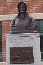
 The Springville, Utah Civic Center building with Dallin Pioneer Mother Memorial. The Dallin sculpture was moved from its nearby park site when the new Civic Center Building was erected.
 This is the Dallin House at 253 S. 300 E. associated with sculptor Cyrus E. Dallin in Springville. Built about 1905, the sculptor apparently lived there at some point in later life.
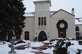 The Art Museum is on 400 South.
 The Central Bank on South Main Street.
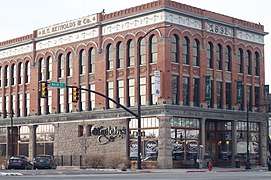 This fine old building is at the corner of 200 South and Main Street.
 Springville, Utah's World Folkfest
Notable residents
- Charity Anderson (b. 2000), dancer
- Jeff Decker (b. 1966), sculptor
See also
- List of cities and towns in Utah
References
- "2018 U.S. Gazetteer Files". United States Census Bureau. Retrieved February 16, 2020.
- "Population and Housing Unit Estimates". Retrieved May 21, 2020.
- "U.S. Census website". United States Census Bureau. Retrieved January 31, 2008.
- "US Board on Geographic Names". United States Geological Survey. October 25, 2007. Retrieved January 31, 2008.
- Bureau, US Census. "Census.gov". census.gov. Retrieved May 12, 2017.
- Randolph Barnes Marcy, The Prairie Traveler: A Hand-book for Overland Expeditions, PUBLISHED BY AUTHORITY OF THE WAR DEPARTMENT, 1859; LIST OF ITINERARIES; ITINERARY VI.--From Great Salt Lake City to Los Angeles and San Francisco, California
- U.S. Geological Survey Geographic Names Information System: Hobble Creek
- About Utah Valley, Utah History, Utah City Histories
- http://www.smofa.org/museum_info/history/index.html
- "Geographic Identifiers: 2010 Demographic Profile Data (G001): Springville city, Utah". United States Census Bureau. Retrieved March 8, 2012.
- "Census of Population and Housing". Census.gov. Retrieved June 4, 2015.
- http://www.springville.org/art-city-days/
- Average Weather for Springville, UT - Temperature and Precipitation. Weather.com. Retrieved on January 28, 2016.
External links
| Wikimedia Commons has media related to Springville, Utah. |
Places adjacent to Springville, Utah | ||||||||||
|---|---|---|---|---|---|---|---|---|---|---|
| ||||||||||
Municipalities and communities of Utah County, Utah, United States | ||
|---|---|---|
| Cities | 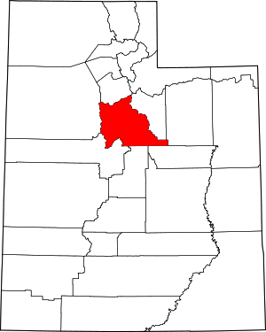 Map of Utah highlighting Utah County | |
| Towns | ||
| CDPs | ||
| Unincorporated communities | ||
| Indian reservation | ||
| Ghost towns | ||
| Footnotes | ‡This populated place also has portions in an adjacent county or counties | |
| Authority control |
|
|---|