Sanpete County, Utah
Sanpete County (/sænˈpiːt/ san-PEET) is a county in the U.S. state of Utah. As of the 2010 United States Census, the population was 27,822.[1] Its county seat is Manti,[2] and its largest city is Ephraim. The county was created in 1850.[3]
Sanpete County | |
|---|---|
 | |
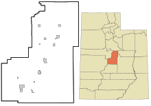
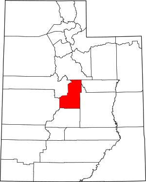 Location within the U.S. state of Utah | |
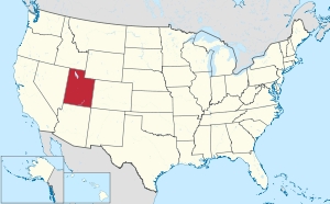 Utah's location within the U.S. | |
| Coordinates: 39°22′N 111°35′W | |
| Country | |
| State | |
| Founded | January 31, 1850 |
| Named for | Chief Sanpitch |
| Seat | Manti |
| Largest city | Ephraim |
| Area | |
| • Total | 1,603 sq mi (4,150 km2) |
| • Land | 1,590 sq mi (4,100 km2) |
| • Water | 12 sq mi (30 km2) 0.8% |
| Population (2010) | |
| • Total | 27,822 |
| • Estimate (2019) | 30,939 |
| • Density | 19.5/sq mi (7.5/km2) |
| Time zone | UTC−7 (Mountain) |
| • Summer (DST) | UTC−6 (MDT) |
| Congressional districts | 2nd, 4th |
| Website | sanpete |
History
The Sanpete Valley may have been traversed or inhabited as long as 32,000 BP, by small bands of hunters. Such lifestyle probably continued for about 20,000 years, at which time the extinction of larger game animals forced a change. About 8,500 years ago, different groups (characterized by use of Atlanta, millstones and textiles) came onto the scene. These also departed the area about 2,500 years ago, for unknown reasons, after which the area was probably unvisited by humans for 1,500 years.
Archeological evidence indicates that the Fremont people appeared next on the stage, the first inhabitants to domesticate crops and to create relatively large communal settlements. In this county the best-known Fremont site to date is "Witch's Knoll" three miles (5 km) SE of Ephraim. Around 1300 AD the evidence of Fremont habitation also ceases. The most recent group of indigenous Americans in the Sanpete region are the Ute, Paiute, Goshute and Shoshoni, all sharing a common language family called Numic.[4]
The largely uninhabited Great Basin was occupied by the Mormon pioneers beginning in summer 1847. The first few years were spent establishing a base in the Great Salt Lake Valley, then groups were sent - usually by directive of the church leaders - to settle the more outlying areas. In 1849 two Ute chiefs traveled to the Salt Lake Valley to request that such settlements be made in the Sanpete Valley. The chiefs, Walkara and Sowiette, asked Mormon leader Brigham Young to settle a group of his people in the valley of Sanpitch,[4] about 125 miles (201 km) to the south. Young sent a party to explore the area in August of that year. It was deemed favorable to settlement, and Brigham Young called Isaac Morley and George Washington Bradley to organize about fifty families to move south and settle "San Pete."[4] The group of 224 arrived on November 19.led by Isaac Morley, Charles Shumway, and Seth Taft and George Washington Bradley. After some debate, the first settlement in the valley was established on the present site of Manti, Utah.[4]
The State of Deseret enacted the county effective January 31, 1850. It was named for the Ute chief Sanpitch, which was changed to Sanpete.[5] According to William Bright, the name comes from the Ute word saimpitsi, meaning "people of the tules".[6]
The county boundaries were adjusted a dozen times during the 19th century. An adjustment in 1913 and a refining of the county boundary definitions in 1919 brought Sanpete County to its present configuration.[3]
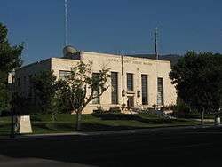
The Sanpete County Courthouse, completed in 1935 by the Works Project Administration, is on the National Register of Historic Places.[7]
Geography
The Sanpete Valley runs from north to south through the center of the county.[8] The county is sloped to the south, with its highest point east of Ephraim, on South Tent Mountain[8] at 11,285' (3440m) ASL.[9] The county has a total area of 1,603 square miles (4,150 km2), of which 1,590 square miles (4,100 km2) is land and 12 square miles (31 km2) (0.8%) is water.[10] The geographical center of Utah is located in Sanpete County, just west of Ephraim.
Sanpete County is bounded along its eastern side by the Wasatch Plateau (sometimes known as the Manti Mountains). The Wasatch Plateau rises to elevations of approximately 11,000 feet (3,300 m). Most of the Wasatch Plateau is encompassed by the Manti Division of the Manti-La Sal National Forest. Runoff from the western slopes of these mountains provides water to the county's cities and agricultural areas. Central Sanpete is dominated by the Sanpete Valley (sometimes known as the Sanpitch Valley), where most of the county's cities are located. The western side of the valley is bounded by the lower and drier San Pitch Mountains, which also form part of the western boundary of the county. The San Pitch River, runs from north to south through Sanpete and empties into the Sevier River in southwestern Sanpete. This portion of the Sevier River Valley is known as Gunnison Valley.
Major Highways
- United States Highway US-89
- Utah State Highway UT-28
- Utah State Highway UT-31
- Utah State Highway UT-116
- Utah State Highway UT-132
- Utah State Highway UT-137
- Utah State Highway UT-264
Adjacent counties
- Utah County - north
- Carbon County - northeast
- Emery County - east
- Sevier County - south
- Millard County - southwest
- Juab County - northwest
Protected areas
- Bald Mountain Wildlife Management Area
- Fishlake National Forest (part)
- Hilltop Wildlife Management Area
- Manti-La Sal National Forest (part)
- Manti Wildlife Management Area
- Mayfield Face Wildlife Management Area
- Palisade State Park
- Spring City Wildlife Management Area
- Uinta-Wasatch-Cache National Forest (part)
- Yuba State Park
Lakes
- Blue Lake
- Duck Fork Reservoir
- Emery Reservoir
- Ferron Reservoir
- Gunnison Reservoir
- Henningson Reservoir
- Huntington Reservoir
- Island Lake
- Julius Flat Reservoir
- Lower Gooseberry Reservoir
- Miller Flat Reservoir (part)
- Rolfson Reservoir
- Spinners Reservoir
- Woods Lake
Demographics
| Historical population | |||
|---|---|---|---|
| Census | Pop. | %± | |
| 1850 | 365 | — | |
| 1860 | 3,815 | 945.2% | |
| 1870 | 6,786 | 77.9% | |
| 1880 | 11,557 | 70.3% | |
| 1890 | 13,146 | 13.7% | |
| 1900 | 16,313 | 24.1% | |
| 1910 | 16,704 | 2.4% | |
| 1920 | 17,505 | 4.8% | |
| 1930 | 16,022 | −8.5% | |
| 1940 | 16,063 | 0.3% | |
| 1950 | 13,891 | −13.5% | |
| 1960 | 11,053 | −20.4% | |
| 1970 | 10,976 | −0.7% | |
| 1980 | 14,620 | 33.2% | |
| 1990 | 16,259 | 11.2% | |
| 2000 | 22,763 | 40.0% | |
| 2010 | 27,822 | 22.2% | |
| Est. 2019 | 30,939 | 11.2% | |
| US Decennial Census[11] 1790–1960[12] 1900–1990[13] 1990–2000[14] 2010–2018[1] 2019[15] | |||
2000 census
As of the 2000 United States Census, there were 22,763 people, 6,547 households, and 5,067 families in the county. The population density was 14.3/sqmi (5.53/km2). There were 7,879 housing units at an average density of 4.96/sqmi (1.91/km2). The racial makeup of the county was 92.43% White, 0.31% Black or African American, 0.87% Native American, 0.48% Asian, 0.36% Pacific Islander, 4.06% from other races, and 1.49% from two or more races. 6.63% of the population were Hispanic or Latino of any race.
In 2005 Sanpete County had a population that was 88.7% non-Hispanic whites. African Americans constituted 0.5% of the population. Native Americans were 1.0% of the population. Asians were 0.8% of the population. Pacific Islanders were growing faster in numbers than Asians and were tied with Asians at 0.8%. 8.1% of the population was now Latino.[16]
There were 6,547 households out of which 43.40% had children under the age of 18 living with them, 67.00% were married couples living together, 7.20% had a female householder with no husband present, and 22.60% were non-families. 17.80% of all households were made up of individuals and 10.10% had someone living alone who was 65 years of age or older. The average household size was 3.27 and the average family size was 3.68.
The county population contained 33.20% under the age of 18, 16.40% from 18 to 24, 21.80% from 25 to 44, 17.80% from 45 to 64, and 10.80% who were 65 years of age or older. The median age was 25 years. For every 100 females there were 102.40 males. For every 100 females age 18 and over, there were 100.90 males.
The median income for a household in the county was $33,042, and the median income for a family was $37,796. Males had a median income of $30,527 versus $19,974 for females. The per capita income for the county was $12,442. About 10.40% of families and 15.90% of the population were below the poverty line, including 13.90% of those under age 18 and 9.60% of those age 65 or over.
Economy
Sanpete County is a largely agricultural region of the state, dotted with rural farming towns. Agriculture, livestock, small businesses, government employment, and Snow College form the economic backbone of the county.
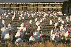
A significant industry in the county is turkey ranching and the Moroni Feed Company, a turkey producing and processing cooperative. Moroni Feed Company is a part owner of the marketing cooperative Norbest . Moroni Feed Company operates several divisions throughout the county, including a turkey processing plant, hatchery, feed mill, propane store, and sales office located in and near the town of Moroni. The company employs over 600 people throughout the state, with the corporate headquarters located near Moroni. Numerous turkey barns and sheds dot the landscape; primarily around Moroni and the other northern Sanpete towns.
Alfalfa fields and other animal feed crops make up the bulk of the agricultural activity and economy of the county.
Communities
Cities
- Centerfield
- Ephraim
- Fairview
- Fountain Green
- Gunnison
- Manti (county seat)
- Moroni
- Mount Pleasant
- Spring City
Unincorporated communities
Ghost towns
- Clarion
- Manasseh
Politics
Sanpete County has traditionally voted Republican. In no national election since 1936 has the county selected the Democratic Party candidate (as of 2016).
| Year | Republican | Democratic | Third parties |
|---|---|---|---|
| 2016 | 65.1% 6,673 | 10.4% 1,061 | 24.5% 2,513 |
| 2012 | 88.1% 8,406 | 10.3% 980 | 1.7% 161 |
| 2008 | 75.1% 6,664 | 18.4% 1,631 | 6.6% 583 |
| 2004 | 82.3% 7,004 | 14.0% 1,189 | 3.7% 314 |
| 2000 | 77.8% 5,781 | 16.3% 1,211 | 5.9% 438 |
| 1996 | 58.8% 3,631 | 25.4% 1,568 | 15.8% 978 |
| 1992 | 44.8% 2,995 | 19.5% 1,302 | 35.7% 2,388 |
| 1988 | 70.3% 4,579 | 28.0% 1,822 | 1.8% 116 |
| 1984 | 81.3% 5,507 | 18.1% 1,227 | 0.6% 43 |
| 1980 | 77.8% 5,143 | 19.1% 1,260 | 3.2% 211 |
| 1976 | 62.1% 3,683 | 32.4% 1,925 | 5.5% 327 |
| 1972 | 70.7% 3,995 | 21.6% 1,220 | 7.7% 437 |
| 1968 | 62.2% 3,304 | 31.9% 1,696 | 5.9% 312 |
| 1964 | 50.7% 2,620 | 49.3% 2,547 | |
| 1960 | 60.4% 3,322 | 39.6% 2,180 | 0.1% 3 |
| 1956 | 68.6% 3,883 | 31.4% 1,778 | |
| 1952 | 65.1% 4,146 | 34.9% 2,221 | |
| 1948 | 52.0% 3,336 | 47.4% 3,041 | 0.6% 36 |
| 1944 | 51.0% 3,196 | 49.0% 3,071 | |
| 1940 | 51.3% 3,722 | 48.6% 3,524 | 0.1% 4 |
| 1936 | 40.6% 2,738 | 58.7% 3,959 | 0.8% 51 |
| 1932 | 46.1% 3,147 | 52.7% 3,600 | 1.3% 86 |
| 1928 | 59.6% 3,694 | 40.1% 2,482 | 0.3% 19 |
| 1924 | 56.4% 3,374 | 37.2% 2,228 | 6.4% 381 |
| 1920 | 60.2% 3,741 | 38.7% 2,406 | 1.2% 72 |
| 1916 | 45.2% 2,918 | 52.3% 3,382 | 2.5% 162 |
| 1912 | 42.0% 2,488 | 33.5% 1,984 | 24.6% 1,455 |
| 1908 | 57.8% 3,334 | 40.0% 2,307 | 2.3% 131 |
| 1904 | 66.7% 3,829 | 30.3% 1,741 | 3.1% 175 |
| 1900 | 59.1% 3,575 | 40.4% 2,441 | 0.5% 31 |
| 1896 | 34.9% 1,813 | 65.1% 3,387 |
References
- "State & County QuickFacts". United States Census Bureau. Archived from the original on February 4, 2016. Retrieved December 29, 2013.
- "Find a County". National Association of Counties. Archived from the original on June 26, 2015. Retrieved June 7, 2011.
- "Utah: Individual County Chronologies". Utah Atlas of Historical County Boundaries. The Newberry Library. 2008. Archived from the original on March 6, 2016. Retrieved June 26, 2015.
- "Albert Antrei & Allen Roberts A History of Sanpete County (1999). pp. 19-25 (accessed 31 March 2019)" (PDF). Archived (PDF) from the original on April 1, 2019. Retrieved April 1, 2019.
- "Where did Sanpete get its Name?". Sanpete.com. Sanpete County UT. Archived from the original on May 23, 2013. Retrieved July 21, 2013.
- Bright, William (2004). Native American Placenames of the United States. University of Oklahoma Press. p. 419. ISBN 978-0-8061-3598-4. Archived from the original on January 11, 2014. Retrieved October 13, 2016.
- John McCormick (1984). "Utah State Historical Society Structure/Site Information: Sanpete County Courthouse". National Park Service. Retrieved August 13, 2019. With accompanying photo from 1984
- "Sanpete County UT Google Maps (accessed 31 March 2019)". Archived from the original on April 1, 2019. Retrieved April 1, 2019.
- "Utah County High Points/Sanpete Co. Peakbagger (accessed 31 March 2019)". Archived from the original on March 27, 2019. Retrieved April 1, 2019.
- "2010 Census Gazetteer Files". US Census Bureau. August 22, 2012. Archived from the original on March 4, 2016. Retrieved June 25, 2015.
- "US Decennial Census". US Census Bureau. Archived from the original on May 12, 2015. Retrieved June 25, 2015.
- "Historical Census Browser". University of Virginia Library. Archived from the original on August 11, 2012. Retrieved June 25, 2015.
- Forstall, Richard L., ed. (June 25, 1995). "Population of Counties by Decennial Census: 1900 to 1990". US Census Bureau. Archived from the original on April 3, 2015. Retrieved March 27, 2015.
- "Census 2000 PHC-T-4. Ranking Tables for Counties: 1990 and 2000" (PDF). US Census Bureau. April 2, 2001. Archived (PDF) from the original on December 18, 2014. Retrieved June 25, 2015.
- "QuickFacts. Utah counties". Archived from the original on January 19, 2020. Retrieved May 17, 2020.
- 2005 Census Reports at www.census.gov
- Leip, David. "Atlas of US Presidential Elections". uselectionatlas.org. Archived from the original on March 23, 2018. Retrieved March 31, 2018.
Places adjacent to Sanpete County, Utah | ||||||||||
|---|---|---|---|---|---|---|---|---|---|---|
| ||||||||||
Municipalities and communities of Sanpete County, Utah, United States | ||
|---|---|---|
| Cities | Map of Utah highlighting Sanpete County | |
| Towns | ||
| Unincorporated communities | ||
| Ghost towns | ||
Salt Lake City (capital) | |||||||||||||
| Topics |
|  | |||||||||||
| Society |
| ||||||||||||
| Regions | |||||||||||||
| Largest cities |
| ||||||||||||
| Counties | |||||||||||||
| Attractions |
| ||||||||||||
| Authority control |
|
|---|