Grand Staircase–Escalante National Monument
The Grand Staircase–Escalante National Monument (GSENM) is a United States national monument originally designated in 1996 as 1,880,461 acres (7,610 km2)[1] of protected land in southern Utah. In 2017, the monument's size was reduced by a succeeding presidential proclamation. The land is among the most remote in the country; it was the last to be mapped in the contiguous United States.[3]
| Grand Staircase–Escalante National Monument | |
|---|---|
IUCN category V (protected landscape/seascape) | |
.jpg) A canyon in Grand Staircase–Escalante National Monument | |
 Location in the United States 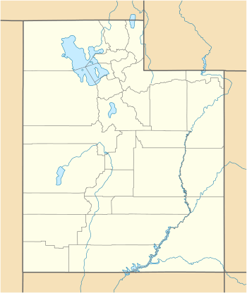 Grand Staircase–Escalante National Monument (Utah) | |
| Location | Kane County and Garfield County, Utah, United States |
| Nearest city | Kanab, Utah |
| Coordinates | 37°24′0″N 111°41′0″W |
| Area | 1,003,863 acres (4,062.49 km2)[1] |
| Established | September 18, 1996 |
| Visitors | 878,000[2] (in 2014) |
| Governing body | Bureau of Land Management |
| Website | Grand Staircase–Escalante National Monument |
There are three main regions: the Grand Staircase, the Kaiparowits Plateau, and the Canyons of the Escalante (Escalante River). All regions are administered by the Bureau of Land Management (BLM) as part of the National Conservation Lands system. President Bill Clinton designated the area as a national monument in 1996 using his authority under the Antiquities Act. Grand Staircase–Escalante is the largest national monument managed by the BLM.
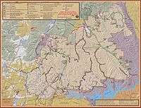
On December 4, 2017, President Donald Trump ordered that the monument's size be reduced by nearly 47% to 1,003,863 acres (4,062 km2),[3] with the remainder divided into three areas, two of which border one another along the Paria River.[4][5] Conservation, angling, hunting, and outdoor recreation groups have filed suit to block any reduction in the national monument, arguing that the president has no legal authority to materially shrink a national monument.[6]
Management
The monument is managed by the Bureau of Land Management (BLM) rather than the National Park Service. This was the first U.S. national monument managed by the BLM. Visitor centers are located in Cannonville, Big Water, Escalante, and Kanab.
Geography
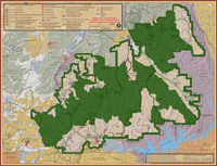
The monument stretches from the towns of Big Water, Glendale, and Kanab, Utah in the southwest, to the towns of Escalante and Boulder in the northeast. Originally encompassing 1,880,461 acres (7,610 km2), the monument was slightly larger in area than the state of Delaware. After a reduction ordered by presidential proclamation in December 2017, the monument now encompasses 1,003,863 acres (4,062 km2).[3]
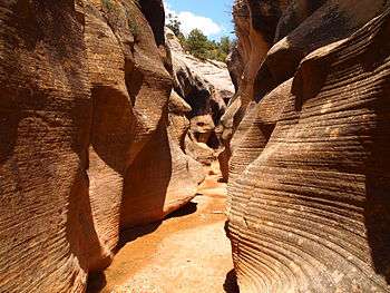
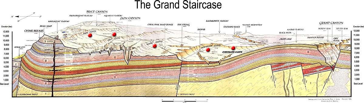
The western part of the monument is dominated by the Paunsaugunt Plateau and the Paria River, and is adjacent to Bryce Canyon National Park. This section shows the geologic progression of the Grand Staircase. Features include the slot canyons of Bull Valley Gorge, Willis Creek, and Lick Wash which are accessed from Skutumpah Road.[7][8]
The center section is dominated by a single long ridge, called the Kaiparowits Plateau from the west, and Fifty-Mile Mountain when viewed from the east. Fifty-Mile Mountain stretches southeast from the town of Escalante to the Colorado River in Glen Canyon. The eastern face of the mountain is a 2,200 ft (670 m) escarpment. The western side (the Kaiparowits Plateau) is a shallow slope descending to the south and west.[7][8]
East of Fifty-Mile Mountain are the Canyons of the Escalante. The monument is bounded by Glen Canyon National Recreation Area on the east and south. The popular hiking, backpacking and canyoneering areas include Calf Creek Falls off Utah Scenic Byway 12, and Zebra Canyon, Harris Wash, and the Devils Garden. The latter areas are accessed via the Hole-in-the-Rock Road which extends southeast from Escalante, near the base of Fifty-Mile Mountain. The Dry Fork Slots of Coyote Gulch and lower Coyote Gulch are also located off the Hole-in-the-Rock Road; however, since December 2017, they are no longer within monument boundaries (see map).[7][8]
Paleontology

Since 2000, numerous dinosaur fossils over 75 million years old have been found at Grand Staircase–Escalante.
In 2002, a volunteer at the monument discovered a 75-million-year-old dinosaur near the Arizona border. On October 3, 2007, the dinosaur's name, Gryposaurus monumentensis (hook-beaked lizard from the monument) was announced in the Zoological Journal of the Linnean Society. G. monumentensis was at least 30 feet (9.1 m) long and 10 feet (3.0 m) tall, and has a powerful jaw with more than 800 teeth.[9][10] Many of the specimens from the Kaiparowits Formation are reposited at the Natural History Museum of Utah in Salt Lake City.
Two ceratopsid (horned) dinosaurs, also discovered at the monument, were introduced by the Utah Geological Survey in 2007. They were uncovered in the Wahweap formation, which is just below the Kaiparowits formation where the duckbill was extracted. They lived about 80 million or 81 million years ago. The two fossils are called the Last Chance skull and the Nipple Butte skull. They were found in 2002 and 2001, respectively.[11] Both were later identified as belonging to Diabloceratops.[12]
In 2013 the discovery of a new species, Lythronax argestes, was announced. It is a tyrannosaur that is approximately 13 million years older than Tyrannosaurus, named for its great resemblance to its descendant. The specimen can be seen at the Natural History Museum of Utah.
Human history

Humans did not settle permanently in the area until the Basketmaker III Era, somewhere around AD 500.[13] Both the Fremont and ancestral Puebloan people lived here; the Fremont hunting and gathering below the plateau and near the Escalante Valley, and the ancestral Puebloans farming in the canyons. Both groups grew corn, beans, and squash, and built brush-roofed pithouses and took advantage of natural rock shelters. Ruins and rock art can be found throughout the monument.
The first record of white settlers in the region dates from 1866, when Captain James Andrus led a group of cavalry to the headwaters of the Escalante River. In 1871 Jacob Hamblin of Kanab, on his way to resupply the second John Wesley Powell expedition, mistook the Escalante River for the Dirty Devil River and became the first Anglo to travel the length of the canyon.
In 1879 the San Juan Expedition crossed through the monument on their way to a proposed Mormon colony in the far southeastern corner of Utah. Traveling on a largely unexplored route, the group eventually arrived at the 1200-foot (400 m) sandstone cliffs that surrounded Glen Canyon. They found the only breach for many miles in the otherwise vertical cliffs, which they named Hole-in-the-Rock. The narrow, steep, and rocky crevice eventually led to a steep sandy slope in the lower section and eventually down to the Colorado River. With winter settling in, the company decided to go down the crevice, rather than retreat. After six weeks of labor, including excavation and the use of explosives to shift rock, they rigged a pulley system to lower their wagons and animals down the resulting road and off the cliff. There they built a ferry, crossed the river and climbed back out through Cottonwood Canyon on the other side.
Controversy

The national monument was declared on September 18, 1996 at the height of the 1996 presidential election campaign by President Bill Clinton, and was controversial from the moment of creation. The declaration ceremony was held at Grand Canyon National Park in Arizona, rather than in Utah.[14]
Local officials such as Democratic U.S. Representative Bill Orton from Utah objected to the designation of the national monument, questioning whether the Antiquities Act allowed such vast amounts of land to be designated.[15][16] However, United States Supreme Court decisions have long established the president's discretion to protect land under the Antiquities Act, and several lawsuits filed in an effort to overturn the designation were dismissed by federal courts.[17][18] Monument designation also nixed the Andalex Coal Mine that was proposed for a remote location on the Kaiparowits Plateau.[19] Wilderness designation for the lands in the monument had long been sought by environmental groups; however, designation of the monument is not the same as wilderness designation, as activities such as motorized vehicle and mountain bike use are allowed.
There are contentious issues peculiar to the state of Utah. Certain plots of land were assigned when Utah became a state (in 1896) as School and Institutional Trust Lands (SITLa, a Utah state agency), to be managed to produce funds for the state school system. These lands included scattered plots in the monument that could no longer be developed. The SITLa plots within the monument were exchanged for federal lands elsewhere in Utah, plus equivalent mineral rights and $50 million cash by an act of Congress, the Utah Schools and Lands Exchange Act of 1998, supported by Democrats and Republicans, and signed into law as Public Law 105-335 on October 31, 1998.[20]
A more difficult problem is the resolution of United States Revised statute 2477 (R.S. 2477) road claims. R.S. 2477 (Section 8 of the 1866 Mining Act) states: "The right-of-way for the construction of highways over public lands, not reserved for public uses, is hereby granted." The statute was repealed by the Federal Land Policy and Management Act (FLPMA) of 1976, but the repeal was subject to valid existing rights.
A process for resolving disputed claims has not been established, and in 1996, the 104th United States Congress passed a law which prohibited the R.S. 2477 (proposed resolution regulations) written by the Clinton Administration from taking effect without congressional approval.[21]
The right to maintain and improve the many unpaved roads in the national monument is disputed, with county officials placing county road signs on the roads they claim and occasionally applying bulldozers to grade claimed roads, while the BLM tries to exert control over the same roads. Litigation between the state and federal government over R.S. 2477 and road maintenance in the national monument is an ongoing issue.[22]
See also
Footnotes
- "National Landscape Conservation System National Monuments" (archive). blm.gov. Bureau of Land Management. April 2012. Retrieved December 10, 2017.
- "FY 2014 GSENM Manager's Report (PDF file link on park's home page)" (PDF). BLM. 2015-01-25. p. 15. Archived from the original (PDF) on 2016-03-12. Retrieved 2016-02-08.
- "Grand Staircase–Escalante National Monument". blm.gov. Bureau of Land Management. 2017. Retrieved December 10, 2017.
- "Presidential Proclamation Modifying the Grand Staircase–Escalante National Monument". Whitehouse.gov. 4 December 2017. Retrieved 4 December 2017.
- Siegel, Josh (4 December 2017). "Trump announces he will shrink Bears Ears, Grand Staircase monuments in Utah". Washingtonexaminer.com. Retrieved 4 December 2017.
- Environmental, conservation groups sue Trump over monument changes. CNN, 4 December 2017
- "Map of Modified Boundaries – Utah GSENM New 2018 Map" (PDF). blm.gov. Bureau of Land Management. 2018. Retrieved December 16, 2019.
- "ArcGIS Dynamic Map of GSENM". blm-egis.maps.arcgis.com. Bureau of Land Management. n.d. Retrieved December 16, 2019.
- "Duck-billed dinosaur amazes scientists". www.usatoday.com. Retrieved 4 December 2017.
- "S. Utah dinosaur had a duck-billed snout – and 800 teeth". Sltrib.com. Archived from the original on 4 June 2011. Retrieved 4 December 2017.
- Bauman, Joe; Boren, Ray (October 4, 2007). "Utah's new dino-stars: Discoveries give clues to distant past". Deseret Morning News.
- Kirkland, J. I.; DeBlieux, D. D. (2007). "New horned dinosaurs from the Wahweap Formation, Grand Staircase–Escalante National Monument, southern Utah" (PDF). Utah Geological Survey Notes. 39 (3): 4–5.
- Grand Staircase Escalante National Monument. Kane County Utah Office of Tourism and Film Commission. Retrieved 2011-10-14.
- Paul Larmer (1996-09-30). "1996: Clinton takes a 1.7 million-acre stand in Utah". High Country News. Retrieved 2016-01-10.
- Mathew Barrett Gross (2002-02-13). "San Rafael Swell monument proposal could prove that Bush realizes the importance of a fair and public process". Headwaters News, University of Montana. Archived from the original on 2007-11-26. Retrieved 2008-01-16.
- Davidson, Lee (Sep 27, 1996). "Orton's bill would erase power to declare permanent monument". Deseret News.
- Utah Ass'n of Counties v. George W. Bush, District Court, D. Utah, 2004.
- The Monumental Legacy of the Antiquites Act of 1906, Mark Squillace, Georgia Law Review, 2003.
- Grahame, John D.; Thomas D. Sisk (2002). "Grand Staircase–Escalante National Monument, Utah (page 3 of 4) Coal Mining vs. Wilderness on the Kaiparowits Plateau". Land Use History of the Colorado Plateau. Northern Arizona University. Archived from the original on 2007-02-03. Retrieved 2007-03-05.
- "Public Law 105-335". US Government Printing Office. 1998. Retrieved 2007-03-04.
- Gamboa, Anthony (February 6, 2004). "Recognition of R.S. 2477 Rights-of-Way under the Department of the Interior's FLPMA Disclaimer Rules and Its Memorandum of Understanding with the State of Utah, B-300912". US Government Accountability Office. Retrieved 2007-03-04.
- "FY 2014 GSENM Manager's Report (PDF file link on park's home page)" (PDF). BLM. 2015-01-25. pp. 6, 14, 15, 55. Archived from the original (PDF) on 2016-03-12. Retrieved 2016-02-08.
References
- Paul Larmer (editor), Give and Take: How the Clinton Administration's Public Lands Offensive Transformed the American West (High Country News Books, 2004) ISBN 0-9744485-0-8
- Bureau of Land Management, Grand Staircase–Escalante NM, Grand Staircase–Escalante National Monument Management Plan (U.S. Dept. of the Interior Bureau of Land Management, 1999)
- David Urmann, Trail Guide to Grand Staircase–Escalante (Gibbs Smith, 1999) ISBN 0-87905-885-4
- Robert B. Keiter, Sarah B. George and Joro Walker (editors), Visions of the Grand Staircase–Escalante: Examining Utah's Newest National Monument (Utah Museum of Natural History and Wallace Stegner Center, 1998) ISBN 0-940378-12-4
- Julian Smith, "Moon Handbooks Four Corners" (Avalon Travel Publishing, 2003) ISBN 1-56691-581-3
- Fleischner, Thomas Lowe, Singing Stone: A Natural History of the Escalante Canyons (University of Utah Press, 1999) ISBN 978-0-87480-619-9
External links
| Wikimedia Commons has media related to: |
| Wikivoyage has a travel guide for Grand Staircase–Escalante National Monument. |
- Bureau of Land Management: official Grand Staircase–Escalante National Monument website
- Grand Staircase Escalante Partners support for public awareness, interpretive, educational, scientific, scenic, historical, and cultural activities.
- Bashkin, Michael; Stohlgren, Thomas J; Otsuki, Yuka; Lee, Michelle; Evangelista, Paul; Belnap, Jayne (2003). "Soil characteristics and plant exotic species invasions in the Grand Staircase–Escalante National Monument, Utah, USA". Applied Soil Ecology. 22: 67–77. CiteSeerX 10.1.1.568.38. doi:10.1016/S0929-1393(02)00108-7.
- Doelling, Hellmut H.; Blackett, Robert E.; Hamblin, Alden H.; Powell, J. Douglas; Pollock, Gayle L. (2000). "Geology of Grand Staircase–Escalante National Monument, Utah" (PDF). In Sprinkel, Douglas A.; Chidsey, Thomas C.; Anderson, Paul B. (eds.). Geology of Utah's Parks and Monuments. Utah Geological Association. ISBN 978-0-9702571-0-9.
- Quigley, Justin James (1999). "Grand Staircase–Escalante National Monument: Preservation or Politics?". Journal of Land, Resources, & Environmental Law. 19: 55.
- United States. Congress. House. (1997). Establishing the Grand Staircase–Escalante National Monument: Oversight Hearing before the Subcommittee on National Parks and Public Lands of the Committee on Resources, House of Representatives, One Hundred Fifth Congress, First Session, On Establishment ... by President Clinton on September 18, 1996: April 29, 1997 Washington. D.C: G.P.O.
| Topics | |
|---|---|
| Lists by state |
|
| Lists by insular areas | |
| Lists by associated state | |
| Other areas | |
| Related | |
| |
| Authority control |
|
|---|