Cache County, Utah
Cache County (/kæʃ/ KASH) is a county on the northern edge of Utah, United States. As of the 2010 United States Census the population was 112,656.[1] Its county seat and largest city is Logan.[2]
Cache County | |
|---|---|
 Cache County Courthouse, July 2009 | |
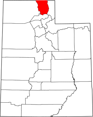 Location within the U.S. state of Utah | |
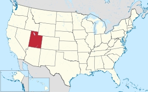 Utah's location within the U.S. | |
| Coordinates: 41.69°N 111.75°W | |
| Country | |
| State | |
| Founded | January 5, 1856 (created) April 4, 1857 (organized) |
| Named for | Fur trade |
| Seat | Logan |
| Largest city | Logan |
| Area | |
| • Total | 1,173 sq mi (3,040 km2) |
| • Land | 1,165 sq mi (3,020 km2) |
| • Water | 8.2 sq mi (21 km2) 0.7% |
| Population (2010) | |
| • Total | 112,656 |
| • Estimate (2019) | 128,289 |
| • Density | 110/sq mi (40/km2) |
| Time zone | UTC−7 (Mountain) |
| • Summer (DST) | UTC−6 (MDT) |
| Congressional district | 1st |
| Website | www |
Cache County is included in the Logan, UT-ID Metropolitan Statistical Area.
History
Indigenous peoples occupied the valleys of present Cache County as much as 10,000 BCE. Near the present epoch, the valley served the Plains Indians and the Shoshone. Trappers and explorers visited the area in the late 18th and early 19th centuries. John Henry Weber and Jim Bridger came through in 1824; Peter Skene Ogden and James Beckwourth passed through in 1825. In July 1855 a group of Mormon settlers drove a herd of cattle into the valley and camped at Haw Bush Spring (present Elkhorn Ranch). However, the extremely cold winter conditions drove the settlers back to the Salt Lake Valley. That summer (1856) local leaders of the LDS Church sent Peter Maughan to establish a permanent settlement in the Cache Valley. His settlement, Maughan's Fort, grew into the present Wellsville.
More settlers arrived in the valley, and by 1859 the settlements of Providence, Mendon, Logan, Richmond, and Smithfield had been established.
In preparation for this influx, the Utah Territory legislature created a county, effective January 5, 1856, with seat and government incomplete. By April 4, 1857 the organization was completed, and Logan became the seat.[3] It was named for the fur stashes, known in French as Caches, made by many of the Rocky Mountain Fur Company trappers. The county gained area in 1862 when its boundary lines with adjacent counties were adjusted. In 1863, the federal government enacted the Idaho Territory, which administratively removed the described portions of Cache County that lay north of the territorial border. Then in 1864, the east part of the county was partitioned to become Rich County. The borders of Cache County have remained in their present state since 1864.
A rail line between Brigham City and Logan was completed in 1873 (Utah and Northern Railway). The line was extended into Idaho, and a connection was made to the transcontinental railroad, which opened the world to Cache County; their crops (especially grain and dairy) began moving to broader markets. The county's sheep population also burgeoned; from 10,000 in 1880 to 300,000 by 1900. By 1900 the Forest Service began regulating grazing practices, which brought the sheep population under control.
There were 16,000 dairy cows in Cache County in 1910. Commercial creameries, flour mills, woolen mills, and knitting factories developed around the farm-based economy. Cache presently continues as the state's leader in dairy products and as a major producer of hay, alfalfa, and grain.[4]
Geography
Cache County lies on the north edge of Utah. Its north border abuts the south border of the state of Idaho. On the western edge of the county are the Wellsville Mountains and on the eastern edge are the Bear River Mountains, both northern branches of the Wasatch Range. The Cache Valley reaches north to the state border. The Bear River Mountains, the northernmost extension of the Wasatch Range, cover the eastern half of the county.[5] The county's highest elevation is Naomi Peak in the NE part of the county, at 9,979' (3042m) ASL.[6] The Bear River flows through Cache Valley. The county has a total area of 1,173 square miles (3,040 km2), of which 1,165 square miles (3,020 km2) is land and 8.2 square miles (21 km2) (0.7%) is water.[7]
Major highways
Adjacent counties
- Oneida County, Idaho - northwest
- Franklin County, Idaho - north
- Bear Lake County, Idaho - northeast
- Rich County - east
- Weber County - south
- Box Elder County - west
Protected areas
- Cache National Forest (part)
- Caribou National Forest (part)
- Hardware Ranch Wildlife Management Area (state park)
- Tony Grove Lake Campground (US Forest Service)
- Millville Face Wildlife Management Area[5]
Lakes
- Crescent Lake
- Cutler Reservoir
- Hyrum Reservoir
- Newton Reservoir
- Porcupine Reservoir
- Tony Grove Lake[5]
Government and politics
Cache County is governed by a seven-member county council and also elects eight officials at large. As of 2019, all county elected officials were members of the Republican Party.[8][9]
Cache County has also trended strongly Republican in national voting. In no national election since 1944 has the county selected the Democratic Party candidate (as of 2016).
| Year | Republican | Democratic | Third parties |
|---|---|---|---|
| 2016 | 45.3% 21,139 | 18.3% 8,563 | 36.4% 17,016 |
| 2012 | 82.9% 35,039 | 14.8% 6,244 | 2.4% 1,010 |
| 2008 | 69.5% 29,127 | 24.6% 10,294 | 6.0% 2,501 |
| 2004 | 81.8% 32,486 | 16.1% 6,375 | 2.2% 870 |
| 2000 | 78.2% 25,920 | 15.6% 5,170 | 6.2% 2,052 |
| 1996 | 63.8% 16,832 | 25.0% 6,595 | 11.2% 2,967 |
| 1992 | 52.0% 15,971 | 16.2% 4,973 | 31.8% 9,781 |
| 1988 | 77.8% 21,766 | 21.0% 5,871 | 1.2% 326 |
| 1984 | 83.7% 22,127 | 15.6% 4,123 | 0.7% 192 |
| 1980 | 78.7% 20,251 | 14.1% 3,639 | 7.2% 1,845 |
| 1976 | 71.7% 16,636 | 23.4% 5,430 | 4.9% 1,128 |
| 1972 | 76.8% 16,538 | 18.7% 4,018 | 4.5% 969 |
| 1968 | 68.8% 11,906 | 25.0% 4,327 | 6.2% 1,070 |
| 1964 | 58.5% 9,326 | 41.5% 6,627 | |
| 1960 | 67.7% 10,281 | 32.4% 4,917 | |
| 1956 | 73.8% 10,349 | 26.2% 3,671 | |
| 1952 | 70.6% 10,167 | 29.4% 4,242 | |
| 1948 | 50.3% 6,514 | 49.3% 6,383 | 0.4% 49 |
| 1944 | 41.3% 4,938 | 58.6% 6,998 | 0.1% 12 |
| 1940 | 39.7% 5,184 | 60.3% 7,867 | 0.1% 7 |
| 1936 | 27.3% 3,258 | 72.0% 8,606 | 0.8% 93 |
| 1932 | 42.2% 4,829 | 57.0% 6,522 | 0.8% 93 |
| 1928 | 52.6% 5,297 | 47.2% 4,748 | 0.3% 26 |
| 1924 | 52.0% 4,973 | 40.9% 3,915 | 7.1% 674 |
| 1920 | 53.9% 5,063 | 45.1% 4,239 | 1.0% 95 |
| 1916 | 41.1% 3,756 | 58.0% 5,305 | 0.9% 81 |
| 1912 | 37.9% 2,825 | 44.3% 3,296 | 17.8% 1,328 |
| 1908 | 52.8% 3,787 | 46.3% 3,317 | 0.9% 67 |
| 1904 | 56.9% 4,008 | 41.9% 2,948 | 1.3% 89 |
| 1900 | 47.6% 2,820 | 52.0% 3,082 | 0.4% 23 |
| 1896 | 16.0% 839 | 84.0% 4,395 |
Demographics
| Historical population | |||
|---|---|---|---|
| Census | Pop. | %± | |
| 1890 | 15,509 | — | |
| 1900 | 18,139 | 17.0% | |
| 1910 | 23,062 | 27.1% | |
| 1920 | 26,992 | 17.0% | |
| 1930 | 27,424 | 1.6% | |
| 1940 | 29,797 | 8.7% | |
| 1950 | 33,536 | 12.5% | |
| 1960 | 35,788 | 6.7% | |
| 1970 | 42,331 | 18.3% | |
| 1980 | 57,176 | 35.1% | |
| 1990 | 70,183 | 22.7% | |
| 2000 | 91,391 | 30.2% | |
| 2010 | 112,656 | 23.3% | |
| Est. 2019 | 128,289 | 13.9% | |
| US Decennial Census[11] 1790–1960[12] 1900–1990[13] 1990–2000[14] 2010–2018[1] 2019[15] | |||
2010 census
As of the 2010 United States Census, there were 112,655 people, 34,722 households, and 26,464 families in the county. The population density was 96.7/sqmi (37.35/km²). There were 37,024 housing units at an average density of 31.78/sqmi (12.28/km²). The racial makeup of the county was 89.12% White, 0.62% Black or African American, 0.61% Native American, 1.88% Asian, 0.39% Pacific Islander, 5.48% from other races, and 1.90% from two or more races. 9.96% of the population was Hispanic or Latino of any race.
There were 34,722 households out of which 41.34% had children under the age of 18 living with them, 76.22% were married couples living together, 7.73% had a female householder with no husband present, and 23.78% were non-families. 16.30% of all households were made up of individuals and 5.54% had someone living alone who was 65 years of age or older. The average household size was 3.14 and the average family size was 3.55.
The county population contained 36.3% under the age of 20, 12.59% from 20 to 24, 26.97% from 25 to 44, 16.41% from 45 to 64, and 7.72% who were 65 years of age or older. The median age was 25.5 years. For every 100 females there were 98.84 males. For every 100 females age 18 and over, there were 99.53 males.
2015
As of 2015, the largest self reported ancestry groups in Cache County were:
- 27.9% were of English ancestry
- 12.1% were of German ancestry
- 7.3% were of Danish ancestry.
- 6.1% were of American ancestry
- 5.2% were of Swedish ancestry
- 5.0% were of Scottish ancestry
- 4.5% were of Irish ancestry
- 3.0% were of Norwegian ancestry
- 2.6% were of Welsh ancestry
- 2.1% were of Italian ancestry
- 2.0% were of Swiss ancestry
- 2.0% were of Dutch ancestry
- 1.5% were of French ancestry
- 0.7% were of Polish ancestry[16]
2016
As of 2016, the largest self reported ancestry groups in Cache County were:
- 28.3% were of English ancestry
- 11.6% were of German ancestry
- 7.4% were of Danish ancestry.
- 5.9% were of American ancestry
- 5.3% were of Swedish ancestry
- 5.1% were of Scottish ancestry
- 4.6% were of Irish ancestry
- 2.9% were of Norwegian ancestry
- 2.7% were of Welsh ancestry
- 2.2% were of Italian ancestry
- 2.2% were of Swiss ancestry
- 1.8% were of French ancestry
- 1.7% were of Dutch ancestry
- 0.8% were of Polish ancestry[17]
Communities

Cities
Townships
- College-Young (merger of the unincorporated communities of College Ward and Young Ward)
Unincorporated communities[5]
- White Horse Village
Former communities
Gallery
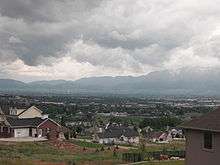 Cache Valley looking south (from North Logan)
.jpg) Logan Tabernacle in Logan
Logan Tabernacle in Logan
References
- "State & County QuickFacts". United States Census Bureau. Retrieved December 29, 2013.
- "Find a County". National Association of Counties. Archived from the original on May 31, 2011. Retrieved June 7, 2011.
- "Utah: Individual County Chronologies". Utah Atlas of Historical County Boundaries. Newberry Library. 2008. Retrieved June 26, 2015.
- Cache County. Utah Division of State History (accessed 30 March 2019)
- Cache County UT Google Maps (accessed 30 March 2019)
- "Utah County High Points/Cache County. Peakbaggers (accessed 30 March 2019)". Archived from the original on March 27, 2019. Retrieved March 31, 2019.
- "2010 Census Gazetteer Files". US Census Bureau. August 22, 2012. Retrieved March 27, 2015.
- Elected Officials - Cache County (accessed 30 March 2019)
- County Council - Cache County (accessed 30 March 2019)
- Leip, David. "Atlas of US Presidential Elections". uselectionatlas.org. Retrieved March 30, 2018.
- "US Decennial Census". US Census Bureau. Archived from the original on April 26, 2015. Retrieved March 27, 2015.
- "Historical Census Browser". University of Virginia Library. Retrieved March 27, 2015.
- Forstall, Richard L., ed. (March 27, 1995). "Population of Counties by Decennial Census: 1900 to 1990". US Census Bureau. Retrieved March 27, 2015.
- "Census 2000 PHC-T-4. Ranking Tables for Counties: 1990 and 2000" (PDF). US Census Bureau. April 2, 2001. Retrieved March 27, 2015.
- https://www.census.gov/quickfacts/fact/table/cachecountyutah/PST045218
- Bureau, US Census. "American FactFinder - Results". factfinder.census.gov. Archived from the original on February 13, 2020. Retrieved March 30, 2018.
- Bureau, US Census. "American FactFinder - Results". factfinder.census.gov. Archived from the original on February 13, 2020. Retrieved March 30, 2018.
External links
| Wikimedia Commons has media related to Cache County, Utah. |
Places adjacent to Cache County, Utah | |
|---|---|
Municipalities and communities of Cache County, Utah, United States | ||
|---|---|---|
| Cities | Map of Utah highlighting Cache County | |
| Towns | ||
| CDPs | ||
| Unincorporated community | ||
| Ghost town | ||
Salt Lake City (capital) | |||||||||||||
| Topics |
|  | |||||||||||
| Society |
| ||||||||||||
| Regions | |||||||||||||
| Largest cities |
| ||||||||||||
| Counties | |||||||||||||
| Attractions |
| ||||||||||||
| Authority control |
|
|---|