Pratas Islands
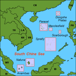
The Pratas Islands (simplified Chinese: 东沙群岛; traditional Chinese: 東沙群島; pinyin: Dōngshā Qúndǎo), also known as the Dongsha Islands or the Tungsha Islands, are three atolls (Pratas Atoll, North Vereker Atoll and South Vereker Atoll) in the north of the South China Sea. They consist of one island, two coral reefs and two banks, and are located about 170 nautical miles (310 km; 200 mi) southeast of Hong Kong.[1][3] The Republic of China (Taiwan) controls them and has declared part of them the Dongsha Atoll National Park. The People's Republic of China claims them as part of Guangdong Province.
| Disputed islands Other names: Dongsha Islands Tungsha Islands | |
|---|---|
 Pratas atoll from space, January 1986. | |
| Geography | |
| Location | South China Sea |
| Coordinates | 20°42′08″N 116°43′39″E |
| Total islands | 1 |
| Major islands | Pratas Island |
| Area | 174 ha (429.96 acres) (land), 64 ha (158.15 acres) (lagoon)[1] |
| Length | 2.8 kilometres (1.7 mi) |
| Width | 0.865 kilometres (0.537 mi) |
| Administered by | |
| Republic of China (Taiwan) | |
| Municipality District | Kaohsiung Cijin |
| Claimed by | |
| People's Republic of China | |
| Province Prefecture-level city District | Guangdong Shanwei Chengqu[2] |
| Demographics | |
| Population | 0 |

Pratas Island is the only area above sea level. It has an area of about 240 hectares (590 acres), including 64 hectares (160 acres) of lagoon, and is the largest of the South China Sea Islands.[4] It is the location of the Dongsha Airport.
The Pratas atoll is circular, with Pratas Island at the west of the atoll, and two large submerged coral reefs around the edge of most of the rest of the atoll.
The North Vereker Bank and South Vereker Bank are adjacent to each other about 40 nautical miles (74 km; 46 mi) to the northwest of the Pratas atoll at 21°N 116°E. North Vereker Bank rises to 11 metres (36 ft) below sea level, and South Vereker Bank to 57 metres (187 ft) below sea level. There are numerous oil wells to the west of the banks.[5]
Name
The English name of the islands derives from the Portuguese Ilhas das Pratas ("Silver Plate Islands"), which was given to the atoll in the 16th century owing to its round shape.
Dongsha is the pinyin romanization of the Mandarin Chinese name Dōngshā Qúndǎo (t 東沙群島, s 东沙群岛), meaning "Eastern Sandy Archipelago". The name distinguishes it from Xisha, the western archipelago, better known as the Paracel Islands.
History
The East Indiaman Earl Talbot was wrecked on the Pratas Islands on or about 22 October 1800 with the loss of all aboard. At the time the islands were known to British sailors as the "Perates". Then the British screw sloop HMS Reynard wrecked in 1851 while going to the aid of another wrecked vessel; the crew were all saved.[6]
In 1859-1861 there was a correspondence between the British Colonial Office and the Hong Kong colonial authorities about building a lighthouse on the main island on the atoll. Despite an offer by a British businessman in Xiamen to build it, it was decided that the cost was too great and the matter lapsed. It is clear from the correspondence that no one supposed the atoll to be a part of any known jurisdiction, which might have required negotiations to be conducted to ensure that construction would be legal.[7]
One consequence of this initiative was that in 1858 the Royal Navy survey ship HMS Saracen completed the first detailed survey of the atoll, resulting in the Plan of the Pratas Reef and Island, J. Richards and others, April 1858 being published by the British Admiralty.[8] On the resulting chart three positions are proposed for a lighthouse, on Pratas Island, on the north-east corner and on the southern edge near where HMS Reynard had stranded. In the north-east corner of the lagoon the chart notes "Anchorage for junks" indicating regular use by fishing and other small vessels taking shelter. The chart's rubric noted that the available safe draft for vessels entering was only 15 feet (4.6m), so restricted to only relatively small vessels.
In 1908-1909 a Japanese businessman named Nishizawa Yoshizi (西澤吉次) established a guano collecting station, destroyed the Dawang Joss House (大王庙), and dug up graves and poured the bone ashes of Chinese fishermen into the sea there, and renamed the atoll "Nishizawa Island",[9][10] but after a diplomatic confrontation, Chinese sovereignty was re-established, and Nishizawa withdrew, after being compensated by the Guangdong provincial government, and after paying compensation for the destruction of a Chinese fishermen's shrine.[11]
Japanese naval personnel occupied Pratas Island during World War II. The Japanese Navy used the island as a weather station and listening outpost until 29 May 1945 when a landing party consisting of Australian commandos and US naval personnel from the submarine USS Bluegill raised the US flag, declared the island a United States territory, and named it Bluegill Island. The landing party destroyed a radio tower, weather station, fuel and ammunition dumps, and several buildings. No lives were lost during this raid as all of the island's occupants fled just days prior to Bluegill's raid.[12][13] The islands were later restored to the Republic of China's Guangdong Province.[14]
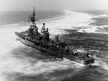
While underway in the South China Sea on 18 July 1965, the USS Frank Knox ran aground on Pratas Reef, and was only freed on 24 August after a very difficult salvage effort.[15]
The islands have been uninhabited, yet nations (including China and Japan) have claimed them to be their overseas territory. After World War II, the islands and the sea around them were mandated by United Nations.
In the Journal of Science (April 1867) there is a nine-page article entitled "The Natural History of Pratas Island in the China Sea" by Dr. Cuthbert Collingwood, the naturalist on board HMS Serpent. It describes what was observed, especially bird life, during a visit of two days while the survey ship lay at anchor. Collingwood explored the island on 30 April 1866.[16]
The islands are part of the Republic of China (Taiwan) with the postal code 817. In 2007, the Taiwanese government designated the Pratas atoll as the Dongsha Atoll National Park, the first marine national park in Taiwan.[17]
Geography

The Pratas Islands are located 850 kilometres (530 miles) southwest of Taipei and 340 kilometres (210 miles) southeast of Hong Kong in the northern part of the South China Sea called the Pratas Terrace (20°43′N 116°42′E).
Pratas Island is 2.8 km (1.7 mi) long and 0.865 km (0.537 mi) wide; it is the only feature of the group above sea level. The island is made up of coral atolls and reef flats. Brush, vines and bushes cover some of the island - the rest is white sand. Flora and fauna on and around Pratas Island include:
- Silver silk tree
- Strawberry tung tree
- Coconut tree
- Little terns
- Turnstones
- Gull-billed terns
- Parrotfish
- Starfish
- Rock lobsters
North and South Vereker Banks are under water.
There are also some seamount formations nearby which are not part of the three atolls:
- Jianfeng Seamount (尖峰海山)
- Maojia Seamount (芼架海山)
- Beipo Seamount (北波海山)
Pratas Island settlement
As a disputed island with no permanent inhabitants, it is visited largely by fishermen, military personnel and researchers. Amateur radio operators participating in the DXCC and Islands on the air awards programs also visit occasionally.[18]
Landmarks
An obelisk was erected after 1946.
In 1954 the ROC Government personnel stationed on Pratas erected a stone tablet on the southern side of the island, facing the ocean.[19]
The Da Wang temple is dedicated to 'Kuang Kang' and 'The South China Sea Goddess' - Mazu. It is said that the statue of Guan Gong came to Pratas Island on a canoe in 1948. The soldiers on Pratas Island built a temple to worship her in 1975. Today, the canoe is still kept in the temple. The joss sticks and candles are donated by soldiers, as was the golden sign hung in front of the statue. There is an 'Ever Green' pavilion in front of the temple which was also built by the soldiers. It is the most verdant place on the island.[19]
The Minister for Internal Affairs of the ROC erected the South China Sea Defense stone tablet to declare Republic of China sovereignty in 1989.[19]
In July 1991 the Kaohsiung City Government erected the Pratas Island measuring memorial stone tablet as a symbol that Pratas Island falls within the jurisdiction of Kaohsiung City.[19] Within Kaohsiung, the islands belong to Cijin District.
The ROC Government established the Triangulation Benchmark as the triangulation point for Pratas Island in December 1991. There are words on each side of the base of the triangulation point stone tablet. They read 'The Pratas Triangulation Point' on the front, and 'Longitude: 116o 43" 42.5601'E, Latitude: 20o 42' 6.2415'N, Height: 2.4875 meters.' The words 'Defend the South China Sea', written by the commander, Lo Ben Li, were also engraved on the stone tablet. The National Tsing Hua University webpage about the island states: "In addition to making it more convenient to survey and draw navigational maps, and to construct and develop facilities on the island, the establishment of the triangulation point is also the basis of our sovereign rights."[19]
Public buildings
The library is located on one side of the main plaza, and is the center for soldiers to obtain spiritual nourishment. The library contains more than two thousand books.[19]
The ROC area code for Pratas is 817, and the military post office is Office No. 67. The Ministry of Transportation and Communications issued the 'South China Sea Islands Map Stamps' in 1996, as a set of two stamps. The inscription 'South China Sea Defense' from the national stone tablet on Pratas Island was printed on the five-dollar stamp, and the 'Defend the South China Sea' inscription from the national stone tablet on Taiping Island was printed on the seventeen-dollar stamp. The background was the south China coastline, Taiwan and Hainan Island with the blue sky and sea. This was the first time that the ROC had issued stamps with the theme of the South China Sea.[19]
In 1987 the military and civilian occupants built the 'Pratas Fishermen's Service Station'. The station was built in traditional Chinese courtyard house style, and provides convenient services for fishermen and boats in the South China Sea, insuring the fishermen's safety and upholding ROC sovereignty. The services provided include lodging, medical rescue, entertainment and supply. The station also provides lodging for the scientists who come to conduct research on the island.[19]
In 2012 National Sun Yat-sen University's Dongsha Atoll Research Station (DARS) was established for biology, biogeochemistry, and oceanography research.[20]
Energy
Diesel-fueled generators are used to power the island. In March 2016, a solar energy system built by the Coast Guard Administration went into operation. The system covers an area of 310.6 m2 and produces 53,200 kWh of electricity each year.[21]
Transport
The Dongsha Island Airport features a runway located on the north end of Pratas Island with a small airport terminal at the eastern end. The airport is used by the ROC military. A main shack and subordinate shack are located on the southeast end of the island. There are no refueling facilities.
Two piers on the southeast shore allow for small watercraft to land.
Government
Although there are no long term inhabitants on the island, Pratas is administered by the Kaohsiung City Government under Cijin District.
See also
References
- Pratas Islands Archived 2012-08-06 at the Wayback Machine, vm.nthu.edu.tw
- 东沙群岛 (in Chinese)
- Pratas Island Airfield, Federation of American Scientists, www.fas.org
- Note that Woody Island in the Paracel Islands has a land area of 210 ha, which is greater than Pratas Island's 240-64=176 ha. Also, the PRC's land reclamation activities during 2014 & 2015 have created an "island" of ~230 ha at Fiery Cross Reef.
- Nautical Chart 93006, National Geospatial-Intelligence Agency, via www.oceangrafix.com
- "HMS Reynard". William Loney website. Retrieved 8 February 2014.
- UK National Archives, CO 129/75, pp.309-316
- Biblioteca Digital Hispanica, http://bdh.bne.es/bnesearch/detalle/bdh0000070710
- CCVIC News: "挖我渔民祖坟,并将该岛改名为“西泽岛”。我渔民梁盛等向政府控诉西泽罪行"
- 地方志:“驱逐中国渔民,毁渔船,掘渔民祖坟百余座,拆渔民建的大王庙和兄弟所”
- Rhoads, Edward J. M. (1975). China's Republican Revolution: The Case of Kwangtung, 1895-1913. Harvard University Press. pp. 140–141. ISBN 9780674119802.
- ISSUU - SS-242_BLUEGILL_Part2 by Richard Pekelney
- Feuer, A.B. (2005) Australian Commandos: Their Secret War Against the Japanese in World War II. (Stackpole Books). ISBN 978-0811732949 pp.78-84.
- Sovereignty over the Spratly Islands, The China Post, 22 June 2009
- USS Munsee (ATF-107) and the USS Franx Knox (DD-742), www.navsource.org, accessed 20 January 2016.
- Cuthbert Collingwood (1868). Rambles of a Naturalist on the Shores and Waters of the China Sea: being Observations in natural history during a voyage to China, Formosa, Borneo, Singapore, etc., made in Her Majesty's Vessels in 1866 and 1867. John Murray. p. 23.
- "東沙環礁國家公園". 臺灣國家公園. 內政部營建署. 2013-09-11. Retrieved 2016-05-15.
- "BQ9P, BV9P Pratas Island : Club Log support staffed by volunteers". clublog.freshdesk.com.
- From Taiwan's National Tsing Hua University's "Discovering the South China Sea" article. "Archived copy". Archived from the original on 2013-03-13. Retrieved 2013-03-13.CS1 maint: archived copy as title (link)
- Dongsha Atoll Research Station, National Sun Yat-sen University
- "Taiwan activates solar energy system on Dongsha Island | Society | FOCUS TAIWAN - CNA ENGLISH NEWS". focustaiwan.tw.
External links
| Wikimedia Commons has media related to Pratas Islands. |
- Satellite image of the Pratas atoll, Google Maps
- History, www.laserbase.com.tw
- Pratas Island, vm.nthu.edu.tw
- Ecological Resources, vm.nthu.edu.tw
- Man-made sights, vm.nthu.edu.tw
- Republic of China Dongsha Islands National Park Official Site, marine.cpami.gov.tw