Natuna Regency
The Natuna Regency is an archipelago of 272 islands located in the south part of the South China Sea in the Natuna Sea. It is part of the larger Tudjuh Archipelago, off the northwest coast of Borneo. Administratively, the islands (including the central Bunguran Islands and various outliers) constitute a regency within the Riau Islands Province of Indonesia and are the northernmost non-disputed island group of Indonesia.
Natuna Regency Kabupaten Natuna | |
|---|---|
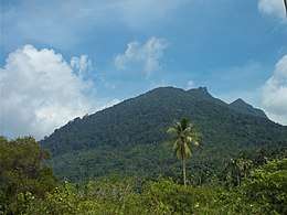 Mount Ranai in Natuna Regency | |
 Seal | |
| Motto(s): Malay: Laut Sakti Rantau Bertuah | |
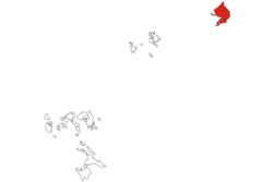 Location within Riau Islands | |
 Natuna Regency 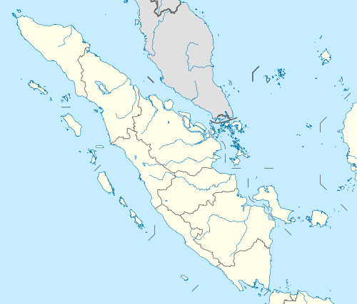 Natuna Regency Natuna Regency (Sumatra)  Natuna Regency Natuna Regency (Indonesia) | |
| Coordinates: 4°00′N 108°15′E | |
| Country | |
| Region | Sumatra |
| Province | |
| Capital | Ranai |
| Government | |
| • Regent | Abdul Hamid Rizal |
| • Vice Regent | Ngesti Yuni Suprapti |
| Area | |
| • Total | 2,008.8 km2 (775.6 sq mi) |
| Population (2019) | |
| • Total | 89,498 |
| • Density | 45/km2 (120/sq mi) |
| Time zone | UTC+7 (Indonesia Western Time) |
| Postcodes | 297xx |
| Area code | (+62) 773 |
| Website | natunakab |
The regency contains a land area of 2,008.8 km2 and had a population of 69,003 at the 2010 Census;[1] the latest official estimate (as at 2019) is 89,498.[2]
Indonesia's exclusive economic zone (EEZ) off the coast of Natuna is slightly overlapped by China's widely disputed South China Sea claim.[3]
The Natuna Islands themselves are divided into three groups:
- North Natuna, which includes Laut Island (Pulau Laut);
- Middle Natuna, which includes Bunguran (Natuna Besar), Tiga Island (Pulau Tiga) and offshore islets; and
- South Natuna, which includes the Subi Islands and Serasan.
Administration
As at 2010, the Regency was divided into twelve districts (kecamatan) – tabulated below from north to south with their areas and 2010 Census populations,[4] plus the number of administrative villages within that district (after the creation of three additional districts since 2010) and the postcode:
| Name | English name | Area in km2 | Population (2010 Census)[4] | No. of Villages | Postcode |
|---|---|---|---|---|---|
| Pulau Laut | (North Island) | 37.5 | 2,169 | 3 | 29789 |
| Bunguran Utara | (North Bunguran) | 402.6 | 3,817 | 8 | 29775 |
| Bunguran Timur Laut | (Northeast Bunguran) | 233.9 | 4,306 | 7 | 29776 |
| Bunguran Tengah | (Central Bunguran) | 171.9 | 2,834 | 3 | 29778 |
| Bunguran Timur | (East Bunguran) | 145.8 | 22,800 | 6 | 29777 |
| Bunguran Barat | (West Bunguran) | 444.8 | 10,893 | 5 | 29782 |
| Bunguran Selatan | (South Bunguran) | 232.1 | 2,537 | 4 | 29783 |
| Pulau Tiga | (Tiga Island) | 67.5 | 4,826 | 6 | 29788 |
| Midai | (Midai Island) | 26.9 | 5,007 | 3 | 29784 |
| Subi | (Subi Islands) | 155.8 | 2,577 | 8 | 29779 |
| Serasan | (West Serasan) | 45.9 | 4,506 | 7 | 29781 |
| Serasan Timur | (East Serasan) | 45.9 | 2,731 | 4 | 29780 |
Since 2010, three additional districts have been created from parts of existing districts. These are Bunguran Batubi (with five villages), Pulau Tiga Barat (West Tiga Island, with four villages) and Suak Midai (with three villages).
Maritime administration and Chinese claim
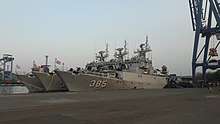
Indonesia's EEZ extends 200 nautical miles (370 km) from its shores, which around Natuna means it is slightly intersected by China's Nine-Dash Line, defining its widely disputed claim to most of the South China Sea. In 2014–2015, the presence of the Indonesian National Armed Forces on the islands was reinforced, which the Indonesian government hoped would reduce the chance of any conflict.[3] Then from late 2019, Chinese fishing vessels increased illegal activity within the EEZ, escorted by a Chinese Coast Guard vessel. Indonesia responded with a formal diplomatic protest to Beijing[5] and then deployed to the region a further 600 troops and eight navy warships, along with aerial support. The naval presence included Ahmad Yani-class frigates, Bung Tomo-class corvettes, and Kapitan Pattimura-class ASW corvettes, while aerial support came from Naval Aviation CN-235 MPA aircraft, four Indonesian Air Force F-16s and a Boeing 737-2x9, with BAE Hawk aircraft nearby on alert. A visit to the area by President Joko Widodo in early January reinforced Indonesia's resolve not to tolerate such incursions.[6]
Demographics
Peoples
According to statistics released in 2010, the population of the islands stood at 69,003 people. 85.27% of the inhabitants were Malays, with the remainder consisting of Javanese, Sumatrans and Chinese. By January 2014, the population was officially estimated to be 83,498 and by mid 2019 this had grown to 89,498.
Religion
Islam is the dominant religion in the islands[8], with 96.97% of the total population identify themselves as Muslim. Other religions are Christianity, which forms 1.66% of the total population, Buddhism, which forms 1.23% of the total population, and Confucianism, which forms 0.14% of the total population.
Economy
Despite important natural gas reserves, most of the locals work as fishermen or farmers. There is no significant tourism industry. Farming is not on an industrial scale, just small holdings. The other main source of income is gained by people working for the government.
Geography
.jpg)

The Natuna Islands are a 272-island archipelago of Indonesia, located in the Natuna Sea[9][10] between Peninsular Malaysia to the west and Borneo to the east. They extend in a NNW direction for 300 km from Tanjung Api, the northwest extremity of Kalimantan/Borneo. The Natuna Sea itself is a section of the South China Sea.
The North Group consists of a large island (Pulau Laut), two small islands and several adjacent islets and reefs which lie about 50 km NNW of Natuna Besar Island. Pulau Laut is about 11 km long with a greatest width of 5 km towards the south; it is generally hilly, rising to 273 metres near its north end.
The Middle Group consists of Natuna Besar or Bunguran Island, which contains the bulk of the area and population of the archipelago, together with small offshore islets and reefs; the Bodas Islands (Kepulauan Bodas) are a group of moderately high wooded islands lying close to the southwest coast of Natuna Besar.
The Southern Group (Kepulauan Natuna Selatan) consists primarily of two groups of islands separated from the coast of Kalimantan by the Api Passage. The Subi Islands (Kepulauan Subi) of which the main islands are Subi Besar, Subi Kecil, Bakau, Panjang and Seraya, lie southeast of Natuna Besar. Serasan Island (Pulau Serasan) is the largest of the islands lying further to the southeast and nearer to Kalimantan.
Natural resources
Natuna has large reserves of natural gas (estimated to 1.3 billion m3) that is exported to neighbouring countries such as Singapore. Matak Island now serves as an offshore exploitation base.
Ecology
The Natuna Islands are part of the Borneo lowland rain forests ecoregion.[11]
The Natuna Islands have a remarkable avifauna with 71 species of bird registered, including the near-threatened lesser fish eagle, the Natuna serpent-eagle. Other endangered species include the green iora, the brown fulvetta or the green broadbill.[12]
Colourful coral reefs are found in the neighbouring waters. The Natuna banded leaf monkey, Presbytis natunae, is among[13] the 25 most endangered primates on Earth.
Transportation
Harbours and airports
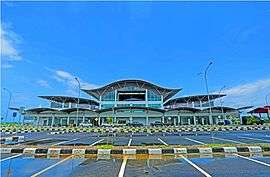
Raden Sadjad Airport or Natuna Airport is located at Ranai, the capital city of Natuna Regency. The airport is also a Type B airbase of the Indonesian Air Force.[14] Other than that, the airport also serves civilian flights. The airport also accommodate large military aircraft.[15]
A new passenger terminal opened in October 2016, inaugurated by President Joko Widodo.[16][17]
See also
- Anambas Islands
- Badas Islands
- Tambelan archipelago
References
- Biro Pusat Statistik, Jakarta, 2011.
- Badan Pusat Statistik, Jakarta, 2019.
- The sleepy island Indonesia is guarding from China, BBC News, Karishma Vaswani, 19 October 2014
- Biro Pusat Statistik, Jakarta, 2011.
- Indonesia issues protest to Beijing over Chinese vessel trespassing in Natuna, Jakarta Post, 31 December 2019
- Indonesia deploys warships, jets amid China spat, RTHK, 9 Jan 2020
- "Riau Islands Province in Figures 2017". BPS Kepulauan Riau. Retrieved 22 July 2018.
- The Natuna Islands: Geographically Malaysian, politically Indonesian, mstar.com.my. 7 December 2013 (in Malay)
- "Natuna Islands: Indonesia says no 'overlapping' South China Sea claims with China". ABC News.
- "South China Sea: Indonesia renames part of maritime economic zone in defiance of Beijing". ABC News.
- "Ecoregions 2017" interactive map. Resolve 2017.
- "Natuna Islands bird checklist - Bird Checklists of the World". Avibase. 10 August 2019. Retrieved 30 October 2019.
- Martjan Lammertink, Vincent Nijman and Utami Setiorini, "Population size, Red List status and conservation of the Natuna leaf monkey Presbytis natunae endemic to the island of Bunguran, Indonesia." Oryx / Volume 37 / Issue 04 / October 2003, pp 472 – 479
- "Kenaikan Tipe Lanud Natuna, untuk Jawab Tantangan • JakartaGreater". 13 January 2016. Retrieved 8 February 2017.
- COM, Serantau News dot. "Pesawat Tempur Mulai Disiagakan di Lanud Ranai". Archived from the original on 17 August 2016. Retrieved 8 February 2017.
- Presiden Jokowi Resmikan Terminal Bandara Ranai di Pulau Natuna
- "Jokowi Resmikan Terminal Bandara Ranai Natuna". Retrieved 8 February 2017.
Further reading
- National Geospatial Intelligence Agency (2005) "Borneo: Northwest Coast and Kepulauan Tudjuh" Sailing directions (enroute): Borneo, Jawa, Sulawesi, and Nusa Tenggara United States National Geospatial-Intelligence Agency
- The Natuna Islands: Geographically Malaysian, politically Indonesian (In English)
External links
| Wikimedia Commons has media related to Natuna Regency. |
Main islands of Riau Islands | ||
|---|---|---|
| Riau Archipelago |
| |
| Natuna Islands |
| |
| Anambas Islands |
| |
| Lingga Islands | ||
Regencies and cities of Riau Islands | ||
|---|---|---|
Capital: Tanjung Pinang | ||
| Regencies | ||
| Cities | ||
| Authority control |
|
|---|