List of maritime features in the Spratly Islands
This page features a series of lists of maritime features in the Spratly Islands:
- Features by area
- Features by major reef / bank / etc.
- Features by name
- Features by occupier and/or claimant
Features by area
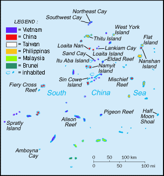
Of the hundreds of maritime features in the Spratly Islands, relatively few have land permanently above sea-level that is larger than protruding rocks. There are only 13 islands and cays with a natural area above sea-level larger than one hectare.[1] With the exception of Swallow Reef, prior to 2014 there had been no large-scale land reclamation beyond building breakwaters and piers, and extending runways.
This changed dramatically in 2014 with the PRC embarking on large-scale reclamations of the lagoons of Johnson South Reef (~10ha) and Fiery Cross Reef (~230ha), and other reclamations of then unknown extent at the Gaven Reefs and Cuarteron Reef.[2] Reports of the extent of land reclaimed on Swallow Reef vary. The PRC land reclamations have continued on a total of seven sites. In 2015, Subi Reef, Hughes Reef and Mischief Reef were added.[3] Refer to the table below for the most recently available data. In summary, there have been reclamations of very large areas (>640 acres = 1 sq mile) at three sites by the PRC, reclamations of large areas (10-100 acres) at 8 sites (4 by PRC, 3 by Vietnam and 1 by Malaysia) and reclamations of lesser areas at a number of sites. There does not appear to have been any reclamation of Philippine occupied areas. There have been small Taiwanese reclamations at Itu Aba, very small but functionally significant reclamations at six Malaysian sites, and a number small but significant reclamations at Vietnamese sites in 2016, most particularly at Spratly Island where the runway has been extended and a sheltered harbour added.
The following table contains the 16 largest "natural" features, (i.e. not including reclaimed land),[4] plus the features with significant amounts of reclaimed land:
| # | Feature | in Atoll | "Natural" Area | Location | Currently occupied by | Reclaimed Area[2] |
|---|---|---|---|---|---|---|
| 1 | Itu Aba Island | Tizard Bank | 46.00 hectares (113.7 acres) | 10°23′N 114°21′E | ROC (Taiping Island) | ~8 acres (3.2 ha)[5] |
| 2 | Thitu Island | Thitu Reefs | 37.20 hectares (91.9 acres) | 11°03′N 114°17′E | Philippines (Pagasa Island) | |
| 3 | West York Island | West York Island | 18.60 hectares (46.0 acres) | 11°05′N 115°01′E | Philippines (Likas Island) | |
| 4 | Spratly Island | Spratly Island | 13.00 hectares (32.1 acres) | 08°38′N 111°55′E | Vietnam (Trường Sa Island) | ~37 acres (15 ha)[6] |
| 5 | Northeast Cay | North Danger Reef | 12.70 hectares (31.4 acres) | 11°28′N 114°21′E | Philippines (Parola Island) | |
| 6 | Southwest Cay | North Danger Reef | 12.00 hectares (29.7 acres) | 11°26′N 114°20′E | Vietnam (Song Tử Tây Island) | ~7 acres (2.8 ha)[7] |
| 7 | Sin Cowe Island | Union Banks | 08.00 hectares (19.8 acres) | 09°52′N 114°19′E | Vietnam (Sinh Tồn Island) | ~26 acres (11 ha)[8] |
| 8 | Nanshan Island | Loaita Bank | 07.93 hectares (19.6 acres) | 10°45′N 115°49′E | Philippines (Lawak Island) | |
| 9 | Sand Cay | Tizard Bank | 07.00 hectares (17.3 acres) | 10°23′N 114°28′E | Vietnam (Sơn Ca Island) | ~9 acres (3.6 ha)[9][10] |
| 10 | Loaita Island | Loaita Bank | 06.45 hectares (15.9 acres) | 10°40′N 114°25′E | Philippines (Kota Island) | |
| 11 | Swallow Reef | Swallow Reef | 06.20 hectares (15.3 acres) | 07°22′N 113°50′E | Malaysia (Layang-Layang Reef) | ~95 acres (38 ha) |
| 12 | Namyit Island | Tizard Bank | 05.30 hectares (13.1 acres) | 10°11′N 114°22′E | Vietnam (Nam Yết Island) | |
| 13 | Amboyna Cay | Amboyna Cay | 01.60 hectares (4.0 acres) | 07°54′N 112°55′E | Vietnam (An Bang Island) | |
| Grierson Reef | Union Banks | 01.60 hectares (4.0 acres) | 09°54′N 114°34′E | Vietnam (Sinh Tồn Đông Island) | ~3 acres (1.2 ha)[11][12] | |
| West (London) Reef | London Reefs | 01.10 hectares (2.7 acres) | 08°52′N 112°15′E | Vietnam (Đá Tây A Island) | ~70 acres (28 ha)[9][11][12][13] | |
| Central (London) Reef | London Reefs | 00.88 hectares (2.2 acres) | 08°56′N 112°21′E | Vietnam (Trường Sa Đông Island) | ~4 acres (1.6 ha)[11][12] | |
| 14 | Flat Island | Loaita Bank | 00.57 hectares (1.4 acres) | 10°49′N 115°49′E | Philippines (Patag Island) | |
| 15 | Loaita Cay | Loaita Bank | 00.53 hectares (1.3 acres) | 10°43′43″N 114°21′09″E | Philippines (Melchora Aquino Island) | |
| 16 | Lankiam Cay | Loaita Bank | 00.44 hectares (1.1 acres) | 10°43′N 114°32′E | Philippines (Panata Island) | |
| Mischief Reef | Mischief Reef | 00.00 | 09°56′N 115°32′E | PRC | ~1,379 acres (558 ha)[14][15] | |
| Subi Reef | Thitu Reefs | 00.00 | 10°55′N 114°04′E | PRC | ~976 acres (395 ha)[14][16] | |
| Fiery Cross Reef | Fiery Cross Reef | 00.00 | 09°36′N 111°57′E | PRC | ~677 acres (274 ha)[14][17] | |
| Cuarteron Reef | London Reefs | 00.00 | 08°52′N 112°50′E | PRC | ~56 acres (23 ha)[18] | |
| Gaven Reefs | Tizard Bank | 00.00 | 10°13′N 114°13′E | PRC | ~34 acres (14 ha)[19] | |
| Johnson South Reef | Union Banks | 00.00 | 09°43′N 114°17′E | PRC | ~27 acres (11 ha)[20] | |
| Hughes Reef | Union Banks | 00.00 | 09°55′N 114°30′E | PRC | ~19 acres (7.7 ha)[21][22] | |
| Pearson Reef | SW Dangerous Ground | 00.00 | 08°58′N 113°42′E | Vietnam (Phan Vinh Island) | ~6 acres (2.4 ha)[23] | |
| Cornwallis South Reef | SW Dangerous Ground | 00.00 | 08°43′N 114°11′E | Vietnam (Núi Le Reef) | ~2 acres (0.81 ha)[11][12] |
Features by major reef / bank / etc.
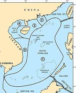
The boundaries of the Spratly Islands are not firmly defined. West-to-east, the islands range from the coastal waters of Vietnam to the east of Dangerous Ground and the Palawan Passage (approx. 106-117°E), and south-to-north from the coastal waters of Borneo and the southern South China Sea to the north of Dangerous Ground and the Reed Bank (approx. 3-12°N).
The major feature of the area is Dangerous Ground, an oblong area approximately 340 nautical miles (630 km; 390 mi) SW-NE, 175 nautical miles (324 km; 201 mi) at its widest, with an area of about 52,000 nm² (178,000 km²).[24] It lies approximately between 7.5–12°N, 113–117°E, and US NGA literature[24][25][26]etc. seems to consider its centre as 10°N 115°E. The remainder of the Spratly Islands are mainly to the west and south of Dangerous Ground, with some features to the east.
The Spratly Islands can be roughly divided into seven sub-areas relative to Dangerous Ground:[24]
- NW of Dangerous Ground (approx. 10-12°N, 113-115°E)[25]
- NE Dangerous Ground (approx. 10-12°N, 115-117°E)[26]
- SE Dangerous Ground (approx. 7-10°N, 115-117°E)[27][28][29]
- SW Dangerous Ground (approx. 7-10°N, 113-115°E)[30]
- E of Dangerous Ground (approx. 3-12°N, east of 117°E)[26][27][29]
- S of Dangerous Ground (approx. 3- 7°N, 113-117°E)[29][31] and
- W of Dangerous Ground (approx. 3-12°N, west of 113°E)[32]
Within these sub-areas there are a number of major reefs and banks, as well as ungrouped maritime features.[4]
Starting in the NW, and progressing in a generally SW direction, the features include:
| Sub-area | Group | Vicinity | Contains: |
|---|---|---|---|
| NW | North Danger Reef | 11°25′N 114°21′E | North Reef; Northeast Cay; Shira Islet; Southwest Cay; Jenkins Patches; South Reef; Sabine Patches; Farquharson Patches; Day Shoal; Iroquois Ridge |
| NW | Trident & Lys | Trident Shoal, Lys Shoal | |
| NW | Thitu Reefs | 11°03′N 114°17′E | Thitu Island; Thitu Reef; Sandy Cay |
| NW | (Near Thitu Reefs) | 10°55′N 114°04′E | Subi Reef |
| NW | Loaita Banks | 10°45′N 114°30′E | Lankiam Cay; Loaita Cay; Loaita Nan; Loaita Island |
| NW | (East of Loaita Banks) | 10°55′N 114°45′E | Menzies Reef, Irving Reef, West York Island |
| NW | Tizard Banks | 10°15′N 114°30′E | Ban Than Reef (Zhongzhou); Eldad Reef; Gaven Reefs; Namyit Island; Petley Reef; Sand Cay; Taiping Island (Itu Aba) |
| NW | (West of Tizard Bank) | Western Reef, Discovery Great Reef, Discovery Small Reef | |
| W | (West of Union Bank) | 9°30′N 112°30′E | Fiery Cross Reef, Dhaulle Reef, Coronation Bank |
| SW | Union Banks | 09°50′N 114°30′E | Collins Reef (Johnson North); Edmund Reef; Empire Reef; Grierson Reef; Hallett Reef; Higgins Reef; Holiday Reef; Hughes Reef; Johnson South Reef; Jones Reef; Lansdowne / Landsdown / etc. Reef; Loveless Reef; Kennan / McKennan Reef; Sin Cowe Island; Sin Cowe East; Whitson Reef; Zhangxi Jiao |
| NE | Reed Tablemount | 11°20′N 116°50′E | Reed Bank; Nares Bank; Marie Louise Bank |
| NE | NE Dangerous Ground | 11°N 116°E | Jackson Atoll, Nanshan Island, Flat Island, Third Thomas Shoal, Hopkins Reef, Amy Douglas, Hirane Shoal, Hardy Reef, Sandy Shoal, Lord Auckland Shoal, Carnatic Shoal |
| NE | Southampton Reefs | Hopps Reef; Livock Reef | |
| E | (East & SE of Dangerous Ground) | Seahorse Shoal/Seashore Shoal/Routh Shoal, Bombay Shoal, Royal Captain Shoal, Half Moon Shoal, Viper Shoal | |
| SE | SE Dangerous Ground | 9°N 116°E | Sabina Shoal, Boxall Reef, Second Thomas Shoal, Mischief Reef, First Thomas Shoal, Alicia Annie Reef, Commodore Reef, North Viper Shoal, Northeast Shea, Director Reef, Glasgow Bank, Investigator Northeast Shoal, Sand Cay |
| SW | SW Dangerous Ground | 9°N 114°E | Bittern Reef, Allison Reef, Cornwallis South Reef, Pearson Reef, Pigeon Reef, Investigator Shoal, Ardasier Reef, Ardasier Bank, Erica Reef, Mariveles Reef, Dallas Reef, Barque Canada Reef |
| W | London Reefs | 08°50′N 112°30′E | Central London Reef; Cuarteron Reef; East London Reef; West London Reef |
| W | (Spratly Island vicinity) | 08°40′N 111°45′E | Spratly Island, Ladd Reef, Jubilee Seamount |
| W | (West Spratlys) | Scawfell Shoal, Charlotte Bank, Vanguard Bank, Julia Shoal, Royal Bishop Shoal | |
| W | Southwest Bank | Alexandra Bank; Grainger Bank; Prince of Wales Bank; Prince Consort Bank | |
| W | Rifleman Bank | 07°50′N 111°40′E | Bombay Castle (bãi Ba Kè); Johnson Patch (tức là Bãi Vũng Mây); Kingston Shoal (Bãi Đinh); Orleana Shoal (Bãi Đất), Bãi Ráng Chiều, bãi Ngũ Sắc, bãi Xà Cừ, bãi Vũ Tích |
| S | Amboyna Cay; Swallow Reef; Louisa Reef | ||
| S | Luconia Shoals | 05°30′N 112°30′E | North Luconia Shoals: Friendship Shoal, Hardie Reef, Aitken Reef, Buck Reef, Moody Reef, Seahorse Breakers, Tripp Reef, Hayes Reef South Luconia Shoals: Stigant Reef, Connell Reef, Herald Reef, Comus Shoal, Richmond Reef, Luconia Breakers |
Features by name
- A
- Amboyna Cay
- Ardasier Reef
- Ayungin Reef / shoal (Second Thomas)
- B
- Balagtas Reef (Irving Reef)
- Ban Than Reef (Zhongzhou Reef)
- Boji Jiao (Erica Reef)
- Bombay Castle
- C
- Calderon Reef (Cuarteron Reef)
- Celerio Reef (Swallow Reef)
- Central (London) Reef
- Chigua Reef (Johnson South Reef)
- Collins Reef (Johnson North Reef)
- Cuarteron Reef
- D
- Dallas Reef
- Dangerous Ground
- Dongmen Reef (Hughes Reef)
- E
- East London Reef
- Enola Reef / Erica Reef
- F
- Fiery Cross Reef
- Flat Island
- First Thomas Reef
- G
- Gabriela Silang Reef (Erica Reef)
- Gaven Reefs / Gaven North Reef / Gaven South Reef
- H
- I
- Investigator Shoal
- Irving Reef
- Itu Aba
- J
- James Shoal
- Johnson Reef:
- Johnson North Reef (Collins)
- Johnson South Reef (Chigua)
- K
- Kalayaan Islands / Kalayaan, Palawan
- Kota Island (Loaita)
- L
- Ladd Reef
- Lankiam Cay
- Lawak Island (Nanshan Island)
- Layang Layang / Layang Layang Island (Swallow)
- Ligao Island (Itu Aba)
- Likas Island (West York)
- Loaita Cay / Loaita Nan / Loaita Island
- London Reefs
- Louisa Reef
- Luconia Shoals
- M
- Mariveles Reef
- Menzies Reef
- Mischief Reef
- Republic of Morac-Songhrati-Meads
- N
- P
- Pagasa Island (Thitu)
- Panata Island (Lankiam)
- Panganiban Reef (Mischief)
- Parola Island (Northeast Cay)
- Patag Island (Flat Is)
- Pawikan Reef (Investigator)
- Pugad Island (Southwest Cay)
- R
- Recto Bank / Reed Bank / Reed Tablemount
- S
- Sabina Shoal
- Sand Cay
- Second Thomas Reef / Second Thomas Shoal
- Sin Cowe Island
- Southwest Cay
- Spratly Island / Storm Island
- Subi Reef
- Swallow Reef
- T
- Taiping Island (Itu Aba)
- Terumbu Siput (Erica)
- Thitu Island
- Third Thomas Shoal
- U
- Union banks
- W
- Z
Features by occupier and/or claimant
A feature is occupied by a country if one of the following is true:
- Soldiers and/or civilian citizens of a country are present in the feature, either by building structures over the feature to house the citizens (most features are of this type) or by manning a ship anchored over the feature (Philippine-occupied Irving Reef is of this type).
- Regularly visited by soldiers of a country, not necessarily having soldiers present in it 24 hours. These features must lie near (within 9 miles (14 km)) a feature occupied by the country in the way of the first condition. Presence of structures is not necessary. This is the case of Philippine-occupied Flat Island and Lankiam Cay where soldiers stationed at Nanshan Island and Loaita Island respectively, regularly visit on a daily basis.
The effective visible distance of horizon from a 15-meter (typical large structure) height above sea-level is 9 miles (14 km). This makes features occupied by the second condition to be also labeled as "occupied" since they can be guarded far away. However, not all features within the 9-mile (14 km) radius can be considered as absolutely occupied. This is especially true for features that lie between and within 9 miles (14 km) of two or more features occupied by different countries. (See Virtually Occupied or Controlled table)
Summary
| Int'l Name | Co-ords | Sub-group | Occupant/s | Since | Notes |
|---|---|---|---|---|---|
| Itu Aba | 10°22′N 114°22′E | Tizard Bank | ROC (Taiwan) | 1946 | |
| Ban Than Reef | 10°23′N 114°24′E | Tizard Bank | ROC (Taiwan) | 1946 | |
| Cuarteron Reef | 08°53′N 112°51′E | London Reefs | PRC (China) | 1988 | |
| Fiery Cross Reef | 09°37′N 112°58′E | W of Union Banks | PRC (China) | 1988 | Military Garrison |
| Gaven Reefs | 10°13′N 114°13′E | Tizard Bank | PRC (China) | 1988 | |
| Hughes Reef | 09°55′N 114°30′E | Union Banks | PRC (China) | 1988 | Lighthouse |
| Johnson South Reef | 09°42′N 114°15′E | Union Banks | PRC (China) | 1988 | |
| Mischief Reef | 09°55′N 115°32′E | SE Dangerous Ground | PRC (China) | 1995 | Airfield |
| Subi Reef | 10°55′N 114°04′E | W of Thitu Reefs | PRC (China) | 2013 | Military Garrison |
| First Thomas Shoal | 09°19′N 115°57′E | SE of Mischief Reef | - | - | |
| Whitson Reef | 10°00′N 114°42′E | Union Banks | - | - | |
| Flat Island | 10°49′N 115°49′E | SE Dangerous Ground | PH | 1974 | |
| Lankiam Cay | 10°43′N 114°32′E | Loaita Banks | PH | - | |
| Loaita Cay | 10°43′43″N 114°21′09″E | Loaita Banks | PH | - | |
| Loaita Island | 10°40′N 114°25′E | Loaita Banks | PH | - | |
| Nanshan Island | 10°45′N 115°49′E | Loaita Banks | PH | - | |
| Northeast Cay | 11°28′N 114°21′E | North Danger Reef | PH | - | |
| Thitu Island | 11°03′N 114°17′E | Thitu Reefs | PH | - | |
| West York Island | 11°05′N 115°01′E | NNW Dangerous Ground | PH | - | |
| Commodore Reef | 11°05′N 115°01′E | PH | - | ||
| Irving Reef | 10°52′N 114°55′E | NNW Dangerous Ground | PH | - | |
| Second Thomas Shoal | 09°44′N 115°52′E | NE Dangerous Ground | PH | 2012 | Navy Outpost |
| Amboyna Cay | 07°54′N 112°55′E | Viet | - | Lighthouse | |
| Namyit Island | 10°11′N 114°22′E | Tizard Bank | Viet | 1975 | Lighthouse |
| Sand Cay | 10°23′N 114°29′E | Tizard Bank | Viet | 1974 | Lighthouse |
| Sin Cowe Island | 09°52′N 114°19′E | Union Banks | Viet | 1974 | Lighthouse |
| Southwest Cay | 11°28′N 114°21′E | North Danger Reef | Viet | 1975 | Lighthouse |
| Spratly Island | 08°38′N 114°25′E | Viet | 1974 | Lighthouse | |
| Alison Reef | 08°51′N 114°00′E | Viet | - | ||
| Barque Canada Reef | 08°10′N 113°18′E | Viet | 1987 | ||
| Central London Reef | 08°56′N 112°21′E | London Reefs | Viet | 1978 | |
| Collins Reef | 09°46′N 114°15′E | Union Banks | Viet | - | |
| Cornwallis South Reef | 08°43′N 114°11′E | Viet | 1988 | ||
| Discovery Great Reef | 10°04′N 113°51′E | Viet | 1988 | ||
| East London Reef | 08°50′N 112°36′E | London Reefs | Viet | 1988 | |
| Grierson Reef | 09°54′N 114°34′E | Viet | - | ||
| Higgens Reef | 09°48′N 114°24′E | Union Banks | Viet | - | |
| Ladd Reef | 08°41′N 111°40′E | Viet | 1988 | Lighthouse | |
| Landsdowne Reef | 09°47′N 114°22′E | Viet | - | ||
| Pearson Reef | 08°57′N 113°40′E | Viet | 1988 | ||
| Petley Reef | 10°24′N 114°35′E | Tizard Bank | Viet | 1988 | |
| Pigeon Reef | 08°51′N 114°39′E | Viet | 1988 | Lighthouse | |
| South Reef | 11°23′N 114°18′E | Viet | 1988 | ||
| West London Reef | 08°52′N 112°14′E | London Reefs | Viet | 1988 | Lighthouse |
| Bombay Castle | 07°56′N 111°43′E | Rifleman Bank | Viet | 1989 | Lighthouse |
| Prince of Wales Bank | 08°09′N 110°36′E | Southwest Bank | Viet | 1989 | Lighthouse |
| Grainger Bank | 07°49′N 110°30′E | Southwest Bank | Viet | 1991 | Lighthouse |
| Alexandra Bank | 08°01′N 110°38′E | Southwest Bank | Viet | 1991 | Lighthouse |
| Prince Consort Bank | 07°55′N 109°58′E | Southwest Bank | Viet | 1990 | Lighthouse |
| Vanguard Bank | 07°32′N 109°45′E | West Spratlys | Viet | 1989 | Lighthouse |
| Swallow Reef | 07°22′N 113°50′E | Mysia | 1983 | RMN offshore EEZ station "Lima" | |
| Ardasier Reef | 07°38′N 113°56′E | Mysia | 1986 | RMN offshore EEZ station "Uniform" | |
| Dallas Reef | 07°37′N 113°48′E | Mysia | 1987 (or 1986) | ||
| Erica Reef | 08°06′N 114°08′E | Mysia | 1999 | RMN offshore EEZ station "Sierra" | |
| Investigator Shoal | 08°07′N 114°42′E | Mysia | 1999 | RMN offshore EEZ station "Papa" | |
| Louisa Reef | 06°20′N 113°14′E | Mysia | - | ||
| Mariveles Reef | 08°00′N 113°54′E | Mysia | 1986 | RMN offshore EEZ station "Mike" | |
| Loaita Cay | |||||
| Loaita Nan | |||||
| North Reef | |||||
| Sandy Cay | |||||
| McKennan Reef | |||||
| Edmund Reef | |||||
| Hallet Reef | |||||
| Holiday Reef | |||||
| Empire Reef | |||||
| Eldad Reef | |||||
| Amy Douglas Bank | |||||
| Bombay Shoal | 9°26′N 116°55′E | ||||
| Boxall Reef | 8°51′N 114°00′E | ||||
| Carnadic Shoal | |||||
| Director Shoal | |||||
| Ganges Reef | |||||
| Glasgow Bank | |||||
| Half Moon Shoal | |||||
| Hardy Reef | |||||
| Hopkins Reef | |||||
| Investigator Northeast Shoal | |||||
| Iroquois Reef | |||||
| Leslie Bank | |||||
| Lord Auckland | |||||
| Lys Shoal | |||||
| North East Shea | |||||
| Pennsylvania North Reef | |||||
| Pennsylvania South Reef | |||||
| Reed Tablemount | |||||
| Nares Bank | |||||
| Marie Louise Bank | |||||
| Royal Captain Shoal | |||||
| Sabina Shoal | |||||
| Sandy Shoal | |||||
| Seahorse Shoal | |||||
| Stag Shoal | |||||
| Southern Bank | |||||
| Magat Salamat | |||||
| Tagpi | |||||
| Hubo Reef | |||||
| Katimugan Banks | |||||
| Templar Bank | |||||
| Trident Shoal | |||||
| Viper North Shoal | |||||
| Viper Shoal | |||||
| North Luconia Shoals | |||||
| South Luconia Shoals | |||||
| James Shoal | |||||
| Alicia Annie Reef | |||||
| Coronation Bank | |||||
| Discovery Small Reef | |||||
| Dhaulle Shoal | |||||
| Hopps Reef | |||||
| Jackson Atoll | |||||
| Jones Reef | |||||
| Livock Reef | |||||
| Menzies Reef | |||||
| Owen Shoal | |||||
| Thitu Reef |
Occupied features
Republic of China (Taiwan)
| Int'l Name | Local Names | Description | Area (ha.) | Reclaimed area |
| Taiping Island / Itu Aba[4][33] | 10°22′30″N 114°22′0″E - Part of Tizard Banks. The largest of the Spratly islands, and one of the few islands in the South China Sea with its own source of fresh water. Located about 22 miles (35 km) south-southwest of Philippine-occupied Loaita (Kota) Island and about 6 miles (10 km) west of Vietnam-occupied Sand Cay. Covered with shrubs, coconut and mangroves. 600 soldiers stationed, lighthouse,[34] radio and weather stations, concrete landing jetty and two wells at the SW end. Guano deposits, fringing reef. Hainan fishermen used to visit annually. In August 1993, plans were announced for a 2 km-long airstrip and a fishing port. The now only 1150-meters-long airstrip was completed in January 2008.[35] Pineapple was once cultivated here. Occupied since September 1956, four months after Filipino Tomas Cloma claimed the islands. |
46 | ||
| Other names: | Ligao, Huángshānmǎ Jiāo (黃山馬礁), Huángshānmǎ Zhì (黃山馬峙), Nagashima (長島) | |||
| Ban Than Reef / Zhongzhou Reef[4] | 10°23′10″N 114°24′49″E - Part of Tizard Banks. Lies 3 miles (5 km) east of Itu Aba Island and 3 miles (5 km) west of Vietnamese occupied Sand Cay. Small drying reef.[4] "Construction project" underway since March 1995.[37] |
0 | ||
| Total | 1 island, 1 reef | 46 |
People's Republic of China
| Int'l Name | Local Names | Description | Area (ha.) | Reclaimed area |
| Cuarteron Reef[4][33] | 8°53′00″N 112°51′05″E - Part of London Reefs. Natural features |
0 | 23.1 ha[39] | |
| Fiery Cross Reef / Northwest Investigator Reef[4][33] | 9°37′N 112°58′E - West of Union Banks Natural features |
0 | 274 ha[39] | |
| Gaven Reefs[4][33] | (Southern reef) |
10°12′48″N 114°13′9″E - Part of Tizard Banks. Natural features |
0 | 13.6 ha[39] |
| Hughes Reef[4][33] | 9°55′N 114°30′E - Part of Union Banks. Natural features |
0 | 7.6 ha[39] | |
| Johnson South Reef[4][33] | 9.71389°N 114.286°E - Part of Union Banks. Natural features |
0 | 10.9 ha[39] | |
| Mischief Reef[4][33] | 9°55′N 115°32′E - East of the centre of Dangerous Ground. Natural features |
0 | 558 ha[39] | |
| Subi (Zhubi) Reef [4][33] | 10°54′48″N 114°03′43″E - West of Thitu Reefs. Natural features |
0 | 395 ha[45] | |
| First Thomas Shoal |
|
9°19′N 115°57′E - SE of Mischief Reef A few rocks are permanently above sea level. Much of the reef is above water at low tide. Encloses a lagoon. |
0 | |
| Whitson Reef[4] | Part of Union Banks. Some rocks naturally above water at high tide. Part of Union Banks. |
0 | ||
| Total | 9 reefs of which 7 have artificial islands | 0 | 1350.6 ha |
Republic of the Philippines
| Int'l Name | Local Names | Description | Area (ha.) | Reclaimed area |
| Flat Island[33][4] | 10°49′00″N 115°49′20″E The fourteenth largest Spratly island. About 6 miles (10 km) southwest of Philippine-occupied Lawak Island (Nanshan Island). It changes its shape seasonally; the sand build up depends largely on the direction of prevailing wind and waves - the island has taken an elongated shape, the shape of a crescent moon, and the shape of a letter "S". Like Panata Island (Lankiam Cay), it is also barren of any vegetation. No underground water source is found in the island. Presently, the island serves as a military observation post for the Municipality of Kalayaan. A low, flat, sandy cay, 240m by 90m, subject to erosion. No vegetation. Several soldiers stationed. |
0.57 | ||
| ||||
| Lankiam Cay[4][33] | The sixteenth largest and the smallest Spratly island. Located 8 miles (13 km) northeast of Philippine-occupied Kota Island (Lankiam Cay). A few years ago this island has a surface area of more than 5 hectares but strong waves brought by a strong typhoon washed out the sandy surface (beach) of the island leaving behind today the calcarenite foundation that can be seen at low tide. Several soldiers stationed. Part of Loaita Banks. | 0.44 | ||
| ||||
| Loaita Cay[4][33] | The fifteenth largest Spratly island. It's located about 5 nautical miles (9.3 km; 5.8 mi) northwest of Philippine-occupied Loaita Island, just west of the north of Dangerous Ground. The island is a low, flat, sandy cay, and is subject to erosion. It changes its shape seasonally. The sand build up depends largely on the direction of prevailing winds and waves; it has taken an elongated shape for some years. Several soldiers stationed. Occupied since 1968. Part of Loaita Banks. | 0.53 | ||
| ||||
| Loaita Island[4][33] | The tenth largest Spratly island. Located 22 miles (35 km) southeast of Philippine-occupied Pag-asa Island (Thitu Island) and 22 miles (35 km) north-northeast of the ROC-occupied Taiping Island. It fringes the Laoita bank and reef. Its calcarenite outcrop is visible along its western side at low tide. The present shape of the island indicates sand buildup along its eastern side. The anchor-shaped side will eventually connect with the northern portion as the sand buildup continues thereby creating another mini-lagoon in the process. The presence of migrating sea birds adds to the high phosphorus contents of the sand found in the island. Occasionally, giant sea turtles are reported to be laying their eggs in the island. Covered with mangrove bushes, above which rose coconut palms and other small trees. Several soldiers stationed. Occupied since 1968. Part of Loaita Banks. | 6.45 | ||
| ||||
| Nanshan Island[4][33] | 10°45′N 115°49′E The eighth largest Spratly island. Located 98.0 miles (157.7 km) east of Pag-asa (Thitu Island). This island is a bird sanctuary. Its surroundings are highly phosphatized that superphosphate materials can be mined out on a small-scale basis. Near the fringes of the breakwaters (approx. 2 miles (3 km) from the island), intact hard coral reefs were observed to retain their natural environment and beautiful tropical fishes were seen colonizing these coral beds of varying colors. Covered with coconut trees, bushes and grass. 580 m long, on the edge of a submerged reef. Several soldiers stationed. Has a small airstrip. |
7.93 | ||
| ||||
| Northeast Cay[4][33] | 11°28′N 114°21′E The fifth largest Spratly island. Only 1.75 miles (2.82 km) north of Vietnamese-occupied Southwest Cay and can be seen before the horizon. Located 28 miles (45 km) northwest of Philippine-occupied Pag-asa (Thitu Island). Some of its outcrops are visible on its western side. It has high salinity groundwater and vegetation limited to beach type of plants. The corals around the island were mostly destroyed by rampant use of dynamite fishing and cyanide method employed by foreign fishing boats in the past. Covered with grass and thick trees. Much of the ringing reef is above water at high tide. Supported a beacon in 1984. Has Guano deposits. Several soldiers stationed. Satellite photography suggests it may have an airstrip.[46] Occupied since 1968. Part of North Danger Reef. |
12.7 | ||
| ||||
| Thitu Island[4][33] | The second largest Spratly island. Serves as the poblacion for the Municipality of Kalayaan, Palawan, Phils. It is covered with trees and has a variety of fauna. It is home to some 300+ civilians (including children) and over 50 soldiers. Other islands are expected to be populated before 2010. Population is regulated to protect the islands' flora and fauna and to avoid tension with other countries. It has 1.4 km airstrip, a marina, water filtering plant, power generator and a commercial communications tower (by Smart Communications), school, and television channel. The Philippines' Department of Tourism is making improvements to the island to make it profitable. Occupied since 1968. Part of Thitu Reefs. | 37.2 | ||
| ||||
| West York Island[4][33] | 11°05′N 115°01′E The third largest Spratly island. This island is located 47 miles (76 km) northeast of Pag-asa (Thitu Island). Outcrops are visible on the southern and eastern portion of the island during low tides. This island is considered a sanctuary for giant sea turtles that lay their eggs on the island all year round. The high salinity of the ground water in the island retards the growth of introduced trees like coconuts, ipil-ipil, and other types. Only those endemic to the area that are mostly beach type of plants thrive and survive the hot and humid condition especially during the dry season. Has an observation post. Several soldiers stationed. |
18.6 | ||
| ||||
| Commodore Reef[4][33] | A sand "cay", 0.5 m high, surrounded by two lagoons. Parts of reef above water at high tide. It is a typical reef lying underwater and is now being manned by a military contingent based and established in the area. Some structures. Several soldiers stationed. Occupied since 1978. | 0 | ||
| ||||
| Irving Reef[4] | Naturally above water only at low tide. A very small cay lies at northern end. Some structures. Several soldiers stationed. | 0 | ||
| ||||
| Second Thomas Reef / shoal[47] | A shallow reef. It is close to Chinese-occupied Mischief Reef. It was occupied by the Philippines in 1999, after the 1995 controversial Chinese occupation of Mischief Reef, to put pressure on China not to occupy any features further which lie near the Philippines. | 0 | ||
| ||||
| Total | 8 islands, 3 reefs | 84.42 |
Socialist Republic of Vietnam
| Int'l Name | Local Names | Description | Area (ha.) | Reclaimed area |
| Amboyna Cay[4][33] | 07°54′N 112°55′E The thirteenth largest Spratly island. 2m high. Two parts: East part consists of sand and coral, west part is covered with guano. Has fringing reef. An obelisk, about 2.7 m high, stands on the SW corner. Little vegetation. Lighthouse operational since May 1995.[34] Heavily fortified.[4] |
1.6 | ||
| Namyit Island[4][33] | 10°11′N 114°22′E The twelfth largest Spratly island. Covered with small trees, bushes and grass. Has a fringing reef and is inhabited by sea birds. The island is inhabited by an unknown number of Vietnamese soldiers and in the deep waters fronting the south side it is said that a submarine base is situated. Occupied since 1975.Part of Tizard Banks. |
5.3 | ||
| Sand Cay[4][33] | 10°23′N 114°29′E The ninth largest Spratly island. Lies 6 miles (10 km) to the east of Taiwan-occupied Taiping Island. Covered with trees and bushes. Fringing reef partly above water at low tide. This feature is commonly confused with Sandy Cay. Occupied since 1974. Part of Tizard Banks. |
7 | ||
| ||||
| Sin Cowe Island[4][33] | 9°52′N 114°19′E The seventh largest. Has fringing reef which is above water at low tide. Occupied since 1974. Part of Union Banks. |
8 | ||
| Southwest Cay[4][33] | 11°28′N 114°21′E The sixth largest Spratly island. Only 1.75 miles (2.82 km) from Northeast Cay and can be seen before the horizon. Previously a breeding place for birds and covered with trees and guano. Export of guano was once carried out "on a considerable scale." Fringing reef partly above water at high tide. Vietnam erected its first lighthouse in the Spratlys here in October 1993[34] and built an airstrip. Has a three-story building, garrisoned by soldiers. Philippine military controlled the island before the early 1970s. South Vietnamese forces (Republic of Vietnam) invaded the island in 1975, when Filipino soldiers guarding the island attended the birthday party of their commanding officer based in the nearby Northeast Cay. A confirmed report came out that Vietnamese prostitutes were sent by Vietnamese officials to the birthday party, supposedly a sign of good brotherhood between the forces, but was actually used to lure the Filipino soldiers guarding the island. Filipino forces apparently planned on attacking the island, thus it would have led to a war, but Vietnamese forces were able to erect a huge garrison in the island within few weeks, forcing Filipino officials to abort the plan. Since then, more soldiers were assigned to Parola Island (North East Cay), to avoid it from happening again. This was confirmed by interviews with soldiers involved in an episode of the defunct ABS-CBN's Magandang Gabi Bayan (Good Evening Nation) program. See Policies, activities and history of the Philippines in Spratly Islands#Southwest Cay invasion for more details. Part of North Danger Reef. |
12 | ||
| ||||
| Spratly Island / Storm Island[4][33] | 8°38′N 114°25′E The fourth largest Spratly island. 2.5 m high, flat. Covered with bushes, grass, birds and guano. 5.5 m-high obelisk at southern tip. Has landing strip, and a fishing port. Fringing reef is above water at low tide. Some structures with soldiers stationed. Occupied since 1974. |
13 | ||
| Alison Reef[4][33] | 8°51′N 114°00′E Naturally above water only at low tide. Encloses a lagoon.[4] |
0 | ||
| Barque Canada Reef / Lizzie Weber Reef[4][33] | 8°10′N 113°18′E Coral. Highest rocks are 4.5 m high, at SW end. Much of reef is above water at high tide. Some sandy patches. 18 miles (29 km) long. Its military structures have been upgraded. Occupied since 1987.[4] |
0 | ||
| Central London Reef[4][33] | 08°59′N 112°21′E SW part is a sandbank which barely submerges at high tide. The rest is coral reef, awash, surrounding a lagoon. Occupied since 1978. Part of London Reefs. |
0 | ||
| Collins Reef / Johnson North Reef[4] | 09°46′N 114°15′E Lies 8 miles (13 km) southwest of Vietnam-occupied Sin Cowe Island. Connected to Johnson South Reef. A "coral dune" is located at the southeast corner, above the high tide line. Part of Union Banks. |
0 | ||
| Cornwallis South Reef[4][33] | Naturally above water only at low tide. Encloses a lagoon. Occupied since 1988. | 0 | ||
| Great Discovery Reef[4][33] | Several rocks are above water at high tide. Most of reef is above water at low tide. Has lagoon. Occupied since 1988. | 0 | ||
| East London Reef[4][33] | Rocks up to 1 m high. Encloses a lagoon. Occupied since 1988. Part of London Reefs. | 0 | ||
| Grierson Reef[4] | A sand cay with fringing reef.[48] (Despite some ambiguity in various references, this is NOT Sin Cowe East Island.[49]) Its sand bar area is about 12 hectares. Part of Union Banks. | 0 | ||
| Higgens Reef[33] | Lies 6 miles (10 km) southeast of Vietnam-occupied Sin Cowe Island. Only above water at low tide. Part of Union Banks. | 0 | ||
| Ladd Reef[33] | Naturally above water at low tide. Has coral lagoon. Occupied since 1988. | 0 | ||
| Lan(d)sdowne Reef[4][33] | Sand dune, with fringing reef. Part of Union Banks. | 0 | ||
| Pearson Reef[4][33] | Two sand "cays", 2 m and 1 m high, lie on the edges of a lagoon. Parts of the surrounding reef are above water at high tide. Occupied since 1988. | 0 | ||
| Petley Reef[4][33] | Naturally above water only at low tide, some small rocks might stand above high water. Occupied since 1988. Part of Tizard Banks. | 0 | ||
| Pigeon Reef / Tennent Reef[4][33] | Numerous rocks are naturally above the high tide line. Encloses a lagoon. Occupied since 1988. | 0 | ||
| South Reef[4][33] | Lies about 2.5 miles (4 km) southwest of Vietnam-occupied Southwest Cay. A tiny cay appears atop this reef on the most detailed map available. On the southwest end of North Danger Reef. Fringing reef is above water at low tide. Occupied since 1988. Part of North Danger Reef. | 0 | ||
| West London Reef[4][33] | East part is sand "cay", 0.6 m high. West part is coral reef which is above water only at low tide. Between them is a lagoon. Vietnam erected a lighthouse here in May or June 1994.[34] Part of London Reefs. | 0 | ||
| Rifleman Bank (containing Bombay Castle)[4] | Shallowest natural depth is 3 m, called Bombay Castle. Sand and coral. Occupied since 1989. | 0 | ||
| Prince of Wales Bank | Shallowest natural depth is 7 m. Has corals. Occupied since 1989. | 0 | ||
| Grainger Bank[4] | Shallowest natural depth is either 9 m or 11 m. Occupied since 1991. | 0 | ||
| Alexandra Bank | Shallowest natural depth is 5 m. Occupied since 1991. | 0 | ||
| Prince Consort Bank[4] | Shallowest natural depth is 9 m. Occupied since 1990. | 0 | ||
| Vanguard Bank[4] | Shallowest natural depth is 16 m. Vietnam has run three "economic technological service stations" in this area since July 1994. Occupied since 1989. | 0 | ||
| Total | 6 islands, 16 reefs, 6 banks | 46.9 |
Malaysia
Note that the Royal Malaysian Navy have established 5 Offshore naval stations (Offshore EEZ Stations) on reclaimed land:[50]
- 1983 Station Lima (Swallow Reef)
- 1986 Station Uniform (Ardasier Reef)
- 1986 Station Mike (Mariveles Reef)
- 1999 Station Sierra (Erica Reef)
- 1999 Station Papa (Investigator Shoal)
| Int'l Name | Local Names | Description | Area (ha.) | Reclaimed area |
| Swallow Reef/ Island[4][33] | The eleventh largest Spratly island. Treeless cay and rocks up to 3 m high surround a lagoon. Malaysia has drawn territorial seas around this and Amboyna Cay. Some 70 plus soldiers stationed at Royal Malaysian Navy offshore EEZ station "Lima". Has a 1.4 km airstrip, jetty and dive resort. Occupied since 1983. | 6.2 | ~35ha | |
| ||||
| Ardasier Reef[4][33] | 07°38′N 113°56′E Naturally above water only at low tide. Encloses a lagoon. Has a few sandy patches. Several soldiers stationed at Royal Malaysian Navy offshore EEZ station "Uniform". Occupied since 1986.[4] |
0 | ||
| ||||
| Dallas Reef[4] | Naturally above water only at low tide. Encloses a lagoon. Several soldiers stationed. Malaysia is also using this reef for tourism. | 0 | ||
| Erica Reef / Enloa Reef[51] | Above water only at low tide. Some isolated rocks on the eastern edge stand above high water. Several soldiers stationed at Royal Malaysian Navy offshore EEZ station "Sierra". Occupied since 1999. | 0 | ||
| ||||
| Investigator Shoal[51] | Above water only at low tide. Some large rocks at the western end are visible at high water. Encloses a lagoon. Several soldiers stationed at Royal Malaysian Navy offshore EEZ station "Papa". Occupied since 1999. | 0 | ||
| ||||
| Louisa Reef[4] |
|
Rocks 1 m high. Malaysia operates a lighthouse here.[34] | 0 | |
| Mariveles Reef[4][33] | A sand cay, 1.5–2 m high, surrounded by two lagoons, parts of which are above water at high tide. Several soldiers stationed at Royal Malaysian Navy offshore EEZ station "Mike". Occupied since 1986. | 0 | ||
| ||||
| Total | 1 island, 5 reefs, 1 shoal | 6.2 |
Unoccupied features
| The reefs, shoals, etc. to the east of the 116°E meridian are closely guarded by the Philippine Navy and Air Force. Though not occupied, the Philippines asserts control over these features which are less 100 miles (160 km) from the Palawan west coast (note: Scarborough Shoal is 100 miles (160 km) from Zambales west coast). There are many Filipino fishermen in this region, who cooperate closely with the Philippine Navy. Non-Filipino fishermen are tolerated in this region, provided that they comply with Philippine laws. The press in the Philippines have reported many arrests of Chinese fishermen by the Philippine Navy because of illegal fishing methods and catching of endangered sea species, both in this region and in the Sulu Sea. Philippine military presence in this region intensified after the 1995 Mischief Reef incident. The Philippine Air Force has been active in striking even the markers set up by other countries to guide the latter's naval forces in this region. | ||||
| Int'l Name | Local Names | Description | Area (ha.) | Reclaimed area |
| Amy Douglas Bank / Reef | Lies north of Palawan Passage. Awash at low tide. | 0 | ||
安塘礁 Antang Jiao | ||||
| Bombay Shoal | 9°26′N 116°55′E Several rocks are exposed at low tide. Surrounds a lagoon.[4] |
0 | ||
| Boxall Reef | 8°51′N 114°00′E Above water only at low tide. No lagoon.[4] |
0 | ||
| Carnatic Shoal | 0 | |||
| Director Shoal / Reef | 0 | |||
| Ganges Reef | 0 | |||
| Glasgow Bank | Some sources say this area is occupied by the Philippines due to its proximity to the Commodore Reef. | 0 | ||
| Half Moon Shoal | Several rocks on the eastern side rise one to two feet above high tide. Encloses a lagoon. Reports in February 2016 indicate the Philippine control of the reef might have ended.[52] | 0 | ||
| Hardy Reef | Naturally above water only at low tide. Surrounds a narrow strip of sand. | 0 | ||
| Hopkins Reef | 0 | |||
| Investigator Northeast Shoal | Lies only a few miles west of Palawan. Naturally above water at low tide. | 0 | ||
| Iroquois Reef | Lies east of both Philippine-occupied Nanshan Island and Flat Island. Above water only at low tide. | 0 | ||
| Leslie Bank | 0 | |||
| Lord Auckland Shoal | 0 | |||
| Lys Shoal | 0 | |||
| Northeast Shea Reef | Lies only a few miles north of Commodore Reef. Above water only at low tide. | 0 | ||
| Pennsylvania North Reef | 0 | |||
| Pennsylvania South Reef | 0 | |||
| Reed Tablemount (including Nares Bank and Marie Louise Bank) | Shallowest natural depth is 9 m. About 2,500 square miles (6,500 km2) in area. The Philippines occupied this feature in 1971 and a Philippine-Sweden joint oil-exploration followed afterwards.[4] However, China protested this act of the Philippines saying that this tablemount which center lies 100 miles (160 km) from the Philippines is part of China's territories. After that, the Philippines tried asking China for a joint effort but China declined, arguing that the Philippines has no right in this feature. Presently, this feature is largely controlled by the Philippines. | 0 | ||
| Royal Captain Shoal | A few rocks are above water at low tide. Surrounds a lagoon. | 0 | ||
| Sabina Shoal | It encloses two lagoons, naturally above water at low tide. Lies east of the Philippine-occupied Second Thomas Reef. | 0 | ||
(Bãi Chóp Mao) | ||||
| Sandy Shoal | 0 | |||
| Seahorse Shoal / Seashore Shoal / Routh Bank | Lies north of Palawan Passage | 0 | ||
| Stag Shoal | 0 | |||
| Southern Bank / Reef | A group of features located south of Reed Tablemount. The reef includes: Magat Salamat, Tagpi, Hubo Reef, and Katimugan Banks/Reef. The area is largely controlled and used for fishing by the Philippines due to its proximity to Flat Island and Nanshan Island. | 0 | ||
| Templar Bank | 0 | |||
| Trident Shoal | 0 | |||
| Viper North Shoal | 0 | |||
| Viper Shoal | 0 | |||
| Malaysia claims a portion of the South China Sea together with 11 islands and other marine features in the Spratly group on the basis that they are within its continental shelf. These shoals lie off the North-Western coast of Sarawak over an area of 100 km; as such, they are largely controlled by Malaysia. | ||||
| Int'l Name | Local Names | Description | Sea area | Land area |
| North Luconia Shoals | submerged | 1,400 square kilometres (540 sq mi)[53] | 0 | |
| South Luconia Shoals | submerged | 900 square kilometres (350 sq mi)[53] | 0 | |
| James Shoal[54] | Shallowest natural depth is 17.5 m. | 0 | 0 | |
| These are the unoccupied features. Some sources say that some of these features are occupied by Vietnam or China, but most sources say that they are not occupied. "Occupation" is possibly confused because the said reefs are very close to other occupied features. There are many unoccupied features in the Spratly chain. The current Code of Conduct prohibits any country from acquiring new features. Many of these features are actually in between and/or near two or more occupied features of different countries. Thus, they serve like buffer zones. Example of this is Jones Reef which lies almost exactly between PRC-occupied Hughes Reef and Vietnamese-occupied Higgens Reef. | |||
| Int'l Name | Local Names | Description | Area (ha.) |
| Alicia Annie Reef | 09°25′N 115°26′E A sand "cay", 1.2 m high. Many rocks above high tide line. Reef encloses a lagoon.[4] |
0 | |
| Coronation Bank | 0 | ||
| Discovery Small Reef | Above water only at low tide. | 0 | |
| Dhaulle Shoal | 0 | ||
| Hopps Reef | Above water only at low tide. Part of Southampton Reefs. | 0 | |
| Jones Reef | Lies 5 miles (8 km) south of McKennan Reef. Small reef, partly above water only at low tide. Part of Union Banks. | 0 | |
| Livock Reef | Above water only at low tide. Some rocks still visible at high tide. Part of Southampton Reefs. | 0 | |
| Menzies Reef | Awash at low tide. Part of Loaita Bank. | 0 | |
| Owen Shoal | Shallowest natural depth is 6 m. | 0 | |
| Thitu Reef | Above water only at low tide. Located northeast of Thitu Island and unnamed on most maps. Part of Thitu Reefs | 0 | |
Claimed features by country but occupied by other country
| The PRC, the ROC and Vietnam claim all of the Spratly Island Chain, including some features that are just 50 km from other countries like the Philippines and Malaysia. The Philippines, Malaysia and Brunei have claims on parts of the area. Here are the islands claimed but are not occupied by these three countries (flags refer to the country currently occupying the feature): |
| Philippines: Itu Aba Island |
| Malaysia: Amboyna Cay |
| Brunei: Rifleman Bank |
Others
| Baker Reef / Gongzhen Jiao | 10°43.5′N 116°10′E Awash at low tide.[4] |
References
- At one time Lankiam Cay (Panata) had an area of more than 5 hectares, but a severe typhoon and accompanying strong waves washed away the sand on the cay leaving behind the underlying coral base with an area of less than half a hectare.
- AFP and Minnie Chan (22–23 Nov 2014). "US asks China to stop building Spratlys island which could host airfield". Retrieved 22 Nov 2014.
- China Daily Mail (11 March 2015). "South China Sea: China reclaims land on yet another reef, to show disregard to US, Vietnam and Philippines". Retrieved 6 April 2015.
- "Digital Gazetteer of Spratly Islands". www.southchinasea.org. Archived from the original on 2007-07-17. Retrieved 2008-02-08.
- Version dated 19 August 2011 is available at: "Digital Gazetteer of Spratly Islands". www.southchinasea.org. 19 August 2011. Retrieved 5 June 2014.This list includes the names of all Spratly features known to be occupied and/or above water at low tide.
- https://amti.csis.org/itu-aba-tracker/
- https://amti.csis.org/spratly-island/
- https://amti.csis.org/southwest-cay/
- https://amti.csis.org/sin-cowe-island/
- "Sandcastles of their own: Vietnamese Expansion in the Spratly Islands".
- https://amti.csis.org/sand-cay/
- https://amti.csis.org/vietnams-island-building/
- http://www.businessinsider.com/vietnam-building-islands-in-south-china-sea-2016-5/#sin-cowe-island-2006-2016-3
- https://amti.csis.org/west-reef/
- Victor Robert Lee (25 April 2015). "South China Sea: China's Unprecedented Spratlys Building Program". The Diplomat. Retrieved 25 April 2015.
- "Archived copy". Archived from the original on 2015-05-28. Retrieved 2016-10-16.CS1 maint: archived copy as title (link)
- "Archived copy". Archived from the original on 2016-05-15. Retrieved 2016-10-16.CS1 maint: archived copy as title (link)
- http://amti.csis.org/fiery-cross-reef/
- http://amti.csis.org/cuarteron-reef/
- http://amti.csis.org/gaven-reefs/
- "Archived copy". Archived from the original on 2016-03-04. Retrieved 2016-10-16.CS1 maint: archived copy as title (link)
- "China builds fortress on disputed reef". The Times. 20 Feb 2015.
- http://amti.csis.org/hughes-reef/
- https://amti.csis.org/pearson-reef/
- Sailing Directions (Enroute), Pub. 161: South China Sea and the Gulf of Thailand (PDF). Sailing Directions. United States National Geospatial-Intelligence Agency. 2017. p. 11-17.
- http://www.oceangrafix.com/chart/zoom?chart=93044 NW of Dangerous Ground
- http://www.oceangrafix.com/chart/zoom?chart=93045 NE Dangerous Ground
- http://www.oceangrafix.com/chart/zoom?chart=93046 Most of the SE of Dangerous Ground. The missing portion of the SE is covered by chart 93048 and the top corner of chart 92006.
- Chart 93048 is not easily available on-line
- http://www.oceangrafix.com/chart/zoom?chart=92006 SE Spratlys, Brunei, North Borneo and Southern Philippines
- http://www.oceangrafix.com/chart/zoom?chart=93047 SW Dangerous Ground
- http://www.oceangrafix.com/chart/zoom?chart=93049 South and West of Dangerous Ground
- Note that the sea in the area 10-12°N, west of 113°E is mostly at least 1000m deep until approaching the Vietnam coast, and hence contains no maritime features of interest. Refer to charts: 93020, 93022, 93030, and 93044. Areas south of 10°N and west of 113°E are covered by charts 93020, 93022, 93030 and 93049.
- "Territorial claims in the Spratly and Paracel Islands". GlobalSecurity.org. 11 July 2011. Retrieved 4 June 2014.
- Russ Rowlett (15 November 2013). "Lighthouses of the Spratly Islands". University of North Carolina at Chapel Hill. Retrieved 6 June 2014.
- CNA (Central News Agency) (29 January 2008). "Taiwan completes military airstrip on Spratly Islands". Taiwan News. Retrieved 1 June 2014.
- "Place Keywords by Country/Territory– Pacific Ocean (without Great Barrier Reef)" (PDF). Archived from the original (PDF) on July 6, 2003. Retrieved 2008-02-08.
- "No Spratlys agreement between ASEAN, PRC", FBIS-EAS-95-065, 5 Apr 1995, p.41
- DJ Sta. Ana, China builds more Spratly outposts, May 24, 2011, The Philippine Star.
- Asia Maritime Transparency Initiative - Island Tracker. Retrieved 2015-07-03.
- Ethan Rosen (22 Feb 2015). "What is China Building in the South China Sea?". www.bellingcat.com. Retrieved 5 April 2015.
- "Lighthouses maintained by China". Lighthouses of the Spratly Islands. University of North Carolina. 15 November 2013. Retrieved 19 May 2014.
- "Photo : Hughes reef outpost and lighthouse". Panoromio. 24 May 2009. Retrieved 19 May 2014.
- Imagery shows progress of Chinese land building across Spratlys. Retrieved 06 April 2015.
- China starts work on Mischief Reef land reclamation. Retrieved 06 April 2015.
- Victor Robert Lee (19 June 2015). "South China Sea: Satellite Images Show Pace of China's Subi Reef Reclamation". The Diplomat. Retrieved 2017-02-07.
- Possible airstrip on Northeast Cay at 11°27'12.79"N 114°21'21.61"E
- No comprehensive list of Philippine-occupied Spratly islands is easily available. A web search can confirm that Ayungin Reef is occupied by the Philippines
- redirects to "Aerial photo [114.5614E, 9.9010N], [114.5665E, 9.9038N] (Grierson Reef)". nlc.maps.arcgis.com.
- redirects to "Aerial photo [114.4814E, 9.8461N], [114.5019E, 9.8573N] (Sin Cowe East Island)". nlc.maps.arcgis.com.
- "Royal Malaysian Navy - Offshore EEZ Stations". 9 May 2009. Retrieved 10 April 2015.
- Erica Reef and Investigator shoal were occupied by Malaysia in 1999. A web search can confirm the occupation of these two features
- China takes another fishing ground near Palawan Archived 2016-03-06 at the Wayback Machine. Retrieved 2016-03-02.
- Hancox, David; Prescott, Victor (1995). A geographical description of the Spratly Islands and an account of hydrographic surveys amongst those islands (Maritime briefing). University of Durham, International Boundaries Research Unit. p. 21. ISBN 978-1897643181.
- In January 2014, PRC entered James Shoal unopposed. Chinese ships patrol area contested by Malaysia. Retrieved 2014-02-11.
External links
- Department of Land Administration (2005). "2005-19. 海南諸島礁名稱 Location of Islands on South China Sea" (in Chinese and English). Department of Social Affairs, Ministry of the Interior (Republic of China). Archived from the original (MS Excel) on 6 November 2012. Retrieved 6 June 2014.
An MS Excel file containing a list of 170 maritime features in the South China Sea, including their latitudes and longitudes.
| Related articles | |||||||||||
|---|---|---|---|---|---|---|---|---|---|---|---|
| Confrontations |
| ||||||||||
| Regions | |||||||||||
| Occupied features | |||||||||||
| Unoccupied features | |||||||||||