National Register of Historic Places listings in Wichita County, Texas
This is a list of the National Register of Historic Places listings in Wichita County, Texas.

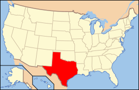
Location of Wichita County in Texas
This is intended to be a complete list of properties and districts listed on the National Register of Historic Places in Wichita County, Texas. There are two districts and seven individual properties listed on the National Register in the county. One district includes a State Antiquities Landmark and a Recorded Texas Historic Landmark. Four other individual properties are also Recorded Texas Historic Landmarks.
- This National Park Service list is complete through NPS recent listings posted June 19, 2020.[1]
Current listings
The locations of National Register properties and districts may be seen in a mapping service provided.[2]
| [3] | Name on the Register | Image | Date listed[4] | Location | City or town | Description |
|---|---|---|---|---|---|---|
| 1 | Beaver Creek Bridge | 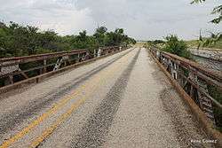 Beaver Creek Bridge |
October 10, 1996 (#96001104) |
FM 2326, 1 mi (1.6 km) W of jct. with TX 25 33°54′21″N 98°54′17″W |
Electra | |
| 2 | Depot Square Historic District |  Depot Square Historic District |
February 4, 2004 (#03001552) |
Roughly bounded by 8th St., Indiana St., 5th St. and MKT Railroad tracks 33°54′58″N 98°29′26″W |
Wichita Falls | Includes State Antiquities Landmark, Recorded Texas Historic Landmark |
| 3 | W.A. Freear Furniture Company - Maskat Shrine Temple Building | July 23, 2018 (#100002701) |
1100 Lamar St. 33°54′29″N 98°29′28″W |
Wichita Falls | ||
| 4 | William Benjamin Hamilton House |  William Benjamin Hamilton House |
October 28, 1983 (#83003826) |
1106 Brook Ave. 33°54′02″N 98°30′13″W |
Wichita Falls | |
| 5 | Hodges-Hardy-Chambers House | 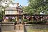 Hodges-Hardy-Chambers House |
May 2, 1985 (#85000925) |
1100 Travis St. 33°54′26″N 98°28′12″W |
Wichita Falls | Recorded Texas Historic Landmark |
| 6 | Frank Kell House | .jpg) Frank Kell House |
November 28, 1978 (#78003378) |
900 Bluff St. 33°54′27″N 98°29′49″W |
Wichita Falls | Recorded Texas Historic Landmark; 1909 Neoclassical Revival-style home of Frank Kell, one of Wichita Falls' founding fathers[5] |
| 7 | Morningside Historic District | 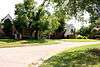 Morningside Historic District |
May 16, 1985 (#85001122) |
Roughly bounded by 9th St., Morningside Dr., Pembroke Lane and Buchanan St. 33°54′21″N 98°31′23″W |
Wichita Falls | |
| 8 | Joe and Lois Perkins House | 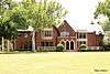 Joe and Lois Perkins House |
June 8, 2015 (#15000339) |
3301 Harrison Street 33°52′44″N 98°30′45″W |
Wichita Falls | Recorded Texas Historic Landmark |
| 9 | Weeks House | December 3, 1980 (#80004158) |
2112 Kell Boulevard 33°53′29″N 98°30′47″W |
Wichita Falls | Recorded Texas Historic Landmark | |
| 10 | Wichita Falls Route Building | 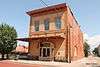 Wichita Falls Route Building |
November 29, 1978 (#78002999) |
503 8th St. 33°54′48″N 98°29′20″W |
Wichita Falls | State Antiquities Landmark; part of Depot Square Historic District |
See also
References
- "National Register of Historic Places: Weekly List Actions". National Park Service, United States Department of the Interior. Retrieved on June 19, 2020.
- The latitude and longitude information provided in this table was derived originally from the National Register Information System, which has been found to be fairly accurate for about 99% of listings. Some locations in this table may have been corrected to current GPS standards.
- Numbers represent an ordering by significant words. Various colorings, defined here, differentiate National Historic Landmarks and historic districts from other NRHP buildings, structures, sites or objects.
- The eight-digit number below each date is the number assigned to each location in the National Register Information System database, which can be viewed by clicking the number.
- Sweeten-Shults, Lana (January 22, 2011). "Historic Kell House beginning to show its age". Times Record News. Wichita Falls, Texas. Retrieved January 27, 2011.
External links
![]()
Municipalities and communities of Wichita County, Texas, United States | ||
|---|---|---|
| Cities | Wichita County map | |
| Town | ||
| Unincorporated communities | ||
This article is issued from Wikipedia. The text is licensed under Creative Commons - Attribution - Sharealike. Additional terms may apply for the media files.