National Register of Historic Places listings in Guadalupe Mountains National Park
This is a list of the National Register of Historic Places listings in Guadalupe Mountains National Park.
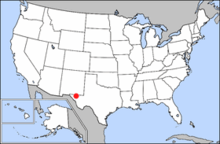
Location of Guadalupe Mountains National Park in the United States
This is intended to be a complete list of the properties and districts on the National Register of Historic Places in Guadalupe Mountains National Park, located in Culberson and Hudspeth counties in Texas. There are two districts and four individual properties listed on the National Register within the park.
- This National Park Service list is complete through NPS recent listings posted June 19, 2020.[1]
Current listings
The publicly disclosed locations of National Register properties and districts may be seen in a mapping service provided.[2]
| [3] | Name on the Register | Image | Date listed[4] | Location | City or town | Description |
|---|---|---|---|---|---|---|
| 1 | Butterfield Overland Mail Corridor |  Butterfield Overland Mail Corridor |
August 27, 2014 (#14000524) |
400 Pine Canyon Road. (Guadalupe Mountains National Park) 31°53′36″N 104°48′57″W |
Salt Flat vicinity | Includes Pinery Station |
| 2 | Guadalupe Ranch | 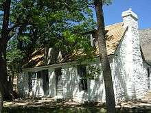 Guadalupe Ranch |
November 21, 1978 (#78000259) |
NE of Salt Flat in Guadalupe Mountains National Park 31°54′27″N 104°48′00″W |
Salt Flat | Now known as Frijole Ranch. |
| 3 | McKittrick Canyon Archeological District, Guadalupe Mountains National Park |  McKittrick Canyon Archeological District, Guadalupe Mountains National Park |
September 26, 1991 (#91001381) |
Address restricted[5] |
Salt Flat | |
| 4 | Pinery Station |  Pinery Station |
October 9, 1974 (#74000281) |
Off U.S. 62/180 31°53′38″N 104°49′01″W |
Guadalupe Mountains National Park | Contributing property of Butterfield Overland Mail Corridor historic district |
| 5 | Wallace E. Pratt House | 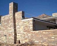 Wallace E. Pratt House |
December 15, 2011 (#11000927) |
Pratt Dr. at McKittrick Rd. 31°57′29″N 104°45′32″W |
Salt Flat vicinity | |
| 6 | Wallace Pratt Lodge | 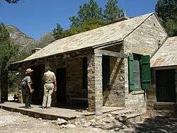 Wallace Pratt Lodge |
March 26, 1975 (#75000154) |
At jct. of N and S branch of McKittrick Canyon 31°59′01″N 104°46′50″W |
Guadalupe Mountains National Park |
See also
References
- "National Register of Historic Places: Weekly List Actions". National Park Service, United States Department of the Interior. Retrieved on June 19, 2020.
- The latitude and longitude information provided in this table was derived originally from the National Register Information System, which has been found to be fairly accurate for about 99% of listings. Some locations in this table may have been corrected to current GPS standards.
- Numbers represent an ordering by significant words. Various colorings, defined here, differentiate National Historic Landmarks and historic districts from other NRHP buildings, structures, sites or objects.
- The eight-digit number below each date is the number assigned to each location in the National Register Information System database, which can be viewed by clicking the number.
- Federal and state laws and practices restrict general public access to information regarding the specific location of this resource. In some cases, this is to protect archeological sites from vandalism, while in other cases it is restricted at the request of the owner. See: Knoerl, John; Miller, Diane; Shrimpton, Rebecca H. (1990), Guidelines for Restricting Information about Historic and Prehistoric Resources, National Register Bulletin, National Park Service, U.S. Department of the Interior, OCLC 20706997.
External links
![]()
This article is issued from Wikipedia. The text is licensed under Creative Commons - Attribution - Sharealike. Additional terms may apply for the media files.