National Register of Historic Places listings in Washington County, Texas
This is a list of the National Register of Historic Places listings in Washington County, Texas.
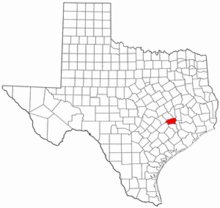
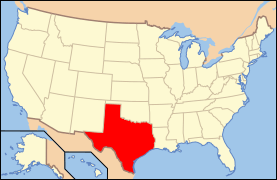
Location of Washington County in Texas
This is intended to be a complete list of properties and districts listed on the National Register of Historic Places in Washington County, Texas. There are six districts and 61 individual properties listed on the National Register in the county. Twenty-seven individually listed properties are Recorded Texas Historic Landmarks while five districts contain many more.
- This National Park Service list is complete through NPS recent listings posted June 19, 2020.[1]
Current listings
The locations of National Register properties and districts may be seen in a Google mapping service provided.[2]
| [3] | Name on the Register | Image | Date listed[4] | Location | City or town | Description |
|---|---|---|---|---|---|---|
| 1 | Allcorn-Kokemoor Farmstead | August 6, 1998 (#98001015) |
Independence Rd., 5 mi (8.0 km). north of Brenham 30°13′22″N 96°22′51″W |
Brenham | Recorded Texas Historic Landmark | |
| 2 | Isaac Applewhite House | 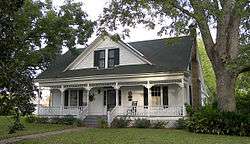 Isaac Applewhite House |
February 20, 1985 (#85000342) |
Church St. 30°08′35″N 96°15′09″W |
Chappell Hill | Recorded Texas Historic Landmark; Historic Resources of Chappell Hill MRA |
| 3 | Bassett and Bassett Banking House | .jpg) Bassett and Bassett Banking House |
April 21, 1983 (#83003168) |
222 E. Main St. 30°10′03″N 96°23′46″W |
Brenham | Recorded Texas Historic Landmark, part of Brenham Downtown Historic District |
| 4 | Becker-Hildebrandt House |  Becker-Hildebrandt House |
March 29, 1990 (#90000456) |
1402 S. Church 30°09′22″N 96°23′46″W |
Brenham | Historic and Architectural Resources of Brenham MPS |
| 5 | Blinn College | 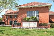 Blinn College |
March 29, 1990 (#90000446) |
Roughly bounded by Third, Jackson, Fifth, Green, College, and High 30°09′34″N 96°24′15″W |
Brenham | Includes Recorded Texas Historic Landmarks; Historic and Architectural Resources of Brenham MPS |
| 6 | Blue Bell Creameries Complex | .jpg) Blue Bell Creameries Complex |
March 29, 1990 (#90000468) |
602 Creamery 30°09′59″N 96°23′24″W |
Brenham | Historic and Architectural Resources of Brenham MPS |
| 7 | Brenham Downtown Historic District |  Brenham Downtown Historic District |
March 10, 2004 (#04000154) |
Roughly bounded W. Vulcan, E. Vulcan, South Market, West First, Bassett, S. Austin and N. Austin 30°10′00″N 96°23′49″W |
Brenham | Includes Recorded Texas Historic Landmarks; Historic and Architectural Resources of Brenham MPS |
| 8 | Brenham High School | 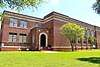 Brenham High School |
March 29, 1990 (#90000466) |
1301 S. Market 30°09′32″N 96°23′36″W |
Brenham | Historic and Architectural Resources of Brenham MPS |
| 9 | Brenham High School Gymnasium | 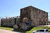 Brenham High School Gymnasium |
March 29, 1990 (#90000467) |
1301 S. Market 30°09′34″N 96°23′33″W |
Brenham | Historic and Architectural Resources of Brenham MPS |
| 10 | Brenham School | .jpg) Brenham School |
March 29, 1990 (#90000454) |
600 E. Alamo 30°10′02″N 96°23′36″W |
Brenham | Recorded Texas Historic Landmark; Historic and Architectural Resources of Brenham MPS |
| 11 | Brenham Water Works | .jpg) Brenham Water Works |
March 29, 1990 (#90000465) |
1105 S. Austin 30°09′31″N 96°23′51″W |
Brenham | Historic and Architectural Resources of Brenham MPS |
| 12 | Brockschmidt-Miller House | 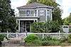 Brockschmidt-Miller House |
March 29, 1990 (#90000451) |
806 S. Day 30°09′38″N 96°24′01″W |
Brenham | Historic and Architectural Resources of Brenham MPS |
| 13 | John M. Brown House |  John M. Brown House |
April 16, 1975 (#75002010) |
South of Washington on FM 912 30°18′37″N 96°10′01″W |
Washington | |
| 14 | W. W. Browning House |  W. W. Browning House |
January 20, 1972 (#72001376) |
South of Chappell Hill near the junction of U.S. 290 and FM 1155 30°07′34″N 96°15′27″W |
Chappell Hill | Recorded Texas Historic Landmark |
| 15 | Burton Commercial Historic District | .jpg) Burton Commercial Historic District |
June 11, 1991 (#91000709) |
Roughly bounded by Railroad, Live Oak, Brazos and Burton, including area south of Railroad between Washington and Texas Sts. 30°10′54″N 96°35′45″W |
Burton | Includes Recorded Texas Historic Landmarks; Historic and Architectural Resources of Burton MPS |
| 16 | Burton Farmers Gin | .jpg) Burton Farmers Gin |
June 11, 1991 (#91000712) |
Main St. southeast of Burton St. 30°10′40″N 96°35′38″W |
Burton | Recorded Texas Historic Landmark; Historic and Architectural Resources of Burton MPS |
| 17 | Burton High School | 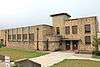 Burton High School |
June 11, 1991 (#91000711) |
Junction of Main St. and FM 390 30°11′02″N 96°35′53″W |
Burton | Recorded Texas Historic Landmark; Historic and Architectural Resources of Burton MPS |
| 18 | Chappell Hill Circulating Library | .jpg) Chappell Hill Circulating Library |
February 20, 1985 (#85000343) |
Cedar St. 30°08′32″N 96°15′19″W |
Chappell Hill | Historic Resources of Chappell Hill MRA |
| 19 | Chappell Hill Methodist Episcopal Church | 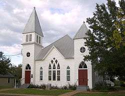 Chappell Hill Methodist Episcopal Church |
February 20, 1985 (#85000344) |
Church St. 30°08′29″N 96°15′09″W |
Chappell Hill | Recorded Texas Historic Landmark; Historic Resources of Chappell Hill MRA |
| 20 | Chappell Hill Public School and Chappell Hill Female College Bell | 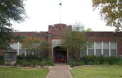 Chappell Hill Public School and Chappell Hill Female College Bell |
February 20, 1985 (#85000345) |
Poplar St. 30°08′27″N 96°15′10″W |
Chappell Hill | Historic Resources of Chappell Hill MRA |
| 21 | East Brenham |  East Brenham |
March 29, 1990 (#90000445) |
Roughly bounded by Crockett, Embrey, E. Academy, Ross, E. Main, Market, Sycamore, Cottonwood, Botts, McIntyre, and Alma 30°10′15″N 96°23′37″W |
Brenham | Includes Recorded Texas Historic Landmarks; Historic and Architectural Resources of Brenham MPS |
| 22 | E. King Felder House | 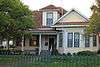 E. King Felder House |
February 20, 1985 (#85000346) |
Haller st. 30°08′28″N 96°15′50″W |
Chappell Hill | Historic Resources of Chappell Hill MRA |
| 23 | Gantt-Jones House | 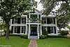 Gantt-Jones House |
November 16, 1979 (#79003022) |
1.5 mi (2.4 km). northwest of Burton off SR 1697 30°12′19″N 96°37′04″W |
Burton | Recorded Texas Historic Landmark |
| 24 | Giddings-Stone Mansion | 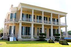 Giddings-Stone Mansion |
June 24, 1976 (#76002080) |
204 E. Stone St. 30°08′57″N 96°23′31″W |
Brenham | Recorded Texas Historic Landmark |
| 25 | Giddings-Wilkin House |  Giddings-Wilkin House |
December 12, 1976 (#76002081) |
805 Crocket St. 30°10′25″N 96°23′29″W |
Brenham | Recorded Texas Historic Landmark |
| 26 | Hatfield Plantation | January 25, 1971 (#71000971) |
Northwest of Brenham off FM 912 30°18′28″N 96°10′34″W |
Brenham | Recorded Texas Historic Landmark | |
| 27 | Hodde Drugstore | .jpg) Hodde Drugstore |
June 11, 1991 (#91000713) |
Main St. southeast of Burton St. 30°10′50″N 96°35′36″W |
Burton | Historic and Architectural Resources of Burton MPS |
| 28 | Edmund Holle House | .jpg) Edmund Holle House |
March 29, 1990 (#90000458) |
1002 S. Day 30°09′32″N 96°24′00″W |
Brenham | Historic and Architectural Resources of Brenham MPS |
| 29 | Mrs. Sam Houston House | 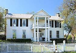 Mrs. Sam Houston House |
October 22, 1970 (#70000775) |
FM 390, 1 block east of the junction with FM 50 30°19′08″N 96°20′41″W |
Independence | Recorded Texas Historic Landmark |
| 30 | Asa Hoxey House | 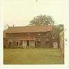 Asa Hoxey House |
June 29, 1976 (#76002083) |
West of Independence 30°19′12″N 96°21′59″W |
Independence | |
| 31 | Kneip-Bredthauer House |  Kneip-Bredthauer House |
June 11, 1991 (#91000719) |
SE corner of Colorado and Cedar 30°11′06″N 96°35′46″W |
Burton | Historic and Architectural Resources of Burton MPS |
| 32 | Dr. Charles Laas House | .jpg) Dr. Charles Laas House |
June 11, 1991 (#91000717) |
NE corner of Live Oak and Colorado Sts. 30°11′04″N 96°35′44″W |
Burton | Historic and Architectural Resources of Burton MPS |
| 33 | Dr. Robert Lenert House |  Dr. Robert Lenert House |
March 29, 1990 (#90000457) |
602 S. Market 30°09′48″N 96°23′43″W |
Brenham | Historic and Architectural Resources of Brenham MPS |
| 34 | Main Building, Blinn College | 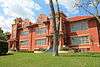 Main Building, Blinn College |
December 6, 1978 (#78002998) |
804 College Ave. 30°09′34″N 96°24′18″W |
Brenham | Recorded Texas Historic Landmark, part of Blinn College historic district |
| 35 | Main Street Historic District | .jpg) Main Street Historic District |
May 15, 1985 (#85001175) |
Main St. 30°08′35″N 96°15′25″W |
Chappell Hill | Includes Recorded Texas Historic Landmarks; Historic Resources of Chappell Hill MRA |
| 36 | Edgar Matchett House | 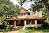 Edgar Matchett House |
March 29, 1990 (#90000462) |
502 W. Main 30°09′59″N 96°24′13″W |
Brenham | Historic and Architectural Resources of Brenham MPS |
| 37 | Mt. Zion Methodist Church | .jpg) Mt. Zion Methodist Church |
March 29, 1990 (#90000450) |
500 High 30°09′43″N 96°24′25″W |
Brenham | Historic and Architectural Resources of Brenham MPS |
| 38 | William Neumann House | 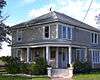 William Neumann House |
June 18, 1991 (#91000710) |
Navasota St. west of Washington St. 30°10′40″N 96°36′11″W |
Burton | Historic and Architectural Resources of Burton MPS |
| 39 | Herbert Nienstedt House | .jpg) Herbert Nienstedt House |
June 11, 1991 (#91000718) |
NE corner of Brazos and Washington Sts. 30°10′59″N 96°35′43″W |
Burton | Historic and Architectural Resources of Burton MPS |
| 40 | William Nienstedt House | .jpg) William Nienstedt House |
June 11, 1991 (#91000715) |
SE corner of Brazos and Texas Sts. 30°10′56″N 96°35′39″W |
Burton | Historic and Architectural Resources of Burton MPS |
| 41 | Pampell-Day House | 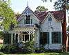 Pampell-Day House |
October 15, 1970 (#70000774) |
409 W. Alamo St. 30°09′56″N 96°24′10″W |
Brenham | Recorded Texas Historic Landmark |
| 42 | Red House | January 25, 1971 (#71000972) |
Northeast of Gay Hill via TX 36 and FM 390 30°16′55″N 96°27′27″W |
Gay Hill | Recorded Texas Historic Landmark | |
| 43 | Reichardt-Low House |  Reichardt-Low House |
March 29, 1990 (#90000455) |
609 S. Austin 30°09′45″N 96°23′54″W |
Brenham | Historic and Architectural Resources of Brenham MPS |
| 44 | Reue-Eickenhorst House | 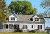 Reue-Eickenhorst House |
April 27, 1995 (#95000519) |
FM Hwy. 2621, 0.5 mi (0.80 km). east of junction with TX 50 30°15′03″N 96°21′20″W |
Brenham | Recorded Texas Historic Landmark |
| 45 | William S. Rogers House | 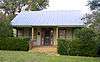 William S. Rogers House |
February 20, 1985 (#85000347) |
Cedar St. 30°08′32″N 96°15′21″W |
Chappell Hill | Historic Resources of Chappell Hill MRA |
| 46 | J. R. Routt House |  J. R. Routt House |
February 20, 1985 (#85000348) |
Chestnut St. 30°08′36″N 96°15′10″W |
Chappell Hill | Historic Resources of Chappell Hill MRA |
| 47 | William Edward Sanders House | .jpg) William Edward Sanders House |
June 11, 1991 (#91000716) |
Railroad St. southeast of US 290 30°10′35″N 96°35′28″W |
Burton | Historic and Architectural Resources of Burton MPS |
| 48 | Santa Fe Railway Company Freight Depot | .jpg) Santa Fe Railway Company Freight Depot |
March 29, 1990 (#90000459) |
214 S. Austin 30°09′55″N 96°24′00″W |
Brenham | Part of Brenham Downtown Historic District; Historic and Architectural Resources of Brenham MPS |
| 49 | Almot Schlenker House | 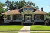 Almot Schlenker House |
March 29, 1990 (#90000461) |
405 College 30°09′36″N 96°24′03″W |
Brenham | Historic and Architectural Resources of Brenham MPS |
| 50 | Schlenker-Kolwes House |  Schlenker-Kolwes House |
March 29, 1990 (#90000460) |
1304 S. Market 30°09′26″N 96°23′37″W |
Brenham | Historic and Architectural Resources of Brenham MPS |
| 51 | Schmidt House | 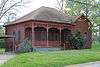 Schmidt House |
December 10, 1990 (#90001806) |
906 W. 5th St. 30°09′28″N 96°24′23″W |
Brenham | Historic and Architectural Resources of Brenham MPS |
| 52 | Fritz Paul and Emma Schroeder House | Fritz Paul and Emma Schroeder House |
September 30, 1994 (#94001169) |
Co. Rd. 68, north side, north of Brenham 30°16′51″N 96°18′29″W |
Brenham | Recorded Texas Historic Landmark |
| 53 | F. W. Schuerenberg House | 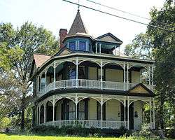 F. W. Schuerenberg House |
March 29, 1990 (#90000469) |
503 W. Alamo 30°09′55″N 96°24′12″W |
Brenham | Recorded Texas Historic Landmark; Historic and Architectural Resources of Brenham MPS |
| 54 | R. A. Schuerenberg House | .jpg) R. A. Schuerenberg House |
March 29, 1990 (#90000463) |
703 S. Market 30°09′44″N 96°23′40″W |
Brenham | Historic and Architectural Resources of Brenham MPS |
| 55 | W. E. Seelhorst House |  W. E. Seelhorst House |
March 29, 1990 (#90000470) |
702 Seelhorst 30°09′56″N 96°23′28″W |
Brenham | Recorded Texas Historic Landmark; Historic and Architectural Resources of Brenham MPS |
| 56 | Seward Plantation | 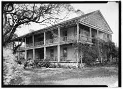 Seward Plantation |
January 29, 2013 (#12001250) |
10005 Farm to Market Road 390 E 30°19′46″N 96°19′56″W |
Independence | |
| 57 | John Sterling Smith Jr. House | 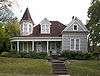 John Sterling Smith Jr. House |
February 20, 1985 (#85000349) |
Chestnut St. 30°08′35″N 96°15′12″W |
Chappell Hill | Recorded Texas Historic Landmark; Historic Resources of Chappell Hill MRA |
| 58 | Southern Pacific Railroad Freight Depot | .jpg) Southern Pacific Railroad Freight Depot |
March 29, 1990 (#90000453) |
306 S. Market 30°09′57″N 96°23′46″W |
Brenham | Recorded Texas Historic Landmark, part of Brenham Downtown Historic District; Historic and Architectural Resources of Brenham MPS |
| 59 | St. Mary's Catholic Church |  St. Mary's Catholic Church |
March 29, 1990 (#90000452) |
701 Church 30°09′42″N 96°23′49″W |
Brenham | Historic and Architectural Resources of Brenham MPS |
| 60 | Stage Coach Inn |  Stage Coach Inn |
December 12, 1976 (#76002082) |
4950 Main St. 30°08′36″N 96°15′26″W |
Chappell Hill | Part of Main Street Historic District; exceptional-quality 14-room, 1850 inn is also the oldest building in Chappell Hill. Known as Hargrove House when it served as a boarding house for college students, during the antebellum period it was an important stagecoach and telegraph office on the routes between Houston & Austin and Houston & Waco.[5] Restored in the 1970s and operated as a bed and breakfast for many years. |
| 61 | Synagogue B'nai Abraham | 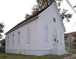 Synagogue B'nai Abraham |
March 29, 1990 (#90000464) |
302 N. Park 30°10′05″N 96°23′53″W |
Brenham | Recorded Texas Historic Landmark; Historic and Architectural Resources of Brenham MPS |
| 62 | US Post Office-Federal Building-Brenham | .jpg) US Post Office-Federal Building-Brenham |
March 29, 1990 (#90000449) |
105 S. Market 30°09′43″N 96°24′25″W |
Brenham | Part of Brenham Downtown Historic District; Historic and Architectural Resources of Brenham MPS |
| 63 | James Walker Log House | August 21, 1989 (#89001143) |
Co. Rd. 80 30°10′24″N 96°20′03″W |
Brenham | Recorded Texas Historic Landmark | |
| 64 | Washington County Courthouse | .jpg) Washington County Courthouse |
March 29, 1990 (#90000447) |
110 E. Main 30°10′01″N 96°23′51″W |
Brenham | Recorded Texas Historic Landmark, part of Brenham Downtown Historic District; Historic and Architectural Resources of Brenham MPS |
| 65 | Waverly | .jpg) Waverly |
April 14, 1983 (#83003169) |
FR 2447 30°08′42″N 96°15′03″W |
Chappell Hill | Recorded Texas Historic Landmark |
| 66 | Wehring Shoe Shop and Residence | 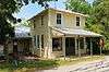 Wehring Shoe Shop and Residence |
June 11, 1991 (#91000714) |
Main St. southeast of Burton St. 30°10′47″N 96°35′36″W |
Burton | Historic and Architectural Resources of Burton MPS |
| 67 | Wood-Hughes House | .jpg) Wood-Hughes House |
March 29, 1990 (#90000448) |
614 S. Austin 30°09′43″N 96°23′56″W |
Brenham | Recorded Texas Historic Landmark; Historic and Architectural Resources of Brenham MPS |
See also
References
- "National Register of Historic Places: Weekly List Actions". National Park Service, United States Department of the Interior. Retrieved on June 19, 2020.
- The latitude and longitude information provided in this table was derived originally from the National Register Information System, which has been found to be fairly accurate for about 99% of listings. Some locations in this table may have been corrected to current GPS standards.
- Numbers represent an ordering by significant words. Various colorings, defined here, differentiate National Historic Landmarks and historic districts from other NRHP buildings, structures, sites or objects.
- The eight-digit number below each date is the number assigned to each location in the National Register Information System database, which can be viewed by clicking the number.
- Stagecoach Inn listed on aResTravel.com, retrieved 03 December 2015.
External links
![]()
Places adjacent to National Register of Historic Places listings in Washington County, Texas | ||||||||||
|---|---|---|---|---|---|---|---|---|---|---|
| ||||||||||
Municipalities and communities of Washington County, Texas, United States | ||
|---|---|---|
| cities |
|  Washington County map |
| Unincorporated communities | ||
| Ghost towns |
| |
| Footnotes | ‡This populated place also has portions in an adjacent county or counties | |
This article is issued from Wikipedia. The text is licensed under Creative Commons - Attribution - Sharealike. Additional terms may apply for the media files.