National Register of Historic Places listings in Bell County, Texas
This is a list of the National Register of Historic Places listings in Bell County, Texas.

This is intended to be a complete list of properties and districts listed on the National Register of Historic Places in Bell County, Texas. There are four districts, 66 individual properties, and one former property listed on the National Register in the county. The individually listed properties include 23 that are designated or contain Recorded Texas Historic Landmarks including one that is also a State Antiquities Landmark. Two districts contain several more Recorded Texas Historic Landmarks.
- This National Park Service list is complete through NPS recent listings posted June 19, 2020.[1]
Current listings
The locations of National Register properties and districts may be seen in a mapping service provided.[2]
| [3] | Name on the Register[4] | Image | Date listed[5] | Location | City or town | Description |
|---|---|---|---|---|---|---|
| 1 | Anderson House and Store | 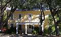 Anderson House and Store |
April 5, 1983 (#83003076) |
Main St. 30°56′46″N 97°32′12″W |
Salado | Recorded Texas Historic Landmark; Historic Resources of Salado MRA |
| 2 | Armstrong-Adams House |  Armstrong-Adams House |
April 5, 1983 (#83003077) |
Main St. and Thomas Arnold Rd. 30°56′49″N 97°32′14″W |
Salado | Recorded Texas Historic Landmark; Historic Resources of Salado MRA |
| 3 | F. K. and Mary Austin House | 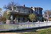 F. K. and Mary Austin House |
December 26, 1990 (#90001891) |
702 N. Penelope St. 31°03′44″N 97°27′35″W |
Belton | Historic and Architectural Resources of Belton MPS |
| 4 | Ele Baggett House | 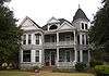 Ele Baggett House |
December 26, 1990 (#90001882) |
1019 N. Main St. 31°03′57″N 97°27′36″W |
Belton | Recorded Texas Historic Landmark; Historic and Architectural Resources of Belton MPS |
| 5 | Silas and Ellen Baggett House |  Silas and Ellen Baggett House |
December 26, 1990 (#90001881) |
1018 N. Main St. 31°03′58″N 97°27′38″W |
Belton | Historic and Architectural Resources of Belton MPS |
| 6 | George Washington Baines House | 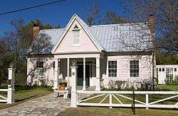 George Washington Baines House |
April 5, 1983 (#83003078) |
Royal St. 30°56′31″N 97°31′59″W |
Salado | Recorded Texas Historic Landmark; Historic Resources of Salado MRA |
| 7 | Barbee-Berry Mercantile Building | 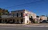 Barbee-Berry Mercantile Building |
August 22, 1984 (#84001571) |
Main and Royal St. 30°56′35″N 97°32′13″W |
Salado | Historic Resources of Salado MRA |
| 8 | Barclay-Bryan House |  Barclay-Bryan House |
May 10, 1984 (#84001572) |
804 S. 25th St. 31°05′32″N 97°21′28″W |
Temple | |
| 9 | Bartlett Commercial Historic District | 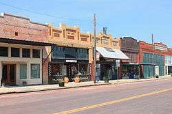 Bartlett Commercial Historic District |
September 30, 1980 (#80004076) |
E. Clark St. 30°47′42″N 97°25′37″W |
Bartlett | Extends into Williamson County |
| 10 | Barton House | 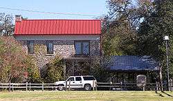 Barton House |
April 5, 1983 (#83003079) |
Main St. 30°56′51″N 97°32′07″W |
Salado | Historic Resources of Salado MRA |
| 11 | Baylor Female College Historic District | 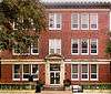 Baylor Female College Historic District |
December 26, 1990 (#90001869) |
Bounded by King, College and W. Ninth Sts. 31°04′01″N 97°27′50″W |
Belton | Includes Recorded Texas Historic Landmark; Historic and Architectural Resources of Belton MPS |
| 12 | William Beamer House |  William Beamer House |
December 26, 1990 (#90001875) |
1202 S. Beal St. 31°02′41″N 97°27′52″W |
Belton | Historic and Architectural Resources of Belton MPS |
| 13 | Bell County Courthouse | .jpg) Bell County Courthouse |
December 12, 1976 (#76002004) |
Public Sq. 31°03′21″N 97°27′49″W |
Belton | State Antiquities Landmark, Recorded Texas Historic Landmark; part of Belton Commercial Historic District |
| 14 | Belton Academy | .jpg) Belton Academy |
December 26, 1990 (#90001937) |
404 E. Ninth St. 31°03′49″N 97°27′28″W |
Belton | Recorded Texas Historic Landmark; Historic and Architectural Resources of Belton MPS; also called Charles Wedemeyer House |
| 15 | Belton Commercial Historic District | .jpg) Belton Commercial Historic District |
December 26, 1990 (#90001868) |
Roughly bounded by Nolan Valley Rd., Penelope St. and Nolan Cr.. 31°03′23″N 97°27′45″W |
Belton | Includes State Antiquities Landmark, Recorded Texas Historic Landmarks; Historic and Architectural Resources of Belton MPS |
| 16 | Belton Farmers' Gin Coop | Belton Farmers' Gin Coop |
December 26, 1990 (#90001870) |
219 S. East Ave., Building 4 31°03′18″N 97°27′45″W |
Belton | Recorded Texas Historic Landmark; Historic and Architectural Resources of Belton MPS |
| 17 | Belton Standpipe | 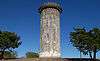 Belton Standpipe |
December 26, 1990 (#90001900) |
NW of jct. of TX 317 & I-35 31°02′58″N 97°28′12″W |
Belton | Historic and Architectural Resources of Belton MPS |
| 18 | Belton Yarn Mill | 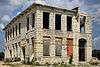 Belton Yarn Mill |
December 26, 1990 (#90001899) |
805 E. Fourth St. 31°03′28″N 97°27′14″W |
Belton | Historic and Architectural Resources of Belton MPS |
| 19 | T. Hamp and Beulah Birdwell House | December 26, 1990 (#90001896) |
503 N. Wall 31°03′37″N 97°27′32″W |
Belton | Historic and Architectural Resources of Belton MPS | |
| 20 | R. F. and Lena Burford House | 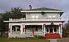 R. F. and Lena Burford House |
December 26, 1990 (#90001893) |
920 N. Penelope St. 31°03′01″N 97°27′33″W |
Belton | Historic and Architectural Resources of Belton MPS |
| 21 | Carnegie Public Library | 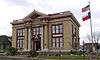 Carnegie Public Library |
March 4, 1985 (#85000473) |
201 N. Main St. 31°03′27″N 97°27′48″W |
Belton | Recorded Texas Historic Landmark; part of Belton Commercial Historic District |
| 22 | Cornelison House | 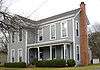 Cornelison House |
December 26, 1990 (#90001886) |
1102 N. Pearl St. 31°04′01″N 97°27′41″W |
Belton | Historic and Architectural Resources of Belton MPS |
| 23 | Davis House | 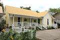 Davis House |
April 5, 1983 (#83003080) |
Main St. 30°56′41″N 97°32′11″W |
Salado | Historic Resources of Salado MRA |
| 24 | Joel Elliott House | December 26, 1990 (#90001876) |
716 N. College St. 31°03′50″N 97°27′51″W |
Belton | Historic and Architectural Resources of Belton MPS | |
| 25 | Ferguson House | 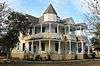 Ferguson House |
December 8, 1978 (#78002888) |
518 N. 7th St. 31°06′12″N 97°20′36″W |
Temple | Recorded Texas Historic Landmark |
| 26 | James A. Ferguson House |  James A. Ferguson House |
December 26, 1990 (#90001874) |
1123 N. Beal St. 31°03′57″N 97°27′19″W |
Belton | Historic and Architectural Resources of Belton MPS |
| 27 | James E. and Miriam Ferguson House |  James E. and Miriam Ferguson House |
December 26, 1990 (#90001889) |
604 N. Penelope St. 31°03′41″N 97°27′37″W |
Belton | Historic and Architectural Resources of Belton MPS |
| 28 | First Christian Church Parsonage |  First Christian Church Parsonage |
December 26, 1990 (#90001890) |
608 N. Penelope St. 31°03′43″N 97°27′36″W |
Belton | Historic and Architectural Resources of Belton MPS |
| 29 | Fowler House | 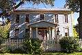 Fowler House |
April 5, 1983 (#83003081) |
Main St. 30°57′30″N 97°31′58″W |
Salado | Recorded Texas Historic Landmark; Historic Resources of Salado MRA |
| 30 | Dr. Jacob Moore Frazier House | December 26, 1990 (#90001897) |
618 N. Wall 31°03′42″N 97°27′32″W |
Belton | Historic and Architectural Resources of Belton MPS | |
| 31 | Gault Archaeological Site | 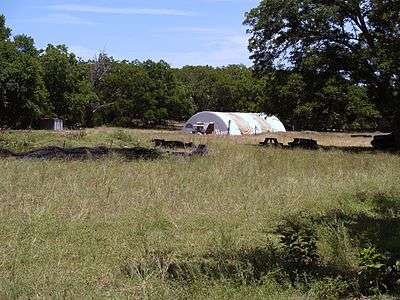 Gault Archaeological Site |
May 29, 2018 (#100002469) |
Address Restricted |
Florence | |
| 32 | Gray Rental Houses |  Gray Rental Houses |
December 26, 1990 (#90001934) |
702-708 N. Pearl St. 31°03′48″N 97°27′46″W |
Belton | Historic and Architectural Resources of Belton MPS |
| 33 | Capt. Robert Halley House | 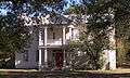 Capt. Robert Halley House |
April 5, 1983 (#83003082) |
Main St. 30°57′15″N 97°31′57″W |
Salado | Recorded Texas Historic Landmark; Historic Resources of Salado MRA |
| 34 | John P. Hammersmith House | 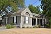 John P. Hammersmith House |
December 26, 1990 (#90001883) |
520 S. Main St. 31°03′10″N 97°27′56″W |
Belton | Recorded Texas Historic Landmark; Historic and Architectural Resources of Belton MPS; also called Clark House |
| 35 | Capt. Andrew Jackson Harris House |  Capt. Andrew Jackson Harris House |
December 26, 1990 (#90001871) |
1001 W. Tenth Ave. 31°04′02″N 97°28′09″W |
Belton | Recorded Texas Historic Landmark; Historic and Architectural Resources of Belton MPS |
| 36 | Hendrickson-Caskey House | 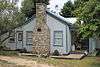 Hendrickson-Caskey House |
February 10, 1995 (#95000054) |
Center Circle 30°56′42″N 97°31′54″W |
Salado | Historic Resources of Salado MRA |
| 37 | House at 402 N. East St. | December 26, 1990 (#90001878) |
402 N. East St. 31°03′33″N 97°27′44″W |
Belton | Historic and Architectural Resources of Belton MPS | |
| 38 | House at 730 N. Beal St. | December 26, 1990 (#90001936) |
730 N. Beal St. 31°03′45″N 97°27′26″W |
Belton | Historic and Architectural Resources of Belton MPS | |
| 39 | Dr. Taylor Hudson House | 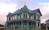 Dr. Taylor Hudson House |
December 26, 1990 (#90001879) |
324 N. Main St. 31°03′33″N 97°27′48″W |
Belton | Historic and Architectural Resources of Belton MPS |
| 40 | James House | December 26, 1990 (#90001873) |
805 N. Beal St. 31°03′48″N 97°27′22″W |
Belton | Historic and Architectural Resources of Belton MPS | |
| 41 | Killeen Downtown Historic District | 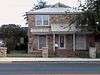 Killeen Downtown Historic District |
March 31, 2014 (#14000098) |
Roughly bounded by Avenue A, Santa Fe Plaza, North 4th & North 8th Streets 31°07′19″N 97°43′38″W |
Killeen | |
| 42 | Killeen High School | 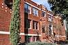 Killeen High School |
May 18, 2015 (#15000244) |
101 North College Street 31°07′16″N 97°44′00″W |
Killeen | Recorded Texas Historic Landmark |
| 43 | L. B. Kinchion House | 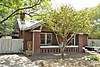 L. B. Kinchion House |
December 26, 1990 (#90001887) |
702 S. Pearl St. 31°03′04″N 97°27′58″W |
Belton | Historic and Architectural Resources of Belton MPS |
| 44 | Kyle Hotel | 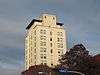 Kyle Hotel |
August 5, 1993 (#93000772) |
111 Main St. 31°05′54″N 97°20′26″W |
Temple | Part of Temple Commercial Historic District |
| 45 | Walter J. Lee House | December 26, 1990 (#90001877) |
804 N. College St. 31°03′52″N 97°27′49″W |
Belton | Historic and Architectural Resources of Belton MPS | |
| 46 | George and Martha McWhirter House | 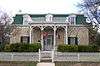 George and Martha McWhirter House |
December 26, 1990 (#90001884) |
400 N. Pearl St. 31°03′36″N 97°27′50″W |
Belton | Historic and Architectural Resources of Belton MPS |
| 47 | V. R. Means House | 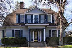 V. R. Means House |
December 26, 1990 (#90001938) |
609 E. 14th St. 31°04′04″N 97°27′05″W |
Belton | Historic and Architectural Resources of Belton MPS |
| 48 | J. Z. Miller House | December 26, 1990 (#90001892) |
804 N. Penelope St. 31°03′47″N 97°27′33″W |
Belton | Historic and Architectural Resources of Belton MPS | |
| 49 | Miller-Curtis House |  Miller-Curtis House |
April 7, 1983 (#83003083) |
1004 N. Main St. 31°03′56″N 97°27′38″W |
Belton | Recorded Texas Historic Landmark; also called Curtis Mansion |
| 50 | Missouri, Kansas & Texas Railroad Bridge at the Leon River | December 26, 1990 (#90001898) |
Across the Leon R. at Taylor's Valley Rd. 31°03′44″N 97°26′35″W |
Belton | Historic and Architectural Resources of Belton MPS | |
| 51 | Morey House | 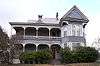 Morey House |
December 26, 1990 (#90001880) |
328 N. Main St. 31°03′33″N 97°27′47″W |
Belton | Historic and Architectural Resources of Belton MPS |
| 52 | Mount Zion United Methodist Church |  Mount Zion United Methodist Church |
December 26, 1990 (#90001872) |
218 Alexander St. 31°03′35″N 97°27′57″W |
Belton | Historic and Architectural Resources of Belton MPS |
| 53 | Robert Naismith House | December 26, 1990 (#90001888) |
440 N. Penelope St. 31°03′36″N 97°27′39″W |
Belton | Historic and Architectural Resources of Belton MPS | |
| 54 | Norton-Orgain House | 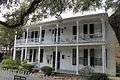 Norton-Orgain House |
March 25, 1992 (#92000185) |
Main St. 30°56′50″N 97°32′11″W |
Salado | Recorded Texas Historic Landmark; Historic Resources of Salado MRA |
| 55 | Old St. Luke's Episcopal Church |  Old St. Luke's Episcopal Church |
January 17, 1974 (#74002056) |
438 N. Wall St. 31°03′36″N 97°27′33″W |
Belton | |
| 56 | Arthur Potts House | December 26, 1990 (#90001895) |
445 N. Wall 31°03′35″N 97°27′33″W |
Belton | Historic and Architectural Resources of Belton MPS | |
| 57 | Col. Elijah Sterling Clack Robertson Plantation | 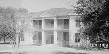 Col. Elijah Sterling Clack Robertson Plantation |
April 5, 1983 (#83003084) |
I-35 30°56′32″N 97°32′34″W |
Salado | Recorded Texas Historic Landmark; Historic Resources of Salado MRA |
| 58 | Maj. A. J. Rose House | 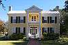 Maj. A. J. Rose House |
May 22, 1978 (#78002887) |
Wm. Rose Way and Royal St. 30°56′26″N 97°31′46″W |
Salado | Recorded Texas Historic Landmark |
| 59 | Salado College Archeological Site |  Salado College Archeological Site |
March 1, 1985 (#85000403) |
Main St & College Hill 30°56′30″N 97°32′14″W |
Salado | Historic Resources of Salado MRA; Smithsonian trinomial 41BL241 |
| 60 | Salado United Methodist Church | 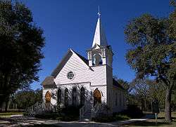 Salado United Methodist Church |
August 22, 1984 (#84001573) |
Off Royal St. 30°56′30″N 97°31′44″W |
Salado | Recorded Texas Historic Landmark; Historic Resources of Salado MRA; built in 1890; moved from its original location in 2005. |
| 61 | Stagecoach Inn |  Stagecoach Inn |
April 5, 1983 (#83003085) October 10, 2017 boundary increase (#100001721) |
Main and Front Sts.; also 401 S. Stagecoach Rd. 30°56′31″N 97°32′15″W |
Salado | Recorded Texas Historic Landmark; Historic Resources of Salado MRA; second set of addresses represent a boundary increase approved October 10, 2017. |
| 62 | State Highway 53 Bridge at the Leon River |  State Highway 53 Bridge at the Leon River |
October 10, 1996 (#96001119) |
FM 817, 2.5 mi (4.0 km). E of jct. with FM 93 31°03′59″N 97°26′33″W |
Belton | Historic Bridges of Texas, 1866-1945 MPS |
| 63 | Temple Commercial Historic District | 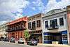 Temple Commercial Historic District |
October 28, 2005 (#05001192) |
Roughly bounded by French Av., 3rd St., Av. D & 6th St. 31°05′53″N 97°20′28″W |
Temple | Includes Recorded Texas Historic Landmarks |
| 64 | Levi Tenney House |  Levi Tenney House |
April 5, 1983 (#83003086) |
Pace Park Dr. 30°56′49″N 97°32′08″W |
Salado | Historic Resources of Salado MRA |
| 65 | Twelve Oaks | .jpg) Twelve Oaks |
April 5, 1983 (#83003088) |
Center Cirlce 30°56′45″N 97°31′55″W |
Salado | Recorded Texas Historic Landmark; Historic Resources of Salado MRA |
| 66 | Tyler House |  Tyler House |
April 5, 1983 (#83003087) |
Main St. 30°56′45″N 97°32′15″W |
Salado | Historic Resources of Salado MRA |
| 67 | W. J. Venable House | December 26, 1990 (#90001894) |
426 N. Wall 31°03′32″N 97°27′34″W |
Belton | Historic and Architectural Resources of Belton MPS | |
| 68 | Vickrey House | 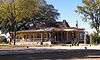 Vickrey House |
April 5, 1983 (#83003089) |
Main St. 30°57′04″N 97°32′11″W |
Salado | Recorded Texas Historic Landmark; Historic Resources of Salado MRA |
| 69 | H. A. and Helena Ware House | .jpg) H. A. and Helena Ware House |
December 26, 1990 (#90001885) |
401 N. Pearl St. 31°03′35″N 97°27′48″W |
Belton | Historic and Architectural Resources of Belton MPS |
| 70 | White-Aiken House |  White-Aiken House |
April 5, 1983 (#83003090) |
I-35 30°57′36″N 97°31′58″W |
Salado | Historic Resources of Salado MRA |
| 71 | Ralph and Sunny Wilson Sr. House |  Ralph and Sunny Wilson Sr. House |
November 25, 1998 (#98001374) |
1714 S. 61st. St. 31°05′17″N 97°22′50″W |
Temple |
Former listing
| [3] | Name on the Register | Image | Date listed | Date removed | Location | City or town | Summary |
|---|---|---|---|---|---|---|---|
| 1 | Dr. R. S. Farr House | December 26, 1990 (#90001935) | August 30, 1994 | 801 E Central Ave. |
Belton |
See also
- National Register of Historic Places listings in Texas
- Recorded Texas Historic Landmarks in Bell County
References
- "National Register of Historic Places: Weekly List Actions". National Park Service, United States Department of the Interior. Retrieved on June 19, 2020.
- The latitude and longitude information provided in this table was derived originally from the National Register Information System, which has been found to be fairly accurate for about 99% of listings. Some locations in this table may have been corrected to current GPS standards.
- Numbers represent an ordering by significant words. Various colorings, defined here, differentiate National Historic Landmarks and historic districts from other NRHP buildings, structures, sites or objects.
- "National Register Information System". National Register of Historic Places. National Park Service. July 9, 2010.
- The eight-digit number below each date is the number assigned to each location in the National Register Information System database, which can be viewed by clicking the number.
External links
![]()
Places adjacent to National Register of Historic Places listings in Bell County, Texas | ||||||||||
|---|---|---|---|---|---|---|---|---|---|---|
| ||||||||||
Municipalities and communities of Bell County, Texas, United States | ||
|---|---|---|
| Cities |  Bell County map | |
| Towns | ||
| Village | ||
| CDP | ||
| Other unincorporated communities |
| |
| Ghost towns |
| |
| Footnotes | ‡This populated place also has portions in an adjacent county or counties | |