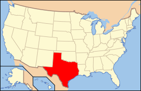
National Register of Historic Places listings in Tom Green County, Texas
This is a list of the National Register of Historic Places listings in Tom Green County, Texas.
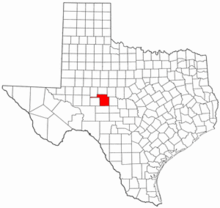
This is intended to be a complete list of properties and districts listed on the National Register of Historic Places in Tom Green County, Texas. The county hosts two districts, one of which is a National Historic Landmark (NHL), and 66 individually listed properties. The NHL district is also a State Antiquities Landmark and contains numerous Recorded Texas Historic Landmarks (RTHL). Six additional National Register properties are also RTHLs. An additional property has been removed from the National Register.
- This National Park Service list is complete through NPS recent listings posted June 19, 2020.[1]
Current listings
The locations of National Register properties and districts may be seen in a mapping service provided.[2]
| [3] | Name on the Register[4] | Image | Date listed[5] | Location | City or town | Description |
|---|---|---|---|---|---|---|
| 1 | Angelo Heights Historic District | 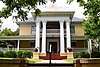 Angelo Heights Historic District |
November 25, 1988 (#88002605) |
Roughly bounded by Colorado St., the Concho River, Live Oak St., S. Bishop St., Twohig St., and S. Washington St. 31°27′18″N 100°27′21″W |
San Angelo | San Angelo Multiple Resource Area (MRA) |
| 2 | Aztec Cleaners and Laundry Building |  Aztec Cleaners and Laundry Building |
November 25, 1988 (#88002577) |
119 S. Irving 31°27′39″N 100°26′17″W |
San Angelo | San Angelo MRA |
| 3 | Frederick Beck Farm | 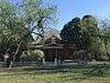 Frederick Beck Farm |
November 25, 1988 (#88002566) |
1231 Culberson 31°27′44″N 100°25′03″W |
San Angelo | Recorded Texas Historic Landmark, San Angelo MRA |
| 4 | J. B. Blakeney House | .jpg) J. B. Blakeney House |
November 25, 1988 (#88002600) |
438 W. Twohig 31°27′31″N 100°26′40″W |
San Angelo | San Angelo MRA |
| 5 | C. A. Broome House | .jpg) C. A. Broome House |
November 25, 1988 (#88002567) |
123 S. David 31°27′31″N 100°26′43″W |
San Angelo | San Angelo MRA |
| 6 | R. Wilbur Brown House | 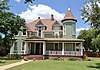 R. Wilbur Brown House |
November 25, 1988 (#88002585) |
1004 Pecos 31°27′34″N 100°27′08″W |
San Angelo | San Angelo MRA |
| 7 | Building at 113-119 East Concho | Building at 113-119 East Concho |
September 13, 1990 (#88002564) |
113-119 E. Concho 31°27′38″N 100°25′57″W |
San Angelo | San Angelo MRA |
| 8 | Clayton House | 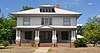 Clayton House |
November 25, 1988 (#88002570) |
1101 S. David 31°27′01″N 100°26′36″W |
San Angelo | San Angelo MRA |
| 9 | Collyns House | .jpg) Collyns House |
November 25, 1988 (#88002597) |
315 W. Twohig 31°27′32″N 100°26′32″W |
San Angelo | San Angelo MRA |
| 10 | Develin House | %2C_San_Angelo%2C_TX.jpg) Develin House |
November 25, 1988 (#88002568) |
913 S. David 31°27′07″N 100°26′36″W |
San Angelo | San Angelo MRA |
| 11 | Eckert House | 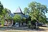 Eckert House |
November 25, 1988 (#88002578) |
503 Koberlin 31°28′04″N 100°25′42″W |
San Angelo | San Angelo MRA |
| 12 | Emmanuel Episcopal Church | %2C_San_Angelo%2C_TX.jpg) Emmanuel Episcopal Church |
November 25, 1988 (#88002590) |
3 S. Randolph 31°27′44″N 100°26′27″W |
San Angelo | Recorded Texas Historic Landmark, San Angelo MRA |
| 13 | First Presbyterian Church | 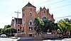 First Presbyterian Church |
November 25, 1988 (#88002604) |
32 N. Irving 31°27′52″N 100°26′21″W |
San Angelo | San Angelo MRA |
| 14 | O. C. Fisher Federal Building | .jpg) O. C. Fisher Federal Building |
November 25, 1988 (#88002592) |
33 E. Twohig 31°27′42″N 100°26′04″W |
San Angelo | San Angelo MRA |
| 15 | Fort Concho Historic District | 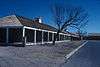 Fort Concho Historic District |
October 15, 1966 (#66000823) |
South edge of downtown San Angelo 31°27′10″N 100°25′45″W |
San Angelo | State Antiquities Landmark; includes multiple Recorded Texas Historic Landmarks |
| 16 | Freeze Building | 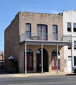 Freeze Building |
June 20, 1997 (#97000615) |
18 W. Concho Ave. 31°27′36″N 100°26′11″W |
San Angelo | |
| 17 | Greater St. Paul AME Church | 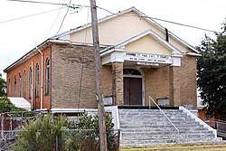 Greater St. Paul AME Church |
November 25, 1988 (#88002548) |
215 W. 3rd St. 31°27′57″N 100°26′32″W |
San Angelo | San Angelo MRA |
| 18 | Hagelstein Commercial Building | 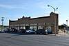 Hagelstein Commercial Building |
November 25, 1988 (#88002560) |
616-620 S. Chadbourne 31°27′17″N 100°26′04″W |
San Angelo | San Angelo MRA |
| 19 | R. A. Hall House |  R. A. Hall House |
November 25, 1988 (#88002595) |
215 W. Twohig 31°27′34″N 100°26′24″W |
San Angelo | San Angelo MRA |
| 20 | Harris Drug Store | 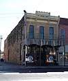 Harris Drug Store |
June 14, 2001 (#01000665) |
114 S. Chadbourne St. 31°27′43″N 100°26′11″W |
San Angelo | |
| 21 | S. L. Henderson House | S. L. Henderson House |
November 25, 1988 (#88002583) |
1303 S. Park 31°26′54″N 100°26′50″W |
San Angelo | San Angelo MRA |
| 22 | Hilton Hotel | .jpg) Hilton Hotel |
September 20, 1984 (#84001999) |
36 E. Twohig St. 31°27′43″N 100°26′05″W |
San Angelo | |
| 23 | Holcomb-Blanton Print Shop | November 25, 1988 (#88002554) |
24 W. Beauregard 31°27′44″N 100°26′17″W |
San Angelo | San Angelo MRA. Demolished. | |
| 24 | House at 1017 South David | %2C_San_Angelo%2C_TX.jpg) House at 1017 South David |
November 25, 1988 (#88002569) |
1017 S. David 31°27′04″N 100°26′36″W |
San Angelo | San Angelo MRA |
| 25 | House at 123 Allen | 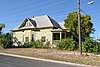 House at 123 Allen |
November 25, 1988 (#88002601) |
123 Allen 31°27′31″N 100°25′52″W |
San Angelo | San Angelo MRA |
| 26 | House at 1325 South David | %2C_San_Angelo%2C_TX.jpg) House at 1325 South David |
November 25, 1988 (#88002571) |
1325 S. David 31°26′51″N 100°26′36″W |
San Angelo | San Angelo MRA |
| 27 | House at 140 Allen | 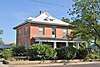 House at 140 Allen |
November 25, 1988 (#88002550) |
140 Allen 31°27′33″N 100°25′51″W |
San Angelo | San Angelo MRA |
| 28 | House at 1621 North Chadbourne |  House at 1621 North Chadbourne |
November 25, 1988 (#88002559) |
1621 N. Chadbourne 31°28′38″N 100°26′48″W |
San Angelo | San Angelo MRA |
| 29 | House at 221 North Magdalen | 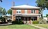 House at 221 North Magdalen |
November 25, 1988 (#88002579) |
221 N. Magdalen 31°28′04″N 100°26′06″W |
San Angelo | San Angelo MRA |
| 30 | House at 405 Preusser | 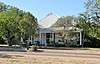 House at 405 Preusser |
November 25, 1988 (#88002586) |
405 Preusser 31°27′58″N 100°25′47″W |
San Angelo | San Angelo MRA |
| 31 | House at 419 West Avenue C | November 25, 1988 (#88002544) |
419 West Ave. C 31°27′15″N 100°26′27″W |
San Angelo | San Angelo MRA | |
| 32 | House at 421 West Twohig | 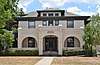 House at 421 West Twohig |
November 25, 1988 (#88002598) |
421 W. Twohig 31°27′30″N 100°26′37″W |
San Angelo | San Angelo MRA |
| 33 | House at 427 West Twohig |  House at 427 West Twohig |
September 13, 1990 (#88002599) |
427 W. Twohig 31°27′30″N 100°26′40″W |
San Angelo | San Angelo MRA |
| 34 | House at 521 West Highland Boulevard | 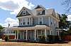 House at 521 West Highland Boulevard |
November 25, 1988 (#88002575) |
521 W. Highland Blvd. 31°27′05″N 100°26′35″W |
San Angelo | San Angelo MRA |
| 35 | House at 715 Austin | 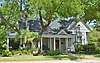 House at 715 Austin |
November 25, 1988 (#88002551) |
715 Austin 31°27′14″N 100°26′42″W |
San Angelo | San Angelo MRA |
| 36 | House at 731 Preusser | .jpg) House at 731 Preusser |
November 25, 1988 (#88002589) |
731 Preusser 31°27′58″N 100°25′27″W |
San Angelo | San Angelo MRA |
| 37 | Household Furniture Co. | 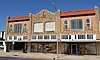 Household Furniture Co. |
November 25, 1988 (#88002558) |
11 N. Chadbourne 31°27′51″N 100°26′16″W |
San Angelo | San Angelo MRA |
| 38 | Iglesia Santa Maria | 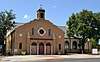 Iglesia Santa Maria |
November 25, 1988 (#88002547) |
7 West Ave. N 31°26′33″N 100°26′04″W |
San Angelo | San Angelo MRA |
| 39 | Lone Wolf Crossing Bridge | .jpg) Lone Wolf Crossing Bridge |
November 25, 1988 (#88002546) |
Ave. K extension, E of Oakes 31°26′45″N 100°25′30″W |
San Angelo | San Angelo MRA |
| 40 | Mason-Hughes House | 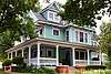 Mason-Hughes House |
November 25, 1988 (#88002557) |
1104 W. Beauregard 31°27′27″N 100°27′08″W |
San Angelo | San Angelo MRA |
| 41 | Masonic Lodge 570 | 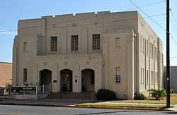 Masonic Lodge 570 |
November 25, 1988 (#88002580) |
130 S. Oakes 31°27′44″N 100°26′03″W |
San Angelo | San Angelo MRA |
| 42 | J. T. and Minnie McClelland House | 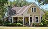 J. T. and Minnie McClelland House |
November 25, 1988 (#88002576) |
715 W. Highland 31°27′05″N 100°26′42″W |
San Angelo | San Angelo MRA |
| 43 | Monogram Square | 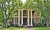 Monogram Square |
November 25, 1988 (#88002602) |
305 W. Concho 31°27′28″N 100°26′28″W |
San Angelo | San Angelo MRA |
| 44 | Montgomery Ward Building | %2C_San_Angelo%2C_TX.jpg) Montgomery Ward Building |
November 25, 1988 (#88002553) |
10 W. Beauregard 31°27′45″N 100°26′13″W |
San Angelo | San Angelo MRA |
| 45 | Municipal Swimming Pool | 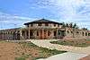 Municipal Swimming Pool |
November 25, 1988 (#88002543) |
18 East Ave. A 31°27′24″N 100°25′59″W |
San Angelo | Recorded Texas Historic Landmark, San Angelo MRA |
| 46 | Murrah House | 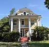 Murrah House |
November 25, 1988 (#88002594) |
212 W. Twohig 31°27′37″N 100°26′24″W |
San Angelo | San Angelo MRA |
| 47 | Oakes Hotel Building | 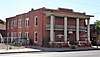 Oakes Hotel Building |
November 25, 1988 (#88002581) |
204 S. Oakes 31°27′42″N 100°26′03″W |
San Angelo | San Angelo MRA |
| 48 | Princess Ice Cream Co. | .jpg) Princess Ice Cream Co. |
November 25, 1988 (#88002556) |
217 W. Beauregard 31°27′39″N 100°26′26″W |
San Angelo | San Angelo MRA |
| 49 | J. J. Rackley Building |  J. J. Rackley Building |
June 30, 1983 (#83003163) |
118 S. Chadbourne 31°27′42″N 100°26′10″W |
San Angelo | |
| 50 | Roosevelt Hotel |  Roosevelt Hotel |
May 14, 2018 (#100002436) |
50 N Chadbourne St. 31°27′55″N 100°26′15″W |
San Angelo | |
| 51 | San Angelo City Hall | .jpg) San Angelo City Hall |
November 25, 1988 (#88002563) |
City Hall Plaza 31°27′53″N 100°26′21″W |
San Angelo | San Angelo MRA |
| 52 | San Angelo National Bank Building |  San Angelo National Bank Building |
December 16, 1982 (#82001740) |
201 S. Chadbourne St. 31°27′40″N 100°26′11″W |
San Angelo | |
| 53 | San Angelo National Bank, Johnson and Taylor, and Schwartz and Raas Buildings |  San Angelo National Bank, Johnson and Taylor, and Schwartz and Raas Buildings |
April 7, 1978 (#78002988) |
20-22, 24, 26 E. Concho Ave. 31°27′38″N 100°26′03″W |
San Angelo | Recorded Texas Historic Landmark |
| 54 | San Angelo Telephone Company Building |  San Angelo Telephone Company Building |
November 25, 1988 (#88002593) |
14 W. Twohig 31°27′41″N 100°26′11″W |
San Angelo | San Angelo MRA |
| 55 | Santa Fe Passenger Depot | .jpg) Santa Fe Passenger Depot |
November 27, 1989 (#88002561) |
700 S. Chadbourne 31°27′14″N 100°26′05″W |
San Angelo | Recorded Texas Historic Landmark, San Angelo MRA |
| 56 | Santa Fe Railway Freight Depot | .jpg) Santa Fe Railway Freight Depot |
November 27, 1989 (#88002562) |
700 S. Chadbourne 31°27′16″N 100°26′02″W |
San Angelo | Recorded Texas Historic Landmark, San Angelo MRA |
| 57 | William Schneemann House | .jpg) William Schneemann House |
November 25, 1988 (#88002588) |
724 Preusser St. 31°28′01″N 100°25′28″W |
San Angelo | San Angelo MRA |
| 58 | Shepperson House | 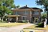 Shepperson House |
November 25, 1988 (#88002587) |
716 Preusser 31°28′01″N 100°25′33″W |
San Angelo | San Angelo MRA |
| 59 | Texas Highway Department Building, Warehouse and Motor Vehicle Division | 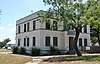 Texas Highway Department Building, Warehouse and Motor Vehicle Division |
November 25, 1988 (#88002582) |
100 Paint Rock Rd. 31°26′42″N 100°25′08″W |
San Angelo | San Angelo MRA |
| 60 | Tom Green County Courthouse | .jpg) Tom Green County Courthouse |
November 25, 1988 (#88002555) |
100 W. Beauregard 31°27′45″N 100°26′22″W |
San Angelo | San Angelo MRA |
| 61 | Tom Green County Jail | 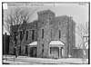 Tom Green County Jail |
October 22, 1976 (#76002246) |
US 67 31°27′47″N 100°26′22″W |
San Angelo | Demolished in 1977[6] |
| 62 | C. C. Walsh House | 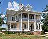 C. C. Walsh House |
September 13, 1990 (#88002584) |
922 Pecos 31°27′36″N 100°27′06″W |
San Angelo | San Angelo MRA |
| 63 | Dr. Herbert A. Wardlaw House | Dr. Herbert A. Wardlaw House |
November 25, 1988 (#88002596) |
233 W. Twohig 31°27′32″N 100°26′31″W |
San Angelo | San Angelo MRA |
| 64 | West Texas Utilities Office | 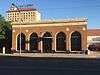 West Texas Utilities Office |
November 25, 1988 (#88002552) |
15 E. Beauregard 31°27′45″N 100°26′08″W |
San Angelo | San Angelo MRA |
| 65 | John C. Westbrook House | November 25, 1988 (#88002545) |
600 West Ave. C 31°27′17″N 100°26′17″W |
San Angelo | San Angelo MRA | |
| 66 | John and Anton Willeke House | 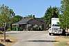 John and Anton Willeke House |
November 25, 1988 (#88002573) |
941 E. Harris 31°27′53″N 100°25′17″W |
San Angelo | San Angelo MRA |
| 67 | John Willeke Jr. House | 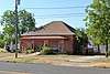 John Willeke Jr. House |
November 25, 1988 (#88002574) |
1005 E. Harris 31°27′54″N 100°25′16″W |
San Angelo | San Angelo MRA |
| 68 | John Willeke Sr. House | 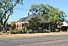 John Willeke Sr. House |
November 25, 1988 (#88002572) |
931 E. Harris 31°27′54″N 100°25′18″W |
San Angelo | San Angelo MRA |
| 69 | Dr. M. M. Woodward House |  Dr. M. M. Woodward House |
November 25, 1988 (#88002549) |
44 W. 25th St. 31°29′05″N 100°27′12″W |
San Angelo | San Angelo MRA |
Former listings
| [3] | Name on the Register | Image | Date listed | Date removed | Location | City or town | Summary |
|---|---|---|---|---|---|---|---|
| 1 | House at 410 Summit St. | November 25, 1988 (#88002591) | July 27, 1999 | 410 Summit St. |
San Angelo |
See also
References
- "National Register of Historic Places: Weekly List Actions". National Park Service, United States Department of the Interior. Retrieved on June 19, 2020.
- The latitude and longitude information provided in this table was derived originally from the National Register Information System, which has been found to be fairly accurate for about 99% of listings. Some locations in this table may have been corrected to current GPS standards.
- Numbers represent an ordering by significant words. Various colorings, defined here, differentiate National Historic Landmarks and historic districts from other NRHP buildings, structures, sites or objects.
- "National Register Information System". National Register of Historic Places. National Park Service. April 24, 2008.
- The eight-digit number below each date is the number assigned to each location in the National Register Information System database, which can be viewed by clicking the number.
External links
![]()
Municipalities and communities of Tom Green County, Texas, United States | ||
|---|---|---|
| City | 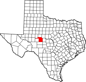 Tom Green County map | |
| CDPs | ||
| Other unincorporated communities | ||
| Ghost town | ||