National Register of Historic Places listings in Victoria County, Texas
This is a list of the National Register of Historic Places listings in Victoria County, Texas.

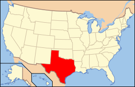
Location of Victoria County in Texas
This is intended to be a complete list of properties and districts listed on the National Register of Historic Places in Victoria County, Texas. There are one district and 114 individual properties listed on the National Register in the county. An additional property has since been delisted. Two properties are designated State Antiquities Landmarks while 26 are Recorded Texas Historic Landmarks.
- This National Park Service list is complete through NPS recent listings posted June 19, 2020.[1]
Current listings
The publicly disclosed locations of National Register properties and districts may be seen in a mapping service provided.[2]
| [3] | Name on the Register[4] | Image | Date listed[5] | Location | City or town | Description |
|---|---|---|---|---|---|---|
| 1 | C. R. Alden Building | 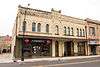 C. R. Alden Building |
December 9, 1986 (#86002533) |
106-110 W. Juan Linn 28°47′52″N 97°00′26″W |
Victoria | |
| 2 | Frank Alonso House |  Frank Alonso House |
December 9, 1986 (#86002585) |
401 S. Cameron 28°47′39″N 97°00′02″W |
Victoria | |
| 3 | B'nai Israel |  B'nai Israel |
December 9, 1986 (#86002613) |
604 N. Main 28°48′13″N 97°00′14″W |
Victoria | |
| 4 | Barden-O'Connor House |  Barden-O'Connor House |
December 9, 1986 (#86002609) |
305 N. Moody 28°48′09″N 97°00′30″W |
Victoria | |
| 5 | W. C. Barnes House | 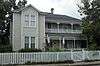 W. C. Barnes House |
December 9, 1986 (#86002568) |
106 W. Stayton 28°48′14″N 97°00′18″W |
Victoria | |
| 6 | E. H. D. Bendt House | 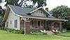 E. H. D. Bendt House |
December 9, 1986 (#86002570) |
407 S. DeLeon 28°47′42″N 97°00′17″W |
Victoria | |
| 7 | Max Bettin House |  Max Bettin House |
December 9, 1986 (#86002564) |
602 E. Santa Rosa 28°47′48″N 97°00′05″W |
Victoria | |
| 8 | Braman House | 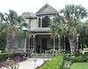 Braman House |
December 9, 1986 (#86002593) |
206 W. Stayton 28°48′15″N 97°00′21″W |
Victoria | |
| 9 | Theodore Buhler House |  Theodore Buhler House |
December 9, 1986 (#86002594) |
202 W. Stayton 28°48′14″N 97°00′19″W |
Victoria | |
| 10 | Building at 205 East Constitution |  Building at 205 East Constitution |
December 9, 1986 (#86002475) |
205 E. Constitution 28°47′55″N 97°00′17″W |
Victoria | |
| 11 | Burrough-Daniel House |  Burrough-Daniel House |
December 9, 1986 (#86002604) |
502 W. North 28°48′21″N 97°00′29″W |
Victoria | |
| 12 | Calhoun Bakery | December 9, 1986 (#86002534) |
209 N. Wheeler 28°47′58″N 97°00′06″W |
Victoria | Demolished[6] | |
| 13 | Callender House |  Callender House |
September 26, 1979 (#79003019) |
404 W. Guadelupe St 28°48′30″N 97°00′26″W |
Victoria | Recorded Texas Historic Landmark |
| 14 | City of Victoria Pumping Plant-Waterworks |  City of Victoria Pumping Plant-Waterworks |
December 9, 1986 (#86002610) |
105 W. Juan Linn 28°48′22″N 97°00′58″W |
Victoria | Recorded Texas Historic Landmark |
| 15 | Clark House |  Clark House |
December 9, 1986 (#86002507) |
606 S. Liberty 28°47′38″N 97°00′26″W |
Victoria | |
| 16 | Robert Clark House |  Robert Clark House |
December 9, 1986 (#86002615) |
317 N. Main 28°48′06″N 97°00′19″W |
Victoria | Recorded Texas Historic Landmark |
| 17 | John H. Clegg House |  John H. Clegg House |
December 9, 1986 (#86002548) |
507 N. Vine 28°48′17″N 97°00′30″W |
Victoria | |
| 18 | F. H. Crain House |  F. H. Crain House |
December 9, 1986 (#86002549) |
307 N. Vine 28°48′11″N 97°00′33″W |
Victoria | |
| 19 | DeLeon Plaza and Bandstand | .jpg) DeLeon Plaza and Bandstand |
March 24, 1987 (#86002584) |
100 blk. W. Constitution 28°47′59″N 97°00′23″W |
Victoria | Recorded Texas Historic Landmark |
| 20 | Diebel-Hyak House |  Diebel-Hyak House |
December 12, 1986 (#86002484) |
501 S. Cameron 28°47′36″N 97°00′03″W |
Victoria | |
| 21 | Farmers and Merchants Cotton Gin Warehouse |  Farmers and Merchants Cotton Gin Warehouse |
December 9, 1986 (#86002561) |
402 S. East 28°47′38″N 96°59′58″W |
Victoria | |
| 22 | Fleming-Welder House |  Fleming-Welder House |
December 9, 1986 (#86002581) |
607 N. Craig 28°48′22″N 97°00′36″W |
Victoria | Recorded Texas Historic Landmark |
| 23 | Fort St. Louis Site |  Fort St. Louis Site |
March 31, 1971 (#71000969) |
Address restricted[7] |
Inez | |
| 24 | Fossati's |  Fossati's |
May 20, 1991 (#91000578) |
302 S. Main 28°47′50″N 97°00′24″W |
Victoria | Recorded Texas Historic Landmark |
| 25 | E. J. Fossati House | December 9, 1986 (#86002563) |
607 S. DeLeon 28°47′36″N 97°00′20″W |
Victoria | ||
| 26 | Jacob Fox House |  Jacob Fox House |
December 9, 1986 (#86002596) |
708 W. Power 28°48′18″N 97°00′40″W |
Victoria | Recorded Texas Historic Landmark |
| 27 | Gaylord-Levy House |  Gaylord-Levy House |
December 9, 1986 (#86002589) |
402 N. Bridge 28°48′08″N 97°00′21″W |
Victoria | |
| 28 | Gervais House |  Gervais House |
July 5, 1990 (#90001052) |
507 W. Forrest 28°48′05″N 97°00′37″W |
Victoria | |
| 29 | Goldman's Cotton Gin Warehouse |  Goldman's Cotton Gin Warehouse |
December 9, 1986 (#86002606) |
901 E. Murray 28°47′32″N 97°00′00″W |
Victoria | |
| 30 | A. Goldman Building |  A. Goldman Building |
December 9, 1986 (#86002499) |
207 E. Constitution 28°47′55″N 97°00′17″W |
Victoria | |
| 31 | Gramann House |  Gramann House |
December 9, 1986 (#86002542) |
302 E. Goodwin 28°48′01″N 97°00′11″W |
Victoria | |
| 32 | George and Adele Hauschild House | December 9, 1986 (#86002510) |
208 N. Liberty 28°48′01″N 97°00′16″W |
Victoria | Demolished | |
| 33 | George H. Hauschild Building |  George H. Hauschild Building |
December 9, 1986 (#86002530) |
206 N. Liberty 28°48′01″N 97°00′17″W |
Victoria | Recorded Texas Historic Landmark |
| 34 | Hill-Howard House |  Hill-Howard House |
December 9, 1986 (#86002558) |
802 W. Power 28°48′18″N 97°00′42″W |
Victoria | Recorded Texas Historic Landmark |
| 35 | Hiller House |  Hiller House |
December 9, 1986 (#86002482) |
3003 N. Vine 28°49′18″N 97°00′33″W |
Victoria | Recorded Texas Historic Landmark |
| 36 | Hiller House | .JPG) Hiller House |
December 9, 1986 (#86002459) |
501 E. Church 28°47′42″N 97°00′12″W |
Victoria | |
| 37 | House at 304 West Stayton |  House at 304 West Stayton |
December 9, 1986 (#86002591) |
304 W. Stayton 28°48′16″N 97°00′24″W |
Victoria | |
| 38 | House at 306 East Forrest |  House at 306 East Forrest |
December 9, 1986 (#86002557) |
306 E. Forrest 28°47′56″N 97°00′08″W |
Victoria | |
| 39 | House at 401 East Stayton |  House at 401 East Stayton |
December 9, 1986 (#86002572) |
401 E. Stayton 28°48′08″N 97°00′03″W |
Victoria | |
| 40 | House at 402 W. Colorado |  House at 402 W. Colorado |
May 20, 1991 (#91000576) |
402 W. Colorado 28°48′33″N 97°00′27″W |
Victoria | |
| 41 | House at 407 East Convent |  House at 407 East Convent |
December 9, 1986 (#86002583) |
407 E. Convent 28°47′39″N 97°00′14″W |
Victoria | |
| 42 | House at 4402 East Juan Linn |  House at 4402 East Juan Linn |
December 9, 1986 (#86002535) |
4402 E. Juan Linn 28°47′01″N 96°57′51″W |
Victoria | |
| 43 | House at 604 East Santa Rosa |  House at 604 East Santa Rosa |
December 9, 1986 (#86002562) |
604 E. Santa Rosa 28°47′48″N 97°00′04″W |
Victoria | |
| 44 | House at 702 Siegfried |  House at 702 Siegfried |
December 9, 1986 (#86002577) |
702 Siegfried 28°47′31″N 97°00′58″W |
Victoria | |
| 45 | House at 706 Siegfried | December 9, 1986 (#86002576) |
706 Siegfried 28°47′31″N 97°00′59″W |
Victoria | Demolished between 2011 and 2013 | |
| 46 | House at 804 Siegfried |  House at 804 Siegfried |
December 9, 1986 (#86002574) |
804 Siegfried 28°47′30″N 97°01′04″W |
Victoria | |
| 47 | House at 1602 North Moody |  House at 1602 North Moody |
December 9, 1986 (#86002608) |
1602 N. Moody 28°48′33″N 97°00′26″W |
Victoria | |
| 48 | House at 1907 Southwest Ben Jordan |  House at 1907 Southwest Ben Jordan |
December 9, 1986 (#86002590) |
1907 S.W. Ben Jordan 28°47′14″N 96°59′19″W |
Victoria | |
| 49 | Hull House |  Hull House |
December 9, 1986 (#86002543) |
1002 NE Water 28°47′28″N 96°59′58″W |
Victoria | |
| 50 | E. J. Jecker House |  E. J. Jecker House |
December 9, 1986 (#86002539) |
201 N. Wheeler 28°47′56″N 97°00′07″W |
Victoria | |
| 51 | J. T. Jecker House |  J. T. Jecker House |
March 24, 1987 (#86002531) |
104 N. Liberty 28°47′57″N 97°00′18″W |
Victoria | Recorded Texas Historic Landmark |
| 52 | Jordan-Koch House |  Jordan-Koch House |
December 9, 1986 (#86002579) |
307 N. DeLeon 28°48′02″N 97°00′08″W |
Victoria | |
| 53 | E. C. Kaufman House |  E. C. Kaufman House |
December 9, 1986 (#86002567) |
502 S. DeLeon 28°47′40″N 97°00′17″W |
Victoria | |
| 54 | Keef-Filley Building |  Keef-Filley Building |
March 24, 1987 (#86002612) |
214 S. Main 28°47′52″N 97°00′24″W |
Victoria | |
| 55 | Lander-Hopkins House |  Lander-Hopkins House |
December 9, 1986 (#86002600) |
202 W. Power at N. Bridge 28°48′11″N 97°00′21″W |
Victoria | |
| 56 | Lane-Tarkington House |  Lane-Tarkington House |
December 9, 1986 (#86002617) |
1207 N. Bridge 28°48′22″N 97°00′17″W |
Victoria | |
| 57 | Lawrence House | .JPG) Lawrence House |
December 9, 1986 (#86002588) |
1203 N. Bridge 28°48′21″N 97°00′17″W |
Victoria | |
| 58 | Jules Leffland House |  Jules Leffland House |
May 20, 1991 (#91000577) |
302 E. Convent 28°47′43″N 97°00′19″W |
Victoria | |
| 59 | Levi-Welder House |  Levi-Welder House |
December 9, 1986 (#86002614) |
403 N. Main 28°48′09″N 97°00′18″W |
Victoria | Recorded Texas Historic Landmark |
| 60 | Little House |  Little House |
December 9, 1986 (#86002551) |
502 N. Victoria 28°48′16″N 97°00′33″W |
Victoria | |
| 61 | Vera Martin-Fiek-Thumford House |  Vera Martin-Fiek-Thumford House |
December 9, 1986 (#86002597) |
507 N. William 28°48′10″N 97°00′09″W |
Victoria | |
| 62 | McCabe Building |  McCabe Building |
December 19, 1986 (#86002464) |
508 N. Wheeler 28°48′07″N 97°00′01″W |
Victoria | |
| 63 | McCan-Nave House |  McCan-Nave House |
December 9, 1986 (#86002555) |
401 N. Glass 28°48′09″N 97°00′25″W |
Victoria | |
| 64 | McDonald House | .JPG) McDonald House |
December 9, 1986 (#86002460) |
406 E. Constitution 28°47′53″N 97°00′09″W |
Victoria | |
| 65 | James McFaddin House |  James McFaddin House |
March 24, 1987 (#86002506) |
207 W. Commercial 28°48′08″N 97°00′25″W |
Victoria | Recorded Texas Historic Landmark |
| 66 | McNamara-O'Conner House |  McNamara-O'Conner House |
December 9, 1986 (#86002509) |
502 N. Liberty 28°48′09″N 97°00′12″W |
Victoria | Recorded Texas Historic Landmark |
| 67 | Mission Creek Dam and Acequia Site | Mission Creek Dam and Acequia Site |
April 9, 1980 (#80004157) |
Address restricted[7] |
Victoria | |
| 68 | Guy Mitchell House |  Guy Mitchell House |
December 9, 1986 (#86002541) |
402 W. Goodwin 28°48′07″N 97°00′31″W |
Victoria | |
| 69 | Moeller House | December 9, 1986 (#86002559) |
901 S. East 28°47′22″N 97°00′05″W |
Victoria | Demolished | |
| 70 | Mohris-Abschier House |  Mohris-Abschier House |
December 9, 1986 (#86002580) |
101 N. DeLeon 28°47′54″N 97°00′12″W |
Victoria | |
| 71 | Mrs. J. V. Murphy House |  Mrs. J. V. Murphy House |
December 9, 1986 (#86002554) |
204 E. Santa Rosa 28°47′53″N 97°00′18″W |
Victoria | |
| 72 | Royston Nave Memorial |  Royston Nave Memorial |
December 9, 1986 (#86002502) |
306 W. Commercial 28°48′10″N 97°00′28″W |
Victoria | |
| 73 | Thomas M. O'Connor House |  Thomas M. O'Connor House |
December 9, 1986 (#86002587) |
303 S. Bridge 28°47′51″N 97°00′30″W |
Victoria | |
| 74 | O'Connor-Proctor Building |  O'Connor-Proctor Building |
December 9, 1986 (#86002546) |
202 N. Main 28°48′00″N 97°00′20″W |
Victoria | Recorded Texas Historic Landmark |
| 75 | Old Brownson School |  Old Brownson School |
December 9, 1986 (#86002598) |
500 blk. of W. Power 28°48′14″N 97°00′33″W |
Victoria | |
| 76 | Old Federal Building and Post Office | 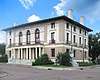 Old Federal Building and Post Office |
December 9, 1986 (#86002493) |
210 E. Constitution 28°47′55″N 97°00′15″W |
Victoria | Recorded Texas Historic Landmark |
| 77 | Old Municipal Assembly Hall | December 9, 1986 (#86002603) |
800 E. Pine 28°48′12″N 96°59′45″W |
Victoria | Demolished | |
| 78 | Old Nazareth Academy | 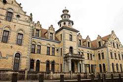 Old Nazareth Academy |
December 9, 1986 (#86002462) |
105 W. Church 28°47′48″N 97°00′28″W |
Victoria | |
| 79 | Old Victoria County Courthouse |  Old Victoria County Courthouse |
August 18, 1977 (#77001479) |
101 N. Bridge St. 28°47′59″N 97°00′26″W |
Victoria | State Antiquities Landmark, Recorded Texas Historic Landmark |
| 80 | Our Lady of Lourdes Church | 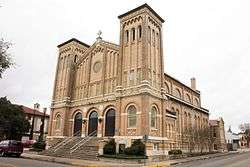 Our Lady of Lourdes Church |
December 9, 1986 (#86002601) |
105 N. William 28°47′57″N 97°00′14″W |
Victoria | |
| 81 | Pela House |  Pela House |
December 9, 1986 (#86002552) |
309 E. Santa Rosa 28°47′50″N 97°00′14″W |
Victoria | Recorded Texas Historic Landmark |
| 82 | Judge Alexander H. Phillips House |  Judge Alexander H. Phillips House |
November 3, 1983 (#83003824) |
705 N. Craig St. 28°48′25″N 97°00′36″W |
Victoria | Recorded Texas Historic Landmark |
| 83 | Pickering House |  Pickering House |
December 9, 1986 (#86002553) |
403 N. Glass 28°48′11″N 97°00′25″W |
Victoria | |
| 84 | Pippert House | December 9, 1986 (#86002578) |
207 E. Third 28°47′30″N 97°00′28″W |
Victoria | Demolished | |
| 85 | Presbyterian Iglesia Nicea | 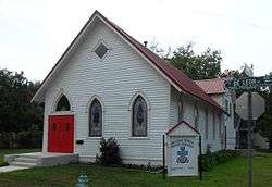 Presbyterian Iglesia Nicea |
October 28, 1992 (#86002571) |
401 S. DeLeon 28°47′44″N 97°00′16″W |
Victoria | |
| 86 | Proctor House |  Proctor House |
December 6, 1986 (#86002544) |
507 N. Glass 28°48′14″N 97°00′23″W |
Victoria | Recorded Texas Historic Landmark |
| 87 | Proctor-Vandenberge House |  Proctor-Vandenberge House |
December 9, 1986 (#86002575) |
604 N. Craig 28°48′22″N 97°00′36″W |
Victoria | Recorded Texas Historic Landmark |
| 88 | Randall Building | 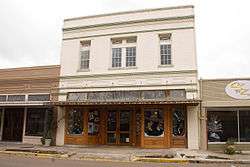 Randall Building |
December 9, 1986 (#86002560) |
103-105 W. Santa Rosa 28°47′54″N 97°00′25″W |
Victoria | |
| 89 | D. H. Regan House | 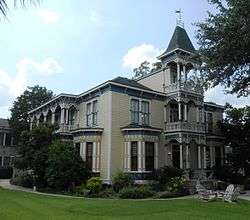 D. H. Regan House |
December 9, 1986 (#86002565) |
507 S. DeLeon 28°47′39″N 97°00′18″W |
Victoria | Recorded Texas Historic Landmark |
| 90 | Roselle-Smith House | 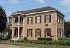 Roselle-Smith House |
July 5, 1990 (#90001050) |
301 E. Commercial 28°48′03″N 97°00′11″W |
Victoria | |
| 91 | Saint Mary's Catholic Church |  Saint Mary's Catholic Church |
December 9, 1986 (#86002450) |
101 W. Church 28°47′48″N 97°00′27″W |
Victoria | Recorded Texas Historic Landmark |
| 92 | Schroeder House |  Schroeder House |
December 9, 1986 (#86002545) |
1507 N. Vine 28°48′32″N 97°00′30″W |
Victoria | |
| 93 | Schummacker Company Building | Schummacker Company Building |
December 9, 1986 (#86002602) |
402 E. Power 28°48′06″N 97°00′05″W |
Victoria | State Antiquities Landmark |
| 94 | Alphonse T. Sengele House |  Alphonse T. Sengele House |
October 28, 1992 (#86002538) |
502 E. Juan Linn 28°47′46″N 97°00′10″W |
Victoria | |
| 95 | Henry Shrader House | 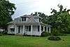 Henry Shrader House |
December 9, 1986 (#86002483) |
607 S. Cameron 28°47′31″N 97°00′06″W |
Victoria | |
| 96 | Sigmund House |  Sigmund House |
December 9, 1986 (#86002566) |
508 E. Santa Rosa 28°47′49″N 97°00′06″W |
Victoria | |
| 97 | South Bridge Street Historic District |  South Bridge Street Historic District |
September 24, 1986 (#86002592) |
W side 700 blk. of S. Bridge and N side 200 blk. of W. Water Sts. 28°47′37″N 97°00′35″W |
Victoria | |
| 98 | Stuart House |  Stuart House |
December 9, 1986 (#86002586) |
506 S. Bridge 28°47′44″N 97°00′31″W |
Victoria | |
| 99 | Tasin House |  Tasin House |
December 9, 1986 (#86002536) |
202 N. Wheeler 28°47′56″N 97°00′06″W |
Victoria | |
| 100 | Texas Company Filling Station | December 9, 1986 (#86002595) |
102 S. Williams St. 28°47′54″N 97°00′15″W |
Victoria | Demolished | |
| 101 | Tonkawa Bank Site | Tonkawa Bank Site |
February 13, 1981 (#81000634) |
Address restricted[7] |
Victoria | 41 VT 10 |
| 102 | Townsend-Wilkins House |  Townsend-Wilkins House |
December 9, 1986 (#86002605) |
106 N. Navarro 28°47′53″N 97°00′03″W |
Victoria | |
| 103 | Trinity Lutheran Church | .jpg) Trinity Lutheran Church |
December 9, 1986 (#86002486) |
402 E. Constitution 28°47′53″N 97°00′10″W |
Victoria | |
| 104 | Fred Urban House |  Fred Urban House |
October 28, 1992 (#86002556) |
501 E. River 28°47′33″N 97°00′15″W |
Victoria | |
| 105 | J. V. Vandenberge House |  J. V. Vandenberge House |
December 9, 1986 (#86002550) |
301 N. Vine 28°48′09″N 97°00′34″W |
Victoria | |
| 106 | Victoria Colored School |  Victoria Colored School |
December 9, 1986 (#86002582) |
702 E. Convent 28°47′38″N 97°00′05″W |
Victoria | |
| 107 | Victoria County Monument | 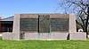 Victoria County Monument |
July 27, 2018 (#100002760) |
402 N DeLeon St., Memorial Square Park 28°48′05″N 97°00′05″W |
Victoria | |
| 108 | Victoria Grist Windmill | 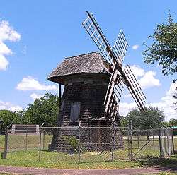 Victoria Grist Windmill |
April 30, 1976 (#76002079) |
Memorial Park in Victoria 28°48′03″N 97°00′05″W |
Victoria | Recorded Texas Historic Landmark |
| 109 | Weber-Schuchert House |  Weber-Schuchert House |
December 9, 1986 (#86002490) |
302 E. Constitution 28°47′55″N 97°00′14″W |
Victoria | |
| 110 | Webster Chapel United Methodist Church | 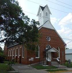 Webster Chapel United Methodist Church |
December 9, 1986 (#86002478) |
405 S. Wheeler 28°47′41″N 97°00′13″W |
Victoria | |
| 111 | Robert H. Welder House |  Robert H. Welder House |
March 12, 1999 (#86003843) |
210 E. Juan Linn 28°47′49″N 97°00′18″W |
Victoria | |
| 112 | William Wheeler House | 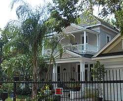 William Wheeler House |
December 9, 1986 (#86002599) |
303 N. William St. 28°48′02″N 97°00′12″W |
Victoria | |
| 113 | Willeke Site | Willeke Site |
November 20, 1978 (#78002997) |
Address restricted[7] |
Victoria | 41VT16 |
| 114 | B. F. Williams House |  B. F. Williams House |
December 9, 1986 (#86002607) |
401 E. Murray 28°47′37″N 97°00′18″W |
Victoria | Recorded Texas Historic Landmark |
| 115 | Woodhouse House |  Woodhouse House |
December 9, 1986 (#86002481) |
609 N. Wheeler 28°48′11″N 97°00′01″W |
Victoria | Recorded Texas Historic Landmark |
| 116 | Herman and Alvina Zahn House | December 9, 1986 (#86002573) |
310 S. Wheeler St. 28°47′43″N 97°00′11″W |
Victoria | Relocated in 2014 [8] |
Former listing
| [3] | Name on the Register | Image | Date listed | Date removed | Location | City or town | Summary |
|---|---|---|---|---|---|---|---|
| 1 | Krenek House | December 9, 1986 (#86002611) | July 19, 2010 | 607 N. Main 28°48′15″N 97°00′14″W |
Victoria | Demolished April 9–10, 2010.[9] |
See also
References
- "National Register of Historic Places: Weekly List Actions". National Park Service, United States Department of the Interior. Retrieved on June 19, 2020.
- The latitude and longitude information provided in this table was derived originally from the National Register Information System, which has been found to be fairly accurate for about 99% of listings. Some locations in this table may have been corrected to current GPS standards.
- Numbers represent an ordering by significant words. Various colorings, defined here, differentiate National Historic Landmarks and historic districts from other NRHP buildings, structures, sites or objects.
- "National Register Information System". National Register of Historic Places. National Park Service. July 9, 2010.
- The eight-digit number below each date is the number assigned to each location in the National Register Information System database, which can be viewed by clicking the number.
- Victoria Advocate
- Federal and state laws and practices restrict general public access to information regarding the specific location of this resource. In some cases, this is to protect archeological sites from vandalism, while in other cases it is restricted at the request of the owner. See: Knoerl, John; Miller, Diane; Shrimpton, Rebecca H. (1990), Guidelines for Restricting Information about Historic and Prehistoric Resources, National Register Bulletin, National Park Service, U.S. Department of the Interior, OCLC 20706997.
- Vanished from Victoria: Dr. J. F. Krenek house, 607 N. Main St.
External links
![]()
Places adjacent to National Register of Historic Places listings in Victoria County, Texas | ||||||||||
|---|---|---|---|---|---|---|---|---|---|---|
| ||||||||||
Municipalities and communities of Victoria County, Texas, United States | ||
|---|---|---|
| City | 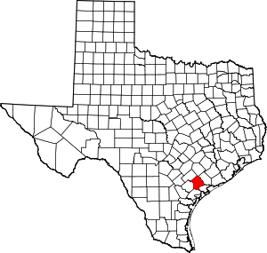 Victoria County map | |
| CDPs | ||
| Other unincorporated communities | ||
This article is issued from Wikipedia. The text is licensed under Creative Commons - Attribution - Sharealike. Additional terms may apply for the media files.