National Register of Historic Places listings in Big Bend National Park
This is a list of the National Register of Historic Places listings in Big Bend National Park.
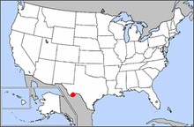
Location of Big Bend National Park in the United States
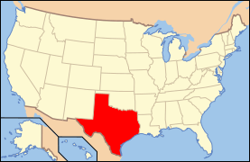
This is intended to be a complete list of the properties and districts on the National Register of Historic Places in Big Bend National Park, Brewster County, Texas. There are six districts and three individual properties listed on the National Register within the park.
- This National Park Service list is complete through NPS recent listings posted June 26, 2020.[1]
Current listings
The publicly disclosed locations of National Register properties and districts may be seen in a mapping service provided.[2]
| [3] | Name on the Register | Image | Date listed[4] | Location | City or town | Description |
|---|---|---|---|---|---|---|
| 1 | Burro Mesa Archeological District | 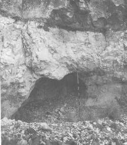 Burro Mesa Archeological District |
September 11, 1985 (#85002309) |
Address restricted[5] |
Panther Junction | |
| 2 | Castolon Historic District |  Castolon Historic District |
September 6, 1974 (#74000276) |
Along Rio Grande at jct. of Park Rtes. 5, 9, and 35 29°08′03″N 103°30′51″W |
Big Bend National Park | |
| 3 | Daniels Farm House | 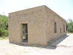 Daniels Farm House |
October 20, 1989 (#89001627) |
W of Rio Grande Village in Big Bend National Park 29°11′08″N 102°58′18″W |
Rio Grande Village | |
| 4 | Hot Springs |  Hot Springs |
September 17, 1974 (#74000278) |
W of Rio Grande Village 29°10′45″N 102°59′42″W |
Big Bend National Park | |
| 5 | Luna Jacal | 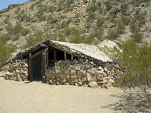 Luna Jacal |
November 8, 1974 (#74000282) |
At base of Pena Mountain in Big Bend National Park 29°12′55″N 103°32′04″W |
Big Bend National Park | |
| 6 | Mariscal Mine | 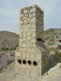 Mariscal Mine |
September 13, 1974 (#74000279) |
River Rd. 29°05′42″N 103°11′17″W |
Big Bend National Park | |
| 7 | Panther Junction Mission 66 Historic District | Panther Junction Mission 66 Historic District |
September 19, 2014 (#14000626) |
P.O. Box 129 29°19′40″N 103°12′21″W |
Big Bend National Park | |
| 8 | Rancho Estelle | 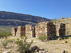 Rancho Estelle |
September 3, 1974 (#74000280) |
On the Rio Grande 29°09′20″N 103°34′35″W |
Big Bend National Park | |
| 9 | Homer Wilson Ranch | 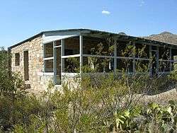 Homer Wilson Ranch |
April 14, 1975 (#75000153) |
8 mi. S of Santa Elena Junction on Park Rte. 5, Big Bend National Park 29°12′50″N 103°22′00″W |
Santa Elena Junction |
See also
References
- "National Register of Historic Places: Weekly List Actions". National Park Service, United States Department of the Interior. Retrieved on June 26, 2020.
- The latitude and longitude information provided in this table was derived originally from the National Register Information System, which has been found to be fairly accurate for about 99% of listings. Some locations in this table may have been corrected to current GPS standards.
- Numbers represent an ordering by significant words. Various colorings, defined here, differentiate National Historic Landmarks and historic districts from other NRHP buildings, structures, sites or objects.
- The eight-digit number below each date is the number assigned to each location in the National Register Information System database, which can be viewed by clicking the number.
- Federal and state laws and practices restrict general public access to information regarding the specific location of this resource. In some cases, this is to protect archeological sites from vandalism, while in other cases it is restricted at the request of the owner. See: Knoerl, John; Miller, Diane; Shrimpton, Rebecca H. (1990), Guidelines for Restricting Information about Historic and Prehistoric Resources, National Register Bulletin, National Park Service, U.S. Department of the Interior, OCLC 20706997.
External links
![]()
This article is issued from Wikipedia. The text is licensed under Creative Commons - Attribution - Sharealike. Additional terms may apply for the media files.