National Register of Historic Places listings in Taylor County, Texas
This is a list of the National Register of Historic Places listings in Taylor County, Texas.
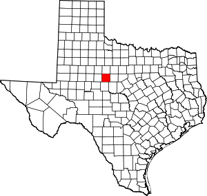
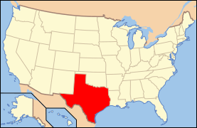
Location of Taylor County in Texas
This is intended to be a complete list of the properties and districts on the National Register of Historic Places in Taylor County, Texas. There are five districts and 54 individual properties along with three former properties listed on the National Register in the county. Among these are one State Antiquities Landmark, six Recorded Texas Historic Landmarks, plus an additional RTHL that is a contributing property to a historic district.
- This National Park Service list is complete through NPS recent listings posted June 26, 2020.[1]
Current listings
The locations of National Register properties and districts may be seen in a mapping service provided.[2]
| [3] | Name on the Register | Image | Date listed[4] | Location | City or town | Description |
|---|---|---|---|---|---|---|
| 1 | 1915 Taylor County Courthouse |  1915 Taylor County Courthouse |
March 23, 1992 (#92000225) |
301 Oak St. 32°26′45″N 99°43′55″W |
Abilene | State Antiquities Landmark |
| 2 | Abilene and Northern Railway Company Depot | 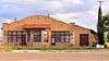 Abilene and Northern Railway Company Depot |
May 28, 2004 (#92000191) |
189 Locust St. 32°26′51″N 99°43′47″W |
Abilene | |
| 3 | Abilene Christian College Administration Building |  Abilene Christian College Administration Building |
March 23, 1992 (#92000193) |
Campus Court Dr., Abilene Christian University 32°28′01″N 99°42′37″W |
Abilene | |
| 4 | Abilene Commercial Historic District | 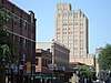 Abilene Commercial Historic District |
December 18, 1991 (#91001811) |
Roughly bounded by Hickory, N. 3rd, and Pine Sts. and the southern side of the Missouri Pacific railroad tracks 32°27′01″N 99°44′01″W |
Abilene | Includes Recorded Texas Historic Landmark |
| 5 | Abilene Courts | .jpg) Abilene Courts |
June 3, 2015 (#15000338) |
633 S. 11th St. 32°26′13″N 99°43′51″W |
Abilene | |
| 6 | Abilene Fire Station No. 2 | .jpg) Abilene Fire Station No. 2 |
March 23, 1992 (#92000200) |
441 Butternut 32°26′41″N 99°44′15″W |
Abilene | |
| 7 | Abilene High School | .jpg) Abilene High School |
August 28, 2012 (#12000588) |
1699 South 1st Street 32°26′53″N 99°44′32″W |
Abilene | |
| 8 | Abilene Street Railway Company Barn | 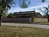 Abilene Street Railway Company Barn |
March 23, 1992 (#92000205) |
1037 Clinton St. 32°27′41″N 99°44′37″W |
Abilene | |
| 9 | William and Mary Ackers House | 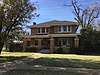 William and Mary Ackers House |
March 23, 1992 (#92000214) |
802 Mulberry St. 32°27′26″N 99°44′24″W |
Abilene | |
| 10 | Alexander-Campbell House | 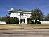 Alexander-Campbell House |
March 29, 1996 (#96000308) |
1546 N. 5th St. 32°27′16″N 99°44′23″W |
Abilene | |
| 11 | Bankhead Highway Historic District | December 3, 1998 (#98001414) |
Approximately 4 mi (6.4 km). sections of former US 80 contained within Taylor County 32°27′43″N 99°54′21″W |
Abilene | ||
| 12 | Thomas L. Blanton House |  Thomas L. Blanton House |
March 23, 1992 (#92000234) |
3425 S. Seventh St. 32°26′36″N 99°45′59″W |
Abilene | |
| 13 | Boyd-Hall House | 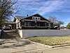 Boyd-Hall House |
March 23, 1992 (#92000229) |
502 Poplar St. 32°26′40″N 99°44′22″W |
Abilene | |
| 14 | Caldwell Hall | 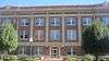 Caldwell Hall |
March 23, 1992 (#92000206) |
Intracampus Dr., Hardin-Simmons University 32°28′39″N 99°44′07″W |
Abilene | |
| 15 | W. A. V. Cash House |  W. A. V. Cash House |
March 23, 1992 (#92000195) |
1302 Amarillo 32°26′04″N 99°44′49″W |
Abilene | |
| 16 | David S. Castle House | 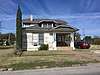 David S. Castle House |
March 23, 1992 (#92000218) |
1742 N. Second St. 32°27′04″N 99°44′33″W |
Abilene | |
| 17 | George R. Davis House | .jpg) George R. Davis House |
March 23, 1992 (#92000237) |
718 Victoria 32°27′25″N 99°44′45″W |
Abilene | |
| 18 | O. D. and Ada Dillingham House | 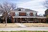 O. D. and Ada Dillingham House |
March 23, 1992 (#92000199) |
1625 Belmont 32°25′45″N 99°44′13″W |
Abilene | |
| 19 | Dodd-Harkrider House | .jpg) Dodd-Harkrider House |
March 23, 1992 (#92000222) |
2026 N. Third St. 32°27′11″N 99°44′46″W |
Abilene | |
| 20 | J. W. Evans House | .jpg) J. W. Evans House |
March 23, 1992 (#92000204) |
258 Clinton St. 32°27′09″N 99°44′40″W |
Abilene | |
| 21 | Federal Building | .jpg) Federal Building |
July 20, 1992 (#92000228) |
341 Pine 32°27′07″N 99°43′55″W |
Abilene | |
| 22 | Eugene L. Finley House | 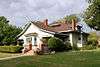 Eugene L. Finley House |
March 23, 1992 (#92000210) |
208 Merchant 32°27′06″N 99°44′35″W |
Abilene | |
| 23 | First Presbyterian Church | .jpg) First Presbyterian Church |
March 23, 1992 (#92000226) |
402 Orange St. 32°27′11″N 99°44′17″W |
Abilene | |
| 24 | David C. and Docia Fritz House | 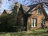 David C. and Docia Fritz House |
March 23, 1992 (#92000215) |
1325 N. Eighteenth St. 32°28′11″N 99°44′06″W |
Abilene | |
| 25 | William J. Fulwiler House | November 26, 2018 (#92000192) |
910 Highland St. 32°26′20″N 99°44′58″W |
Abilene | ||
| 26 | Albert S. and Ruth Goodloe House | 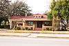 Albert S. and Ruth Goodloe House |
March 23, 1992 (#92000232) |
1302 Sayles Blvd. 32°26′00″N 99°44′53″W |
Abilene | |
| 27 | Roland A. D. Green House |  Roland A. D. Green House |
March 23, 1992 (#92000207) |
1358 Highland St. 32°26′04″N 99°44′54″W |
Abilene | |
| 28 | J. G. Higginbotham House | .jpg) J. G. Higginbotham House |
March 23, 1992 (#92000236) |
2102 Swenson 32°28′23″N 99°44′27″W |
Abilene | |
| 29 | Hilton Hotel | .jpg) Hilton Hotel |
December 23, 1993 (#85003658) |
986 N. Fourth St. 32°27′10″N 99°43′57″W |
Abilene | |
| 30 | Ed S. Hughes Company Warehouse | March 23, 1992 (#92000224) |
135 Oak St. 32°26′52″N 99°43′56″W |
Abilene | ||
| 31 | A. T. Jones House | 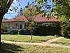 A. T. Jones House |
March 23, 1992 (#92000212) |
418 Merchant 32°27′15″N 99°44′36″W |
Abilene | |
| 32 | C. A. Lanius House | .jpg) C. A. Lanius House |
March 23, 1992 (#92000221) |
1942 N. Third St. 32°27′11″N 99°44′41″W |
Abilene | |
| 33 | Luce Hall | .jpg) Luce Hall |
March 23, 1992 (#92000194) |
Campus Court Dr., north of Administration Building, Abilene Christian University 32°27′59″N 99°42′38″W |
Abilene | |
| 34 | J. D. Magee House | .jpg) J. D. Magee House |
March 23, 1992 (#92000220) |
1910 N. Third St. 32°27′11″N 99°44′33″W |
Abilene | Recorded Texas Historic Landmark |
| 35 | George W. and Lavina McDaniel House | .jpg) George W. and Lavina McDaniel House |
March 23, 1992 (#92000201) |
774 Butternut 32°26′28″N 99°44′17″W |
Abilene | |
| 36 | McDonald Hall |  McDonald Hall |
March 23, 1992 (#92000219) |
2083 N. Second St. 32°27′05″N 99°44′36″W |
Abilene | |
| 37 | McMurry College Administration Building | 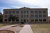 McMurry College Administration Building |
March 23, 1992 (#92000209) |
Off Hunt, McMurry College 32°25′45″N 99°45′04″W |
Abilene | |
| 38 | William A. Minter House | .jpg) William A. Minter House |
March 23, 1992 (#92000198) |
340 Beech St. 32°27′08″N 99°44′20″W |
Abilene | |
| 39 | Charles Motz House | .jpg) Charles Motz House |
March 23, 1992 (#92000216) |
1842 N. Fifth St. 32°27′16″N 99°44′36″W |
Abilene | |
| 40 | Old Taylor County Courthouse and Jail | .jpg) Old Taylor County Courthouse and Jail |
June 9, 1978 (#78002984) |
William St. between North and Elm Sts. 32°17′10″N 99°49′36″W |
Buffalo Gap | Recorded Texas Historic Landmark |
| 41 | Paramount Theater | .jpg) Paramount Theater |
December 27, 1982 (#82001739) |
352 Cypress St. 32°27′08″N 99°44′02″W |
Abilene | |
| 42 | Parramore Historic District | .jpg) Parramore Historic District |
August 29, 1991 (#91001153) |
Bounded by Orange, N. 8th, alley between Grape and Mulberry, and N. 7th Sts. 32°27′25″N 99°44′18″W |
Abilene | |
| 43 | D. D. Parramore House | 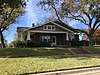 D. D. Parramore House |
March 23, 1992 (#92000230) |
542 Poplar St. 32°26′38″N 99°44′18″W |
Abilene | |
| 44 | Jhules Reading House | March 23, 1992 (#92000231) |
421 Reading St. 32°27′13″N 99°44′31″W |
Abilene | ||
| 45 | Nathan J. and Nancy Roberts House | March 23, 1992 (#92000235) |
1430 S. Sixth St. 32°26′38″N 99°44′22″W |
Abilene | ||
| 46 | Sacred Heart Catholic Church |  Sacred Heart Catholic Church |
March 23, 1992 (#92000233) |
1633 S. Eighth St. 32°26′27″N 99°44′32″W |
Abilene | Recorded Texas Historic Landmark |
| 47 | Sayles Boulevard Historic District | .jpg) Sayles Boulevard Historic District |
March 9, 1992 (#92000095) |
Roughly bounded by S. Fifth, Meander and S. Tenth Sts. and Highland Ave. 32°26′31″N 99°44′50″W |
Abilene | Includes Recorded Texas Historic Landmark |
| 48 | Henry Sayles House |  Henry Sayles House |
June 24, 1976 (#76002069) |
642 Sayles Blvd. 32°26′37″N 99°44′53″W |
Abilene | Recorded Texas Historic Landmark |
| 49 | State Epileptic Colony Historic District | October 30, 1991 (#91001539) |
Roughly bounded by S. 24th, Lakeside and Plum, also area roughly bounded by SH 322, FM 1750 and Industrial Blvd. 32°24′45″N 99°42′58″W |
Abilene | ||
| 50 | William and Evla Stith House |  William and Evla Stith House |
March 23, 1992 (#92000213) |
346 Mulberry St. 32°27′09″N 99°44′24″W |
Abilene | |
| 51 | William and Shirley Swenson House |  William and Shirley Swenson House |
December 22, 1987 (#87002148) |
1726 Swenson Ave. 32°28′10″N 99°44′28″W |
Abilene | Recorded Texas Historic Landmark |
| 52 | Oscar P. Thomas House | .jpg) Oscar P. Thomas House |
March 23, 1992 (#92000203) |
210 Clinton St. 32°27′06″N 99°44′40″W |
Abilene | |
| 53 | U.S. Weather Bureau Building | .jpg) U.S. Weather Bureau Building |
July 8, 1982 (#82004524) |
1482 N. 1st St. 32°27′00″N 99°44′20″W |
Abilene | Recorded Texas Historic Landmark |
| 54 | Universal Manufacturing Company Building | .jpg) Universal Manufacturing Company Building |
March 23, 1992 (#92000208) |
150 Locust St. 32°26′51″N 99°43′47″W |
Abilene | |
| 55 | West Texas Utilities Company Power Plant |  West Texas Utilities Company Power Plant |
March 23, 1992 (#92000217) |
100 Block of N. Second St. 32°27′03″N 99°43′19″W |
Abilene | |
| 56 | E. D. Williamson House |  E. D. Williamson House |
March 23, 1992 (#92000202) |
641 Chestnut St. 32°26′33″N 99°44′01″W |
Abilene | |
| 57 | Horace O. Wooten Grocery Company Warehouse |  Horace O. Wooten Grocery Company Warehouse |
March 23, 1992 (#92000238) |
101 Walnut 32°26′58″N 99°43′51″W |
Abilene | |
| 58 | Horace O. Wooten House |  Horace O. Wooten House |
March 23, 1992 (#92000197) |
242 Beech St. 32°27′04″N 99°44′20″W |
Abilene | |
| 59 | Zabloudil-Hendrick House |  Zabloudil-Hendrick House |
March 23, 1992 (#92000227) |
802 Orange St. 32°27′28″N 99°44′15″W |
Abilene |
Former listing
| [3] | Name on the Register | Image | Date listed | Date removed | Location | City or town | Summary |
|---|---|---|---|---|---|---|---|
| 1 | Samuel A. Chambers House | March 23, 1992 (#92000211) | December 24, 2013 | 224 Merchant 32°27′07″N 99°44′35″W |
Abilene | ||
| 2 | House at 1127 Ash Street | March 23, 1992 (#92000196) | May 8, 2017 | 1127 Ash St. 32°27′42″N 99°43′36″W |
Abilene | ||
| 3 | James M. Radford Grocery Company Warehouse | March 23, 1992 (#92000223) | May 8, 2017 | 101 Oak St. 32°26′53″N 99°43′56″W |
Abilene |
See also
References
- "National Register of Historic Places: Weekly List Actions". National Park Service, United States Department of the Interior. Retrieved on June 26, 2020.
- The latitude and longitude information provided in this table was derived originally from the National Register Information System, which has been found to be fairly accurate for about 99% of listings. Some locations in this table may have been corrected to current GPS standards.
- Numbers represent an ordering by significant words. Various colorings, defined here, differentiate National Historic Landmarks and historic districts from other NRHP buildings, structures, sites or objects.
- The eight-digit number below each date is the number assigned to each location in the National Register Information System database, which can be viewed by clicking the number.
External links
![]()
Places adjacent to National Register of Historic Places listings in Taylor County, Texas | ||||||||||
|---|---|---|---|---|---|---|---|---|---|---|
| ||||||||||
Municipalities and communities of Taylor County, Texas, United States | ||
|---|---|---|
| Cities | Taylor County map | |
| Towns | ||
| CDP | ||
| Other unincorporated communities | ||
| Footnotes | ‡This populated place also has portions in an adjacent county or counties | |
This article is issued from Wikipedia. The text is licensed under Creative Commons - Attribution - Sharealike. Additional terms may apply for the media files.