National Register of Historic Places listings in Palo Pinto County, Texas
This is a list of the National Register of Historic Places listings in Palo Pinto County, Texas.
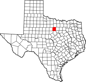
Location of Palo Pinto County in Texas
This is intended to be a complete list of properties listed on the National Register of Historic Places in Palo Pinto County, Texas. There are eight properties listed on the National Register in the county. One property is also a Recorded Texas Historic Landmark.
- This National Park Service list is complete through NPS recent listings posted June 19, 2020.[1]
Current listings
The locations of National Register properties may be seen in a mapping service provided.[2]
| [3] | Name on the Register | Image | Date listed[4] | Location | City or town | Description |
|---|---|---|---|---|---|---|
| 1 | Baker Hotel | .jpg) Baker Hotel |
June 23, 1982 (#82004518) |
200 E. Hubbard St. 32°48′35″N 98°06′00″W |
Mineral Wells | |
| 2 | First Presbyterian Church | .jpg) First Presbyterian Church |
June 14, 1979 (#79003004) |
410 NW 2nd St. 32°48′41″N 98°06′56″W |
Mineral Wells | |
| 3 | Gallagher House | .jpg) Gallagher House |
April 27, 2011 (#11000232) |
2919 Union Hill Rd 32°52′51″N 98°08′51″W |
Mineral Wells vicinity | |
| 4 | Palo Pinto County Courthouse | .jpg) Palo Pinto County Courthouse |
April 17, 1997 (#97000365) |
520 Oak St. 32°46′03″N 98°17′57″W |
Palo Pinto | |
| 5 | Palo Pinto County Jail | 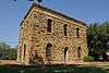 Palo Pinto County Jail |
September 26, 1979 (#79003005) |
Elm St. and 5th Ave 32°45′24″N 98°17′53″W |
Palo Pinto | |
| 6 | State Highway 16, Brazos River Bridge Segment |  State Highway 16, Brazos River Bridge Segment |
April 14, 2015 (#15000153) |
TX 16 from 7.4 mi. northeast of US 180 to junction of TX 16 & TX 254 32°52′31″N 98°24′44″W |
Graford vicinity | |
| 7 | US 281 Bridge at the Brazos River | 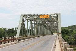 US 281 Bridge at the Brazos River |
October 10, 1996 (#96001126) |
US 281, 2.2 mi (3.5 km) north of Interstate 20 32°38′29″N 98°06′00″W |
Santo | |
| 8 | Weatherford-Mineral Wells and Northwestern Railroad Depot | 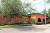 Weatherford-Mineral Wells and Northwestern Railroad Depot |
January 5, 1984 (#84001953) |
S. Oak St. 32°48′22″N 98°06′41″W |
Mineral Wells | Recorded Texas Historic Landmark |
See also
References
- "National Register of Historic Places: Weekly List Actions". National Park Service, United States Department of the Interior. Retrieved on June 19, 2020.
- The latitude and longitude information provided in this table was derived originally from the National Register Information System, which has been found to be fairly accurate for about 99% of listings. Some locations in this table may have been corrected to current GPS standards.
- Numbers represent an ordering by significant words. Various colorings, defined here, differentiate National Historic Landmarks and historic districts from other NRHP buildings, structures, sites or objects.
- The eight-digit number below each date is the number assigned to each location in the National Register Information System database, which can be viewed by clicking the number.
External links
![]()
Municipalities and communities of Palo Pinto County, Texas, United States | ||
|---|---|---|
| Cities | Palo Pinto County map | |
| CDP | ||
| Other unincorporated communities | ||
| Footnotes | ‡This populated place also has portions in an adjacent county or counties | |
This article is issued from Wikipedia. The text is licensed under Creative Commons - Attribution - Sharealike. Additional terms may apply for the media files.