National Register of Historic Places listings in Greenup County, Kentucky
This is a list of the National Register of Historic Places listings in Greenup County, Kentucky.

Location of Greenup County in Kentucky
This is intended to be a complete list of the properties and districts on the National Register of Historic Places in Greenup County, Kentucky, United States. The locations of National Register properties and districts for which the latitude and longitude coordinates are included below, may be seen in a map.[1]
There are 20 properties and districts listed on the National Register in the county.
- This National Park Service list is complete through NPS recent listings posted June 19, 2020.[2]
Current listings
| [3] | Name on the Register | Image | Date listed[4] | Location | City or town | Description |
|---|---|---|---|---|---|---|
| 1 | Bennett's Mill Covered Bridge | %2C_Lynn%2C_Greenup_County%2C_KY_HAER_KY-49-1.tif.jpg) Bennett's Mill Covered Bridge |
March 26, 1976 (#76000892) |
Kentucky Route 2125 west of Greenup 38°37′50″N 82°55′37″W |
Greenup | |
| 2 | Front Street District |  Front Street District |
January 27, 1988 (#87002448) |
Front St. 38°34′39″N 82°50′03″W |
Greenup | |
| 3 | General U.S. Grant Bridge | 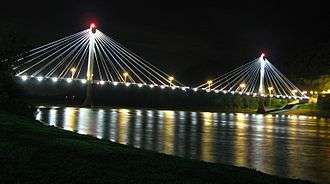 General U.S. Grant Bridge |
May 31, 2001 (#01000560) |
Ohio River-Chillicothe and 2nd St. 38°43′29″N 82°59′53″W |
South Portsmouth | Extends into Scioto County, Ohio. Demolished in 2001. |
| 4 | Greenup Masonic Lodge | 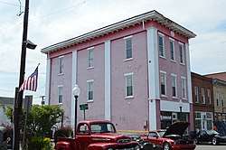 Greenup Masonic Lodge |
January 27, 1988 (#87002447) |
314 Main St. 38°34′40″N 82°50′12″W |
Greenup | |
| 5 | Kouns-Hoffman House | 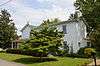 Kouns-Hoffman House |
January 27, 1988 (#87002445) |
208 Jefferson St. 38°34′37″N 82°50′00″W |
Greenup | |
| 6 | KY 2541 Bridge | 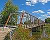 KY 2541 Bridge |
January 27, 1988 (#87002446) |
Main St. over the Little Sandy River 38°34′50″N 82°50′25″W |
Greenup | |
| 7 | Lower Shawneetown | 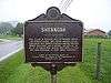 Lower Shawneetown |
April 28, 1983 (#83002784) |
Northwest of Kentucky Route 8[5] 38°42′54″N 83°01′42″W |
South Portsmouth | |
| 8 | Lower Shawneetown Archeological District | 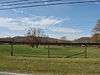 Lower Shawneetown Archeological District |
November 29, 1985 (#85003334) |
Scattered around South Portsmouth[6] 38°42′58″N 83°01′21″W |
South Portsmouth | Includes Lower Shawneetown and Group A of the Portsmouth Earthworks,[7] and extends into Lewis County |
| 9 | McConnell House, Law Office, and Slave Quarters | 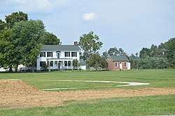 McConnell House, Law Office, and Slave Quarters |
July 30, 1975 (#75000764) |
West of Wurtland on U.S. Route 23 38°33′07″N 82°47′19″W |
Wurtland | |
| 10 | McKee House | 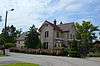 McKee House |
January 27, 1988 (#87002439) |
1023 Riverside Dr. 38°34′28″N 82°49′47″W |
Greenup | |
| 11 | Methodist Episcopal Church South | 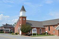 Methodist Episcopal Church South |
January 27, 1988 (#87002444) |
Main St. 38°34′36″N 82°50′05″W |
Greenup | |
| 12 | Oldtown Covered Bridge | 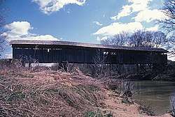 Oldtown Covered Bridge |
March 26, 1976 (#76000893) |
South of Oldtown off Kentucky Route 1 38°25′53″N 82°53′42″W |
Oldtown | |
| 13 | Portsmouth Earthworks, Group A |  Portsmouth Earthworks, Group A |
December 4, 1980 (#80001534) |
Between County Route 8 and the Ohio River, west of South Portsmouth[8] 38°43′18″N 83°01′23″W |
South Portsmouth | |
| 14 | Russell Railroad YMCA | 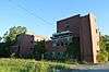 Russell Railroad YMCA |
May 2, 2001 (#01000452) |
451 Verhon St. 38°32′02″N 82°41′52″W |
Russell | |
| 15 | South Greenup District | 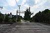 South Greenup District |
January 27, 1988 (#87002443) |
Roughly bounded by the C&O railroad line, Laurel St., Seaton Ave., and Washington St. 38°34′37″N 82°50′19″W |
Greenup | |
| 16 | Jesse Stuart House | June 1, 1982 (#82002700) |
Stuarts Lane off W. Hollow Rd. 38°33′02″N 82°50′13″W |
Greenup | ||
| 17 | Warnock House | 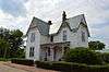 Warnock House |
January 27, 1988 (#87002442) |
404 Harrison 38°34′38″N 82°50′14″W |
Greenup | |
| 18 | West Main Street District | 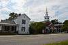 West Main Street District |
January 27, 1988 (#87002441) |
W. Main St. 38°34′44″N 82°50′18″W |
Greenup | |
| 19 | Worthington House | 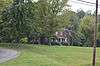 Worthington House |
January 27, 1988 (#87002438) |
U.S. Route 23 at Academy Rd. 38°34′06″N 82°49′56″W |
Greenup | |
| 20 | Wurtland Union Church | 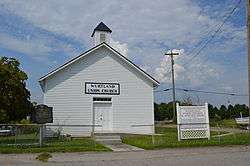 Wurtland Union Church |
December 4, 2008 (#08001119) |
325 Wurtland Ave. 38°33′02″N 82°46′52″W |
Wurtland |
See also
| Wikimedia Commons has media related to National Register of Historic Places in Greenup County, Kentucky. |
References
- The latitude and longitude information provided in this table was derived originally from the National Register Information System, which has been found to be fairly accurate for about 99% of listings. Some locations in this table may have been corrected to current GPS standards.
- "National Register of Historic Places: Weekly List Actions". National Park Service, United States Department of the Interior. Retrieved on June 19, 2020.
- Numbers represent an ordering by significant words. Various colorings, defined here, differentiate National Historic Landmarks and historic districts from other NRHP buildings, structures, sites or objects.
- The eight-digit number below each date is the number assigned to each location in the National Register Information System database, which can be viewed by clicking the number.
- Location derived from this historical marker; the NRIS lists the site as "Address Restricted"
- Location derived from those of other Portsmouth sites included in the district; NRIS mentions them but lists this site as "Address Restricted".
- "National Register Information System". National Register of Historic Places. National Park Service. June 30, 2007.
- Location derived from this map; the NRIS lists the site as "Address Restricted"
| Topics | |
|---|---|
| Lists by state |
|
| Lists by insular areas | |
| Lists by associated state | |
| Other areas | |
| Related | |
| |
Municipalities and communities of Greenup County, Kentucky, United States | ||
|---|---|---|
| Cities | | |
| Unincorporated communities | ||
This article is issued from Wikipedia. The text is licensed under Creative Commons - Attribution - Sharealike. Additional terms may apply for the media files.