National Register of Historic Places listings in Bullitt County, Kentucky
This is a list of the National Register of Historic Places listings in Bullitt County, Kentucky.
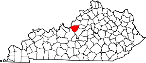
Location of Bullitt County in Kentucky
It is intended to be a complete list of the properties and districts on the National Register of Historic Places in Bullitt County, Kentucky, United States. The locations of National Register properties and districts for which the latitude and longitude coordinates are included below, may be seen in an online map.[1]
There are 10 properties and districts listed on the National Register in the county.
- This National Park Service list is complete through NPS recent listings posted June 19, 2020.[2]
Current listings
| [3] | Name on the Register | Image | Date listed[4] | Location | City or town | Description |
|---|---|---|---|---|---|---|
| 1 | Ashworth Rock Shelters Site | September 11, 1975 (#75000739) |
At the foot of McDonald's Knob, along Floyds Fork[5] 38°00′45″N 85°41′45″W |
Shepherdsville | ||
| 2 | Bank of the Commonwealth | 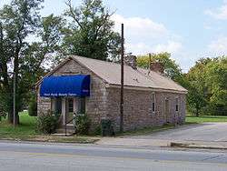 Bank of the Commonwealth |
January 8, 1987 (#87000173) |
Buckman St. 37°59′13″N 85°43′02″W |
Shepherdsville | |
| 3 | Henry J. Barnes House | 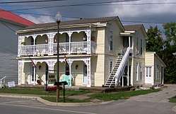 Henry J. Barnes House |
March 1, 1993 (#93000049) |
144 N. Bardstown Rd. 38°02′55″N 85°32′32″W |
Mount Washington | |
| 4 | T. Jeremiah Beam House | October 15, 1987 (#87001854) |
Big Level Rd. 37°55′51″N 85°39′12″W |
Clermont | ||
| 5 | Solomon Neill Brooks House | April 10, 1980 (#80001488) |
4893 North Preston Highway, Shepherdsville (N of Shepherdsville) at John Harper (KY 1526) and Preston Highways (KY 61), south of and adjacent to Schoppenhorst Underwood-Brooks funeral home 38°03′09″N 85°40′48″W |
Shepherdsville | ||
| 6 | Henry Crist House | January 8, 1987 (#87000215) |
Maraman Ln. off Kentucky Route 1604 37°57′22″N 85°34′09″W |
Brownington | ||
| 7 | Lebanon Junction Historic District | December 4, 2003 (#03001224) |
Roughly bounded by Maple St., Kentucky Route 61, Knoxville Ave., and Harrel and Masden Sts. 37°49′55″N 85°43′53″W |
Lebanon Junction | ||
| 8 | James M. Lloyd House | 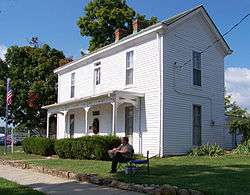 James M. Lloyd House |
February 11, 1993 (#93000048) |
Northeastern corner of the junction of U.S. Route 31E and East St. 38°02′51″N 85°32′25″W |
Mount Washington | |
| 9 | Louisville to Bardstown Turnpike Milestones and Roadbed | July 12, 2019 (#100004215) |
Along and near US 31E from Louisville to Bardstown 38°03′10″N 85°32′14″W |
Louisville | ||
| 10 | Zack Stansbury House | 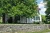 Zack Stansbury House |
February 11, 1993 (#93000047) |
1430 Bardstown Rd. 38°01′59″N 85°31′43″W |
Mount Washington |
See also
| Wikimedia Commons has media related to National Register of Historic Places in Bullitt County, Kentucky. |
References
- The latitude and longitude information provided in this table was derived originally from the National Register Information System, which has been found to be fairly accurate for about 99% of listings. Some locations in this table may have been corrected to current GPS standards.
- "National Register of Historic Places: Weekly List Actions". National Park Service, United States Department of the Interior. Retrieved on June 19, 2020.
- Numbers represent an ordering by significant words. Various colorings, defined here, differentiate National Historic Landmarks and historic districts from other NRHP buildings, structures, sites or objects.
- The eight-digit number below each date is the number assigned to each location in the National Register Information System database, which can be viewed by clicking the number.
- Location derived from DiBlasi, Philip James. A New Assessment of the Archaeological Significance of the Ashworth Site (15Bu236). Diss. U of Louisville: 1981, 7. The NRIS lists the site as "Address Restricted".
| Topics | |
|---|---|
| Lists by state |
|
| Lists by insular areas | |
| Lists by associated state | |
| Other areas | |
| Related | |
| |
Municipalities and communities of Bullitt County, Kentucky, United States | ||
|---|---|---|
| Cities | Location of Bullitt County, Kentucky | |
| CDP | ||
| Unincorporated communities | ||
This article is issued from Wikipedia. The text is licensed under Creative Commons - Attribution - Sharealike. Additional terms may apply for the media files.