National Register of Historic Places listings in Hopkins County, Kentucky
This is a list of the National Register of Historic Places listings in Hopkins County, Kentucky.
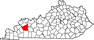
Location of Hopkins County in Kentucky
This is intended to be a complete list of the properties and districts on the National Register of Historic Places in Hopkins County, Kentucky, United States. The locations of National Register properties and districts for which the latitude and longitude coordinates are included below, may be seen in a map.[1]
There are 32 properties and districts listed on the National Register in the county. Another property was once listed but has been removed.
- This National Park Service list is complete through NPS recent listings posted June 19, 2020.[2]
Current listings
| [3] | Name on the Register | Image | Date listed[4] | Location | City or town | Description |
|---|---|---|---|---|---|---|
| 1 | Archeological Site 15 HK 46 and 47 | July 28, 1980 (#80001553) |
Address Restricted |
White Plains | ||
| 2 | Archeological Site 15 HK 79 | December 4, 1980 (#80001552) |
Address Restricted |
Nebo | ||
| 3 | Archeological Site 15 HK 8 | August 1, 1980 (#80001551) |
Address Restricted |
Hanson | ||
| 4 | Beulah Lodge | 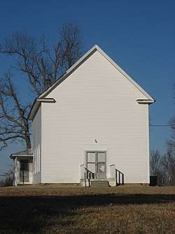 Beulah Lodge |
March 8, 1989 (#88002718) |
Kentucky Route 70, 0.5 miles west of its junction with Kentucky Route 109 37°16′17″N 87°41′24″W |
Dawson Springs | |
| 5 | John Cox House | December 13, 1988 (#88002715) |
Kentucky Route 502, 0.5 miles north of Nebo 37°23′37″N 87°38′20″W |
Nebo | ||
| 6 | Cranor School | March 8, 1989 (#88002721) |
Buttermilk Rd., 0.2 miles southeast of its junction with Hamby Rd. 37°07′46″N 87°35′09″W |
St. Charles | ||
| 7 | The Darby House | 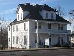 The Darby House |
August 15, 1997 (#97000871) |
301 W. Arcadia Ave. 37°10′00″N 87°41′37″W |
Dawson Springs | |
| 8 | Dawson Springs Historic District | 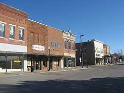 Dawson Springs Historic District |
December 13, 1988 (#88002710) |
100 block of S. Main St.; also roughly bounded by Keigan St., Water St., Arcadia Ave., Hunter St., and Sycamore St. 37°10′04″N 87°41′33″W |
Dawson Springs | Second group of streets represents a boundary increase |
| 9 | Bazle Edmiston House | 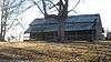 Bazle Edmiston House |
December 13, 1988 (#88002719) |
Kentucky Route 291, 0.2 miles west of its junction with Kentucky Route 109 37°19′30″N 87°43′07″W |
Nebo | |
| 10 | Dr. Thomas Gardiner House | 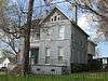 Dr. Thomas Gardiner House |
December 13, 1988 (#88002727) |
173 Sugg St. 37°19′39″N 87°30′08″W |
Madisonville | |
| 11 | Hanson Historic District | 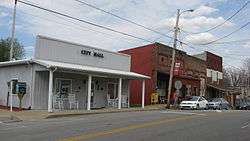 Hanson Historic District |
December 13, 1988 (#88002711) |
Roughly Main St. from U.S. Route 41 to E. Railroad St. 37°25′02″N 87°28′54″W |
Hanson | |
| 12 | John Harvey House | 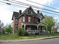 John Harvey House |
December 13, 1988 (#88002731) |
175 N. Seminary St. 37°19′54″N 87°30′07″W |
Madisonville | Designed by architect George Franklin Barber |
| 13 | L.D. Hockersmith House |  L.D. Hockersmith House |
December 13, 1988 (#88002729) |
218 S. Scott St. 37°19′29″N 87°29′44″W |
Madisonville | |
| 14 | Hotel Earlington | 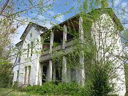 Hotel Earlington |
December 13, 1988 (#88002725) |
118 E. Main St. 37°16′28″N 87°30′41″W |
Earlington | |
| 15 | Beckley Jackson House | March 23, 1989 (#88002733) |
Kentucky Route 1069, 0.2 miles south of its junction with Jones Rd. 37°26′40″N 87°31′50″W |
Hanson | ||
| 16 | Gabriel Jennings House | 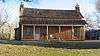 Gabriel Jennings House |
December 13, 1988 (#88002720) |
Kentucky Route 70, 1 mile east of its junction with Kentucky Route 291 37°16′17″N 87°46′02″W |
Dawson Springs | |
| 17 | W.W. Kington House |  W.W. Kington House |
December 13, 1988 (#88002724) |
109 Crooked St. 37°14′24″N 87°28′22″W |
Mortons Gap | |
| 18 | Chittenden P. Lyon, Jr. House | 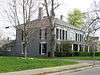 Chittenden P. Lyon, Jr. House |
October 18, 1976 (#76000898) |
304 Union St. 37°19′26″N 87°29′53″W |
Madisonville | |
| 19 | Madisonville Armory | 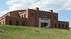 Madisonville Armory |
September 6, 2002 (#02000927) |
670 Park Ave. 37°18′59″N 87°29′19″W |
Madisonville | |
| 20 | Madisonville Commercial Historic District | 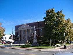 Madisonville Commercial Historic District |
December 13, 1988 (#88002712) |
Center and Main Sts. 37°19′40″N 87°29′55″W |
Madisonville | |
| 21 | Madisonville Public Library | 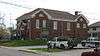 Madisonville Public Library |
December 13, 1988 (#88002728) |
107 S. Union St. 37°19′36″N 87°29′54″W |
Madisonville | |
| 22 | Madisonville Tuberculosis Hospital | August 4, 2016 (#16000496) |
625 Hospital Dr. 37°20′26″N 87°29′27″W |
Madisonville | ||
| 23 | Frederick Miller House | December 13, 1988 (#88002723) |
U.S. Route 62, 2.1 miles west of White Plains 37°11′32″N 87°25′14″W |
White Plains | ||
| 24 | Munn's School | August 30, 1983 (#83002796) |
Princeton Rd. 37°18′54″N 87°31′48″W |
Madisonville | ||
| 25 | North Main Street Historic District | 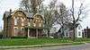 North Main Street Historic District |
December 13, 1988 (#88002713) |
Roughly the 200 and 300 blocks of N. Main St. 37°19′57″N 87°29′51″W |
Madisonville | |
| 26 | Oakmoor | 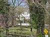 Oakmoor |
December 13, 1988 (#88002726) |
E. Main St. 37°16′37″N 87°30′30″W |
Earlington | |
| 27 | Bradford Porter House | December 13, 1988 (#88002714) |
U.S. Route 41A, 1 mile west of its junction with Kentucky Route 630 37°22′40″N 87°35′57″W |
Nebo | ||
| 28 | Turner Ruby House | 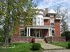 Turner Ruby House |
December 13, 1988 (#88002730) |
264 S. Union St. 37°19′27″N 87°29′53″W |
Madisonville | |
| 29 | Richard Salmon House | December 13, 1988 (#88002722) |
Kentucky Route 112 37°11′52″N 87°36′34″W |
Dawson Springs | ||
| 30 | James E. Slaton House | December 13, 1988 (#88002717) |
County Highway 1221 37°17′31″N 87°25′20″W |
Madisonville | ||
| 31 | US Post Office-Madisonville |  US Post Office-Madisonville |
January 3, 1989 (#88003196) |
56 N. Main St. 37°19′46″N 87°29′54″W |
Madisonville | |
| 32 | Zion Brick Missionary Church | December 13, 1988 (#88002716) |
Crossroad Chapel Rd., 0.3 miles north of its junction with Kentucky Route 138 37°29′56″N 87°28′46″W |
Hanson |
Former listing
| [3] | Name on the Register | Image | Date listed | Date removed | Location | City or town | Summary |
|---|---|---|---|---|---|---|---|
| 1 | Hamby Well Building | April 19, 1972 (#72000534) | February 3, 1988 | 120 S. Main St. |
Dawson Springs |
See also
| Wikimedia Commons has media related to National Register of Historic Places in Hopkins County, Kentucky. |
References
- The latitude and longitude information provided in this table was derived originally from the National Register Information System, which has been found to be fairly accurate for about 99% of listings. Some locations in this table may have been corrected to current GPS standards.
- "National Register of Historic Places: Weekly List Actions". National Park Service, United States Department of the Interior. Retrieved on June 19, 2020.
- Numbers represent an ordering by significant words. Various colorings, defined here, differentiate National Historic Landmarks and historic districts from other NRHP buildings, structures, sites or objects.
- The eight-digit number below each date is the number assigned to each location in the National Register Information System database, which can be viewed by clicking the number.
| Topics | |
|---|---|
| Lists by state |
|
| Lists by insular areas | |
| Lists by associated state | |
| Other areas | |
| Related | |
| |
Municipalities and communities of Hopkins County, Kentucky, United States | ||
|---|---|---|
| Cities | Location of Hopkins County, Kentucky | |
| CDP | ||
| Other unincorporated communities | ||
| Footnotes | ‡This populated place also has portions in an adjacent county or counties | |
This article is issued from Wikipedia. The text is licensed under Creative Commons - Attribution - Sharealike. Additional terms may apply for the media files.