National Register of Historic Places listings in Mason County, Kentucky
This is a list of the National Register of Historic Places listings in Mason County, Kentucky.
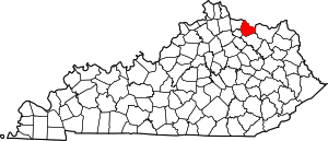
Location of Mason County in Kentucky
This is intended to be a complete list of the properties and districts on the National Register of Historic Places in Mason County, Kentucky, United States. The locations of National Register properties and districts for which the latitude and longitude coordinates are included below, may be seen in a map.[1]
There are 41 properties and districts listed on the National Register in the county.
- This National Park Service list is complete through NPS recent listings posted June 19, 2020.[2]
Current listings
| [3] | Name on the Register | Image | Date listed[4] | Location | City or town | Description |
|---|---|---|---|---|---|---|
| 1 | Armstrong Row |  Armstrong Row |
March 1, 1984 (#84001818) |
207-227 W. 2nd St. 38°38′59″N 83°46′08″W |
Maysville | |
| 2 | Bracken Baptist Church |  Bracken Baptist Church |
April 28, 1983 (#83002821) |
County Road 1235 38°42′22″N 83°55′08″W |
Minerva | |
| 3 | Courthouse Square and Mechanics' Row Historic District |  Courthouse Square and Mechanics' Row Historic District |
May 12, 1975 (#75000803) |
W. 3rd St. between Market and Sutton Sts. 38°38′50″N 83°45′59″W |
Maysville | |
| 4 | Cox-Hord House |  Cox-Hord House |
July 14, 1978 (#78001382) |
128 E. 3rd St. 38°38′42″N 83°45′44″W |
Maysville | |
| 5 | The Cox Building |  The Cox Building |
August 18, 2011 (#11000538) |
2-8 E. 3rd St. 38°38′48″N 83°45′54″W |
Maysville | |
| 6 | Richard Durrett House | March 5, 2018 (#100002158) |
804 Clarks Run Rd. 38°37′37″N 83°49′30″W |
Maysville | ||
| 7 | Tom Forman House | January 8, 1987 (#87000170) |
Off U.S. Route 62 38°36′29″N 83°48′59″W |
Washington | ||
| 8 | Fox Farm | May 9, 1983 (#83002822) |
Western side of Lees Creek, halfway between Mays Lick and the Licking River[5] 38°32′45″N 83°50′09″W |
Mays Lick | ||
| 9 | GAR Monument | .jpg) GAR Monument |
March 5, 2018 (#100002159) |
Maysville-Mason County Cemetery, 1521 Forest Ave. 38°38′18″N 83°43′53″W |
Maysville | |
| 10 | Gillespie Site (15MS50) | December 21, 1985 (#85003180) |
Address Restricted |
Mays Lick | ||
| 11 | Helena United Methodist Church | February 3, 2010 (#09001311) |
6479 Helena Rd. 38°29′50″N 83°45′51″W |
Helena | ||
| 12 | Lee House |  Lee House |
December 20, 1977 (#77000634) |
Front and Sutton Sts. 38°38′56″N 83°45′59″W |
Maysville | |
| 13 | Lee's Creek Covered Bridge |  Lee's Creek Covered Bridge |
March 26, 1976 (#76000923) |
South of Dover on Tuckahoe Rd. off Kentucky Route 8 38°45′01″N 83°52′44″W |
Dover | |
| 14 | Mays Lick Consolidated School | 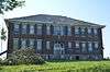 Mays Lick Consolidated School |
April 29, 1982 (#82002733) |
U.S. Route 68 and Kentucky Route 324 38°31′22″N 83°50′13″W |
Mays Lick | |
| 15 | May's Lick Negro School | 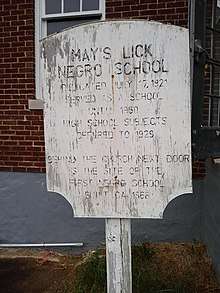 May's Lick Negro School |
March 5, 2018 (#100002160) |
5003 Raymond Rd. 38°31′04″N 83°50′20″W |
Mays Lick | |
| 16 | Maysville Downtown Historic District | 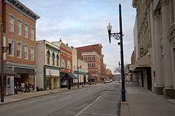 Maysville Downtown Historic District |
March 1, 1982 (#82002734) |
Roughly bounded by McDonald Parkway, Front, Wall, Limestone and 3rd Sts.; also W. 2nd, Sutton, Market, Limestone, W. 4th & E. 4th Sts. 38°38′50″N 83°45′55″W |
Maysville | Second set of addresses represent a boundary increase approved March 13, 2017 |
| 17 | Maysville-Aberdeen Bridge | 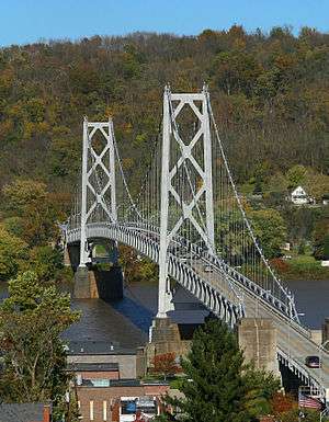 Maysville-Aberdeen Bridge |
June 30, 1983 (#83002823) |
Spans the Ohio River between Maysville and Aberdeen, Ohio 38°39′19″N 83°45′27″W |
Maysville | Extends into Brown County, Ohio |
| 18 | Milton Mills |  Milton Mills |
January 8, 1987 (#87000148) |
7191 Taylor Mill Rd. 38°34′27″N 83°44′04″W |
Orangeburg | |
| 19 | Ben Moran House |  Ben Moran House |
January 8, 1987 (#87000161) |
Intersection of Kentucky Routes 8 and 10 38°40′21″N 83°49′29″W |
Moranburg | |
| 20 | Newdigate-Reed House | 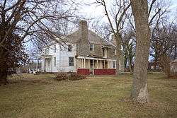 Newdigate-Reed House |
October 10, 1975 (#75000804) |
West of Maysville at the junction of Old U.S. Route 68 with U.S. Route 62 38°38′43″N 83°46′37″W |
Maysville | |
| 21 | Old Library Building |  Old Library Building |
August 30, 1974 (#74000895) |
221 Sutton St. 38°38′54″N 83°46′01″W |
Maysville | |
| 22 | Henry Perviance Peers House |  Henry Perviance Peers House |
December 21, 1998 (#98001486) |
325 W. 3rd St. 38°38′58″N 83°46′15″W |
Maysville | |
| 23 | Phillips' Folly | 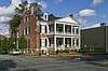 Phillips' Folly |
August 10, 1978 (#78001383) |
227 Sutton St. 38°38′51″N 83°46′03″W |
Maysville | |
| 24 | Poague House |  Poague House |
January 8, 1987 (#87000210) |
Parker Ln. 38°31′24″N 83°49′08″W |
Mays Lick | |
| 25 | Pogue House |  Pogue House |
November 25, 2005 (#05001322) |
716 W. 2nd St. 38°39′44″N 83°46′48″W |
Maysville | |
| 26 | Point Au View |  Point Au View |
January 4, 1985 (#85000015) |
721 Hillcrest Rd. 38°38′52″N 83°46′37″W |
Maysville | |
| 27 | Pyles Site (15MS28) | April 5, 1984 (#84001821) |
Address Restricted |
Mays Lick | ||
| 28 | John Brett Richeson House | 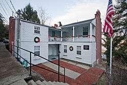 John Brett Richeson House |
July 22, 1994 (#94000733) |
331 W. 3rd St. 38°39′03″N 83°46′20″W |
Maysville | |
| 29 | Russell Theatre | 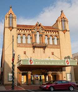 Russell Theatre |
March 31, 2006 (#06000216) |
9 E. 3rd St. 38°38′48″N 83°45′53″W |
Maysville | |
| 30 | Rust House | February 23, 1978 (#78001384) |
South of Maysville on Kentucky Route 11 38°32′24″N 83°45′10″W |
Maysville | ||
| 31 | Spring House at Flat Fork | October 6, 1987 (#87002051) |
Kentucky Route 161 38°29′48″N 83°49′43″W |
Flat Fork | ||
| 32 | Springhouse in Mays Lick |  Springhouse in Mays Lick |
October 6, 1987 (#87002052) |
Off Kentucky Route 324 38°31′04″N 83°50′11″W |
Mays Lick | |
| 33 | Sroufe House | February 12, 2016 (#16000010) |
2471 Mary Ingles Hwy. 38°44′56″N 83°51′55″W |
Dover | ||
| 34 | Stone Barn on Lee's Creek |  Stone Barn on Lee's Creek |
January 8, 1987 (#87000200) |
U.S. Route 68 38°31′56″N 83°49′46″W |
Mays Lick | |
| 35 | Valley Pike Covered Bridge | 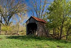 Valley Pike Covered Bridge |
March 26, 1976 (#76000924) |
West of Maysville off Kentucky Route 8 38°40′27″N 83°52′20″W |
Maysville | |
| 36 | Van Meter Site | December 5, 1985 (#85003040) |
Address Restricted |
Mays Lick | ||
| 37 | Washington Historic District |  Washington Historic District |
January 21, 1970 (#70000253) |
Roughly bounded by Hoppe St., Bartlett Lane, and city limits on the east and the west; also extending north and south along U.S. Routes 62 and 68 38°36′50″N 83°48′28″W |
Washington | Boundaries along U.S. Routes 62 and 68 represent a boundary increase |
| 38 | Washington Opera House | 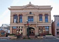 Washington Opera House |
June 11, 1975 (#75000805) |
116 W. 2nd St. 38°38′54″N 83°46′02″W |
Maysville | |
| 39 | West Second Street District | August 7, 2017 (#100001425) |
W. 2nd, Rosemary Clooney & Short Sts., Rosemary, Shultz & unnamed Alleys. 38°39′04″N 83°46′16″W |
Maysville | ||
| 40 | West Fourth Street District | 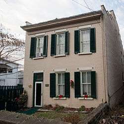 West Fourth Street District |
November 7, 1974 (#74000896) |
24, 29, 31, 32, 33 W. 4th St. 38°38′46″N 83°46′02″W |
Maysville | |
| 41 | Woodlawn | November 24, 1978 (#78001385) |
South of Maysville on Kentucky Route 11 38°35′23″N 83°45′58″W |
Maysville |
See also
| Wikimedia Commons has media related to National Register of Historic Places in Mason County, Kentucky. |
References
- The latitude and longitude information provided in this table was derived originally from the National Register Information System, which has been found to be fairly accurate for about 99% of listings. Some locations in this table may have been corrected to current GPS standards.
- "National Register of Historic Places: Weekly List Actions". National Park Service, United States Department of the Interior. Retrieved on June 19, 2020.
- Numbers represent an ordering by significant words. Various colorings, defined here, differentiate National Historic Landmarks and historic districts from other NRHP buildings, structures, sites or objects.
- The eight-digit number below each date is the number assigned to each location in the National Register Information System database, which can be viewed by clicking the number.
- Turnbow, Christopher A. "The Fox Farm Site". Fort Ancient Cultural Dynamics in the Middle Ohio Valley. A. Gwynn Henderson, ed. Madison: Prehistory, 1992. 51-68: 51, 53.
| Topics | |
|---|---|
| Lists by state |
|
| Lists by insular areas | |
| Lists by associated state | |
| Other areas | |
| Related | |
| |
Municipalities and communities of Mason County, Kentucky, United States | ||
|---|---|---|
| Cities | Location of Mason County, Kentucky | |
| CDP | ||
| Other unincorporated communities | ||
| Footnotes | ‡This populated place also has portions in an adjacent county or counties | |
This article is issued from Wikipedia. The text is licensed under Creative Commons - Attribution - Sharealike. Additional terms may apply for the media files.