National Register of Historic Places listings in Johnson County, Kentucky
This is a list of the National Register of Historic Places listings in Johnson County, Kentucky.
Location of Johnson County in Kentucky
This is intended to be a complete list of the properties and districts on the National Register of Historic Places in Johnson County, Kentucky, United States. The locations of National Register properties and districts for which the latitude and longitude coordinates are included below, may be seen in a map.[1]
There are 39 properties and districts listed on the National Register in the county. Another 2 properties were once listed but have been removed.
- This National Park Service list is complete through NPS recent listings posted June 19, 2020.[2]
Current listings
| [3] | Name on the Register | Image | Date listed[4] | Location | City or town | Description |
|---|---|---|---|---|---|---|
| 1 | Archer House |  Archer House |
January 26, 1989 (#88003162) |
170 Euclid St. 37°48′54″N 82°47′59″W |
Paintsville | |
| 2 | Blanton Archeological Site | July 30, 1975 (#75000782) |
Address Restricted |
Oil Springs | ||
| 3 | Jeff Bond House | January 26, 1989 (#88003174) |
Kentucky Route 172 37°55′31″N 82°57′22″W |
Redbush | ||
| 4 | Dameron Shelter Archeological Site | August 1, 1975 (#75000784) |
Address Restricted |
Paintsville | ||
| 5 | Daniel Davis House | October 9, 1974 (#74000886) |
Northwest of Paintsville on U.S. Route 460 37°49′21″N 82°50′05″W |
Paintsville | ||
| 6 | First Baptist Church | 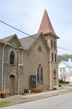 First Baptist Church |
January 26, 1989 (#88003165) |
College St. 37°49′00″N 82°48′23″W |
Paintsville | |
| 7 | First Methodist Church | .jpg) First Methodist Church |
January 26, 1989 (#88003155) |
Main and Church Sts. 37°48′50″N 82°48′31″W |
Paintsville | |
| 8 | First National Bank Building | .jpg) First National Bank Building |
January 26, 1989 (#88003154) |
Main and College Sts. 37°48′49″N 82°48′20″W |
Paintsville | |
| 9 | Flat Gap School | January 26, 1989 (#88003187) |
Kentucky Route 689 near the junction with Kentucky Route 1092 37°56′11″N 82°53′15″W |
Flat Gap | ||
| 10 | Foster Hardware |  Foster Hardware |
January 26, 1989 (#88003156) |
Main and Court Sts. 37°48′49″N 82°48′26″W |
Paintsville | |
| 11 | John J. and Ellen Lemaster House | January 26, 1989 (#88003177) |
0.6 miles northeast of Low Gap on Low Gap Fork 37°52′11″N 82°56′26″W |
Low Gap | ||
| 12 | Mayo Methodist Church | 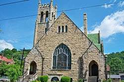 Mayo Methodist Church |
January 26, 1989 (#88003152) |
3rd St. 37°48′58″N 82°48′26″W |
Paintsville | |
| 13 | John C. C. Mayo Mansion and Office | 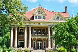 John C. C. Mayo Mansion and Office |
May 3, 1974 (#74000887) |
405 3rd St. 37°48′59″N 82°48′29″W |
Paintsville | |
| 14 | Thomas Mayo House |  Thomas Mayo House |
January 26, 1989 (#88003166) |
228 2nd St. 37°48′54″N 82°48′35″W |
Paintsville | |
| 15 | David McKenzie Log Cabin |  David McKenzie Log Cabin |
August 26, 1982 (#82002728) |
McKenzie Branch 37°52′56″N 82°54′44″W |
Volga | |
| 16 | Meade Memorial Gymnasium | 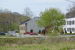 Meade Memorial Gymnasium |
January 26, 1989 (#88003170) |
Junction of Kentucky Routes 40 and 2040 37°50′11″N 82°43′19″W |
Williamsport | |
| 17 | Mine No. 5 Store | 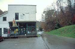 Mine No. 5 Store |
January 26, 1989 (#88003172) |
Kentucky Route 302 37°46′22″N 82°43′41″W |
Van Lear | |
| 18 | Ben Mollett Cabin | January 26, 1989 (#88003171) |
Off Kentucky Route 40 at Pigeon Roost Fork of Greasy Creek 37°48′09″N 82°42′19″W |
Williamsport | ||
| 19 | Lloyd Hamilton Mott House | January 26, 1989 (#88003175) |
Kentucky Route 172 37°56′26″N 82°57′06″W |
Redbush | ||
| 20 | Oil Springs High School Gymnasium | January 26, 1989 (#88003178) |
Kentucky Route 580 off Kentucky Route 40 37°48′40″N 82°56′37″W |
Oil Springs | ||
| 21 | Oil Springs Methodist Church | January 26, 1989 (#88003179) |
Junction of Kentucky Route 580 and Kentucky Route 40 37°48′37″N 82°56′35″W |
Oil Springs | ||
| 22 | Paintsville City Hall | 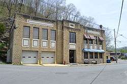 Paintsville City Hall |
January 26, 1989 (#88003158) |
Main St. and spur of Kentucky Route 40 37°48′55″N 82°48′09″W |
Paintsville | |
| 23 | Paintsville Country Club |  Paintsville Country Club |
January 26, 1989 (#88003168) |
Kentucky Route 1107 at Davis Branch 37°48′18″N 82°46′35″W |
Paintsville | |
| 24 | Paintsville High School | January 26, 1989 (#88003163) |
2nd St. 37°48′55″N 82°48′24″W |
Paintsville | Formerly on the site of the current elementary school. | |
| 25 | Paintsville Public Library |  Paintsville Public Library |
January 26, 1989 (#88003164) |
2nd St. 37°48′55″N 82°48′22″W |
Paintsville | |
| 26 | Patterson House |  Patterson House |
January 26, 1989 (#88003167) |
West and 2nd St. 37°48′53″N 82°48′40″W |
Paintsville | |
| 27 | H.B. Rice Insurance Building | 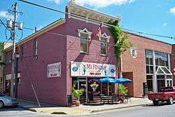 H.B. Rice Insurance Building |
January 26, 1989 (#88003157) |
Court and Main Sts. 37°48′50″N 82°48′25″W |
Paintsville | |
| 28 | Wiley Rice House | January 26, 1989 (#88003180) |
Kentucky Route 825 at Asa Creek 37°45′35″N 82°52′40″W |
Asa | ||
| 29 | Salyer House | January 26, 1989 (#88003181) |
Off Kentucky Route 825 at Asa Creek 37°46′11″N 82°55′04″W |
Asa | ||
| 30 | Addison Salyer House | January 26, 1989 (#88003169) |
Off Kentucky Route 825 at Middle Fork of Jenny's Creek 37°45′50″N 82°50′43″W |
Paintsville | ||
| 31 | Sparks Shelter Archeological Site | July 30, 1975 (#75000783) |
Address Restricted |
Oil Springs | ||
| 32 | Francis M. Stafford House |  Francis M. Stafford House |
October 29, 1975 (#75000785) |
102 Broadway 37°48′45″N 82°48′21″W |
Paintsville | |
| 33 | Stambaugh Church of Christ | January 26, 1989 (#88003182) |
Kentucky Route 1559 at Frog Ornery Branch 37°53′25″N 82°48′26″W |
Stambaugh | ||
| 34 | Stambaugh House | January 26, 1989 (#88003183) |
Kentucky Route 1559 at Van Hoose Branch 37°53′28″N 82°49′11″W |
Stambaugh | ||
| 35 | Judge Jim Turner House |  Judge Jim Turner House |
January 26, 1989 (#88003153) |
315 3rd St. 37°48′56″N 82°48′31″W |
Paintsville | |
| 36 | Webb House |  Webb House |
January 26, 1989 (#88003160) |
139 Main St. 37°48′52″N 82°48′08″W |
Paintsville | |
| 37 | Byrd and Leona Webb House |  Byrd and Leona Webb House |
January 26, 1989 (#88003159) |
137 Main St. 37°48′52″N 82°48′09″W |
Paintsville | |
| 38 | Tobe Wiley House |  Tobe Wiley House |
January 26, 1989 (#88003161) |
141 Euclid St. 37°48′52″N 82°48′07″W |
Paintsville | |
| 39 | Williams House | January 26, 1989 (#88003173) |
Kentucky Route 689/Elna Rd. 37°55′17″N 82°57′25″W |
Redbush |
Former listings
| [3] | Name on the Register | Image | Date listed | Date removed | Location | City or town | Summary |
|---|---|---|---|---|---|---|---|
| 1 | Thomas Akers House | January 26, 1989 (#88003151) | June 14, 1989 | 374 Fifth |
Paintsville | ||
| 2 | John Davis House | January 26, 1989 (#88003176) | June 14, 1989 | Off Davis Branch Rd. |
Oil Springs |
See also
| Wikimedia Commons has media related to National Register of Historic Places in Johnson County, Kentucky. |
References
- The latitude and longitude information provided in this table was derived originally from the National Register Information System, which has been found to be fairly accurate for about 99% of listings. Some locations in this table may have been corrected to current GPS standards.
- "National Register of Historic Places: Weekly List Actions". National Park Service, United States Department of the Interior. Retrieved on June 19, 2020.
- Numbers represent an ordering by significant words. Various colorings, defined here, differentiate National Historic Landmarks and historic districts from other NRHP buildings, structures, sites or objects.
- The eight-digit number below each date is the number assigned to each location in the National Register Information System database, which can be viewed by clicking the number.
| Topics | |
|---|---|
| Lists by state |
|
| Lists by insular areas | |
| Lists by associated state | |
| Other areas | |
| Related | |
| |
Municipalities and communities of Johnson County, Kentucky, United States | ||
|---|---|---|
| City | Location of Johnson County, Kentucky | |
| Unincorporated communities |
| |
This article is issued from Wikipedia. The text is licensed under Creative Commons - Attribution - Sharealike. Additional terms may apply for the media files.