National Register of Historic Places listings in Menifee County, Kentucky
This is a list of the National Register of Historic Places listings in Menifee County, Kentucky.

Location of Menifee County in Kentucky
It is intended to be a complete list of the properties on the National Register of Historic Places in Menifee County, Kentucky, United States. The locations of National Register properties for which the latitude and longitude coordinates are included below, may be seen in a map.[1]
There are 6 properties listed on the National Register in the county.
- This National Park Service list is complete through NPS recent listings posted June 19, 2020.[2]
Current listings
| [3] | Name on the Register | Image | Date listed[4] | Location | City or town | Description |
|---|---|---|---|---|---|---|
| 1 | Archeological Site 15MF355 | July 11, 1985 (#85001505) |
Address Restricted |
Frenchburg | ||
| 2 | Frenchburg School Campus | 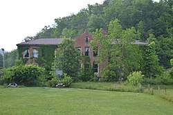 Frenchburg School Campus |
December 22, 1978 (#78001387) |
U.S. Route 460 37°57′07″N 83°37′46″W |
Frenchburg | |
| 3 | Red River Gorge District | September 12, 2003 (#03000919) |
Includes the confluence of Gladie Creek with the Red River[5] 37°50′12″N 83°36′44″W |
Daniel Boone National Forest | A large area in the national forest with extensive archaeological resources, including numerous rock shelters. | |
| 4 | Skidmore Petroglyphs | January 2, 1992 (#91001887) |
Address Restricted |
Fagan | ||
| 5 | Spratt's Petroglyphs (15MF353) | September 8, 1989 (#89001197) |
Address Restricted |
Frenchburg | ||
| 6 | W.S. Webb Memorial Rock Shelter | January 9, 1979 (#79001022) |
Address Restricted |
Frenchburg |
See also
| Wikimedia Commons has media related to National Register of Historic Places in Menifee County, Kentucky. |
References
- The latitude and longitude information provided in this table was derived originally from the National Register Information System, which has been found to be fairly accurate for about 99% of listings. Some locations in this table may have been corrected to current GPS standards.
- "National Register of Historic Places: Weekly List Actions". National Park Service, United States Department of the Interior. Retrieved on June 19, 2020.
- Numbers represent an ordering by significant words. Various colorings, defined here, differentiate National Historic Landmarks and historic districts from other NRHP buildings, structures, sites or objects.
- The eight-digit number below each date is the number assigned to each location in the National Register Information System database, which can be viewed by clicking the number.
- Wyss, James D., and Sandra K. Wyss. An Archaeological Assessment of Portions of the Red River Gorge, Daniel Boone National Forest, Kentucky. Lexington: Ohio Valley Archaeological Research Associates, 1977, 233.
Municipalities and communities of Menifee County, Kentucky, United States | ||
|---|---|---|
| City | Location of Menifee County, Kentucky | |
| Unincorporated communities | ||
| Topics | |
|---|---|
| Lists by state |
|
| Lists by insular areas | |
| Lists by associated state | |
| Other areas | |
| Related | |
| |
This article is issued from Wikipedia. The text is licensed under Creative Commons - Attribution - Sharealike. Additional terms may apply for the media files.