National Register of Historic Places listings in Anderson County, Kentucky
This is a list of the National Register of Historic Places listings in Anderson County, Kentucky.

Location of Anderson County in Kentucky
This is intended to be a complete list of the properties and districts on the National Register of Historic Places in Anderson County, Kentucky, United States. The locations of National Register properties and districts for which the latitude and longitude coordinates are included below, may be seen in a map.[1]
There are 12 properties and districts listed on the National Register in the county.
- This National Park Service list is complete through NPS recent listings posted June 19, 2020.[2]
Current listings
| [3] | Name on the Register | Image | Date listed[4] | Location | City or town | Description |
|---|---|---|---|---|---|---|
| 1 | Confederate Monument in Lawrenceburg | 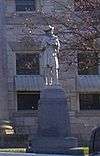 Confederate Monument in Lawrenceburg |
July 17, 1997 (#97000716) |
Courthouse Lawn, 0.5 miles south of U.S. Route 127 and Kentucky Route 44 38°02′06″N 84°53′44″W |
Lawrenceburg | |
| 2 | R.H. Crossfield House | 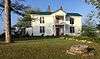 R.H. Crossfield House |
June 11, 1975 (#75000730) |
Southwest of Lawrenceburg off Anderson City Rd. 37°59′06″N 84°58′57″W |
Lawrenceburg | |
| 3 | Dowling House |  Dowling House |
July 10, 1979 (#79000957) |
321 S. Main St. 38°01′59″N 84°53′40″W |
Lawrenceburg | |
| 4 | Thomas H. Hanks House | May 14, 1980 (#80001478) |
516 E. Woodford St. 38°02′21″N 84°53′11″W |
Lawrenceburg | ||
| 5 | Kavanaugh Academy | 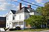 Kavanaugh Academy |
September 19, 1973 (#73000781) |
241 E. Woodford St. 38°02′19″N 84°53′32″W |
Lawrenceburg | |
| 6 | Lawrenceburg Commercial Historic District | 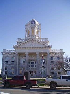 Lawrenceburg Commercial Historic District |
August 5, 1994 (#94000837) |
Roughly Main St. from North Alley to Court St. and Court from Main to the Southern Railway tracks 38°02′11″N 84°53′44″W |
Lawrenceburg | |
| 7 | Lexington Extension of the Louisville Southern Railroad |  Lexington Extension of the Louisville Southern Railroad |
August 4, 2004 (#04000789) |
Eastern Lawrenceburg to Milner 38°02′08″N 84°50′00″W |
Lawrenceburg | Extends into Woodford County |
| 8 | McBrayer-Clark House |  McBrayer-Clark House |
September 19, 1973 (#73000782) |
North of Lawrenceburg on Kentucky Route 326 38°04′06″N 84°54′19″W |
Lawrenceburg | |
| 9 | Rev. William Dudley Moore House | 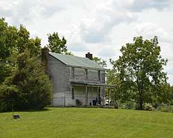 Rev. William Dudley Moore House |
February 21, 1979 (#79000958) |
4 miles (6.4 km) south of Lawrenceburg 37°59′00″N 84°52′31″W |
Lawrenceburg | |
| 10 | Old Prentice Distillery | 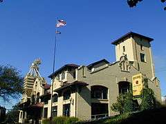 Old Prentice Distillery |
March 19, 1987 (#87000478) |
Kentucky Route 513 37°58′23″N 84°53′54″W |
Lawrenceburg | |
| 11 | Old Wash Place | June 11, 1975 (#75000731) |
9 miles west of Lawrenceburg at the junction of U.S. Route 62 and Kentucky Route 53 37°57′36″N 85°01′28″W |
Lawrenceburg | ||
| 12 | T.B. Ripy House | 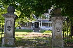 T.B. Ripy House |
February 20, 1980 (#80001479) |
320 S. Main St. 38°01′58″N 84°53′44″W |
Lawrenceburg |
See also
| Wikimedia Commons has media related to National Register of Historic Places in Anderson County, Kentucky. |
References
- The latitude and longitude information provided in this table was derived originally from the National Register Information System, which has been found to be fairly accurate for about 99% of listings. Some locations in this table may have been corrected to current GPS standards.
- "National Register of Historic Places: Weekly List Actions". National Park Service, United States Department of the Interior. Retrieved on June 19, 2020.
- Numbers represent an ordering by significant words. Various colorings, defined here, differentiate National Historic Landmarks and historic districts from other NRHP buildings, structures, sites or objects.
- The eight-digit number below each date is the number assigned to each location in the National Register Information System database, which can be viewed by clicking the number.
| Topics | |
|---|---|
| Lists by state |
|
| Lists by insular areas | |
| Lists by associated state | |
| Other areas | |
| Related | |
| |
Municipalities and communities of Anderson County, Kentucky, United States | ||
|---|---|---|
| City | Location of Anderson County, Kentucky | |
| Unincorporated communities | ||
| Ghost town | ||
This article is issued from Wikipedia. The text is licensed under Creative Commons - Attribution - Sharealike. Additional terms may apply for the media files.