National Register of Historic Places listings in Powell County, Kentucky
This is a list of the National Register of Historic Places listings in Powell County, Kentucky.
Location of Powell County in Kentucky
This is intended to be a complete list of the properties and districts on the National Register of Historic Places in Powell County, Kentucky, United States. The locations of National Register properties and districts for which the latitude and longitude coordinates are included below, may be seen in a map.[1]
There are 16 properties and districts listed on the National Register in the county.
- This National Park Service list is complete through NPS recent listings posted June 19, 2020.[2]
Current listings
| [3] | Name on the Register | Image | Date listed[4] | Location | City or town | Description |
|---|---|---|---|---|---|---|
| 1 | Amburgy Hollow Petroglyphs | January 2, 1992 (#91001885) |
Off Kentucky Route 613 atop the northern side of Amburgy Hollow[5]:119 37°50′53″N 83°41′42″W |
Nada | ||
| 2 | Anderson Site | August 14, 1975 (#75000820) |
Address Restricted |
Stanton | ||
| 3 | Branham Ridge Petroglyphs (15PO158) | January 2, 1992 (#89001198) |
Address Restricted |
Vaughn's Mill | ||
| 4 | Clay City National Bank Building | 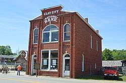 Clay City National Bank Building |
July 13, 1976 (#76000940) |
6th Ave. 37°51′38″N 83°55′16″W |
Clay City | |
| 5 | Haystack Rock Shelter | August 14, 1975 (#75000821) |
Address Restricted |
Stanton | ||
| 6 | High Rock Petroglyphs (15PO25) | September 8, 1989 (#89001201) |
Between Cat Creek Rd. and the High Rock Lookout Tower[5]:114 37°47′16″N 83°46′42″W |
Nada | ||
| 7 | Martin Fork Petroglyphs | January 2, 1992 (#91001886) |
Off Tunnel Ridge Rd. along the Daniel Boone Trail[5]:119 37°48′25″N 83°39′32″W |
Nada | ||
| 8 | Martin Site | August 14, 1975 (#75000822) |
Address Restricted |
Stanton | ||
| 9 | McKinney Bluff Petroglyphs (15PO107) | September 8, 1989 (#89001199) |
Address Restricted |
Nada | ||
| 10 | Nada Tunnel 1 Petroglyphs | April 20, 1992 (#92000342) |
Address Restricted |
Nada | ||
| 11 | Nada Tunnel 2 | January 2, 1992 (#91001883) |
Address Restricted |
Nada | ||
| 12 | Raised Spirits Rockshelter | March 15, 2005 (#05000144) |
Address Restricted |
Slade | ||
| 13 | Seldon Skidmore Site | August 14, 1975 (#75000823) |
Address Restricted |
Stanton | ||
| 14 | Shepherd Site | August 13, 1975 (#75000819) |
Address Restricted |
Slade | ||
| 15 | State Rock Petroglyph Site (15PO106) | September 8, 1989 (#89001200) |
Address Restricted |
Furnace | ||
| 16 | White's Rockshelter Petroglyphs | January 2, 1992 (#91001884) |
Address Restricted |
Knowlton |
See also
| Wikimedia Commons has media related to National Register of Historic Places in Powell County, Kentucky. |
References
- The latitude and longitude information provided in this table was derived originally from the National Register Information System, which has been found to be fairly accurate for about 99% of listings. Some locations in this table may have been corrected to current GPS standards.
- "National Register of Historic Places: Weekly List Actions". National Park Service, United States Department of the Interior. Retrieved on June 19, 2020.
- Numbers represent an ordering by significant words. Various colorings, defined here, differentiate National Historic Landmarks and historic districts from other NRHP buildings, structures, sites or objects.
- The eight-digit number below each date is the number assigned to each location in the National Register Information System database, which can be viewed by clicking the number.
- Coy, Fred E., Jr., and Thomas C. Fuller. "Petroglyphs of Powell County, Kentucky". Central States Archaeological Journal 18.3 (1971): 112-122.
| Topics | |
|---|---|
| Lists by state |
|
| Lists by insular areas | |
| Lists by associated state | |
| Other areas | |
| Related | |
| |
Municipalities and communities of Powell County, Kentucky, United States | ||
|---|---|---|
| Cities | Location of Powell County, Kentucky | |
| Unincorporated communities | ||
This article is issued from Wikipedia. The text is licensed under Creative Commons - Attribution - Sharealike. Additional terms may apply for the media files.