National Register of Historic Places listings in Rowan County, Kentucky
This is a list of the National Register of Historic Places listings in Rowan County, Kentucky.
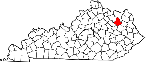
Location of Rowan County in Kentucky
This is intended to be a complete list of the properties and districts on the National Register of Historic Places in Rowan County, Kentucky, United States. The locations of National Register properties and districts for which the latitude and longitude coordinates are included below, may be seen in a map.[1]
There are 13 properties and districts listed on the National Register in the county.
- This National Park Service list is complete through NPS recent listings posted June 19, 2020.[2]
Current listings
| [3] | Name on the Register | Image | Date listed[4] | Location | City or town | Description |
|---|---|---|---|---|---|---|
| 1 | Brushy Voting House No. 6 | April 9, 1998 (#98000340) |
Junction of Kentucky Route 32 and Spruce St. 38°13′55″N 83°29′57″W |
Morehead | ||
| 2 | Cranston Voting House No. 12 | April 9, 1998 (#98000344) |
Junction of Clear Fork Rd. and Kentucky Route 377 38°15′49″N 83°26′10″W |
Morehead | ||
| 3 | Farmers Voting House No. 2 | April 9, 1998 (#98000337) |
Kentucky Route 801, 0.1 miles south of Farmers 38°08′43″N 83°32′43″W |
Morehead | ||
| 4 | Haldeman Voting House No. 8 | 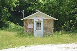 Haldeman Voting House No. 8 |
April 9, 1998 (#98000342) |
Kentucky Route 174 38°14′37″N 83°19′24″W |
Morehead | |
| 5 | Hayes Voting House No. 16 |  Hayes Voting House No. 16 |
April 9, 1998 (#98000346) |
Little Perry Rd., near the junction with Kentucky Route 60 38°14′30″N 83°21′03″W |
Morehead | |
| 6 | Hogtown Voting House No. 4 | April 9, 1998 (#98000338) |
Williamstown Rd. 38°10′50″N 83°16′28″W |
Morehead | ||
| 7 | Morehead Chesapeake and Ohio Railway Freight Depot | 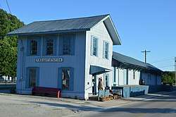 Morehead Chesapeake and Ohio Railway Freight Depot |
February 12, 2016 (#16000013) |
130 E. 1st St. 38°10′53″N 83°26′00″W |
Morehead | |
| 8 | Morehead State University |  Morehead State University |
November 25, 1994 (#94001381) |
Bounded by University Boulevard, Battson Ave. and Ward Oates Dr. 38°11′12″N 83°26′04″W |
Morehead | |
| 9 | Morehead Voting House No. 7 | 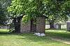 Morehead Voting House No. 7 |
April 9, 1998 (#98000341) |
Clearfield St. 38°10′19″N 83°26′14″W |
Morehead | |
| 10 | Morehead Voting House No. 10 | 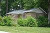 Morehead Voting House No. 10 |
April 9, 1998 (#98000343) |
Junction of Knapp and W. 2nd St. 38°10′50″N 83°26′21″W |
Morehead | |
| 11 | Pine Grove Voting House No. 5 | April 9, 1998 (#98000339) |
Rock Fork Rd., 0.5 miles north of Kentucky Route 377 38°17′13″N 83°24′49″W |
Morehead | ||
| 12 | Plank Voting House No. 15 | April 9, 1998 (#98000345) |
815 Plank Chapel Rd. 38°19′28″N 83°23′43″W |
Morehead | ||
| 13 | Rowan County Courthouse | 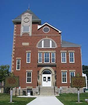 Rowan County Courthouse |
July 21, 1983 (#83002862) |
Main St. 38°11′03″N 83°26′00″W |
Morehead | Boundary increase approved March 13, 2017 Now Rowan County Arts Center |
See also
| Wikimedia Commons has media related to National Register of Historic Places in Rowan County, Kentucky. |
References
- The latitude and longitude information provided in this table was derived originally from the National Register Information System, which has been found to be fairly accurate for about 99% of listings. Some locations in this table may have been corrected to current GPS standards.
- "National Register of Historic Places: Weekly List Actions". National Park Service, United States Department of the Interior. Retrieved on June 19, 2020.
- Numbers represent an ordering by significant words. Various colorings, defined here, differentiate National Historic Landmarks and historic districts from other NRHP buildings, structures, sites or objects.
- The eight-digit number below each date is the number assigned to each location in the National Register Information System database, which can be viewed by clicking the number.
| Topics | |
|---|---|
| Lists by state |
|
| Lists by insular areas | |
| Lists by associated state | |
| Other areas | |
| Related | |
| |
Municipalities and communities of Rowan County, Kentucky, United States | ||
|---|---|---|
| Cities | Location of Rowan County, Kentucky | |
| CDP | ||
| Other unincorporated communities | ||
This article is issued from Wikipedia. The text is licensed under Creative Commons - Attribution - Sharealike. Additional terms may apply for the media files.