Dane County, Wisconsin
Dane County is a county in the U.S. state of Wisconsin. As of the 2010 census, the population was 488,075, making it the second-most populous county in Wisconsin. The 2019 estimate places the county's population at 546,695.[1] The county seat is Madison,[2] which is also the state capital.
Dane County | |
|---|---|
 The Dane County Courthouse, 2004 | |
 Seal | |
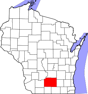 Location within the U.S. state of Wisconsin | |
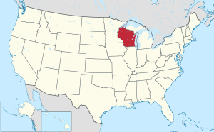 Wisconsin's location within the U.S. | |
| Coordinates: 43°04′N 89°25′W | |
| Country | |
| State | |
| Founded | 1839 |
| Named for | Nathan Dane |
| Seat | Madison |
| Largest city | Madison |
| Area | |
| • Total | 1,238 sq mi (3,210 km2) |
| • Land | 1,197 sq mi (3,100 km2) |
| • Water | 41 sq mi (110 km2) 3.3% |
| Population (2010) | |
| • Total | 488,075 |
| • Estimate (2019) | 546,695 |
| • Density | 390/sq mi (150/km2) |
| Time zone | UTC−6 (Central) |
| • Summer (DST) | UTC−5 (CDT) |
| Congressional district | 2nd |
| Website | www |
Dane County is the central county of the Madison, Wisconsin, Metropolitan Statistical Area, as well as the Madison-Janesville-Beloit Combined Statistical Area.
History
Dane County was formed in 1836 as a territorial county and organized in 1839.[3] It was named after Nathan Dane, a Massachusetts delegate to the Congress of the Confederation who helped carve Wisconsin out of the Northwest Territory.[4][5] Dane County was settled in the 1840s by settlers from New England.[6]
Geography
According to the U.S. Census Bureau, the county has an area of 1,238 square miles (3,210 km2), of which 1,197 square miles (3,100 km2) is land and 41 square miles (110 km2) (3.3%) is water.[7]
Major highways


Airports
- Blackhawk Airfield (87Y)
- Dane County Regional Airport (MSN) provides commercial airline service.
- Middleton Municipal Airport (C29)
- Verona Airport (W19)
- Waunakee Airport (6P3)
Adjacent counties
- Columbia County (north)
- Dodge County (northeast)
- Green County (south)
- Iowa County (west)
- Jefferson County (east)
- Rock County (southeast)
- Sauk County (northwest)
Demographics
| Historical population | |||
|---|---|---|---|
| Census | Pop. | %± | |
| 1840 | 314 | — | |
| 1850 | 16,639 | 5,199.0% | |
| 1860 | 43,922 | 164.0% | |
| 1870 | 53,096 | 20.9% | |
| 1880 | 53,233 | 0.3% | |
| 1890 | 59,578 | 11.9% | |
| 1900 | 69,435 | 16.5% | |
| 1910 | 77,435 | 11.5% | |
| 1920 | 89,432 | 15.5% | |
| 1930 | 112,737 | 26.1% | |
| 1940 | 130,660 | 15.9% | |
| 1950 | 169,357 | 29.6% | |
| 1960 | 222,095 | 31.1% | |
| 1970 | 290,272 | 30.7% | |
| 1980 | 323,545 | 11.5% | |
| 1990 | 367,085 | 13.5% | |
| 2000 | 426,526 | 16.2% | |
| 2010 | 488,073 | 14.4% | |
| Est. 2019 | 546,695 | [8] | 12.0% |
| U.S. Decennial Census[9] 1790–1960[10] 1900–1990[11] 1990–2000[12] 2010–2019[1] | |||
In 2017, there were 5,891 births, giving a general fertility rate of 51.7 births per 1000 women aged 15–44, the eighth lowest rate out of all 72 Wisconsin counties. Of these, 73 of the births occurred at home, the fifth highest number of home births for Wisconsin counties. 428 of the births were to mothers who held doctorate or professional degrees, more than any other Wisconsin county. These accounted for 7.3% of total births for the county, a higher percent than any other Wisconsin county and more than Ozaukee County which had 5.8% of births to mothers who held doctorate or professional degrees and ranked second.[13] Additionally, there were 860 reported induced abortions performed on women of Dane County residence, with a rate of 7.5 abortions per 1000 women aged 15–44, which is above the Wisconsin average rate of 5.2.[14]
2010 census
At the 2010 census there were 488,073 people, 203,750 households, and 116,752 families living in the county. The population density was 394 people per square mile (152/km²). There were 216,022 housing units at an average density of 174 per square mile (67/km²). The racial makeup of the county was 84.7% White, 5.2% Black or African American, 0.4% Native American, 4.7% Asian, 0.003% Pacific Islander, 2.5% from other races, and 2.5% from two or more races. 5.9% of the population were Hispanic or Latino of any race.[15] Of the 203,750 households 27.0% had children under the age of 18 living with them, 45.1% were married couples living together, 8.6% had a female householder with no husband present, and 42.7% were non-families. 30.5% of households were one person and 7.7% were one person aged 65 or older. The average household size was 2.33 and the average family size was 2.95.
The age distribution was 21.7% under the age of 18, 12.8% from 18 to 24, 29.5% from 25 to 44, 25.7% from 45 to 64, and 10.3% 65 or older. The median age was 34.4 years. For every 100 females, there were 97.80 males. For every 100 females age 18 and over, there were 96.00 males.

2000 census
At the 2000 census there were 426,526 people, 173,484 households, and 100,794 families living in the county. The population density was 355 people per square mile (137/km²). There were 180,398 housing units at an average density of 150 per square mile (58/km²). The racial makeup of the county was 88.96% White, 4.00% Black or African American, 0.33% Native American, 3.45% Asian, 0.03% Pacific Islander, 1.43% from other races, and 1.79% from two or more races. 3.37% of the population were Hispanic or Latino of any race. 34.4% were of German, 11.5% Norwegian, 8.9% Irish and 6.0% English ancestry.[15] Of the 173,484 households 29.00% had children under the age of 18 living with them, 47.10% were married couples living together, 7.90% had a female householder with no husband present, and 41.90% were non-families. 29.40% of households were one person and 7.00% were one person aged 65 or older. The average household size was 2.37 and the average family size was 2.97.
The age distribution was 22.60% under the age of 18, 14.30% from 18 to 24, 32.50% from 25 to 44, 21.30% from 45 to 64, and 9.30% 65 or older. The median age was 33 years. For every 100 females, there were 97.90 males. For every 100 females age 18 and over, there were 96.00 males.
Religion
In 2010, the largest religious groups in Dane County by number of adherents were Catholic at 106,036 adherents, ELCA Lutheran at 48,620 adherents, United Methodist at 9,753 adherents, non-denominational Christian at 7,448 adherents, Evangelical Free at 6,075 adherents, United Church of Christ at 5,035 adherents, Wisconsin Synod Lutheran at 4,214 adherents, Missouri Synod Lutheran at 3,921 adherents, American Baptist at 3,755 adherents, and PC-USA Presbyterian at 3,664 adherents.[16]
Government
.jpg)
Dane County is governed by a county executive and a County Board of Supervisors. The county executive is elected in a countywide vote. The County Executive is Joe Parisi. The Board of Supervisors consists of 37 members, each elected from single member districts. As the policy-making body of the county government, the Board of Supervisors enacts county ordinances, levies taxes, and appropriates money for services.
Politics
Dane County has supported the Democratic nominee for president all but five times since 1912, and in every election since 1960. In that time, Republicans have only crossed the 40 percent mark four times. Historically, it has been the second-strongest Democratic bastion in the state; only the rural and heavily Native American Menominee County is more Democratic.
Dane County was one of the few counties in the United States to elect a member of the Green Party into county-level office; that official was Leland Pan.
| Year | Republican | Democratic | Third parties |
|---|---|---|---|
| 2016 | 23.0% 71,275 | 71.4% 217,697 | 6.6% 20,382 |
| 2012 | 27.5% 83,644 | 71.0% 216,071 | 1.5% 4,466 |
| 2008 | 25.8% 73,065 | 72.8% 205,984 | 1.4% 3,890 |
| 2004 | 33.0% 90,369 | 66.0% 181,052 | 1.0% 2,828 |
| 2000 | 32.6% 75,790 | 61.2% 142,317 | 6.3% 14,632 |
| 1996 | 30.9% 59,487 | 56.9% 109,347 | 12.2% 23,468 |
| 1992 | 29.5% 61,957 | 54.6% 114,724 | 15.9% 33,441 |
| 1988 | 39.3% 69,143 | 59.9% 105,414 | 0.8% 1,377 |
| 1984 | 43.8% 74,823 | 55.5% 94,659 | 0.7% 1,203 |
| 1980 | 34.2% 57,545 | 50.8% 85,609 | 15.0% 25,251 |
| 1976 | 41.6% 63,466 | 54.0% 82,321 | 4.4% 6,765 |
| 1972 | 40.9% 56,020 | 58.1% 79,567 | 1.1% 1,439 |
| 1968 | 38.4% 39,917 | 57.6% 59,951 | 4.0% 4,193 |
| 1964 | 28.4% 27,124 | 71.4% 68,118 | 0.2% 184 |
| 1960 | 47.8% 43,245 | 52.0% 47,045 | 0.2% 212 |
| 1956 | 51.1% 38,955 | 48.4% 36,891 | 0.5% 367 |
| 1952 | 50.3% 38,724 | 49.4% 37,987 | 0.3% 216 |
| 1948 | 37.8% 22,934 | 58.5% 35,486 | 3.7% 2,244 |
| 1944 | 38.0% 23,021 | 61.1% 37,076 | 0.9% 554 |
| 1940 | 34.8% 21,845 | 64.2% 40,331 | 1.0% 611 |
| 1936 | 28.8% 15,233 | 67.8% 35,856 | 3.4% 1,819 |
| 1932 | 39.9% 19,083 | 56.1% 26,841 | 4.0% 1,899 |
| 1928 | 54.9% 23,680 | 44.3% 19,126 | 0.8% 364 |
| 1924 | 31.3% 12,280 | 5.3% 2,081 | 63.4% 24,847 |
| 1920 | 77.5% 22,842 | 16.6% 4,879 | 6.0% 1,767 |
| 1916 | 40.1% 6,931 | 57.1% 9,859 | 2.8% 483 |
| 1912 | 32.3% 5,244 | 55.5% 9,017 | 12.2% 1,989 |
| 1908 | 52.4% 9,441 | 43.4% 7,818 | 4.2% 750 |
| 1904 | 63.5% 11,041 | 32.7% 5,679 | 3.8% 666 |
| 1900 | 58.4% 9,396 | 38.1% 6,129 | 3.5% 562 |
| 1896 | 56.1% 9,080 | 40.3% 6,521 | 3.6% 585 |
| 1892 | 44.9% 6,445 | 47.6% 6,833 | 7.4% 1,068 |
County executives
- George Reinke, 1973-1981
- Jonathan B. Barry, 1981-1988
- Richard J. Phelps, 1988-1997
- Kathleen Falk, 1997-2011
- Joe Parisi, 2011–present
Recreation
County parks
- Babcock County Park
- Badger Prairie County Park
- Blooming Grove Drumlins
- Blue Mounds Natural Resource Area
- Brigham County Park
- CamRock County Park
- Cherokee Marsh
- Donald County Park
- Festge County Park
- Fish Camp County Park
- Fish Lake County Park
- Goodland County Park
- Halfway Prairie School
- Indian Lake County Park
- Jenni & Kyle Preserve
- La Follette County Park
- Lake Farm County Park
- Lake View Hill Park
- Lussier County Park
- McCarthy County Park
- Mendota County Park
- Phil's Woods County Park
- Prairie Moraine County Park
- Riley-Deppe County Park
- Salmo Pond County Park
- Scheidegger Forest
- Schumacher Farm
- Stewart Lake County Park
- Token Creek County Park
- Viking County Park
- Walking Iron County Park
- Yahara Heights County Park
Communities

Cities
- Cities are incorporated, generally have a mayor (or a administrator/manager), an elected council, and generally provide more services than smaller administrative divisions.
- Edgerton (mostly in Rock County)
- Fitchburg
- Madison (county seat)
- Middleton
- Monona
- Stoughton
- Sun Prairie (city)
- Verona
Villages
- Villages are incorporated, are governed by a Village President and Board of Trustees, and provide residential services.
- Belleville (partly in Green County)
- Black Earth
- Blue Mounds
- Brooklyn (partly in Green County)
- Cambridge (partly in Jefferson County)
- Cottage Grove
- Cross Plains
- Dane
- Deerfield
- DeForest
- Maple Bluff
- Marshall
- Mazomanie
- McFarland
- Mount Horeb
- Oregon
- Rockdale
- Shorewood Hills
- Waunakee
- Windsor
Towns
- Towns may have the same name as a city or village associated with it, but it is a separate municipality. Towns are not incorporated, are governed by a town board, and only provide limited services to residents.
- Albion
- Berry
- Black Earth (town)
- Blooming Grove
- Blue Mounds (town)
- Bristol
- Burke
- Christiana
- Cottage Grove (town)
- Cross Plains
- Dane
- Deerfield (town)
- Dunkirk
- Dunn
- Madison (town)
- Mazomanie (town)
- Medina
- Middleton (town)
- Montrose
- Oregon (town)
- Perry
- Pleasant Springs
- Primrose
- Roxbury
- Rutland
- Springdale
- Springfield
- Sun Prairie (town)
- Vermont
- Verona
- Vienna
- Westport
- York
Unincorporated communities
- Unincorporated communities are smaller communities that are governed by the town they are located in and often exist as nomenclature in vital records.
- Albion
- Aldens Corners
- Ashton
- Ashton Corners
- Bakers Corners
- Basco
- Burke
- Daleyville
- Deansville
- Door Creek
- Dunkirk
- East Bristol
- Elvers
- Five Points
- Forward
- Hanerville
- Highwood
- Hillside
- Hoffman Corners
- Hope
- Indian Heights
- Kegonsa
- Kingsley Corners
- Klevenville
- London (partial)
- Lutheran Hill
- Martinsville
- Marxville
- Middleton Junction
- Montrose
- Morrisonville
- Mt. Vernon
- Nora
- North Bristol
- Norway Grove
- Old Deerfield
- Paoli
- Pierceville
- Pine Bluff
- Primrose
- Riley
- Roxbury
- Rutland
- Seminary Springs
- Schey Acres
- Springfield Corners
- Stone
- Token Creek
- Utica
- Vermont
- Vilas
- West Middleton
- York Center
Neighborhoods
- Neighborhoods exist mostly for nomenclature purposes; some may have administrative associations with powers that are defined in the property deed covenants of the neighborhood.
Native American community
References
- "Quick Facts: Dane County, Wisconsin". Census Bureau. July 1, 2018.
- "Find a County". National Association of Counties. Archived from the original on May 31, 2011. Retrieved June 7, 2011.
- "Wisconsin: Individual County Chronologies". Wisconsin Atlas of Historical County Boundaries. Newberry Library. 2007. Retrieved August 13, 2015.
- "Early Wisconsin". The Milwaukee Journal, September 26, 1896.
- Gannett, Henry (1905). The Origin of Certain Place Names in the United States. Government Printing Office. pp. 99.
- Starkweather, Charles Marcus, ed. (1898). The Red Book of the Sun Prairie Methodist Episcopal Church. C. M. Starkweather.
- "2010 Census Gazetteer Files". United States Census Bureau. August 22, 2012. Retrieved August 4, 2015.
- "Population and Housing Unit Estimates". Retrieved March 26, 2020.
- "U.S. Decennial Census". Census Bureau. Retrieved August 4, 2015.
- "Historical Census Browser". University of Virginia Library. Retrieved August 4, 2015.
- Forstall, Richard L., ed. (March 27, 1995). "Population of Counties by Decennial Census: 1900 to 1990". Census Bureau. Retrieved August 4, 2015.
- "Census 2000 PHC-T-4. Ranking Tables for Counties: 1990 and 2000" (PDF). Census Bureau. April 2, 2001. Retrieved August 4, 2015.
- Annual Wisconsin Birth and Infant Mortality Report, 2017 P-01161-19 (June 2019): Detailed Tables
- Reported Induced Abortions in Wisconsin, Office of Health Informatics, Division of Public Health, Wisconsin Department of Health Services. Section: Trend Information, 2013-2017, Table 18, pages 17-18
- "U.S. Census website". Census Bureau. Retrieved 2011-05-14.
- thearda.com County Membership Report: Dane County (Wisconsin)
- Leip, David. "Dave Leip's Atlas of U.S. Presidential Elections". uselectionatlas.org. Retrieved March 22, 2018.
Further reading
- Biographical Review of Dane County, Wisconsin. Chicago: Biographical Review Publishing Company, 1893.
- Cassidy, Frederic G. Dane County Place-Names. 2nd ed. Madison: University of Wisconsin Press, 2009.
- Durrie, Daniel S. A History of Madison, the Capital of Wisconsin; Including the Four Lake Country. Madison: Atwood & Culver, 1874.
- History of Dane County, Wisconsin. Chicago: Western Historical Company, 1880.
- History of Dane County, Biographical and Genealogical. Madison: Western Historical Association, 1906.
- Madison, Dane County and Surrounding Towns. Madison: W. J. Park, 1877.
- Ruff, Allen and Tracy Will. Forward!: A History of Dane, the Capital County. Cambridge, Wis: Woodhenge Press, 2000.
External links
- Official Dane County government website
- Dane County map from the Wisconsin Department of Transportation
Places adjacent to Dane County, Wisconsin | ||||||||||
|---|---|---|---|---|---|---|---|---|---|---|
| ||||||||||
| Surrounding communities |
|  | ||||
|---|---|---|---|---|---|---|
| Counties | ||||||
| Geographic Regions | ||||||
| Authority control |
|
|---|