Langlade County, Wisconsin
Langlade County is a county located in the U.S. state of Wisconsin. As of the 2010 census, the population was 19,977.[1] Its county seat is Antigo.[2]
Langlade County | |
|---|---|
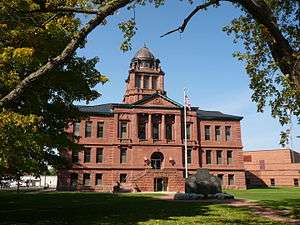 County courthouse in September 2014 | |
Logo | |
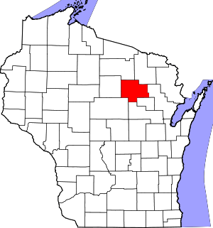 Location within the U.S. state of Wisconsin | |
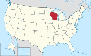 Wisconsin's location within the U.S. | |
| Coordinates: 45°13′00″N 89°00′00″W | |
| Country | |
| State | |
| Created | March 3, 1879 |
| Named for | Charles Michel de Langlade |
| Seat | Antigo |
| Largest city | Antigo |
| Area | |
| • Total | 888 sq mi (2,300 km2) |
| • Land | 871 sq mi (2,260 km2) |
| • Water | 17 sq mi (40 km2) 1.9%% |
| Population (2010) | |
| • Total | 19,977 |
| • Estimate (2018) | 19,268 |
| • Density | 22/sq mi (8.7/km2) |
| Time zone | UTC−6 (Central) |
| • Summer (DST) | UTC−5 (CDT) |
| Congressional district | 7th |
| Website | www |
History
Langlade County was created on March 3, 1879 as New County. It was renamed Langlade County, in honor of Charles de Langlade, on February 20, 1880, and fully organized on February 19, 1881.[3] The county's original borders extended northward from the top of Shawano County up to the Michigan state line. Between 1881 and 1885, the borders of Langlade County changed as nearby Lincoln and Shawano counties added or gave up area. Langlade lost its northernmost area along the Michigan border to Forest County when it was created in 1885.[4]
Geography
According to the U.S. Census Bureau, the county has a total area of 888 square miles (2,300 km2), of which 871 square miles (2,260 km2) is land and 17 square miles (44 km2) (1.9%) is water.[5] The highest point in the county is at the foot of the Basswood Lookout Tower west of Summit Lake (elev:1857')
Adjacent counties
- Oneida County - northwest
- Forest County - northeast
- Oconto County - east
- Menominee County - southeast
- Shawano County - south
- Marathon County - southwest
- Lincoln County - west
National protected area
- Nicolet National Forest (part)
Demographics
| Historical population | |||
|---|---|---|---|
| Census | Pop. | %± | |
| 1880 | 685 | — | |
| 1890 | 9,465 | 1,281.8% | |
| 1900 | 12,553 | 32.6% | |
| 1910 | 17,062 | 35.9% | |
| 1920 | 21,471 | 25.8% | |
| 1930 | 21,544 | 0.3% | |
| 1940 | 23,227 | 7.8% | |
| 1950 | 21,975 | −5.4% | |
| 1960 | 19,916 | −9.4% | |
| 1970 | 19,220 | −3.5% | |
| 1980 | 19,978 | 3.9% | |
| 1990 | 19,505 | −2.4% | |
| 2000 | 20,740 | 6.3% | |
| 2010 | 19,977 | −3.7% | |
| Est. 2018 | 19,268 | [6] | −3.5% |
| U.S. Decennial Census[7] 1790–1960[8] 1900–1990[9] 1990–2000[10] 2010–2018[1] | |||

As of the census[11] of 2000, there were 20,740 people, 8,452 households, and 5,814 families residing in the county. The population density was 24 people per square mile (9/km²). There were 11,187 housing units at an average density of 13 per square mile (5/km²). The racial makeup of the county was 97.93% White, 0.15% Black or African American, 0.54% Native American, 0.27% Asian, 0.02% Pacific Islander, 0.20% from other races, and 0.87% from two or more races. 0.82% of the population were Hispanic or Latino of any race. 49.4% were of German, 8.6% Polish, 6.2% Irish and 5.8% American ancestry.
There were 8,452 households out of which 29.40% had children under the age of 18 living with them, 56.70% were married couples living together, 8.20% had a female householder with no husband present, and 31.20% were non-families. 26.70% of all households were made up of individuals and 13.60% had someone living alone who was 65 years of age or older. The average household size was 2.42 and the average family size was 2.93.
In the county, the population was spread out with 24.40% under the age of 18, 6.50% from 18 to 24, 26.00% from 25 to 44, 24.30% from 45 to 64, and 18.80% who were 65 years of age or older. The median age was 40 years. For every 100 females there were 98.50 males. For every 100 females age 18 and over, there were 95.60 males.
In 2017, there were 196 births, giving a general fertility rate of 68.3 births per 1000 women aged 15–44, the 20th highest rate out of all 72 Wisconsin counties.[12] Additionally, there were 6 reported induced abortions performed on women of Langlade County residence in 2017.[13]
Transportation
Major highways


Airport
- KAIG - Langlade County Airport
The county owns and operates the Langlade County Airport which serves both the local and transient general aviation community.
Communities


City
- Antigo (county seat)
Village
Towns
Census-designated places
- Elcho
- Post Lake
- Summit Lake
Unincorporated communities
Ghost towns/neighborhoods
- Kent/Drexel
- Van Ostrand
Politics
| Year | Republican | Democratic | Third parties |
|---|---|---|---|
| 2016 | 63.6% 6,478 | 31.9% 3,250 | 4.5% 458 |
| 2012 | 55.3% 5,816 | 43.5% 4,573 | 1.2% 130 |
| 2008 | 48.9% 5,081 | 49.8% 5,182 | 1.3% 139 |
| 2004 | 56.3% 6,235 | 42.9% 4,751 | 0.8% 88 |
| 2000 | 52.7% 5,125 | 43.2% 4,199 | 4.1% 397 |
| 1996 | 37.2% 3,206 | 47.2% 4,074 | 15.7% 1,351 |
| 1992 | 38.7% 3,890 | 36.2% 3,630 | 25.1% 2,522 |
| 1988 | 53.2% 4,884 | 46.3% 4,254 | 0.5% 48 |
| 1984 | 60.9% 5,830 | 38.4% 3,675 | 0.7% 67 |
| 1980 | 49.3% 4,866 | 45.6% 4,498 | 5.1% 507 |
| 1976 | 51.9% 4,630 | 46.3% 4,134 | 1.9% 166 |
| 1972 | 57.3% 4,368 | 39.5% 3,011 | 3.3% 250 |
| 1968 | 49.4% 3,712 | 40.8% 3,064 | 9.8% 732 |
| 1964 | 37.1% 2,994 | 62.8% 5,077 | 0.1% 10 |
| 1960 | 53.3% 4,614 | 46.5% 4,025 | 0.2% 16 |
| 1956 | 63.8% 5,004 | 35.8% 2,804 | 0.4% 33 |
| 1952 | 63.0% 5,841 | 36.4% 3,371 | 0.6% 57 |
| 1948 | 42.6% 3,441 | 53.8% 4,346 | 3.6% 294 |
| 1944 | 48.2% 4,036 | 51.5% 4,310 | 0.3% 23 |
| 1940 | 46.1% 4,523 | 52.9% 5,190 | 1.0% 101 |
| 1936 | 30.3% 2,635 | 67.2% 5,837 | 2.4% 212 |
| 1932 | 26.4% 2,340 | 71.6% 6,332 | 2.0% 177 |
| 1928 | 47.2% 3,715 | 51.8% 4,078 | 1.1% 86 |
| 1924 | 36.0% 2,572 | 13.0% 926 | 51.1% 3,651 |
| 1920 | 68.7% 4,059 | 27.4% 1,619 | 4.0% 235 |
| 1916 | 45.1% 1,538 | 51.5% 1,755 | 3.5% 118 |
| 1912 | 23.4% 710 | 45.7% 1,387 | 30.9% 937 |
| 1908 | 57.2% 1,921 | 39.9% 1,340 | 2.9% 97 |
| 1904 | 65.7% 2,105 | 31.8% 1,018 | 2.5% 80 |
| 1900 | 58.4% 1,596 | 39.5% 1,080 | 2.1% 58 |
| 1896 | 58.8% 1,457 | 38.6% 956 | 2.6% 65 |
| 1892 | 38.4% 844 | 58.6% 1,289 | 3.0% 65 |
References
- "State & County QuickFacts". United States Census Bureau. Archived from the original on June 6, 2011. Retrieved January 21, 2014.
- "Find a County". National Association of Counties. Archived from the original on May 31, 2011. Retrieved June 7, 2011.
- "Wisconsin: Individual County Chronologies". Wisconsin Atlas of Historical County Boundaries. The Newberry Library. 2007. Retrieved August 14, 2015.
- "State and County Maps of Wisconsin". 2015-03-19. Archived from the original on March 19, 2015. Retrieved 2016-10-02.CS1 maint: BOT: original-url status unknown (link)
- "2010 Census Gazetteer Files". United States Census Bureau. August 22, 2012. Retrieved August 5, 2015.
- "Population and Housing Unit Estimates". Retrieved July 26, 2019.
- "U.S. Decennial Census". United States Census Bureau. Retrieved August 5, 2015.
- "Historical Census Browser". University of Virginia Library. Retrieved August 5, 2015.
- Forstall, Richard L., ed. (March 27, 1995). "Population of Counties by Decennial Census: 1900 to 1990". United States Census Bureau. Retrieved August 5, 2015.
- "Census 2000 PHC-T-4. Ranking Tables for Counties: 1990 and 2000" (PDF). United States Census Bureau. April 2, 2001. Retrieved August 5, 2015.
- "U.S. Census website". United States Census Bureau. Retrieved May 14, 2011.
- "Annual Wisconsin Birth and Infant Mortality Report, 2017 P-01161-19 (June 2019): Detailed Tables". Archived from the original on 2019-06-19. Retrieved 2019-06-19.
- Reported Induced Abortions in Wisconsin, Office of Health Informatics, Division of Public Health, Wisconsin Department of Health Services. Section: Trend Information, 2013-2017, Table 18, pages 17-18
- Leip, David. "Dave Leip's Atlas of U.S. Presidential Elections". uselectionatlas.org. Retrieved April 12, 2018.
Further reading
- Commemorative Biographical Record of the Upper Wisconsin Counties of Waupaca, Portage, Wood, Marathon, Lincoln, Oneida, Vilas, Langlade and Shawano. Chicago: J. H. Beers, 1895.
- Dessureau, Robert M. History of Langlade County, Wisconsin. Antigo, Wis.: Berner Bros., 1922.
External links
- Langlade County government website
- Langlade County map from the Wisconsin Department of Transportation
- Langlade County Historical Society
Places adjacent to Langlade County, Wisconsin | ||||||||||
|---|---|---|---|---|---|---|---|---|---|---|
| ||||||||||
Municipalities and communities of Langlade County, Wisconsin, United States | ||
|---|---|---|
| City | | |
| Village | ||
| Towns | ||
| CDPs | ||
| Unincorporated communities | ||
| Ghost towns/neighborhoods |
| |
| Authority control |
|
|---|