Brown County, Wisconsin
Brown County is a county in the U.S. state of Wisconsin. As of the 2010 census, the population was 248,007,[1] making it the fourth-most populous county in Wisconsin. The county seat is Green Bay.[2] Brown County is part of the Green Bay, WI Metropolitan Statistical Area.
Brown County | |
|---|---|
 Brown County Courthouse in Green Bay | |
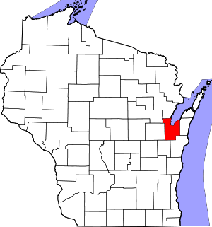 Location within the U.S. state of Wisconsin | |
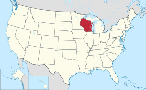 Wisconsin's location within the U.S. | |
| Coordinates: 44°29′N 87°59′W | |
| Country | |
| State | |
| Founded | 1818 |
| Named for | Jacob Brown |
| Seat | Green Bay |
| Largest city | Green Bay |
| Area | |
| • Total | 616 sq mi (1,600 km2) |
| • Land | 530 sq mi (1,400 km2) |
| • Water | 86 sq mi (220 km2) 14% |
| Population (2010) | |
| • Total | 248,007 |
| • Estimate (2019) | 264,542 |
| • Density | 400/sq mi (160/km2) |
| Time zone | UTC−6 (Central) |
| • Summer (DST) | UTC−5 (CDT) |
| Congressional district | 8th |
| Website | www |
History
.jpg)
Brown County is one of Wisconsin's two original counties, along with Crawford County. It originally spanned the entire eastern half of the state when formed by the Michigan Territorial legislature in 1818. It was named for Major General Jacob Brown,[3][4] a military leader during the War of 1812. The oldest known tree in Wisconsin, a 1,300 year-old cedar growing on the Niagara Escarpment, was found in Brown County.[5]
Geography
According to the U.S. Census Bureau, the county has a total area of 616 square miles (1,600 km2), of which 530 square miles (1,400 km2) is land and 86 square miles (220 km2) (14%) is water.[6]
Major highways
|
|
Climate
| ||||||||||||||||||||||||||||||||||||||||||||||||||||||||||||||||||||||||||||||||||||||||||||||||||||||||||||||||||||||||||||
Demographics
Birth related statistics
In 2017, there were 3,324 births, giving a general fertility rate of 65.6 births per 1000 women aged 15–44, which is above the Wisconsin average of 60.1.[8] Additionally, there were 168 reported induced abortions performed on women of Brown County residence, with a rate of 3.3 abortions per 1000 women aged 15–44, which is below the Wisconsin average rate of 5.2.[9]
| Historical population | |||
|---|---|---|---|
| Census | Pop. | %± | |
| 1840 | 2,107 | — | |
| 1850 | 6,215 | 195.0% | |
| 1860 | 11,795 | 89.8% | |
| 1870 | 25,168 | 113.4% | |
| 1880 | 34,078 | 35.4% | |
| 1890 | 39,164 | 14.9% | |
| 1900 | 46,359 | 18.4% | |
| 1910 | 54,098 | 16.7% | |
| 1920 | 61,889 | 14.4% | |
| 1930 | 70,249 | 13.5% | |
| 1940 | 83,109 | 18.3% | |
| 1950 | 98,314 | 18.3% | |
| 1960 | 125,082 | 27.2% | |
| 1970 | 158,244 | 26.5% | |
| 1980 | 175,280 | 10.8% | |
| 1990 | 194,594 | 11.0% | |
| 2000 | 226,778 | 16.5% | |
| 2010 | 248,007 | 9.4% | |
| Est. 2019 | 264,542 | [10] | 6.7% |
| U.S. Decennial Census[11] 1790–1960[12] 1900–1990[13] 1990–2000[14] 2010–2019[1] | |||
2010 census
At the 2010 census there were 248,007 people, 98,383 households, and 63,721 families living in the county. The population density was 403 people per square mile (156/km²). There were 104,371 housing units at an average density of 170 per square mile (66/km²). The racial makeup of the county was 86.5% White, 2.2% Black or African American, 2.7% Native American, 2.7% Asian, 0.0004% Pacific Islander, 3.7% from other races, and 2.2% from two or more races. 7.3% of the population were Hispanic or Latino of any race.[15] Of the 98,383 households 31.0% had children under the age of 18 living with them, 50.0% were married couples living together, 10.2% had a female householder with no husband present, and 35.2% were non-families. 27.7% of households were one person and 8.9% were one person aged 65 or older. The average household size was 2.45 and the average family size was 3.02.
The age distribution was 24.1% under the age of 18, 10.8% from 18 to 24, 26.9% from 25 to 44, 26.6% from 45 to 64, and 11.6% 65 or older. The median age was 36.2 years. For every 100 females, there were 97.80 males. For every 100 females age 18 and over, there were 95.70 males.
2000 census

At the 2000 census there were 226,778 people, 87,295 households, and 57,527 families living in the county. The population density was 429 people per square mile (166/km²). There were 90,199 housing units at an average density of 171 per square mile (66/km²). The racial makeup of the county was 91.14% White, 1.16% Black or African American, 2.29% Native American, 2.18% Asian, 0.03% Pacific Islander, 1.90% from other races, and 1.30% from two or more races. 3.84% of the population were Hispanic or Latino of any race. 33.8% were of German, 8.9% Polish, 7.8% Belgian and 6.8% Irish ancestry. 93.2% spoke only English at home, 3.8% spoke Spanish and 1.2% Hmong.[15] Of the 87,295 households 33.90% had children under the age of 18 living with them, 53.20% were married couples living together, 8.90% had a female householder with no husband present, and 34.10% were non-families. 26.50% of households were one person and 8.40% were one person aged 65 or older. The average household size was 2.51 and the average family size was 3.08.
The age distribution was 26.10% under the age of 18, 10.50% from 18 to 24, 31.90% from 25 to 44, 20.90% from 45 to 64, and 10.70% 65 or older. The median age was 34 years. For every 100 females, there were 98.90 males. For every 100 females age 18 and over, there were 96.90 males.
Government
The legislative branch of Brown County is the 26-member Board of Supervisors. Each member represents a single district and serves a two-year term, with elections held in the spring of even-numbered years. The Board of Supervisors elects a Chairman and Vice Chairman from its membership.
The executive branch of Brown County is the County Executive, who is elected in the spring of every other odd-numbered year. The executive appoints department heads with the approval of the County Board. The current county executive is Troy Streckenbach.
Brown County has several other elected officials that are established under the Wisconsin State constitution and are referred to as the "constitutional officers". Constitutional officers are the only partisan elected officials within Brown County government, as the Executive and County Board are non-partisan positions.
The current constitutional officers are:
- County Executive: Troy Streckenbach
- Clerk: Sandy Juno (R)
- Clerk of Circuit Courts: John Vander Leest (R)
- District Attorney: David L. Lasee (R)
- Register of Deeds: Cheryl Berken (R)
- Sheriff: Todd Delain (R)
- Treasurer: Paul Zeller (R)
In July 2002, the county declared English its official language, voting 17-8 to do so and to increase spending to promote fluency in English.
Communities


Villages
- Allouez
- Ashwaubenon
- Bellevue
- Denmark
- Hobart
- Howard (partly in Outagamie County)
- Pulaski (partly in Shawano County and Oconto County)
- Suamico
- Wrightstown (partly in Outagamie County)
Towns
Census-designated places
Unincorporated communities
- Anston
- Askeaton
- Benderville
- Bay Settlement
- Buckman
- Champion
- Chapel Ridge
- Coppens Corner
- Fontenoy
- Edgewater Beach
- Glenmore
- Henrysville
- Hollandtown
- Humboldt
- Kolb
- Kunesh
- Langes Corners
- Lark
- Little Rapids
- Mill Center
- Morrison
- New Franken
- Pine Grove
- Pittsfield (partial)
- Poland
- Red Banks
- Shirley
- Sniderville (partial)
- Sugar Bush
- Wayside
- Wequiock
Native American communities
- Oneida Nation of Wisconsin (partial)
Ghost towns/Neighborhoods
Adjacent counties
- Oconto County – north
- Kewaunee County – east
- Manitowoc County – southeast
- Calumet County – southwest
- Outagamie County – west
- Shawano County – northwest

Green Bay, center, is the seat of Brown County. The city of Oconto (half cut off at the bottom right) is the county seat of Oconto County. Slightly above and much further right of Oconto is Oconto Falls, also in Oconto County. The somewhat larger city above Oconto Falls is Pulaski, which is in Brown County at the very border with Shawano County. Shawano County extends between Pulaski and past the edge of the photograph.
The large city in the top right is Appleton, the county seat of Outagamie County. To the left of Appleton and across the northern edge of Lake Winnebago is Brillion in Calumet County.
The village directly to the left of Green Bay and its immediate suburbs is Denmark, in Brown County. The smaller communities above and slightly to the left of Denmark (including Cooperstown, Maribel, and Kellnersville) are in Manitowoc County.
Luxembourg (larger village in lower left) and Casco (half cut off at lower far left) are in Kewaunee County.]]
Politics
Since 1964, Brown County has voted for the Republican presidential candidate in all but two elections, 1996 and 2008.
| Year | Republican | Democratic | Third parties |
|---|---|---|---|
| 2016 | 52.1% 67,210 | 41.4% 53,382 | 6.5% 8,419 |
| 2012 | 50.3% 64,836 | 48.5% 62,526 | 1.2% 1,566 |
| 2008 | 44.8% 55,854 | 53.9% 67,269 | 1.3% 1,631 |
| 2004 | 54.5% 67,173 | 44.6% 54,935 | 1.0% 1,186 |
| 2000 | 50.4% 54,258 | 45.6% 49,096 | 4.1% 4,415 |
| 1996 | 42.5% 38,563 | 47.1% 42,823 | 10.4% 9,451 |
| 1992 | 41.2% 42,352 | 36.5% 37,513 | 22.2% 22,836 |
| 1988 | 50.8% 43,625 | 48.6% 41,788 | 0.6% 540 |
| 1984 | 62.4% 51,202 | 36.9% 30,218 | 0.7% 583 |
| 1980 | 56.7% 47,067 | 35.9% 29,796 | 7.4% 6,114 |
| 1976 | 50.6% 36,571 | 46.5% 33,572 | 2.9% 2,100 |
| 1972 | 56.5% 37,101 | 40.4% 26,511 | 3.1% 2,063 |
| 1968 | 53.7% 30,133 | 38.5% 21,615 | 7.8% 4,395 |
| 1964 | 40.6% 21,134 | 59.3% 30,851 | 0.2% 79 |
| 1960 | 49.7% 26,329 | 50.2% 26,577 | 0.1% 46 |
| 1956 | 70.2% 32,878 | 29.1% 13,642 | 0.6% 288 |
| 1952 | 67.8% 30,400 | 32.0% 14,342 | 0.2% 94 |
| 1948 | 48.5% 17,729 | 50.5% 18,449 | 1.0% 380 |
| 1944 | 50.1% 17,762 | 49.6% 17,576 | 0.3% 88 |
| 1940 | 45.5% 16,379 | 54.2% 19,526 | 0.4% 135 |
| 1936 | 27.1% 8,433 | 68.9% 21,417 | 4.0% 1,227 |
| 1932 | 25.9% 7,150 | 72.3% 19,990 | 1.8% 494 |
| 1928 | 36.0% 9,371 | 63.3% 16,465 | 0.7% 168 |
| 1924 | 37.9% 7,611 | 11.6% 2,328 | 50.5% 10,141 |
| 1920 | 61.7% 8,845 | 27.0% 3,877 | 11.3% 1,623 |
| 1916 | 40.0% 4,132 | 55.9% 5,771 | 4.1% 421 |
| 1912 | 32.8% 2,764 | 42.2% 3,557 | 25.1% 2,116 |
| 1908 | 55.3% 4,947 | 37.5% 3,354 | 7.3% 653 |
| 1904 | 65.8% 6,027 | 29.1% 2,667 | 5.0% 460 |
| 1900 | 56.8% 4,934 | 41.3% 3,588 | 1.9% 165 |
| 1896 | 57.5% 5,436 | 40.6% 3,841 | 1.9% 175 |
| 1892 | 42.4% 2,855 | 54.3% 3,653 | 3.3% 224 |
References
- "State & County QuickFacts". United States Census Bureau. Retrieved January 17, 2014.
- "Find a County". National Association of Counties. Archived from the original on May 31, 2011. Retrieved June 7, 2011.
- History of the Origin of the Place Names in Nine Northwestern States. 1908. p. 12.
- "Here's How Iron Got Its Name". The Rhinelander Daily News. June 16, 1932. p. 2. Retrieved August 24, 2014 – via Newspapers.com.

- The oldest known tree in Wisconsin is a 1,300-year-old cedar growing from a cliff
- "2010 Census Gazetteer Files". United States Census Bureau. August 22, 2012. Retrieved August 2, 2015.
- "NASA Earth Observations Data Set Index". NASA. Retrieved 30 January 2016.
- Annual Wisconsin Birth and Infant Mortality Report, 2017 P-01161-19 (June 2019): Detailed Tables
- Reported Induced Abortions in Wisconsin, Office of Health Informatics, Division of Public Health, Wisconsin Department of Health Services. Section: Trend Information, 2013-2017, Table 18, pages 17-18
- "Population and Housing Unit Estimates". Retrieved March 26, 2020.
- "U.S. Decennial Census". United States Census Bureau. Retrieved August 2, 2015.
- "Historical Census Browser". University of Virginia Library. Retrieved August 2, 2015.
- Forstall, Richard L., ed. (March 27, 1995). "Population of Counties by Decennial Census: 1900 to 1990". United States Census Bureau. Retrieved August 2, 2015.
- "Census 2000 PHC-T-4. Ranking Tables for Counties: 1990 and 2000" (PDF). United States Census Bureau. April 2, 2001. Retrieved August 2, 2015.
- "U.S. Census website". United States Census Bureau. Retrieved May 14, 2011.
- Leip, David. "Dave Leip's Atlas of U.S. Presidential Elections". uselectionatlas.org. Retrieved May 7, 2018.
Further reading
- Commemorative Biographical Record of the Fox River Valley Counties of Brown, Outagamie and Winnebago. Chicago: J. H. Beers, 1895.
- Martin, Deborah B. History of Brown Country Wisconsin: Past and Present. 2 vols. Chicago: S. J. Clarke, 1913. Vol. 1 Vol. 2
External links
- Brown County website
- Brown County map from the Wisconsin Department of Transportation
- Northeast Wisconsin Historical County Plat Maps & Atlases
Places adjacent to Brown County, Wisconsin | ||||||||||
|---|---|---|---|---|---|---|---|---|---|---|
| ||||||||||
| Core city |  | |
|---|---|---|
| Largest municipalities over 10,000 in 2010 | ||
| Municipalities under 10,000 in 2010 | ||
| Counties | ||
*town ‡village °city §CDP †unincorporated community ^partial | ||
Municipalities and communities of Brown County, Wisconsin, United States | ||
|---|---|---|
| Cities | | |
| Villages | ||
| Towns | ||
| CDPs | ||
| Unincorporated communities |
| |
| Indian reservation | ||
| Ghost towns/ neighborhoods | ||
| Footnotes | ‡This populated place also has portions in an adjacent county or counties | |
| Authority control |
|
|---|