Buffalo County, Wisconsin
Buffalo County is a county located in the U.S. state of Wisconsin. As of the 2010 census, the population was 13,587.[1] Its county seat is Alma.[2] The county was created in 1853 and organized the following year.[3][4]
Buffalo County | |
|---|---|
 Alma Area Museum in Old Buffalo County Training School and Teachers College Building in Alma, Wisconsin. | |
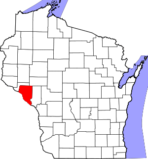 Location within the U.S. state of Wisconsin | |
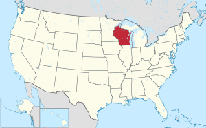 Wisconsin's location within the U.S. | |
| Coordinates: 44°23′N 91°45′W | |
| Country | |
| State | |
| Founded | 1854 |
| Named for | Buffalo River |
| Seat | Alma |
| Largest city | Mondovi |
| Area | |
| • Total | 710 sq mi (1,800 km2) |
| • Land | 672 sq mi (1,740 km2) |
| • Water | 38 sq mi (100 km2) 5.3% |
| Population (2010) | |
| • Total | 13,587 |
| • Estimate (2018) | 13,125 |
| • Density | 19/sq mi (7.4/km2) |
| Time zone | UTC−6 (Central) |
| • Summer (DST) | UTC−5 (CDT) |
| Congressional district | 3rd |
| Website | www |
History
Buffalo County, founded in 1853, is named for the Buffalo River, which flows from Strum to Alma, where it empties into the Mississippi River. The Buffalo River obtained its name from the French voyager Father Louis Hennepin, who named it Riviere des Boeufs in 1680. The first permanent settlement was established in 1839, located in what is now Fountain City. This settlement was originally named Holmes' Landing after a family who traded with the Sioux and Chippewa. Buffalo County was settled primarily by Swiss, German, and Norwegian immigrants who were drawn to the area by the growing lumber industry, fertile soils, access to the Mississippi, and available land. By 1848, a second community was established called Twelve Mile Bluff, which is now known as Alma.
Agriculture developed during the 1850s on top of the ridges where natural prairies and oak savannas occurred, which made working the land much easier. With the lack of good roads, settlement remained along the Mississippi River, where farmers could ship their grain on steamboats. The development of the Northern Rail from Winona, Minnesota, allowed for development away from the river, and by 1890, farmers were transporting their goods predominantly by rail.
The Civil War gave a boost to the local economy with the rising demand for wheat, which was the main crop of the county. The postwar period brought a large influx of settlers; however, because of declining soil fertility, many moved west rather than adopt crop rotation and fertilization. With the price of wheat falling, farmers turned to dairy farming, and by the 1880s, local creameries had started to appear.
Geography
According to the U.S. Census Bureau, the county has a total area of 710 square miles (1,800 km2), of which 672 square miles (1,740 km2) are land and 38 square miles (98 km2) (5.3%) are covered by water.[5]
Adjacent counties
- Pepin County – north
- Eau Claire County – northeast
- Trempealeau County – east
- Winona County, Minnesota – south
- Wabasha County, Minnesota – west
Major highways
|
|
Demographics
| Historical population | |||
|---|---|---|---|
| Census | Pop. | %± | |
| 1860 | 3,864 | — | |
| 1870 | 11,123 | 187.9% | |
| 1880 | 15,528 | 39.6% | |
| 1890 | 15,997 | 3.0% | |
| 1900 | 16,765 | 4.8% | |
| 1910 | 16,006 | −4.5% | |
| 1920 | 15,615 | −2.4% | |
| 1930 | 15,330 | −1.8% | |
| 1940 | 16,090 | 5.0% | |
| 1950 | 14,719 | −8.5% | |
| 1960 | 14,202 | −3.5% | |
| 1970 | 13,743 | −3.2% | |
| 1980 | 14,309 | 4.1% | |
| 1990 | 13,584 | −5.1% | |
| 2000 | 13,804 | 1.6% | |
| 2010 | 13,587 | −1.6% | |
| Est. 2018 | 13,125 | [6] | −3.4% |
| U.S. Decennial Census[7] 1790–1960[8] 1900–1990[9] 1990–2000[10] 2010–2018[1] | |||

As of the census[11] of 2000, there were 13,804 people, 5,511 households, and 3,780 families residing in the county. The population density was 20 people per square mile (8/km²). There were 6,098 housing units at an average density of 9 per square mile (3/km²). The racial makeup of the county was 98.69% White, 0.12% Black or African American, 0.30% Native American, 0.33% Asian, 0.02% Pacific Islander, 0.08% from other races, and 0.46% from two or more races. 0.62% of the population were Hispanic or Latino of any race. 44.3% were of German, 22.1% Norwegian and 8.8% Polish ancestry. 96.9% spoke English, 1.6% Spanish and 1.1% German as their first language.
There were 5,511 households out of which 30.80% had children under the age of 18 living with them, 58.90% were married couples living together, 6.20% had a female householder with no husband present, and 31.40% were non-families. 27.10% of all households were made up of individuals and 12.60% had someone living alone who was 65 years of age or older. The average household size was 2.47 and the average family size was 3.01.
In the county, the population was spread out with 25.10% under the age of 18, 6.90% from 18 to 24, 27.60% from 25 to 44, 23.70% from 45 to 64, and 16.80% who were 65 years of age or older. The median age was 39 years. For every 100 females there were 100.70 males. For every 100 females age 18 and over, there were 101.40 males.
In 2017, there were 121 births, giving a general fertility rate of 58.4 births per 1000 women aged 15–44, the 22nd lowest rate out of all 72 Wisconsin counties. 33 of the births were to unmarried mothers, 88 to married mothers.[12] Additionally, there were fewer than five reported induced abortions performed on women of Buffalo County residence in 2017.[13]
Communities
Cities
- Alma (county seat)
- Buffalo City
- Fountain City
- Mondovi

Towns
Census-designated places
- Gilmanton
- Waumandee
Other unincorporated communities
Ghost towns/neighborhoods
Politics
| Year | Republican | Democratic | Third parties |
|---|---|---|---|
| 2016 | 58.0% 4,048 | 36.2% 2,525 | 5.9% 408 |
| 2012 | 47.8% 3,364 | 50.7% 3,570 | 1.5% 105 |
| 2008 | 41.8% 2,923 | 56.4% 3,949 | 1.8% 128 |
| 2004 | 46.1% 3,502 | 52.7% 3,998 | 1.2% 91 |
| 2000 | 45.8% 3,038 | 48.7% 3,237 | 5.5% 366 |
| 1996 | 32.4% 1,800 | 48.3% 2,681 | 19.4% 1,076 |
| 1992 | 29.2% 2,029 | 43.1% 2,996 | 27.7% 1,925 |
| 1988 | 44.1% 2,783 | 55.1% 3,481 | 0.8% 49 |
| 1984 | 52.7% 3,325 | 46.3% 2,921 | 0.9% 58 |
| 1980 | 48.1% 3,569 | 44.2% 3,276 | 7.7% 573 |
| 1976 | 44.3% 2,844 | 53.7% 3,448 | 2.1% 135 |
| 1972 | 54.4% 3,079 | 43.5% 2,461 | 2.1% 120 |
| 1968 | 54.2% 2,992 | 38.3% 2,112 | 7.5% 415 |
| 1964 | 36.3% 2,091 | 63.6% 3,663 | 0.1% 5 |
| 1960 | 55.4% 3,464 | 44.6% 2,790 | 0.0% 2 |
| 1956 | 59.8% 3,387 | 40.0% 2,266 | 0.1% 8 |
| 1952 | 67.9% 4,233 | 31.9% 1,988 | 0.2% 11 |
| 1948 | 47.1% 2,350 | 51.3% 2,563 | 1.6% 80 |
| 1944 | 63.2% 3,416 | 36.0% 1,948 | 0.8% 42 |
| 1940 | 60.8% 4,056 | 37.7% 2,516 | 1.5% 103 |
| 1936 | 40.1% 2,481 | 55.4% 3,434 | 4.5% 279 |
| 1932 | 34.0% 1,711 | 64.7% 3,252 | 1.3% 65 |
| 1928 | 61.9% 3,027 | 37.5% 1,836 | 0.6% 29 |
| 1924 | 33.1% 1,324 | 4.4% 176 | 62.6% 2,506 |
| 1920 | 85.4% 3,082 | 8.3% 299 | 6.3% 228 |
| 1916 | 56.5% 1,492 | 39.5% 1,043 | 3.9% 104 |
| 1912 | 48.7% 1,239 | 33.3% 848 | 18.1% 460 |
| 1908 | 63.7% 1,937 | 33.8% 1,027 | 2.5% 76 |
| 1904 | 68.4% 2,147 | 29.0% 911 | 2.6% 83 |
| 1900 | 62.4% 2,091 | 36.0% 1,205 | 1.6% 55 |
| 1896 | 61.9% 2,301 | 35.0% 1,302 | 3.1% 115 |
| 1892 | 49.5% 1,523 | 45.2% 1,393 | 5.3% 163 |
Notable people
- Chauncey H. Cooke (1846–1919), American soldier in the U.S. Civil War[15]
See also
References
- "State & County QuickFacts". United States Census Bureau. Retrieved January 17, 2014.
- "Find a County". National Association of Counties. Archived from the original on May 31, 2011. Retrieved June 7, 2011.
- "Archived copy". Archived from the original on December 20, 2007. Retrieved November 12, 2007.CS1 maint: archived copy as title (link)
- "Wisconsin: Individual County Chronologies". Wisconsin Atlas of Historical County Boundaries. The Newberry Library. 2007. Retrieved August 12, 2015.
- "2010 Census Gazetteer Files". United States Census Bureau. August 22, 2012. Retrieved August 2, 2015.
- "Population and Housing Unit Estimates". Retrieved July 26, 2019.
- "U.S. Decennial Census". United States Census Bureau. Retrieved August 2, 2015.
- "Historical Census Browser". University of Virginia Library. Retrieved August 2, 2015.
- Forstall, Richard L., ed. (March 27, 1995). "Population of Counties by Decennial Census: 1900 to 1990". United States Census Bureau. Retrieved August 2, 2015.
- "Census 2000 PHC-T-4. Ranking Tables for Counties: 1990 and 2000" (PDF). United States Census Bureau. April 2, 2001. Retrieved August 2, 2015.
- "U.S. Census website". United States Census Bureau. Retrieved May 14, 2011.
- Annual Wisconsin Birth and Infant Mortality Report, 2017 P-01161-19 (June 2019): Detailed Tables
- Reported Induced Abortions in Wisconsin, Office of Health Informatics, Division of Public Health, Wisconsin Department of Health Services. Section: Trend Information, 2013-2017, Table 18, pages 17-18
- Leip, David. "Dave Leip's Atlas of U.S. Presidential Elections". uselectionatlas.org. Retrieved May 7, 2018.
- Mulligan, William H., Jr.; Cooke, Chauncey Herbert (2007). A Badger Boy in Blue: The Civil War Letters of Chauncey H. Cooke. Detroit, Michigan: Wayne State University Press. p. 1. ISBN 978-0-8143-3343-3. Retrieved March 29, 2016.
Further reading
- Biographical History of La Crosse, Trempealeau and Buffalo Counties, Wisconsin. Chicago: Lewis Publishing, 1892.
- Curtiss-Wedge, Franklyn (ed.). History of Buffalo and Pepin Counties Wisconsin. Winona, Minn.: H. C. Cooper, 1919.
- Kessinger, L. History of Buffalo County, Wisconsin. Alma, Wis.: 1888.
External links
| Wikisource has the text of an 1879 American Cyclopædia article about Buffalo County, Wisconsin. |
- Buffalo County government website
- Buffalo County map from the Wisconsin Department of Transportation
Places adjacent to Buffalo County, Wisconsin | ||||||||||
|---|---|---|---|---|---|---|---|---|---|---|
| ||||||||||
Municipalities and communities of Buffalo County, Wisconsin, United States | ||
|---|---|---|
| Cities | | |
| Villages | ||
| Towns | ||
| CDPs | ||
| Unincorporated communities | ||
| Ghost towns/neighborhoods | ||
| Authority control |
|
|---|