Mato Leitão
Mato Leitão is a municipality in the state of Rio Grande do Sul, Brazil.
Mato Leitão | |
|---|---|
Município/City | |
| Município de Mato Leitão | |
 Flag  Seal | |
| Nickname(s): Capital of Ochids | |
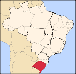
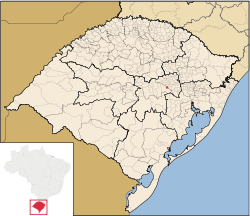 Location within Rio Grande do Sul | |
 Mato Leitão Location in the Brazil | |
| Coordinates: 29°31′32″S 52°07′36″W[1] | |
| Emancipação | March 20, 1992 |
| Government | |
| • Type | Mayor government |
| • Body | Prefeitura de Mato Leitão |
| • Prefeito(a) | Carmen Goerck, PP |
| Area | |
| • Total | 17.7 sq mi (46 km2) |
| Elevation | 266 ft (81 m) |
| Population | |
| • Total | 3,964 |
| • Density | 220/sq mi (86/km2) |
| • Urban | 1,621 |
| • Urbanization Rate (2010) | 41.9% |
| Demonym(s) | Matoleitoense |
| Time zone | UTC-3 (UTC-3) |
| • Summer (DST) | UTC-2 (UTC-2) |
| ZIP code(s) | 95835000 |
| Website | www |
Geography
Mato Leitão is located at a latitude 29º31'28" south and a longitude 52º07'43" west, being at a altitude of 81 meters (266 feet).
It has an area of 45.9 km² (17.7 mi²) and a population of 3 869 inhabitants (2010).
In the main avenue of the city, Leopoldo A. Hinterholz Av., are located the cathedral, the prefecture, the SEUBV and most of the local trade.
Culture and Economy
Known as the "Capital of the beautiful woman" and the "City of Orchids", Mato Leitão is a city of German colonization that has its economy based on agriculture - especially corn and tobacco - and food and footwear industry.
It's a peaceful place, where you can find typical German cookery and festivities. A curiosity is that there are many localities in Mato Leitão where people talk preferentially speak German to Portuguese.
Quality of Life
There are 4 schools in Mato Leitão, only 1 with High Schools' studies. However, Mato Leitão is considered as a reference in education, being in the top 15 at the state. Similarly, public health is a source of pride.
As an example, Mato Leitão has a 96.2% literacy rate and HDI of 0.746.
Also, Mato Leitão is a very safe place, where crimes like thefts and murders are extremely rare.
References
- "US Gazetteer files: 2010, 2000, and 1990". United States Census Bureau. 2011-02-12. Retrieved 2011-04-23.
- Mato Leitão, Prefeitura Municipal de (May 1, 2014). "Official Site". Mato Leitão, Prefeitura Municipal de. Retrieved May 1, 2014.
- "US Board on Geographic Names". United States Geological Survey. 2007-10-25. Retrieved 2008-01-31.
External links
- FEEDADOS: http://feedados.fee.tche.br/
- Municipal Anthem: http://pt.wikisource.org/wiki/Hino_do_munic%C3%ADpio_de_Mato_Leit%C3%A3o