Capão do Cipó
Capão do Cipó is a municipality of the western part of the state of Rio Grande do Sul, Brazil. The population is 3,387 (2015 est.) in an area of 1,120.87 km².[1] The economy is mainly agricultural and it contains 500 square kilometres of soybean production.
Capão do Cipó | |
|---|---|
 Flag  Coat of arms | |
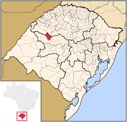 Location in Rio Grande do Sul state | |
 Capão do Cipó Location in Brazil | |
| Coordinates: 28°56′4″S 54°33′22″W | |
| Country | Brazil |
| Region | South |
| State | Rio Grande do Sul |
| Mesoregion | Centro Ocidental Rio-Grandense |
| Microregion | Santiago |
| Area | |
| • Total | 1,120.87 km2 (432.77 sq mi) |
| Population (2015) | |
| • Total | 3,387 |
| • Density | 3.0/km2 (7.8/sq mi) |
| Time zone | UTC-03:00 (BRT) |
| • Summer (DST) | UTC-02:00 (BRST) |
| Postal code | 98870-xxx |
| Website | www |
This article is issued from Wikipedia. The text is licensed under Creative Commons - Attribution - Sharealike. Additional terms may apply for the media files.