Gramado
Gramado is a small tourist city, southeast of Caxias do Sul and east of Nova Petrópolis in the southern Brazilian state of Rio Grande do Sul, in the Serra Gaúcha region. The city was originally settled by Azorean descendants and later received a contingent of German and Italian immigrants. Gramado is one of the cities along the scenic route known as Rota Romântica (Romantic Route).
Gramado | |
|---|---|
Town | |
 | |
 Flag  Seal | |
| Nickname(s): Hydrangeas' Garden | |
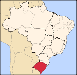
 Geographical subdivisions of Rio Grande do Sul. Gramado is highlighted with red. | |
| Coordinates: 29°24′17″S 50°52′35″W | |
| Country | |
| State | South |
| State | |
| Incorporated | December 15, 1954 |
| Government | |
| • Mayor | Nestor Tissot |
| Area | |
| • Total | 237 km2 (92 sq mi) |
| Elevation | 850 m (2,790 ft) |
| Population (2007)[1] | |
| • Total | 31,655 |
| • Density | 133.6/km2 (346/sq mi) |
| • Demonym | Gramadense |
| Time zone | UTC-3 |
| • Summer (DST) | UTC-2 |
| Website | Gramado, Rio Grande do Sul |
History
Gramado was originally settled in 1875 by Portuguese immigrants. Five years later, the first German immigrants arrived and these were followed shortly after by Italian immigrants from the Italian settlements in Caxias do Sul.
In 1913, the city seat was moved to Linha Nova, the location of the present-day city center. At this time, Gramado was an unincorporated city within the city of Taquara. A railway, brought by Gramado's founder and first administrator, José Nicoletti Filho, arrived in the city in 1921, boosting the local economy. Gramado officially became a city in 1937, when Gramado was already known as a summer holiday resort. Gramado became a city on December 15, 1954 by force of State Act 2,522.[2]
Politics and Government
Gramado Government is in a strong mayor-council government model, as set forth by the Brazilian Constitution of 1988. Elections for both mayoral and legislative offices are held every fourth year. The Mayor may seek reelection once, while Councilmen have no restriction on terms they may serve.
Executive Branch
Executive powers are held by the Mayor of Gramado, who appoints a Cabinet, the heads of several municipal bodies and members of the Planning Commission. The current Mayor is Nestor Tissot[3] (PP) elected in 2008. The current Deputy Mayor is Luia Barbacovi.[4] In the election of 2016 the opposition candidate won, thereby Fedoca Bertolucci takes the City Hall on January 1, 2017.
Geography
Open spaces
Gramado has several green areas, the most important are Black Lake, Communications Square, Knorr Park, Orchard Park, Major Nicoletti Square and, Roses Square.
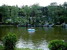
Lago Negro
Lago Negro (Black Lake) is the most known, visited green area of Gramado. It was created[5] in 1953 by Leopoldo Rosenfeld on an area it was the biggest woods of the Hydrangeas' Region, this very area had been destroyed by fire in 1942. It was named after Good Rest Valley (Vale do Bom Retiro) before fire.
A creek was dammed up to create[6] a U-shaped lake. Rosenfeld imported pine seedlings from Black Forest in Germany to be planted all around the newly formed lake's rim.
Lago Negro is a mile away from Town Hall. There is a boathouse, working daily from 8:30 AM to 7:00 PM, concession stands and a small craftsmen fair nearby.
Climate
The climate is maritime temperate with mild summer (Cfb, according to the Köppen climate classification). The summers are not usually hot, with temperatures around 22 °C (72 °F). There are some hotter days, but with always pleasant evenings, moderated by mountain air and forests. Winters are cool, with temperatures sometimes falling below 0 °C (32 °F), heavy frosts and occasional snowfall.
| Climate data for Gramado | |||||||||||||
|---|---|---|---|---|---|---|---|---|---|---|---|---|---|
| Month | Jan | Feb | Mar | Apr | May | Jun | Jul | Aug | Sep | Oct | Nov | Dec | Year |
| Average high °C (°F) | 25.6 (78.1) |
24.8 (76.6) |
22.9 (73.2) |
19.9 (67.8) |
17.6 (63.7) |
16.7 (62.1) |
16.9 (62.4) |
18.1 (64.6) |
19.3 (66.7) |
21.4 (70.5) |
23.4 (74.1) |
23.2 (73.8) |
20.8 (69.5) |
| Average low °C (°F) | 15.8 (60.4) |
15.4 (59.7) |
13.6 (56.5) |
10.9 (51.6) |
8.7 (47.7) |
7.7 (45.9) |
7.5 (45.5) |
8.4 (47.1) |
9.6 (49.3) |
11.4 (52.5) |
13.0 (55.4) |
13.1 (55.6) |
11.3 (52.3) |
| Average rainfall mm (inches) | 168 (6.6) |
168 (6.6) |
184 (7.2) |
152 (6.0) |
143 (5.6) |
175 (6.9) |
163 (6.4) |
170 (6.7) |
197 (7.8) |
177 (7.0) |
136 (5.4) |
163 (6.4) |
1,996 (78.6) |
| Source: Climate Data | |||||||||||||
Culture and tourism
The city is in a mountain range, averaging 850 meters above sea level. Visitors from Northern Hemisphere mid-latitudes may notice several tree species (including Red Maple, American Sweetgum and American Tuliptree) common to their home territory in cultivation here, flourishing among the native Parana Pine.
- Festival de Gramado, a major South American film festival and Gramado's most important event;
- Hydrangeas blossoming in late spring;
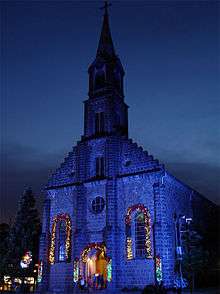
- Natal Luz, Christmas festival, the largest in Brazil.
Sister cities
Gramado has five sister cities:[7]
References
- "Gramado, história de uma terra e seu povo ." Inema - Seu site de aventuras. 8 Sep 2006 <https://web.archive.org/web/20060221223030/http://inema.com.br/mat/idmat030671.htm>.
- "História." City Brazil. 8 Sep 2006 <https://web.archive.org/web/20070322175050/http://www.citybrazil.com.br/rs/gramado/historia.htm>.
Notes
- "Gramado." RESUMO ESTATÍSTICO RS - Municípios. Fundação de Economia e Estatística. 9 Sep 2006 <http://www.fee.rs.gov.br/sitefee/pt/content/resumo/pg_municipios_detalhe.php?municipio=Gramado>.
- "Lei Nº 2.522, de 15 de Dezembro de 1954." Estado do Rio Grande do Sul - Assembleia Legislativa. 1 May 2009 <http://www.al.rs.gov.br/legiscomp/arquivo.asp?Rotulo=Lei%20nº%202522&idNorma=585&tipo=pdf>.
- "Prefeitura de Gramado - O Prefeito." Prefeitura de Gramado. Prefeitura Municipal de Gramado. 1 May 2009 <http://www.gramado.rs.gov.br/index.php/Gabinete-do-Prefeito/O-Prefeito.html Archived 20 April 2009 at the Wayback Machine>.
- Prefeitura de Gramado - "O Vice-Prefeito." Prefeitura de Gramado. Prefeitura Municipal de Gramado. 1 May 2009 <http://www.gramado.rs.gov.br/index.php/Gabinete-do-Prefeito/O-Vice-Prefeito.html Archived 20 April 2009 at the Wayback Machine>.
- "Gramado." BrasilViagem.com. 15 Sept. 2006 <http://www.brasilviagem.com/pontur/?CodAtr=3128 Archived 16 May 2006 at the Wayback Machine>.
- Barbosa, Eliane. "Pousadas de Gramado." Jornal da Cidade 21 July 2005. 15 Sept. 2006 <https://jcnet.uol.com.br/cadernos/detalhe_turismo.php?codigo=54780%5B%5D.
- "Prefeito de Gramado viaja ao Espírito Santo." 3 Nov. 2005. Prefeitura de Gramado. 15 Sept. 2006 <http://www.gramado.rs.gov.br/content/view/497/39/ Archived 4 March 2006 at the Wayback Machine>.
External links
| Wikimedia Commons has media related to Gramado. |
Government Websites
Maps
Media Outlets
Touristic Websites
- Insider Guide of Gramado
- Gramado and Canela Tourist Guide
- Gramado Tourist Guide
- Hotels in Gramado
- Tourism and services Guide
- What to do in Gramado

Official Events Websites