Caçapava do Sul
Caçapava do Sul is a Brazilian municipality in the state of Rio Grande do Sul, located on the banks of the Camaquã River. As of 2016, the city has an estimated population of 34,664.[2] It was the 2nd capital of the Piratini Republic from 1839 to 1840.
Município de Caçapava do Sul | |
|---|---|
 Flag  Seal | |
| Motto(s): Caçapava não se entrega (Caçapava doesn't surrender) | |
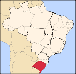
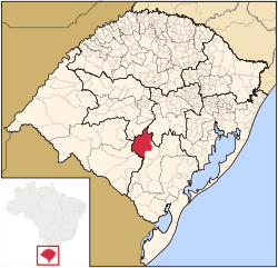 Location within Rio Grande do Sul | |
| Coordinates: 30°30′44″S 53°29′27″W | |
| Country | Brazil |
| Region | South |
| State | Rio Grande do Sul |
| Meso-region | Sudeste Rio-Grandense |
| Micro-region | Serras de Sudeste |
| Founded | 25 October 1831 |
| Government | |
| • Mayor | Giovani Amestoy da Silva (PDT) (2017–2020) |
| Area | |
| • Total | 3,047.120 km2 (1,176.500 sq mi) |
| Elevation | 444 m (1,457 ft) |
| Population (2010)[1] | |
| • Total | 33 690 |
| • Estimate (2016)[2] | 34 644 |
| • Density | 11.06/km2 (28.6/sq mi) |
| Demonym(s) | Caçapavano(a) |
| Time zone | UTC-3 (BRT) |
| • Summer (DST) | UTC-2 (BRST) |
| Postal code | 96570 |
| Area code(s) | (+55) 55 |
| HDI | 0.768 (medium) UNDP/2000 |
| GDP | R$ 369,279,689 IBGE/2008 |
| Website | www |
The economy depends primarily on the mining industry. Caçapava do Sul produces 80% of the calcareous rock mined in Rio Grande do Sul. For many years it was Brazil's major producer of copper and is still an important center of copper mining.
A major deposit of copper ore was discovered in the 1940s by the CBC (Companhia Brasileira do Cobre / Brazilian Copper Company), under the direction of Brazilian industrialist and famous playboy Francisco "Baby" Pignatari. The area, about 5 kilometers from Caçapava, came to be known as the Minas do Camaquã (Camaquã Mines). This large operation contributed enormously to the town's economy and is still the site of operating copper mines, by such companies as Majestic Diamonds & Metals.
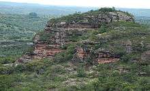
The area has several interesting natural formations. Nearby lies Pedra do Segredo (Stone of the Secret), a natural outcropping of stone that attracts mountain climbers and tourists from all over the state and elsewhere.
Geography
The city is located at latitude 30º30'44"S and longitude 53º29'29"W, at an altitude of 444 meters (1,443 ft). It has a geographical area of 3,044.8 km².
Main tourist attractions
- Pedra do Segredo (Stone of the Secret)
- Dom Pedro II Fort
- Cascata do Salso (Salso Waterfall)
- Minas do Camaquã (Camaquã Mines)
- Casa de Borges de Medeiros (Borges of Medeiros' House)
- Casa dos Ministérios – Farrapos (House of the Ministers of Poverty, literally "Ministries of Tatters")
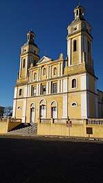
- Igreja Matriz Nossa Sra Assunção (Our Lady of Assumption Church and compound)
- Guaritas (considered the 7th natural wonder of Rio Grande do Sul)
Nearby Municipalities
References
- "Population data of Caçapava do Sul" (in Portuguese). Brazilian Institute of Geography and Statistics. Retrieved 18 July 2017.
- "Estimativas da população residente no Brasil e unidades da Federação com data de referência em 1º de julho de 2016" [Estimates of the resident population in Brazil and in the Federative Units with a reference date on July 1, 2016] (PDF) (in Portuguese). Brazilian Institute of Geography and Statistics. 1 July 2016. Retrieved 18 July 2017.