Alvorada
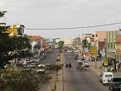
Alvorada is a city in Rio Grande do Sul, Brazil, adjacent to the city of Porto Alegre. The city is also known as "The Capital of Solidarity." Alvorada is primarily a bedroom community with most workers commuting to adjacent cities such as Porto Alegre to work. Alvorada is built around its main road: Avenida Presidente Vargas. The name means "the awakening" or "the sunrise".
City of Alvorada | |
|---|---|
 | |
 Flag  Seal | |
| Nickname(s): Capital of Solidarity | |
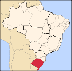
 Location in Rio Grande do Sul, Brazil | |
| Coordinates: 29°59′24″S 51°05′02″W | |
| Country | Brazil |
| Region | South |
| State | Rio Grande do Sul |
| Founded | 1965 |
| Government | |
| • Mayor | Jose Arno Appolo do Amaral (MDB) |
| Area | |
| • Total | 70.811 km2 (27.340 sq mi) |
| Elevation | 17 m (56 ft) |
| Population (2018 est.[1]) | |
| • Total | 209,213 |
| • Density | 3,000/km2 (7,700/sq mi) |
| Time zone | UTC-3 (BRT) |
| • Summer (DST) | UTC-2 (BRST) |
| Postal code | 94810 |
| Area code(s) | (+55) 51 |
| Website | alvorada.rs.gov.br (in Portuguese) |
Although improvements have been made, the city suffers from heavy crime and squatting. The largest of these slums or favelas is the dangerous Umbu subdivision. Drug and arms trafficking are punctuated by periodic violence.
Geographia
Alvorada makes currency with the municipalities of Porto Alegre, Viamão, Gravataí and Cachoeirinha.
In their territory through the rodovia RS - 118.
Is close to Porto Alegre about 16 kilometres.
The growth of the municipality has been on the verge of President Avenida Vargas main through the city centre.
The economy is based mainly on trade and industry, and the vast majority of the population work in the municipality of Porto Alegre, causing the city is also known as a city sleeper.
The city of Porto Alegre is separated by Arroyo feijó. This Arroyo has always been very important to alvorada. Was it that residents older city retivaravam water for consumption.
The municipality has 01 public hospital and more 34 health facilities (between public and private).
In the area of education there are 46 establishments pre-school (public and private), 45 School (public and private), 11 School (public and private) and of higher education (private)
References
- "Brazilian Institute of Geography and Statistics" (PDF) (in Portuguese). 2018. Retrieved 6 March 2019.
2018 Estimates of Population
External links
- Photos of Alvorada
- Alvorada City Hall (in Portuguese)