Kovačica
Kovačica (Serbian Cyrillic: Ковачица; pronounced [koʋǎtʃitsa]) is a town and municipality located in the South Banat District of the autonomous province of Vojvodina, Serbia. According to the 2011 census, the town has a population of 6,259, while Kovačica municipality has 25,274 inhabitants.[1] It is widely known for its naïve art that the local residents make without any form of art school.
Kovačica Ковачица Kovačica | |
|---|---|
Town and municipality | |
_Church.jpg) The Evangelical (Slovak) church | |
 Coat of arms | |
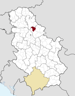 Location of Kovačica within Serbia | |
| Coordinates: 45°6′42″N 20°37′17″E | |
| Country | |
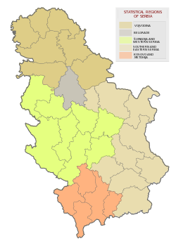
| Province | Vojvodina |
| District | South Banat |
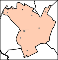
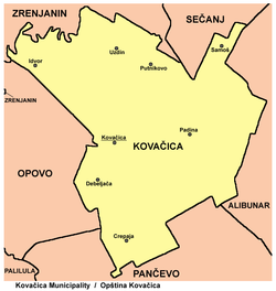
| Settlements | 8 |
| Government | |
| • Mayor | Milan Garašević |
| Area | |
| • Municipal | 419 km2 (162 sq mi) |
| Elevation | 78 m (256 ft) |
| Population (2011) | |
| • Municipal | 25,274 |
| • Density | 60/km2 (160/sq mi) |
| • Urban | 6,259 |
| Time zone | UTC+1 (CET) |
| • Summer (DST) | UTC+2 (CEST) |
| Postal code | 26210 |
| Area code(s) | +381(0)13 |
| Car plates | PA |
| Website | www.kovacica.org |
Geography
The town of Kovačica is located 27 km from Pančevo and 43 km from Belgrade. Kovačica lies in the wide Pannonian plain.
History
The town was founded in the 18th century, but there are records of small settlements dating from 1458. In the middle of the 18th century, this area was recorded as wasteland. Settlement was founded in 1750 and was settled (in 1751-1752) by Serb soldiers from Potisje and Pomorišje, after military frontier in these regions was abolished. In 1767, Kovačica was included into German regiment of Banatian Military Frontier. First Slovaks came here from Ečka and Aradac (in 1783) and after them, Slovaks from Arvas, Trenčin and Bekeš county came here as well (in 1801). From the middle of the 19th century, Kovačica is a center of municipality and cultural and social center of Slovaks in Banat.[2]
Settlements
Kovačica municipality includes the town of Kovačica and the following villages:
The municipality is divided into 8 local communities.
Demographics
| Historical population | ||
|---|---|---|
| Year | Pop. | ±% p.a. |
| 1948 | 31,682 | — |
| 1953 | 32,808 | +0.70% |
| 1961 | 34,654 | +0.69% |
| 1971 | 33,489 | −0.34% |
| 1981 | 32,798 | −0.21% |
| 1991 | 30,469 | −0.73% |
| 2002 | 27,890 | −0.80% |
| 2011 | 25,274 | −1.09% |
| Source: [3] | ||
According to the last official census done in 2011, the municipality of Kovačica has 25,274 inhabitants, with 6,259 in town area.
Ethnic groups
Communities with Slovak majorities are: Kovačica (Slovak: Kovačica) and Padina (Slovak: Padina). Communities with Serb majorities are: Crepaja, Idvor, Putnikovo and Samoš. There is one community with a Hungarian majority: Debeljača (Hungarian: Torontálvásárhely), and one community with a Romanian majority: Uzdin (Romanian: Uzdin).
The ethnic composition of the municipality (as of 2011 census):
| Ethnic group | Population | % |
|---|---|---|
| Slovaks | 10,577 | 41.85% |
| Serbs | 8,407 | 33.26% |
| Hungarians | 2,522 | 9.98% |
| Romanians | 1,547 | 6.12% |
| Roma | 806 | 3.19% |
| Macedonians | 74 | 0.29% |
| Yugoslavs | 62 | 0.25% |
| Albanians | 59 | 0.23% |
| Croats | 48 | 0.19% |
| Montenegrins | 34 | 0.13% |
| Germans | 14 | 0.06% |
| Bulgarians | 10 | 0.04% |
| Muslims | 10 | 0.04% |
| Russians | 10 | 0.04% |
| Others | 1,094 | 4.33% |
| Total | 25,274 |
Economy
The following table gives a preview of total number of employed people per their core activity (as of 2017):[4]
| Activity | Total |
|---|---|
| Agriculture, forestry and fishing | 255 |
| Mining | - |
| Processing industry | 845 |
| Distribution of power, gas and water | 4 |
| Distribution of water and water waste management | 79 |
| Construction | 173 |
| Wholesale and retail, repair | 607 |
| Traffic, storage and communication | 127 |
| Hotels and restaurants | 81 |
| Media and telecommunications | 36 |
| Finance and insurance | 36 |
| Property stock and charter | - |
| Professional, scientific, innovative and technical activities | 89 |
| Administrative and other services | 132 |
| Administration and social assurance | 209 |
| Education | 372 |
| Healthcare and social work | 228 |
| Art, leisure and recreation | 57 |
| Other services | 54 |
| Total | 3,387 |
International relations
Twin towns — Sister cities
Kovačica is twinned with:
- Montafalcone, Italy
- Rekaš, Romania
- Šumski Sveti Đorđe, Romania
- Malo Turnovo, Bulgaria
- Lapovo, Serbia
- Arilje, Serbia
See also
- Municipalities of Serbia
- South Banat District
References
- "Population by ethnicity – Kovačica". Statistical Office of the Republic of Serbia (SORS). Retrieved 25 February 2013.
- Source: Stevan Kovačević, Gradovi Srbije u slici i reči, Beograd, 2010.
- "2011 Census of Population, Households and Dwellings in the Republic of Serbia" (PDF). stat.gov.rs. Statistical Office of the Republic of Serbia. Retrieved 17 March 2019.
- "ОПШТИНЕ И РЕГИОНИ У РЕПУБЛИЦИ СРБИЈИ, 2018" (PDF). stat.gov.rs (in Serbian). Statistical Office of the Republic of Serbia. Retrieved 16 March 2019.
External links
| Wikimedia Commons has media related to Kovačica. |