Omoljica
Omoljica (Serbian Cyrillic: Омољица) is a village located in the municipality of Pančevo, South Banat District, Vojvodina, Serbia. The village population is 6,309 people (as of 2011 census).[2]
Omoljica Омољица | |
|---|---|
 Building in the center of the village. | |
 Omoljica Location of Omoljica within Serbia | |
| Coordinates: 44°45′38″N 20°43′41″E | |
| Country | Serbia |
| Province | Vojvodina |
| Area | |
| • Total | 77.26 km2 (29.83 sq mi) |
| Elevation | 74 m (243 ft) |
| Population (2011) | |
| • Total | 6,309 |
| • Density | 82/km2 (210/sq mi) |
| Time zone | UTC+1 (CET) |
| • Summer (DST) | UTC+2 (CEST) |
Name

The place name is a diminutive and means Little Homolje. A legend tells about Rascian people who came first from this region to the northern territory during the time of Arsenije III Čarnojević. There is no deed or evidence of founding by first settlers or its real origin. The German place name Homolitz had the same meaning.
Geography
Omoljica is located nearby the Ponjavica river at 44°45′38″N 20°43′41″E, approximately 15 km SE of Pančevo. Since 1995, there is a protected nature park Ponjavica south of Banatski Brestovac.[3]
In the mid-1960s, the Naftagas company was drilling in the area searching for oil. Near Omoljica, in 1968, at depth of 600 m (2,000 ft), instead of oil, a water began to pour onto the surface. Warm, 25 to 30 °C (77 to 86 °F) and sulfuric, it was soon attended by the local population and then by te visitors from nearby cities. Though it became known as the Omoljica Spa, it never officially achieved that status. Municipality of Pančevo ordered the expertise and it turned out that the water is mineral and medicinal, probably good for the gastrointestinal and rheumatic diseases and for the rehabilitation of the orthopedic injuries. It resembles the waters of the famous Hungarian Harkány spa. The inhabitants self-organized and built a small pool, while the larger one, with the area of 30 m2 (320 sq ft) was constructed in 1994. Local authorities tried to expand the facility through the Ministry of National Investment Plan, including the building of the small hotel, but the state wasn't interested to invest. The large pool has been neglected and out of use but the local enthusiasts still use the old, small pool, even though the use of it has been forbidden due to the bacteriological contagion. A documentary on the Omoljica Spa, Kažu da je banja ("They say that this is the spa") was filmed.[4][5]
History
The communal area was a part of Temeşvar Eyalet in Ottoman Empire since 1552, after the Treaty of Požarevac a part of Habsburg's Banat, since 1765 of the military frontier (Austrian Empire) and then it belonged to the Torontál county of Austria-Hungary. After World War I was that area a part of provisional Torontalsko-tamiške županja (Treaty of Trianon), in 1922 of Belgrade oblast and since 1929 of the Danube Banovina in the Kingdom of Yugoslavia. In the time after World War II its belonged to the Srez Pančevo of the Socialist Federal Republic of Yugoslavia and the Federal Republic of Yugoslavia. The communal area of Omoljica was a part of the administrative region of the Pančevo municipality from all these centuries to the present.[6]
After the collapse of the First Serbian Uprising, in October 1813 a wave of Serbian refugees fled Serbia, crossing over the Danube and the Sava rivers into the southern parts of the Austrian Empire. There were 22 crossing points over the Danube in the Banat area, including one at Omoljica, named Homolitz in Austrian documents. There were also numerous refugee camps all over the southern Banat, and one was located in the village. In this camp, Serbian linguist and language reformer Vuk Karadžić found shelter, with his father and brother, before moving further to Vienna. There is a memorial table in the village, made of marble, commemorating his stay in Omoljica, which he called Halmalica in his writings. As usual in this period, the camp had a quarantine hospital (konutmac) where hundreds of refugees were kept at times. Local Serbian population was bringing them food but Austrian soldiers were trying to prevent them, so there were clashes. Many died due to the harsh conditions and the marshy environment, and were left unburied as they had no money for the proper burial (3 shillings). In time, group by group, Austrian soldiers were dispatching Serbs further. Unlike Karadžić, majority of Serbs from Omoljica continued to Moldavia.[7]
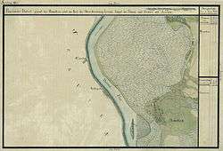
There is an impression of the old village which is recorded on the map of the Franciscan land survey from the early 19th century in the National Archives of Austria. In 1904, cadastral maps of the village were recorded which are located at the National Archives of Hungary.[8][9]
Culture
| Historical population | ||
|---|---|---|
| Year | Pop. | ±% |
| 1921 | 5,242 | — |
| 1931 | 5,172 | −1.3% |
| 1948 | 5,084 | −1.7% |
| 1953 | 5,026 | −1.1% |
| 1961 | 5,565 | +10.7% |
| 1971 | 5,693 | +2.3% |
| 1981 | 6,500 | +14.2% |
| 1991 | 6,782 | +4.3% |
| 2002 | 6,518 | −3.9% |
| 2011 | 6,309 | −3.2% |
| Source: [10][11][12] | ||
Since 1971, there is an annual amateur film festival named Žisel, paired with the photography festival two years later. The name is coined from ži(vot) sel(a), Serbian for "life of the village" as it is dedicated to the subject. In time, the festival gained regional and international recognition, attracting even authors from Australia and the United States. As of 2017 it is the longest running village film festival in Serbia and the only one dealing with the subject of the country life. Since 2010, there is a cultural association named Žisel in the village.[13][14][15]
References
- "Насеља општине Панчево" (pdf). stat.gov.rs (in Serbian). Statistical Office of Serbia. Retrieved 24 October 2019.
- "2011 Census of Population, Households and Dwellings in the Republic of Serbia: Comparative Overview of the Number of Population in 1948, 1953, 1961, 1971, 1981, 1991, 2002 and 2011, Data by settlements" (PDF). Statistical Office of Republic Of Serbia, Belgrade. 2014. ISBN 978-86-6161-109-4. Retrieved 2014-06-27.
- Official Website by Nature Park Ponjavica (in Serbian), Retrieved on 2017-01-08.
- History of the discovery of the water source Archived 2017-01-09 at the Wayback Machine on the Website by Krstarica vesti (in Serbian), Retrieved on 2017-01-08.
- Olga Janković (26 July 2017), "Od omoljičke banje ostade samo „lekovita rupa"", Politika (in Serbian)
- Omoljica on the Website of Srbiju volimo (in Serbian)
- Olga Janković (25 October 2018). "Kako je Vuk iz Omoljice krenuo u "Jevropu"" [How Vuk went to Europe from Omoljica]. Politika (in Serbian). p. 20.
- Omoljica (Homolic) on the map of the Franciscan land survey, Retrieved on 2017-01-12.
- Cadastre maps of Omoljica (Homolicz), Retrieved on 2017-01-12
- Final results of the census of population from 31 January 1921, page 354. Kingdom of Yugoslavia - General State Statistics, Sarajevo. June 1932.
- Final results of the census of population from 31 March 1931, page 54. Kingdom of Yugoslavia - General State Statistics, Belgrade. 1937.
- Comparative overview of the number of population in 1948, 1953, 1961, 1971, 1981, 1991, 2002 and 2011 – Data by settlements, page 29. Statistical Office of the Republic of Serbia, Belgrade. 2014. ISBN 978-86-6161-109-4.
- Olga Janković (6 August 2017), "Najdugovečniji seoski samit filma i fotografije", Politika (in Serbian), p. 14
- Festival Žisel 2017 on the Website of Pančevo online (in Serbian), Retrieved on 2017-09-05.
- Official Website by KUD Žisel (in Serbian), Retrieved on 2017-01-08.
| Wikimedia Commons has media related to Omoljica. |