Šid
Šid (Serbian Cyrillic: Шид, pronounced [ʃîːd]) is a town and municipality located in the Srem District of the autonomous province of Vojvodina, Serbia. It has a population of 14,893, while the municipality has 34,188 inhabitants.
Šid | |
|---|---|
Town and municipality | |
 _810.jpg) 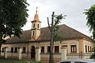  _Slov%C3%A1ci_v_%D0%A8%D0%B8%D0%B4%D1%83.jpg) From top: Russian palace, Church of the Assumption of the Most Holy Theotokos, Church building, Šid train station, Slovakian home in Šid | |
 Coat of arms | |
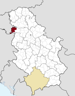 Location of the municipality of Šid within Serbia | |
| Coordinates: 45°07′N 19°14′E | |
| Country | |
| Province | |
| Region | Syrmia |
| District | Srem |
| Settlements | 19 |
| Government | |
| • Mayor | Predrag Vuković (SNS) |
| Area | |
| • Town | 47.30 km2 (18.26 sq mi) |
| • Municipality | 687.07 km2 (265.28 sq mi) |
| Elevation | 98 m (322 ft) |
| Population (2011 census)[2] | |
| • Town | 14,893 |
| • Town density | 310/km2 (820/sq mi) |
| • Municipality | 34,188 |
| • Municipality density | 50/km2 (130/sq mi) |
| Time zone | UTC+1 (CET) |
| • Summer (DST) | UTC+2 (CEST) |
| Postal code | 22240 |
| Area code | +381(0)22 |
| Car plates | ŠI |
| Website | www |
Name
In Serbian, the town is known as Šid (Шид), in Hungarian as Sid, in German as Schid, in Slovak as Šíd, and in Rusyn as Шид.
History
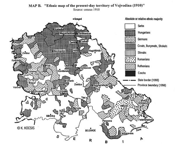
Šid was firstly mentioned in 1702. At first, settlement was part of Danubian Military Frontier, but since the middle of the 18th century, it was part of the Syrmia County of the Habsburg Kingdom of Slavonia. In 1848-1849, Šid was part of Serbian Vojvodina, and in 1849-1860 part of Voivodeship of Serbia and Banat of Temeschwar. After the abolishment of the voivodeship in 1860, Šid was again incorporated into Syrmia County of the Kingdom of Slavonia. In 1868, Kingdom of Slavonia was joined with the Kingdom of Croatia into the Kingdom of Croatia-Slavonia, which was part of the Kingdom of Hungary and Austria-Hungary. Šid was a district center within Syrmia County. In 1910, ethnic Serbs were in absolute majority in the town,[3][4] while other sizable ethnic groups included Rusyns, Slovaks and Croats.
In 1918, the town first became part of the State of Slovenes, Croats and Serbs, then part of the Kingdom of Serbia and finally part of the Kingdom of Serbs, Croats and Slovenes. From 1918 to 1922, Šid was part of the Syrmia county, from 1922 to 1929 part of the Syrmia oblast, from 1929 to 1931 part of the Drina Banovina, from 1931 to 1939 part of the Danube Banovina, and from 1939 to 1941 part of the Banovina of Croatia. During World War II, from 1941 to 1944, the town was occupied by Axis troops and was included into the Pavelić's Independent State of Croatia. The fascist Ustashe regime systematically murdered Serbs (as part of the Genocide of the Serbs), Jews (The Holocaust), Roma (The Porajmos), and some political dissidents. On August 1942, following the joint military anti-partisan operation in the Syrmia by the Ustashe and German Wehrmacht, it turned into a massacre by the Ustasha militia that left up to 7,000 Serbs dead.[5] Among those killed was the prominent painter Sava Šumanović, who was arrested along with 150 residents of Šid.[6] In 1944, Šid was liberated by Yugoslav Partisans and until April 1945, a number of battles of the Syrmian Front campaign were fought near the town. The Yugoslav Partisans mined the local Catholic church during the offensive in late 1944.[7] Since 1944, the town is part of Vojvodina, which (from 1945) was an autonomous province of Serbia and Yugoslavia.
On 5 November 1991, the Serbian government accused Croatian forces of firing 15 artillery rockets into the city, killing four people and wounding 12 in what became the first attack on Serbian soil during the Yugoslav Wars.[8][9] In 2009, Šid was declared mine-free after demining actions to remove explosives dating from the conflict.[10]
Inhabited places
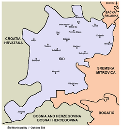
The municipality of Šid encompasses of town of Šid, and the following villages:
☢
Demographics
| Historical population | ||
|---|---|---|
| Year | Pop. | ±% p.a. |
| 1948 | 32,518 | — |
| 1953 | 34,679 | +1.30% |
| 1961 | 37,430 | +0.96% |
| 1971 | 38,752 | +0.35% |
| 1981 | 37,459 | −0.34% |
| 1991 | 36,317 | −0.31% |
| 2002 | 38,973 | +0.64% |
| 2011 | 34,188 | −1.44% |
| Source: [11] | ||
According to the 2011 census results, the municipality of Šid has 34,188 inhabitants.
Ethnic groups
Most of the settlements in the municipality have an ethnic Serb majority. The settlement with Slovak ethnic majority is Ljuba. Ethnically mixed settlements are Bikić Do (with relative Rusyn majority) and Sot (with relative Serb majority).
The ethnic composition of the municipality:[12]
| Ethnic group | Population | % |
|---|---|---|
| Serbs | 26,646 | 77.94% |
| Slovaks | 2,136 | 6.25% |
| Croats | 1,748 | 5.11% |
| Rusyns | 1,027 | 3.00% |
| Roma | 204 | 0.60% |
| Hungarians | 179 | 0.52% |
| Yugoslavs | 152 | 0.44% |
| Ukrainians | 47 | 0.14% |
| Macedonians | 26 | 0.08% |
| Montenegrins | 26 | 0.08% |
| Muslims | 24 | 0.07% |
| Russians | 17 | 0.05% |
| Germans | 14 | 0.04% |
| Albanians | 10 | 0.03% |
| Others | 1,932 | 5.65% |
| Total | 34,188 |
Culture
Near the Privina Glava village is Privina Glava Monastery. According to the legend, the monastery was founded by the squire Priva in the 12th century.
In Šid, there is a museum dedicated to an important Serbian artist Sava Šumanović, and a museum of naïve art "Ilijanum" consisting of more than 300 works of fine art, mainly paintings.
Economy
The following table gives a preview of total number of registered people employed in legal entities per their core activity (as of 2018):[13]
| Activity | Total |
|---|---|
| Agriculture, forestry and fishing | 644 |
| Mining and quarrying | - |
| Manufacturing | 1,760 |
| Electricity, gas, steam and air conditioning supply | 18 |
| Water supply; sewerage, waste management and remediation activities | 195 |
| Construction | 104 |
| Wholesale and retail trade, repair of motor vehicles and motorcycles | 1,043 |
| Transportation and storage | 588 |
| Accommodation and food services | 181 |
| Information and communication | 129 |
| Financial and insurance activities | 118 |
| Real estate activities | 4 |
| Professional, scientific and technical activities | 282 |
| Administrative and support service activities | 89 |
| Public administration and defense; compulsory social security | 858 |
| Education | 502 |
| Human health and social work activities | 369 |
| Arts, entertainment and recreation | 90 |
| Other service activities | 101 |
| Individual agricultural workers | 508 |
| Total | 7,593 |
Twin towns – sister cities
There are three official sister cities of Šid:
Notable people
- Milenko Atanacković
- Mira Banjac
- Ilija Bašičević Bosilj
- Dejan Bulatović
- Željko Fajfrić (b. 1957), Serbian academic, lawyer and historian
- Blagoje Jastrebić
- Vitomir Korać
- Herbert Kraus (1910-1970), Yugoslav partisan
- Georgije Magarašević
- Žarko Miladinović
- Bojan Milanović
- Grozdana Olujić
- Boško Simonović
- Sava Šumanović
- Branislav Ivanović
See also
- Syrmia District
- Syrmia
- Šid railway station
References
- "Municipalities of Serbia, 2006". Statistical Office of Serbia. Retrieved 2010-11-28.
- "2011 Census of Population, Households and Dwellings in the Republic of Serbia: Comparative Overview of the Number of Population in 1948, 1953, 1961, 1971, 1981, 1991, 2002 and 2011, Data by settlements" (PDF). Statistical Office of Republic Of Serbia, Belgrade. 2014. ISBN 978-86-6161-109-4. Retrieved 2014-06-27.
- "Archived copy". Archived from the original on 2011-10-07. Retrieved 2011-06-28.CS1 maint: archived copy as title (link)
- "Ethnic Map" (GIF). Americanhungarianfederation.org. Retrieved 2017-08-28.
- Korb, Alexander (2010c). "Integrated Warfare? The Germans and the Ustaša Massacres: Syrmia 1942". In Shepherd, Ben (ed.). War in a Twilight World: Partisan and Anti-Partisan Warfare in Eastern Europe, 1939–1945. Palgrave Macmillan. ISBN 978-0-230-29048-8.CS1 maint: ref=harv (link)
- Greif, Gideon (2018). Jasenovac - Auschwitz of the Balkans. Knjiga komerc. p. 437. ISBN 9789655727272.CS1 maint: ref=harv (link)
- "Obnova crkve Presvetog Srca Isusova u Šidu". Slobodnadalmacija.hr. Retrieved 2017-08-28.
- Serbs accused Croatia of second attack Reuters, 5 November 1991
- Mojsilovich, Julijana (5 November 1991). "Serbians claim fighting spills into Serbia for first time". Associated Press.
- razminiranje, HCR - Hrvatski centar za. "HCR - Hrvatski centar za razminiranje". Hcr.hr. Retrieved 2017-08-28.
- "2011 Census of Population, Households and Dwellings in the Republic of Serbia" (PDF). stat.gov.rs. Statistical Office of the Republic of Serbia. Archived from the original (PDF) on 14 July 2014. Retrieved 19 August 2017.
- "Population by ethnicity and sex, by municipalities and cities" (PDF). stat.gov.rs. Statistical Office of Serbia. Archived from the original (PDF) on 11 August 2014. Retrieved 19 August 2017.
- "MUNICIPALITIES AND REGIONS OF THE REPUBLIC OF SERBIA, 2019" (PDF). stat.gov.rs. Statistical Office of the Republic of Serbia. 25 December 2019. Retrieved 28 December 2019.
External links
| Wikimedia Commons has media related to Šid. |
- Official Site of Šid (in Serbian)
- Russian Castle (in Serbian)
- Šidski portal (in Serbian)
Šid Municipality | ||
|---|---|---|
| Settlements | | |
| History | ||
| Buildings and landmarks | ||
| Places of worship | ||
| Transport | ||
| Sport | ||

