Dimitrovgrad, Serbia
Dimitrovgrad (Serbian Cyrillic: Димитровград, Bulgarian: Цариброд, Tsaribrod) is a town and municipality located in the Pirot District of southeastern Serbia. According to 2011 census, the municipality of Dimitrovgrad has a population of 10,118 people and the town 6,278.
Dimitrovgrad Димитровград Tsaribrod | |
|---|---|
Town and municipality | |
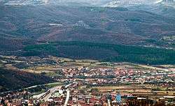 Panorama of Dimitrovgrad | |
.svg.png) Coat of arms | |
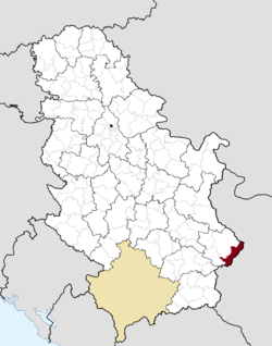 Location of the municipality of Dimitrovgrad within Serbia | |
| Coordinates: 43°01′N 22°47′E | |
| Country | |
| Region | Southern and Eastern Serbia |
| District | Pirot |
| Settlements | 43 |
| Government | |
| • Mayor | Vladica Dimitrov (SNS) |
| Area | |
| • Town | 17.15 km2 (6.62 sq mi) |
| • Municipality | 483 km2 (186 sq mi) |
| Elevation | 545 m (1,788 ft) |
| Population (2011 census)[3] | |
| • Town | 6,247 |
| • Town density | 360/km2 (940/sq mi) |
| • Municipality | 10,059 |
| • Municipality density | 21/km2 (54/sq mi) |
| Time zone | UTC+1 (CET) |
| • Summer (DST) | UTC+2 (CEST) |
| Postal code | 18320 |
| Area code | +381(0)10 |
| Car plates | PI |
| Website | www |
Name
Since 1950, the official name of the town has been Dimitrovgrad, but the name Caribrod is also used.[4] In Bulgarian, the name Tsaribrod (Цариброд) is preferred because there is another town called Dimitrovgrad on the Maritsa river in Bulgaria and Tsaribrod was used before the town was named after Georgi Dimitrov, a Bulgarian Communist leader who advocated a union between the Bulgarians and remaining Yugoslav nations to form the Balkan Federation.
The idea was abandoned when Yugoslav leader Josip Broz Tito failed to reach agreements with Joseph Stalin (Tito-Stalin split); however Dimitrov himself did not become unpopular in Yugoslavia from the breakdown and subsequently, the name of the town continued to be in honour of him despite many citizens themselves having preferred Caribrod.
There have been attempts to return the old name, Caribrod, but all had less than 50% turnout and most of them were in favor of keeping the name Dimitrovgrad.[4] In 2019, local government decided to add tables with name Caribrod on several municipality's objects in order to please the needs of people who like the former name.[4] In October municipal assembly decided to return the old name to the municipality. The document is sent to Ministry of Public Administration for further procedures.[5]
Geography
Climate
Dimitrovgrad has a humid subtropical climate (Köppen climate classification: Cfa), that's close to an oceanic climate (Köppen climate classification: Cfb).
| Climate data for Dimitrovgrad (1981–2010, extremes 1961–2010) | |||||||||||||
|---|---|---|---|---|---|---|---|---|---|---|---|---|---|
| Month | Jan | Feb | Mar | Apr | May | Jun | Jul | Aug | Sep | Oct | Nov | Dec | Year |
| Record high °C (°F) | 21.1 (70.0) |
24.0 (75.2) |
28.8 (83.8) |
32.4 (90.3) |
35.6 (96.1) |
39.2 (102.6) |
42.0 (107.6) |
40.2 (104.4) |
37.8 (100.0) |
33.4 (92.1) |
27.8 (82.0) |
21.8 (71.2) |
42.0 (107.6) |
| Average high °C (°F) | 5.0 (41.0) |
7.2 (45.0) |
12.6 (54.7) |
18.0 (64.4) |
23.3 (73.9) |
27.1 (80.8) |
29.6 (85.3) |
29.1 (84.4) |
25.6 (78.1) |
18.7 (65.7) |
12.0 (53.6) |
6.0 (42.8) |
18.6 (65.5) |
| Daily mean °C (°F) | 0.6 (33.1) |
2.0 (35.6) |
7.0 (44.6) |
12.0 (53.6) |
16.6 (61.9) |
20.1 (68.2) |
22.2 (72.0) |
21.0 (69.8) |
17.3 (63.1) |
12.1 (53.8) |
6.2 (43.2) |
1.8 (35.2) |
12.7 (54.9) |
| Average low °C (°F) | −2.3 (27.9) |
−0.6 (30.9) |
3.8 (38.8) |
6.6 (43.9) |
12.5 (54.5) |
14.6 (58.3) |
17.0 (62.6) |
15.9 (60.6) |
13.2 (55.8) |
7.6 (45.7) |
2.7 (36.9) |
−1.0 (30.2) |
6.6 (43.9) |
| Record low °C (°F) | −21.3 (−6.3) |
−16.5 (2.3) |
−10.8 (12.6) |
−7.2 (19.0) |
0.3 (32.5) |
2.5 (36.5) |
5.6 (42.1) |
4.8 (40.6) |
1.5 (34.7) |
−5.9 (21.4) |
−11.0 (12.2) |
−17.3 (0.9) |
−21.3 (−6.3) |
| Average precipitation mm (inches) | 39.5 (1.56) |
38.1 (1.50) |
40.2 (1.58) |
54.3 (2.14) |
67.2 (2.65) |
70.0 (2.76) |
61.1 (2.41) |
52.5 (2.07) |
51.8 (2.04) |
50.2 (1.98) |
52.8 (2.08) |
46.9 (1.85) |
624.7 (24.59) |
| Average precipitation days (≥ 0.1 mm) | 12 | 12 | 12 | 14 | 13 | 12 | 9 | 8 | 9 | 9 | 11 | 13 | 112 |
| Average snowy days | 7 | 4 | 1 | 0 | 0 | 0 | 0 | 0 | 0 | 0 | 2 | 6 | 20 |
| Average relative humidity (%) | 81 | 77 | 70 | 67 | 69 | 70 | 66 | 66 | 71 | 75 | 79 | 82 | 73 |
| Mean monthly sunshine hours | 91.4 | 119.1 | 158.1 | 176.5 | 240.1 | 278.6 | 312.3 | 299.9 | 242.1 | 177.9 | 124.8 | 84.5 | 2,305.3 |
| Source: Republic Hydrometeorological Service of Serbia[6] | |||||||||||||
History
The Roman road Via Militaris was built in the 1st century AD and went through the town. In May 2010, well-preserved remains of the road were excavated during the work on Corridor 10.[7]
An Ottoman military base operated in the west of Dimitrovgrad prior to the Balkan nations full independence.[8]
During the Serbo-Bulgarian War, two battles were fought here, the 1st Battle of Caribrod and the 2nd Battle of Caribrod.
The Serbian and Bulgarian Prime ministers met at the then Tsaribrod in 1912 to discuss the disputed territories in Macedonia.[9] The Kingdom of Serbs, Croats and Slovenes gained parts of the Principality of Bulgaria (known in Bulgaria as Western Outlands) which included Tsaribrod following the Treaty of Neuilly, signed on November 27, 1919.
From 1929 to 1941, Caribrod was part of the Morava Banovina of the Kingdom of Yugoslavia. It was occupied by Kingdom of Bulgaria between 1941 and 1944 during World War II.
Demographics
| Historical population | ||
|---|---|---|
| Year | Pop. | ±% p.a. |
| 1948 | 23,063 | — |
| 1953 | 22,082 | −0.87% |
| 1961 | 18,418 | −2.24% |
| 1971 | 16,365 | −1.17% |
| 1981 | 15,158 | −0.76% |
| 1991 | 13,488 | −1.16% |
| 2002 | 11,748 | −1.25% |
| 2011 | 10,118 | −1.65% |
| Source: [10] | ||
According to the 2011 census results, the municipality has 10,118 inhabitants.
Ethnic groups
Regardless of ethnic self-identification, most of the town's population speaks a South Slavic dialect usually called Torlak which includes linguistic features of both Serbian (especially phonology) and Bulgarian (postposed definite articles and lack of the infinitive verb form), as well as some entirely unique vocabulary.
Ethnic composition of the municipality:
| Ethnic group | Population | % |
|---|---|---|
| Bulgarians | 5,413 | 53.50% |
| Serbs | 2,819 | 27.86% |
| Romani | 68 | 0.67% |
| Yugoslavs | 59 | 0.58% |
| Macedonians | 38 | 0.38% |
| Croats | 16 | 0.16% |
| Others | 1,705 | 16.85% |
| Total | 10,118 |
Economy
The following table gives a preview of total number of registered people employed in legal entities per their core activity (as of 2018):[11]
| Activity | Total |
|---|---|
| Agriculture, forestry and fishing | 7 |
| Mining and quarrying | 5 |
| Manufacturing | 514 |
| Electricity, gas, steam and air conditioning supply | 19 |
| Water supply; sewerage, waste management and remediation activities | 182 |
| Construction | 114 |
| Wholesale and retail trade, repair of motor vehicles and motorcycles | 250 |
| Transportation and storage | 238 |
| Accommodation and food services | 228 |
| Information and communication | 19 |
| Financial and insurance activities | 15 |
| Real estate activities | - |
| Professional, scientific and technical activities | 58 |
| Administrative and support service activities | 45 |
| Public administration and defense; compulsory social security | 437 |
| Education | 123 |
| Human health and social work activities | 174 |
| Arts, entertainment and recreation | 52 |
| Other service activities | 71 |
| Individual agricultural workers | 41 |
| Total | 2,594 |
Gallery
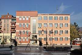 Dimitrovgrad Town Hall
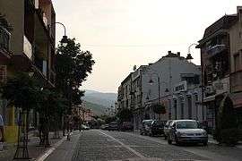 Town center
 The cultural center on the main square
See also
References
- "Municipalities of Serbia, 2006". Statistical Office of Serbia. Retrieved 2010-11-28.
- "Насеља општине Димитровград" (pdf). stat.gov.rs (in Serbian). Statistical Office of Serbia. Retrieved 24 October 2019.
- "2011 Census of Population, Households and Dwellings in the Republic of Serbia: Comparative Overview of the Number of Population in 1948, 1953, 1961, 1971, 1981, 1991, 2002 and 2011, Data by settlements" (PDF). Statistical Office of Republic Of Serbia, Belgrade. 2014. ISBN 978-86-6161-109-4. Retrieved 2014-06-27.
- Jovićič, Branislav (18 February 2019). "I Dimitrovgrad i Caribrod". rts.rs (in Serbian). Retrieved 16 June 2019.
- "Dimitrovgrad to return the old name - Caribrod". 021.
- "Monthly and annual means, maximum and minimum values of meteorological elements for the period 1967–2017" (in Serbian). Republic Hydrometeorological Service of Serbia. Retrieved February 25, 2017.
- https://www.blic.rs/kultura/vesti/otkriveni-ostaci-antickog-puta-via-militaris-na-koridoru-10/lmeh4z6
- A Military Geography of the Balkan Peninsula at Google Books
- The Ottoman Empire and Its Successors, 1801–1927 at Google Books
- "2011 Census of Population, Households and Dwellings in the Republic of Serbia" (PDF). stat.gov.rs. Statistical Office of the Republic of Serbia. Archived from the original (PDF) on 14 July 2014. Retrieved 6 March 2017.
- "MUNICIPALITIES AND REGIONS OF THE REPUBLIC OF SERBIA, 2019" (PDF). stat.gov.rs. Statistical Office of the Republic of Serbia. 25 December 2019. Retrieved 28 December 2019.
External links
| Wikimedia Commons has media related to Dimitrovgrad, Serbia. |