Srbobran
Srbobran (Serbian: Србобран, IPA: [sr̩̂bɔbraːn], Hungarian: Szenttamás[4]) is a town and municipality located in the South Bačka District of the autonomous province of Vojvodina, Serbia. The town is located on the north bank of the Danube-Tisa-Danube canal. The town has a population of 12,009, and the municipality of 16,317.
Srbobran | |
|---|---|
Town and municipality | |
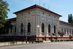 Historic City Hall | |
 Coat of arms | |
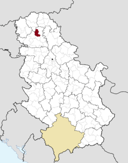 Location of the municipality of Srbobran within Serbia | |
| Coordinates: 45°32′N 19°47′E | |
| Country | |
| Province | Vojvodina |
| District | South Bačka |
| Settlements | 3 |
| Government | |
| • Mayor | Radivoj Paroški[1] |
| Area | |
| • Municipality | 284 km2 (110 sq mi) |
| Elevation | 82 m (269 ft) |
| Population (2011 census)[3] | |
| • Town | 12,009 |
| • Municipality | 16,317 |
| Time zone | UTC+1 (CET) |
| • Summer (DST) | UTC+2 (CEST) |
| Postal code | 21480 |
| Area code | +381 21 |
| Car plates | NS |
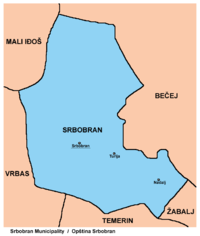
The municipality of Srbobran encompasses of town of Srbobran, and two villages: Nadalj and Turija.
Name
In Serbian, the town is known as Srbobran (Србобран); in Hungarian as Szenttamás (pronounced [ˈsɛntɒmaːʃ]) or Szrbobran (formerly also Bács-Szenttamás); in Rusyn (a Cyrillic-only language) as /Србобран/; in Croatian as Sveti Tomo, Senttomaš or Srbobran; in Slovak as Srbobran; and in German as Thomasberg or Sankt Thomas. The name Srbobran means "Serbs' defender" in Serbian. Older Serbian name used for the town was Sentomaš (Сентомаш).[5]
History
According to archaeology, there was human settlement in the territory of present-day Srbobran in the prehistoric times. The first written record about the settlement is from 1338, in which the Srbobran is mentioned under name Sentomas, which means Saint Thomas, i.e. the apostle Thomas, who was the patron saint of a monastery and of the village around it in the Middle Ages. During this time, the area was under administration of the medieval Kingdom of Hungary and was part of the Bacsensis County. This village, together with the monastery, became destroyed during the Ottoman conquest in the 16th century. Its former population left the region and fled towards North to Habsburg Royal Hungary. During the Ottoman administration, the settlement of Sentomaš was rebuilt and was populated by ethnic Serbs. It was part of the Ottoman Sanjak of Segedin.
After the Bačka region was captured by Habsburg troops led by Prince Eugene of Savoy in the end of the 17th century, a settlement was included into Habsburg Monarchy and was populated by new colonists, mainly by ethnic Serbs from the South, but also (since the second half of the 18th century) by ethnic Hungarians from the North, who became the second largest ethnic group in the settlement (after Serbs). The settlement was part of the Military Frontier until 1751, when it came under the civil administration. A document from 1751 indicates that besides name Sentomaš, the name Srbograd (Serb Town) was also used as a non-official denomination for the town. The development of the town was fast; in 1787 its population was 3,532, while in 1836 this number rose to 11,321. From 1751, the town was part of the Theiss District within the Batsch-Bodrog County and the Habsburg Kingdom of Hungary.
The name Srbobran dates from the time of 1848/1849 revolutions in the Habsburg Monarchy, but was officially used since 1918. In 1848-1849, the town was part of Serbian Voivodship, a Serbian autonomous region within the Austrian Empire. The Serbian defense line was located near this town, hence the name Srbobran, which means "Serbs's defender". On July 14, 1848, the first siege of the town by Hungarian forces began under Baron Fülöp Berchtold who was forced to retreat due to a strong Serbian defense. The Hungarian troops captured Sentomaš for the fourth trial, on April 4, 1849, and burned the town to the ground. Having suppressed the Hungarian anti-Habsburg movement (in 1849), Austrian authorities established a new province to which Sentomaš belonged to: the Voivodeship of Serbia and Banat of Temeschwar, which existed until 1860. In 1850, the population of Sentomaš was 5,630 people, which was only about half of the population recorded in 1836. After abolishment of the voivodeship in 1860, Sentomaš was again included into the Batsch-Bodrog County. Since the establishment of the dual Monarchy of Austria-Hungary in 1867, the town was located within the Hungarian part of the Monarchy. According to the official census of 1910, Sentomaš had 14,335 inhabitants, among them 7,808 (54.47%) spoke Serbian language, 6,031 (42.07%) spoke Hungarian language, and 430 (3%) spoke German language.
Sentomaš became part of the Kingdom of Serbs, Croats and Slovenes (which is called Yugoslavia since 1929) in 1918 and was officially named Srbobran. In 1918-1919, the town was part of the Banat, Bačka and Baranja region and also (between 1918 and 1922) part of the Novi Sad County. Between 1922 and 1929 it was part of Belgrade Oblast, and between 1929 and 1941 part of Danube Banovina. In 1941, the town was occupied by the Axis Powers and was attached to the Horthy's Hungary. In 1944, the Soviet Red Army and Yugoslav partisans expelled Axis troops from the region, at this time approximately 2000 civil people with Hungarian nationality was killed by revenge.[6] Srbobran was included into the autonomous province of Vojvodina within new socialist Yugoslavia. Since 1945, Vojvodina is part of the People's Republic of Serbia within Yugoslavia. Until the 1950s, Srbobran was part of the Bečej municipality, but then separate municipality of Srbobran was established. During the Yugoslav wars of the 1990s, some Serb refugees came from Croatia, Bosnia and Herzegovina, and Kosovo, and settled in Srbobran.
Demographics

Ethnic groups in the municipality
According to the 2011 census, the population of the Srbobran municipality is composed of:[7]
- Serbs = 10,703 (65.63%)
- Hungarians = 3,387 (20.76%)
- Romani = 629 (3.85%)
- Others and undeclared = 1,598 (9.79%)
All of the three settlements in the municipality have an ethnic Serb majority. The Serbian and Hungarian language are officially used by municipal authorities.[8]
Also see: Serbs in Vojvodina, Hungarians in Vojvodina, Romani people of Vojvodina.
Ethnic groups in the town
In 2011, Srbobran town has a population of 12,009, including:[7]
- Serbs = 7,093 (59.06%)
- Hungarians = 3,220 (26.81%)
- Roma = 465 (3.87%)
- Others and undeclared = 1,231 (10.25%)
Historical population of the town
- 1961: 14,391
- 1971: 14,189
- 1981: 13,596
- 1991: 12,798
- 2011: 11,968
Economy
The following table gives a preview of total number of employed people per their core activity (as of 2017):[9]
| Activity | Total |
|---|---|
| Agriculture, forestry and fishing | 427 |
| Mining | 18 |
| Processing industry | 459 |
| Distribution of power, gas and water | 61 |
| Distribution of water and water waste management | 48 |
| Construction | 106 |
| Wholesale and retail, repair | 465 |
| Traffic, storage and communication | 135 |
| Hotels and restaurants | 77 |
| Media and telecommunications | 12 |
| Finance and insurance | 20 |
| Property stock and charter | 2 |
| Professional, scientific, innovative and technical activities | 89 |
| Administrative and other services | 43 |
| Administration and social assurance | 176 |
| Education | 190 |
| Healthcare and social work | 176 |
| Art, leisure and recreation | 23 |
| Other services | 77 |
| Total | 2,604 |
Transport
Town is located near to the M22 motorway between Belgrade and Subotica. There are two national highways that run through the town, highways 3 and 22. These three important routes make the town an important transport link.
Highway 3 runs west to Sombor, and east to Bečej. Highway 22 runs to Budapest in Hungary to the north changing to Highway 5 in Hungary, and to Ribarice, in the south of Serbia.
Architecture
There are two notable buildings in Srbobran, both of which are churches (one is Serb Orthodox, the other one is Roman Catholic) and both are built in highly sophisticated late baroque style.
Famous citizens
- Members of the wealthy Dunđerski family were buried in the town's cemetery, including the famous beauty Lenka Dunđerski, who was a tragic love of poet Laza Kostić.
- Srbobran is the birthplace of Nándor Gion (1941–2002), one of the best-known Hungarian writers, who was born and mostly lived in the region of Vojvodina. In his books he describes, first of all, his home-town, "Szenttamás", during the tragic years of the world wars.
- Đorđe Dunđerski, Yugoslavian tennis player
- Serbian poet Vladislav Kaćanski was born in Srbobran.
- Ognjen Mudrinski, football player
- Aleksandar Katai, footballer, member of the Serbia national football team
Gallery
 Oil drilling facilities near Srbobran
 Catholic Church
See also
- List of places in Serbia
- List of cities, towns and villages in Vojvodina
- Municipalities of Serbia
- South Bačka District
Notes and references
- Notes
- Slobodan Ćurčić, Broj stanovnika Vojvodine, Novi Sad, 1996.
- Slobodan Ćurčić, Naselja Bačke - geografske karakteristike, Novi Sad, 2007.
- References
- "Председник општине Србобран РАДИВОЈ ПАРОШКИ". Srbobran Official website. Retrieved 3 April 2018.
- "Municipalities of Serbia, 2006". Statistical Office of Serbia. Retrieved 2010-11-28.
- "2011 Census of Population, Households and Dwellings in the Republic of Serbia: Comparative Overview of the Number of Population in 1948, 1953, 1961, 1971, 1981, 1991, 2002 and 2011, Data by settlements" (PDF). Statistical Office of Republic Of Serbia, Belgrade. 2014. ISBN 978-86-6161-109-4. Retrieved 2014-06-27.
- Општина Србобран: Локална самоуправа (in Serbian). Municipality of Srbobran. Retrieved 2013-02-06.
On the territory of the Municipality in official use are Serbian language and Cyrillic script and Hungarian language and script
- "Srbobran Map and Weather Forecast". Worldplaces.net. Retrieved 2017-08-28.
- "CSERES TIBOR: VÉRBOSSZÚ BÁCSKÁBAN". Vmek.oszk.hu. Retrieved 2017-08-28.
- "Population by ethnicity – Srbobran". Statistical Office of the Republic of Serbia (SORS). Retrieved 4 March 2013.
- "Statut opštine Srbobran" (PDF), Ombudsman.rs (in Serbian), p. 1, 8 July 2008
- "ОПШТИНЕ И РЕГИОНИ У РЕПУБЛИЦИ СРБИЈИ, 2018" (PDF). stat.gov.rs (in Serbian). Statistical Office of the Republic of Serbia. Retrieved 17 March 2019.
External links
| Wikimedia Commons has media related to Srbobran. |


| Authority control |
|
|---|