Savski Venac
Savski Venac (Serbian Cyrillic: Савски Венац, pronounced [sâːv̞skiː v̞ě̞ːnat͡s]) is a municipality of the city of Belgrade. According to the 2011 census results, the municipality has a population of 39,122 inhabitants.
Savski Venac Савски Венац | |
|---|---|
.png) Coat of arms | |
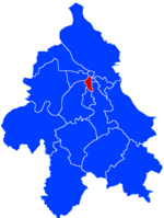 Location of Savski Venac within the city of Belgrade | |
| Coordinates: 44°41′N 20°24′E | |
| Country | |
| City | |
| Status | Municipality |
| Settlements | 1 |
| Government | |
| • Type | Municipality of Belgrade |
| • Mun. president | Irena Vujović (SNS) |
| Area | |
| • Total | 14.07 km2 (5.43 sq mi) |
| Population (2011) | |
| • Total | 39,122 |
| • Density | 2,800/km2 (7,200/sq mi) |
| Time zone | UTC+1 (CET) |
| • Summer (DST) | UTC+2 (CEST) |
| Postal code | 11000 |
| Area code(s) | +381(0)11 |
| Car plates | BG |
| Website | www.savskivenac.rs |
It is one of the three municipalities which constitute the very center of Belgrade, together with Stari Grad and Vračar.[2]
Savski Venac is located on the right bank of the Sava river. It stretches in the north-south direction for 6 kilometers (3.7 mi) (from downtown Belgrade, just 200 meters (660 ft) from Terazije, to Banjica) and east-west direction for 3 kilometers (1.9 mi) (from Senjak and the Sava bank to Autokomanda). It borders the municipalities of Stari Grad to the north, Vračar to the north-east, Voždovac to the east, Rakovica to the south and Čukarica to the west.
History and name
While Savski Venac and Stari Grad are often styled the oldest municipalities of Belgrade due to their inclusion of the oldest sections of urban Belgrade outside the walls of the Kalemegdan fortress, they are actually the most recently created municipalities of Belgrade. Both were formed in 1957 by merger of older, smaller municipalities; Savski Venac was formed in by merger of the municipalities of Zapadni Vračar (its main predecessor) and Topčidersko Brdo and a new, geographical name, Savski Venac, was coined for it.
(Venac is usually used in Belgrade's geography in term of a round street (Obilićev Venac, Kosančićev Venac) or a rim of the river (Dunavski Venac). In this case it was the "rim of the Sava".)
Geography
With an area of 14 square kilometers (5.4 sq mi), Savski Venac is the third smallest municipality of Belgrade after Vračar and Stari Grad. Despite being small in area, it includes several diverse geographical features:
- the low section on the right bank of the Sava river (Savamala and Bara Venecija). Due to its low altitude toward the Sava, and lack of any protection, this is the only part of central urban area of Belgrade that gets flooded during the extremely high waters of the river. It was almost completely flooded in 1984 and during major floods in 2006.
- southern slopes of the hill of Terazije (Terazijska Terasa) which descends from downtown Belgrade to the Sava.
- entire western slope of the Vračar Hill (Karađorđev Park and former Zapadni Vračar) which also descends to the Sava.
- southern slope of the Vračar Hill, known as the Guberevac Hill or Ludo Brdo ("Crazy Hill") as it is the location of the psychiatric hospital "Laza Lazarević".[3]
- the former valley of the stream od Mokroluški Potok, now conducted underground. It is a route to the modern highway and the new railstation of Prokop.
- the hill of Topčidersko Brdo which has a cliff-like edge above the Sava (Senjak).
- the hill of Banjica in the extreme south of the municipality.
- the upper valley of Topčiderska reka and the vast park-forest of Topčider.
Neighborhoods
|
|
|
Demographics
| Historical population | ||
|---|---|---|
| Year | Pop. | ±% p.a. |
| 1948 | 54,067 | — |
| 1953 | 65,366 | +3.87% |
| 1961 | 74,971 | +1.73% |
| 1971 | 63,531 | −1.64% |
| 1981 | 53,374 | −1.73% |
| 1991 | 47,682 | −1.12% |
| 2002 | 42,505 | −1.04% |
| 2011 | 39,122 | −0.92% |
| Source: [4] | ||
According to the census of 2011, Savski Venac has a population of 39,122 inhabitants. As all the other central city municipalities, it has been depopulating for decades, however, it still remains one of the most densely populated: 2,445/km2 (6,330/sq mi) (4,686/km² or 12,136/sq mi back in 1961).
Ethnic structure
The ethnic composition of the municipality:[5]
| Ethnic group | Population |
|---|---|
| Serbs | 34,742 |
| Yugoslavs | 394 |
| Montenegrins | 369 |
| Croats | 251 |
| Romani | 237 |
| Macedonians | 191 |
| Muslims | 68 |
| Slovenians | 58 |
| Hungarians | 49 |
| Russians | 44 |
| Bosniaks | 38 |
| Slovaks | 33 |
| Romanians | 29 |
| Bulgarians | 27 |
| Albanians | 23 |
| Germans | 21 |
| Others | 2,548 |
| Total | 39,122 |
Administration
Recent Presidents of the municipality (since 2000):
- 2000–2004: Branislav Belić
- 2004–2012: Tomislav Đorđević
- 2012–2016: Dušan Dinčić
- 2016–present: Irena Vujović
Economy
The following table gives a preview of total number of registered people employed in legal entities per their core activity (as of 2018):[6]
| Activity | Total |
|---|---|
| Agriculture, forestry and fishing | 115 |
| Mining and quarrying | 21 |
| Manufacturing | 2,139 |
| Electricity, gas, steam and air conditioning supply | 105 |
| Water supply; sewerage, waste management and remediation activities | 283 |
| Construction | 2,268 |
| Wholesale and retail trade, repair of motor vehicles and motorcycles | 4,759 |
| Transportation and storage | 4,099 |
| Accommodation and food services | 2,204 |
| Information and communication | 3,801 |
| Financial and insurance activities | 2,431 |
| Real estate activities | 262 |
| Professional, scientific and technical activities | 4,729 |
| Administrative and support service activities | 5,919 |
| Public administration and defense; compulsory social security | 43,170 |
| Education | 4,407 |
| Human health and social work activities | 19,448 |
| Arts, entertainment and recreation | 1,184 |
| Other service activities | 1,069 |
| Individual agricultural workers | 8 |
| Total | 104,424 |
Sport
Sportsko Selo ("Sport Village") – In the early 1970s a football pitch was built at the end of the Deligradska street, right above the highway. It was adapted into the Yugoslav People's Army Reserve Officers' Training Ground, but in the early 1990s the location was abandoned. The lot was left unattended and gradually turned into a rubbish dump. In 2009 a project for the ground was jointly drafted by the city and the municipality with the working title "Ada Ciganlija u malom". After two years of construction, the new complex was opened on 30 May 2011. It covers an area of 85 ares (91,000 square feet) and contains one volleyball, three basketball and four tennis courts, children playgrounds and a fitness plateau. There are also a futsal and bocce courts, outdoor gym, walking paths, rest areas, wooden ice-cream kiosk and a parking lot. The complex is situated in a wooded area and includes an amphitheater suitable for the theatrical performances in the open. Invited to choose the name for the complex between the originally proposed "Ada Ciganlija u malom" and "Sportsko Selo" which appeared during the construction, citizens picked the latter.[7][8]
Features
Savski Venac constitutes the western section of the downtown Belgrade. Most government offices and administrative buildings are located in the municipality, including:
Administration
- The Government of the Republic of Serbia in Nemanjina Street
- The building of the ministries, also in Nemanjina street
- The new building of the National Bank of Serbia, (Slavija)
- The former buildings of republic and federal police (destroyed during the 1999 NATO's attack)
- The former complex of the Joint Chiefs of Staff (same as the above)
- Over 30 embassies and dozens of ambassadorial residences
- Archives of Yugoslavia (Senjak)
Traffic
Savski venac railway map | |||||||||||||||||||||||||||||||||||||||||||||||||||||||||||||||
|---|---|---|---|---|---|---|---|---|---|---|---|---|---|---|---|---|---|---|---|---|---|---|---|---|---|---|---|---|---|---|---|---|---|---|---|---|---|---|---|---|---|---|---|---|---|---|---|---|---|---|---|---|---|---|---|---|---|---|---|---|---|---|---|
| |||||||||||||||||||||||||||||||||||||||||||||||||||||||||||||||
- Belgrade Main railway station (Savski trg)
- Main bus station of Belgrade (BAS)
- Main bus station of Lasta (Bara Venecija)
- Belgrade Centre railway station (Prokop)
- The Belgrade-Niš highway and all the six bridges across the Sava to Novi Beograd: Brankov, Stari savski, Gazela, Stari želenički, Novi železnički, Most na Adi
- Both major interchanges in old Belgrade: Mostarska Petlja and Autokomanda
Economy and tourism
- BIP Brewery
- Belgrade Fair (Beogradski sajam, on the bank of the Sava)
- Open green market "Zeleni Venac"
- Hotel "Astorija"
- Hotel "Beograd"
- Hotel Bristol
- Beli Dvor, former royal court
Health
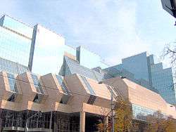
- Clinical Centre of Serbia, with 24 clinics and hospitals (beginning at Karađorđev park); two skyscrapers, which were to become one single Clinical Centre, a joint location for all the existing separate clinics, was planned, but by 1987 only one building was constructed, and only the lower floors became operational. Remainder of the building was left unfinished and left to the elements since. In March 2019, the Health ministry announced that the renovation of the operational part, revitalization of the empty building and construction of the twin tower, will all be finished by 2022.[9]
- City ambulance (Mostar)
- Hospital Dragiša Mišović (Dedinje)
- Železnička hospital (Dedinje)
- Orthopaedic hospital (Banjica)
- Vojnomedicinska akademija ("VMA", Banjica)
Culture and education
- Yugoslav Drama Theatre
- Theater Bojan Stupica
- Student's Cultural Center (SKC)
- University of Belgrade Faculty of Economics
- Faculty of the veterinarian medicine of the Belgrade University
- Touristic high school (Jug Bogdanova street)
- French School (Ecole Française de Belgrade)
Forests and parks
Urban forests and parks include:[10]
- Bencion Buli Forest (1.96 ha (4.8 acres))
- Banjica Rise Forest (3.61 ha (8.9 acres))
- Park Bristol
- Čukarica Bay Forest (3.61 ha (8.9 acres))
- Park Gavrilo Princip
- Grafičar Forest (3.89 ha (9.6 acres))
- Hajd Park (8.28 ha (20.5 acres))
- Lisičji Potok Forest (7.44 ha (18.4 acres))
- Park Luka Ćelović
- Park Manjež
- Park Milutin Milanković
- Reiss Slope Forest (3.46 ha (8.5 acres))
- Topčider Forest, with the entire complex around the Konak of Prince Miloš (16.25 ha (40.2 acres))
- Topčidersko Brdo Forest (21.22 ha (52.4 acres))
See also
- Subdivisions of Belgrade
- List of Belgrade neighborhoods and suburbs
References
- "Насеља општине Савски Венац" (pdf). stat.gov.rs (in Serbian). Statistical Office of Serbia. Retrieved 23 October 2019.
- Savski Venac - Official Profile in English
- Marija Brakočević (21 May 2014). "Beograd leži na 23 brda" [Belgrade lays on 23 hills]. Politika (in Serbian).
- "2011 Census of Population, Households and Dwellings in the Republic of Serbia" (PDF). stat.gov.rs. Statistical Office of the Republic of Serbia. Retrieved 25 February 2017.
- "ETHNICITY Data by municipalities and cities" (PDF). stat.gov.rs. Statistical Office of Serbia. Retrieved 1 March 2018.
- "MUNICIPALITIES AND REGIONS OF THE REPUBLIC OF SERBIA, 2019" (PDF). stat.gov.rs. Statistical Office of the Republic of Serbia. 25 December 2019. Retrieved 29 December 2019.
- "Sportski tereni umesto deponije", Politika (in Serbian), 18 May 2011
- M.S.M. (31 May 2011), "Od deponije - sportska oaza", Politika (in Serbian)
- Danijela Davidov Kesar (8 March 2019). "На лечење у обновљени КЦС тек 2022. године" [Treatments in the renovated CCS only in 2022]. Politika (in Serbian). p. 8.
- Anica Teofilović, Vesna Isajlović, Milica Grozdanić (2010). Пројекат "Зелена регулатива Београда" - IV фаза: План генералне регулације система зелених површина Београда (концепт плана) [Project "Green regulations of Belgrade" - IV phase: Plan of the general regulation of the green area system in Belgrade (concept of the plan)]. Urbanistički zavod Beograda.CS1 maint: multiple names: authors list (link)
External links
![]()