Southern and Eastern Serbia
The Southern and Eastern Serbia (Serbian: Јужна и источна Србија, romanized: Južna i istočna Srbija) is one of five statistical regions of Serbia. It is also a level-2 statistical region according to the European NUTS. It was formed in 2010. The region has a total population of 1,563,916, according to the 2011 census.
Southern and Eastern Serbia Јужна и источна Србија Južna i istočna Srbija | |
|---|---|
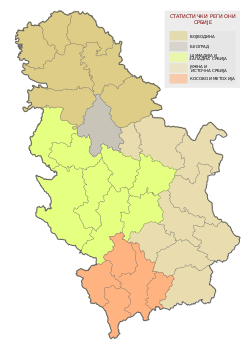 Location of Southern and Eastern Serbia in Serbia | |
| Country | |
| Founded | May 2010 |
| Largest city | Niš |
| Area | |
| • Total | 26,245 km2 (10,133 sq mi) |
| Area rank | 2nd |
| Population (2018) | |
| • Total | |
| • Rank | 4th (excl. Kosovo) |
| Nationality (2011) | |
| • Serbs | 89.11% |
| • Romani | 3.66% |
| • Vlachs | 2.1% |
| • Bulgarians | 0.99% |
| • Others | 4.14% |
| Districts | 9 |
| Settlements | 1,973 |
Formation
In July 2009, the Serbian parliament adopted a law which divided Serbia into seven statistical regions.[2] At first, it was decided that in the territory of current statistical region of Southern and Eastern Serbia there would be two statistical regions – Eastern Region (Serbian: Источни регион, romanized: Istočni region) and Southern Region (Serbian: Јужни регион, romanized: Južni region). However, in May 2010, the law was changed, thus the Eastern and Southern region were merged into a single statistical region named Southern and Eastern Serbia.
Districts
The statistical region of Southern and Eastern Serbia is composed of 9 administrative districts:
| District | Area (km²) | Population (2011 Census) |
Administrative Capital | |
|---|---|---|---|---|
| Podunavlje | 1,250 | 199,395 | Smederevo | |
| Braničevo | 3,865 | 183,625 | Požarevac | |
| Bor | 3,510 | 124,992 | Bor | |
| Zaječar | 3,623 | 119,967 | Zaječar | |
| Nišava | 2,727 | 376,319 | Niš | |
| Pirot | 2,761 | 92,479 | Pirot | |
| Toplica | 2,229 | 91,754 | Prokuplje | |
| Jablanica | 2,770 | 216,304 | Leskovac | |
| Pčinja | 3,520 | 159,081 | Vranje | |
Economy
Southern and Eastern Serbia region is the poorest in the country. Only Niš and Požarevac have GDP above the national average. The devastated areas include Babušnica, Bela Palanka, Bojnik, Bosilegrad, Vladičin Han, Golubac, Žagubica, Kuršumlija, Kučevo, Lebane, Medveđa, Svrljig, Surdulica, Trgovište and Crna Trava.[3]

The GDP of the region in 2017 was €6,640,000,000, or 13.8% of Serbia's GDP. The GDP per capita is €4,249.[4]
Cities and towns
The largest cities and towns of the region are:
| City or town | Population
of city proper |
Municipal population
(2011 Census) |
|---|---|---|
| Niš | 187,544 | 260,237 |
| Smederevo | 64,175 | 108,209 |
| Leskovac | 60,288 | 144,206 |
| Vranje | 55,138 | 83,524 |
| Požarevac | 44,183 | 75,334 |
| Pirot | 38,785 | 57,928 |
| Zaječar | 38,165 | 59,461 |
| Bor | 34,160 | 48,615 |
| Prokuplje | 27,333 | 44,419 |
| Smederevska Palanka | 23,601 | 50,284 |
| Aleksinac | 16,685 | 51,863 |
| Velika Plana | 16,088 | 40,902 |

Demographics
According to the 2011 census, the population of Southern and Eastern Serbia is 1,563,916. The most populated city is Niš with around 260,000 people in metro area. Other urban centers are Smederevo, Leskovac, Zajecar and Vranje with more than 50,000 people living in city proper area. The region is heavily affected by depopulation. Most critical situation is in municipalities of Gadžin Han, Crna Trava, Ražanj, Trgovište, as well as Bulgarian populated Dimitrovgrad and Bosilegrad. The good example of depopulation is Crna Trava that had 13,614 people in 1948, while in 2011 only 1,663 people were recorded.[6]
Albanians boycotted the 2011 census. It's estimated that 50,000 Albanians live in the municipalities of Preševo, Bujanovac and Medveđa. They are making up to 90% of population in Preševo, 50% in Bujanovac and 15% in Medveđa. These municipalities have a positive birth rate.
According to the census, only the Niš had more people than in 2002.
Transport
Pan-European Corridor X is passing through Podunavlje, Nišava, Jablanica, Pčinja and Pirot District.
The construction of Niš-Merdare highway should start in the spring of 2020.[7]
Constantine the Great Airport is an international airport located in Niš. It connects the region with important European cities such as Berlin, Vienna, Ljubljana, Rome, Salzburg and others. Niš is also the location of Corridor X branching with one branch going to Sofia and another towards Skopje.
References
- "Региони у Републици Србији" (pdf). stat.gov.rs (in Serbian). Statistical Office of Serbia. 16 October 2019. Retrieved 16 October 2019.
- "23 devastated areas in Serbia". RTS. 19 July 2013.
- "Regional GDP" (PDF). 2016.
- http://www.citypopulation.de/Serbia-Cities.html
- "SANU: Jug Srbije sve prazniji, potrebne sistemske promene". Južne vesti. 25 March 2019.
- "Nis-Prisitina in 2020". N1. 12 September 2019.
External links
| Wikimedia Commons has media related to Southern and Eastern Serbia. |