Ražanj
Ražanj (Serbian Cyrillic: Ражањ) is a village and municipality located in the Nišava District of southern Serbia. The municipality consists of 23 settlements having a total population of 9,150 inhabitants. The municipality covers an area of 289 square kilometers and it is located 50 kilometers (31 mi) northwest of Niš.
Ražanj | |
|---|---|
Village and municipality | |
     .jpg) Ražanj | |
.gif) Coat of arms | |
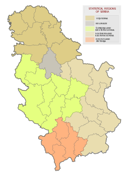
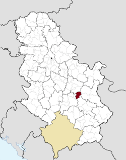 Location of the municipality of Ražanj within Serbia | |
| Coordinates: 43°40′N 21°33′E | |
| Country | |
| Region | Southern and Eastern Serbia |
| District | Nišava |
| Settlements | 23 |
| Government | |
| • Mayor | Dobrica Stojković (DSS) |
| Area | |
| • Municipality | 289 km2 (112 sq mi) |
| Elevation | 264 m (866 ft) |
| Population (2011 census)[2] | |
| • Municipality | 9,150 |
| Time zone | UTC+1 (CET) |
| • Summer (DST) | UTC+2 (CEST) |
| Postal code | 37215 |
| Area code | +381(0)37 |
| Car plates | NI |
| Website | www |
Etymology
In Serbian, "ražanj" means "stake". In Roman times it was called Cametas.
History
From 1929 to 1941, Ražanj was part of the Morava Banovina of the Kingdom of Yugoslavia.
Demographics
| Historical population | ||
|---|---|---|
| Year | Pop. | ±% p.a. |
| 1948 | 18,931 | — |
| 1953 | 19,623 | +0.72% |
| 1961 | 18,829 | −0.51% |
| 1971 | 17,113 | −0.95% |
| 1981 | 15,586 | −0.93% |
| 1991 | 13,582 | −1.37% |
| 2002 | 11,369 | −1.60% |
| 2011 | 9,150 | −2.38% |
| Source: [3] | ||
According to the last official census done in 2011, the municipality of Ražanj has 9,150 inhabitants.
Ethnic groups
The ethnic composition of the municipality:[4]
| Ethnic group | Population | % |
|---|---|---|
| Serbs | 8,815 | 96.34% |
| Roma | 195 | 2.13% |
| Macedonians | 11 | 0.12% |
| Croats | 3 | 0.03% |
| Others | 126 | 1.38% |
| Total | 9,150 |
Infrastructure
The main transport routes crossing the territories of the municipality of Ražanj are the Belgrade-Niš Highway as well as the Belgrade-Niš Railway. The Belgrade-Niš highway is a national key transport route and accordingly a vital transport route for the people living in the municipality of Ražanj. Two railroad stations are located within the area of the municipality (Braljina and Đunis). These are connected to the Serbian railroad network through the Belgrade-Niš railroad.
Economy
There are 62 companies currently present in the municipality of Ražanj. The majority of these are small firms, employing between 1 and 5 workers, while the rest are companies with 5 to 50 workers employed. The level of unemployment is higher in the municipality of Ražanj than in the other municipalities of the Nišava District. In addition, net earnings are about 26% lower than the national average of the Republic of Serbia. These numbers are partly explained by the fact that the municipality of Ražanj has a relatively old population (about 32% of the rural population are older than 60 years).
According to the National Bureau of Statistics, in 2007, 1,008 people were employed by state owned companies and institutions, 812 were employed by other organizations and 196 were self-employed.
- Agriculture
Agriculture is the biggest economy sector in the municipality and currently 5,594 people (49% of the total population) work in agriculture. The major part of the territory of the municipality of Ražanj is covered by arable areas, woodlands come second, fields and meadows come third and then fruit farms and vineyards. The agricultural land covers 59.6% (16,926 ha) of the total territory and is the central economy sector of the region. Main crops are maize, wheat, barley and oat. Arable areas cover 72.92% of the total agricultural area while the rest are covered by fruit farms (5.02%), vineyards (3.22%) and fields and meadows (16.91%). According to 2007 figures, the territory of the municipality Ražanj had a cattle population of about 4,000 heads, a swine population of 13,000 heads, a goat and sheep population of 3,500 animals, and a poultry population of about 65,000 hens.
Even if agriculture today is the primary economy sector of the municipality, it has great future potentials only by making it more market-oriented and efficient. On the territory of the municipality Razanj there are currently more than 1520 registered farms. According to the National Bureau of Statistics, in 2007, 96.60% of the land was privately owned while 2.85% was owned by the state.
- Economic figures
The following table gives a preview of total number of employed people per their core activity (as of 2017):[5]
| Activity | Total |
|---|---|
| Agriculture, forestry and fishing | 63 |
| Mining | - |
| Processing industry | 168 |
| Distribution of power, gas and water | 8 |
| Distribution of water and water waste management | 20 |
| Construction | 34 |
| Wholesale and retail, repair | 114 |
| Traffic, storage and communication | 40 |
| Hotels and restaurants | 16 |
| Media and telecommunications | 11 |
| Finance and insurance | 3 |
| Property stock and charter | 1 |
| Professional, scientific, innovative and technical activities | 32 |
| Administrative and other services | 7 |
| Administration and social assurance | 95 |
| Education | 107 |
| Healthcare and social work | 80 |
| Art, leisure and recreation | 3 |
| Other services | 18 |
| Total | 821 |
See also
- Nišava District
- Subdivisions of Serbia
References
- "Municipalities of Serbia, 2006". Statistical Office of Serbia. Retrieved 2010-11-28.
- "2011 Census of Population, Households and Dwellings in the Republic of Serbia: Comparative Overview of the Number of Population in 1948, 1953, 1961, 1971, 1981, 1991, 2002 and 2011, Data by settlements" (PDF). Statistical Office of Republic Of Serbia, Belgrade. 2014. ISBN 978-86-6161-109-4. Retrieved 2014-06-27.
- "2011 Census of Population, Households and Dwellings in the Republic of Serbia" (PDF). stat.gov.rs. Statistical Office of the Republic of Serbia. Retrieved 16 February 2018.
- "ETHNICITY Data by municipalities and cities" (PDF). stat.gov.rs. Statistical Office of Serbia. Retrieved 16 February 2018.
- "ОПШТИНЕ И РЕГИОНИ У РЕПУБЛИЦИ СРБИЈИ, 2018" (PDF). stat.gov.rs (in Serbian). Statistical Office of the Republic of Serbia. Retrieved 16 March 2019.
External links
| Wikimedia Commons has media related to Ražanj. |