Kasaragod
Kasaragod ([kɑːsɾɡoːɖ] (![]()
Kasaragod | |
|---|---|
City | |
| Nickname(s): Kaasrod | |
 Kasaragod Location of Kasaragod in Kerala  Kasaragod Kasaragod (India) | |
| Coordinates: 12.5°N 75.0°E | |
| Country | |
| State | Kerala |
| Regions | Tulu Nadu, North Malabar |
| District | Kasaragod |
| Nearest Airport(s) | Mangalore International Airport, Kannur International Airport |
| Area | |
| • City | 16.7 km2 (6.4 sq mi) |
| • Metro | 93.3 km2 (36.0 sq mi) |
| Elevation | 19 m (62 ft) |
| Population | |
| • Urban | 54,172 |
| Languages | |
| • Official | Malayalam, English, Tulu, Kannada, Konkani,[1] |
| Time zone | UTC+5:30 (IST) |
| PIN | 671121 |
| Telephone | 91–04994 |
| Vehicle registration | KL-14 |
| Website | kasargod |
Politics
The major political parties are CPI(M), CPI, Indian Union Muslim League, INC and BJP. North Kasaragod is dominated by BJP and IUML, and the south is dominated by CPI(M). N.A. Nellikkunnu is the present Member of Legislative Assembly, Kerala Legislature. Kasaragod assembly constituency is part of Kasaragod (Lok Sabha constituency). Indian National Congress [INC] member Rajmohan Unnithan is the present MP from Kasaragod [2019 Elections].[2]
Science and research
Kasaragod is home to the Central Plantation Crops Research Institute, originally established in 1916 as the Coconut Research Station. It is part of India's National Agricultural Research System under the Indian Council of Agricultural Research.[3] According to the Institute, Kerala "lies in the heart of the major coconut growing areas of the country." It is also home to the Indian Society for Plantation Crops, which publishes the Journal of Plantation Crops and holds symposiums on the subject.[4] The Central University of Kerala is also located in Kasargod.
Demographics
Malayalam , Kannada and Tulu is the most widely spoken language here.,[5] along with others like Beary, Konkani are also used by some people. Malayalam spoken here is influenced by Tulu and Kannada and vice versa.[6]
Religions in Kasaragod city
{{{1}}}
Image gallery
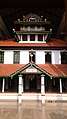 MalikDeenar Mosque is one of the oldest mosques in India
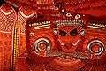 Theyyam is a popular ritual of worship in Kasargod
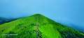 Ranipuram/Madathumala an attractive tourist destination at Kasargod
 Bekal fort is the top tourist spot in Kasaragod. Bekal fort and Bekal fort beach (Pallikkara beach) is one of the finest tourist destination in Kerala. There are luxurious hotels and beach resorts are surrounding Bekal Fort.
Climate
Kasaragod experiences a Tropical monsoon climate under the Köppen climate classification. It receives a generous 3,825 mm (150.6 in) of rain annually as per Weather Atlas.
| Climate data for Kasaragod, Kerala | |||||||||||||
|---|---|---|---|---|---|---|---|---|---|---|---|---|---|
| Month | Jan | Feb | Mar | Apr | May | Jun | Jul | Aug | Sep | Oct | Nov | Dec | Year |
| Average high °C (°F) | 31.4 (88.5) |
31.5 (88.7) |
32.2 (90.0) |
32.7 (90.9) |
32.2 (90.0) |
29.3 (84.7) |
28.2 (82.8) |
28.4 (83.1) |
28.8 (83.8) |
30.0 (86.0) |
31.0 (87.8) |
31.5 (88.7) |
30.6 (87.1) |
| Average low °C (°F) | 21.7 (71.1) |
22.8 (73.0) |
24.3 (75.7) |
25.9 (78.6) |
25.7 (78.3) |
23.9 (75.0) |
23.4 (74.1) |
23.6 (74.5) |
23.5 (74.3) |
23.8 (74.8) |
23.1 (73.6) |
22.0 (71.6) |
23.6 (74.6) |
| Average precipitation mm (inches) | 1 (0.0) |
1 (0.0) |
5 (0.2) |
55 (2.2) |
262 (10.3) |
1,002 (39.4) |
1,190 (46.9) |
647 (25.5) |
338 (13.3) |
229 (9.0) |
77 (3.0) |
18 (0.7) |
3,825 (150.5) |
| Source: Climate-Data.org[7] | |||||||||||||
See also
- Kasaragod East
- Kuloor
- List of educational institutions in Kasaragod District
- List of tourist attractions in Kasaragod
References
- "The Kerala Official Language (Legislation) Act, 1969" (PDF).
- "Kasaragod Parliament Constituency". Kerala. Election Commission of India. Archived from the original on 21 June 2008. Retrieved 18 October 2009.
- "About Institute". CPCRI.in. Central Plantation Crops Research Institute. Retrieved 25 January 2016.
The Coconut Research Station at Kasaragod in Kerala was initially established in 1916 by the then Government of Madras and subsequently it was taken over by the Indian Central Coconut Committee in 1948
- "Indian Society for Plantation Crops". indsocplantationcrops.in. Indian Society for Plantation Crops. Retrieved 25 January 2016.
- "District planning office, Kasaragod". Kerala State Planning Board. Retrieved 5 April 2020.
- A Sreedhara Menon (1 January 2007). A Survey Of Kerala History. DC Books. pp. 14–15. ISBN 978-81-264-1578-6.
- "CLIMATE: KASARAGOD", Climate-Data.org. Web: .
External links
| Wikimedia Commons has media related to Kasaragod. |

- "Places to Visit in Kasargod", Tripoto, retrieved 2 November 2014
- C.P.C.R.I
- CPCRI
- Official Website of the District Administration
- https://invest.kerala.gov.in/?district=kasaragodFile:..Kerala+Flag(INDIA).png+State+of+KeralaCapital:+ThiruvananthapuramDistricts+Thiruvananthapuram+KL-01+Kollam+KL-02+Pathanamthitta+KL-03+Alappuzha+KL-04+Kottayam+KL-05+Idukki+KL-06+Ernakulam+KL-07+Thrissur+KL-08+Palakkad+KL-09+Malappuram+KL-10+Kozhikode+KL-11+Wayanad+KL-12+Kannur+KL-13+Kasaragod+KL-14Topics+Arts+Culture+Demographics+Economy+Education+Film+Geography++Roads++Ports+History+Wildlife+Government+Tourism+SportsSymbolsBird+Great+hornbillAnimal+Indian+elephantTree+CoconutFlower+Golden+rainFish+KarimeenFruitJackfruitInsectPapilio+buddhaTaluks+Neyyattinkara+Kattakada+Thiruvananthapuram+Nedumangad+Chirayinkeezhu+Varkala+Kollam+Karunagappalli+Kunnathur+Kottarakkara+Punalur+Pathanapuram+Adoor+Konni+Kozhencherry+Ranni+Mallapally+Thiruvalla+Chengannur+Mavelikkara+Karthikappally+Ambalappuzha+Kuttanad+Cherthala+Changanassery+Kottayam+Kanjirappally+Meenachil+Vaikom+Peermade+Udumbanchola+Idukki+Thodupuzha+Devikulam+Kothamangalam+Muvattupuzha+Kunnathunad+Kanayannur+Kochi+Aluva+North+Paravur+Kodungallur+Chalakudy+Mukundapuram+Thrissur+Chavakkad+Thalapilly+Alathur+Chittur+Palakkad+Pattambi+Ottapalam+Mannarkkad+Perinthalmanna+Ponnani+Thirur+Tirurangadi+Eranad+Kondotty+Nilambur+Kozhikode+Thamarassery+Koyilandy+Vatakara+Vythiri+Sultan+Bathery+Mananthavady+Iritty+Thalassery+Kannur+Taliparamba+Hosdurg+Vellarikundu+Kasaragod+ManjeshwarMunicipal+Corporations+Thiruvananthapuram+Kochi+Kozhikode+Kollam+Thrissur+KannurMunicipalities+Adoor+Anthoor+Alappuzha+Aluva+Angamaly+Attingal+Chalakudy+Changanassery+Chavakkad+Chengannur+Cherthala+Chittur-Thathamangalam+Eloor+Guruvayur+Irinjalakuda+Iritty+Kalamassery+Kalpetta+Kanhangad+Karunagappalli+Kasaragod+Kayamkulam+Kodungallur+Kondotty+Kuthuparamba+Kothamangalam+Kottakkal+Kottarakkara+Kottayam+Koyilandy+Kunnamkulam+Malappuram+Manjeri+Maradu+Mattanur+Mavelikkara+Muvattupuzha+Nedumangad+Neyyattinkara+Nilambur+Nileshwaram+North+Paravur+Ottapalam+Pala+Palakkad+Panoor+Parappanangadi+Paravur+Pathanamthitta+Payyanur+Perinthalmanna+Perumbavoor+Ponnani+Punalur+Shoranur+Sreekandapuram+Tanur+Thalassery+Taliparamba+Thiruvalla+Thodupuzha+Thrikkakkara+Thrippunithura+Tirur+Tirurangadi+Valanchery+Vatakara+Vaikom+VarkalaOther+townsSouth+Parassala+Balaramapuram+Kattakada+Chirayinkeezhu+Kilimanoor+Parippally+Chathannoor+Kottiyam+Kundara+Neendakara+Chavara+Oachira+Sasthamkotta+Kunnathur+Anchal+Kadakkal+Pathanapuram+Thenmala+Kulathupuzha+Kozhencherry+Konni+Ranni+Mallapally+Kumbanad+Aranmula+Kulanada+Omallur+Vadasserikara+Parumala+Mannar+Charummoodu+Ambalappuzha+Mararikulam+Aroor+Kanjirappally+Erumely+Mundakayam+Vazhoor+Karukachal+Pampady+Puthuppally+Kuravilangad+Uzhavoor+Thalayolaparambu+KaduthuruthyCentral+Peermade+Vandiperiyar+Kumily+Rajakkad+Munnar+Devikulam+Adimali+Kolenchery+Puthencruz+Kunnathunad+Kalady+Malayattoor+Chottanikkara+Udayamperoor+Varappuzha+Sreemoolanagaram+Nedumbassery+Mala+Kodakara+Puthukkad+Manaloor+Pavaratty+Chelakkara+Vadakkencherry+Alathur+Nemmara+Puthunagaram+Malampuzha+Sreekrishnapuram+Lakkidi-Perur+ThrithalaNorth+Edappal+Tavanur++Angadipuram+Mankada+Kuttippuram+Karipur+Areekode+Wandoor+Vengara++Vallikkunnu++Olavanna+Kunnamangalam++Thamarassery++Thiruvambady++Kodencheri++Balussery++Perambra++Nadapuram++Kuttiady+Lakkidi+++Vythiri++Chundale+Meppadi+Kottappadi+Muttil++Padinharethara+Meenangadi++Panamaram++Pulpally++Peravoor+Dharmadom+Anjarakkandy+Muzhappilangad+Azhikode+Cherukunnu+Pappinisseri+Kalliasseri+Irikkur+Alakode+Trikaripur+Cheruvathur+Bekal+Udma+Vellarikundu+Parappa+Karadka+Kumbla+Mangalpady+Uppala+ManjeshwarHistorical+regions+Malabar+North+Malabar+South+Malabar+Cochin+Venad+Swarupam+(Kingdom+of+Quilon)+Travancore+Travancore-CochinFile:Flag+of+India.svg+
.png+State+of+KeralaCapital:+ThiruvananthapuramDistricts+Thiruvananthapuram+KL-01+Kollam+KL-02+Pathanamthitta+KL-03+Alappuzha+KL-04+Kottayam+KL-05+Idukki+KL-06+Ernakulam+KL-07+Thrissur+KL-08+Palakkad+KL-09+Malappuram+KL-10+Kozhikode+KL-11+Wayanad+KL-12+Kannur+KL-13+Kasaragod+KL-14Topics+Arts+Culture+Demographics+Economy+Education+Film+Geography++Roads++Ports+History+Wildlife+Government+Tourism+SportsSymbolsBird+Great+hornbillAnimal+Indian+elephantTree+CoconutFlower+Golden+rainFish+KarimeenFruitJackfruitInsectPapilio+buddhaTaluks+Neyyattinkara+Kattakada+Thiruvananthapuram+Nedumangad+Chirayinkeezhu+Varkala+Kollam+Karunagappalli+Kunnathur+Kottarakkara+Punalur+Pathanapuram+Adoor+Konni+Kozhencherry+Ranni+Mallapally+Thiruvalla+Chengannur+Mavelikkara+Karthikappally+Ambalappuzha+Kuttanad+Cherthala+Changanassery+Kottayam+Kanjirappally+Meenachil+Vaikom+Peermade+Udumbanchola+Idukki+Thodupuzha+Devikulam+Kothamangalam+Muvattupuzha+Kunnathunad+Kanayannur+Kochi+Aluva+North+Paravur+Kodungallur+Chalakudy+Mukundapuram+Thrissur+Chavakkad+Thalapilly+Alathur+Chittur+Palakkad+Pattambi+Ottapalam+Mannarkkad+Perinthalmanna+Ponnani+Thirur+Tirurangadi+Eranad+Kondotty+Nilambur+Kozhikode+Thamarassery+Koyilandy+Vatakara+Vythiri+Sultan+Bathery+Mananthavady+Iritty+Thalassery+Kannur+Taliparamba+Hosdurg+Vellarikundu+Kasaragod+ManjeshwarMunicipal+Corporations+Thiruvananthapuram+Kochi+Kozhikode+Kollam+Thrissur+KannurMunicipalities+Adoor+Anthoor+Alappuzha+Aluva+Angamaly+Attingal+Chalakudy+Changanassery+Chavakkad+Chengannur+Cherthala+Chittur-Thathamangalam+Eloor+Guruvayur+Irinjalakuda+Iritty+Kalamassery+Kalpetta+Kanhangad+Karunagappalli+Kasaragod+Kayamkulam+Kodungallur+Kondotty+Kuthuparamba+Kothamangalam+Kottakkal+Kottarakkara+Kottayam+Koyilandy+Kunnamkulam+Malappuram+Manjeri+Maradu+Mattanur+Mavelikkara+Muvattupuzha+Nedumangad+Neyyattinkara+Nilambur+Nileshwaram+North+Paravur+Ottapalam+Pala+Palakkad+Panoor+Parappanangadi+Paravur+Pathanamthitta+Payyanur+Perinthalmanna+Perumbavoor+Ponnani+Punalur+Shoranur+Sreekandapuram+Tanur+Thalassery+Taliparamba+Thiruvalla+Thodupuzha+Thrikkakkara+Thrippunithura+Tirur+Tirurangadi+Valanchery+Vatakara+Vaikom+VarkalaOther+townsSouth+Parassala+Balaramapuram+Kattakada+Chirayinkeezhu+Kilimanoor+Parippally+Chathannoor+Kottiyam+Kundara+Neendakara+Chavara+Oachira+Sasthamkotta+Kunnathur+Anchal+Kadakkal+Pathanapuram+Thenmala+Kulathupuzha+Kozhencherry+Konni+Ranni+Mallapally+Kumbanad+Aranmula+Kulanada+Omallur+Vadasserikara+Parumala+Mannar+Charummoodu+Ambalappuzha+Mararikulam+Aroor+Kanjirappally+Erumely+Mundakayam+Vazhoor+Karukachal+Pampady+Puthuppally+Kuravilangad+Uzhavoor+Thalayolaparambu+KaduthuruthyCentral+Peermade+Vandiperiyar+Kumily+Rajakkad+Munnar+Devikulam+Adimali+Kolenchery+Puthencruz+Kunnathunad+Kalady+Malayattoor+Chottanikkara+Udayamperoor+Varappuzha+Sreemoolanagaram+Nedumbassery+Mala+Kodakara+Puthukkad+Manaloor+Pavaratty+Chelakkara+Vadakkencherry+Alathur+Nemmara+Puthunagaram+Malampuzha+Sreekrishnapuram+Lakkidi-Perur+ThrithalaNorth+Edappal+Tavanur++Angadipuram+Mankada+Kuttippuram+Karipur+Areekode+Wandoor+Vengara++Vallikkunnu++Olavanna+Kunnamangalam++Thamarassery++Thiruvambady++Kodencheri++Balussery++Perambra++Nadapuram++Kuttiady+Lakkidi+++Vythiri++Chundale+Meppadi+Kottappadi+Muttil++Padinharethara+Meenangadi++Panamaram++Pulpally++Peravoor+Dharmadom+Anjarakkandy+Muzhappilangad+Azhikode+Cherukunnu+Pappinisseri+Kalliasseri+Irikkur+Alakode+Trikaripur+Cheruvathur+Bekal+Udma+Vellarikundu+Parappa+Karadka+Kumbla+Mangalpady+Uppala+ManjeshwarHistorical+regions+Malabar+North+Malabar+South+Malabar+Cochin+Venad+Swarupam+(Kingdom+of+Quilon)+Travancore+Travancore-CochinFile:Flag+of+India.svg+)