Fruitdale, California
Fruitdale is a census-designated place in Santa Clara County, California, United States. The population was 935 at the 2010 census.
Fruitdale | |
|---|---|
 Location in Santa Clara County and the state of California | |
 Fruitdale Location in the United States | |
| Coordinates: 37°18′46″N 121°56′9″W | |
| Country | |
| State | |
| County | Santa Clara |
| Area | |
| • Total | 0.269 sq mi (0.697 km2) |
| • Land | 0.269 sq mi (0.697 km2) |
| • Water | 0 sq mi (0 km2) 0% |
| Elevation | 144 ft (44 m) |
| Population (2010) | |
| • Total | 935 |
| • Density | 3,500/sq mi (1,300/km2) |
| Time zone | UTC-8 (PST) |
| • Summer (DST) | UTC-7 (PDT) |
| ZIP code | 95128 |
| Area codes | 408/669 |
| FIPS code | 06-27080 |
| GNIS feature ID | 1877235 |
Geography
Fruitdale is located at 37°18′46″N 121°56′9″W (37.312743, -121.935837).[2] It is bordered on the north, west, and east by San Jose, California, and on the south by Campbell, California.
According to the United States Census Bureau, the CDP has a total area of 0.3 square miles (0.78 km2), all of it land.
Demographics
| Historical population | |||
|---|---|---|---|
| Census | Pop. | %± | |
| U.S. Decennial Census[3] | |||
2010
At the 2010 census Fruitdale had a population of 935. The population density was 3,475.3 people per square mile (1,341.8/km²). The racial makeup of Fruitdale was 633 (67.7%) White, 31 (3.3%) African American, 11 (1.2%) Native American, 110 (11.8%) Asian, 4 (0.4%) Pacific Islander, 88 (9.4%) from other races, and 58 (6.2%) from two or more races. Hispanic or Latino of any race were 244 people (26.1%).[4]
The census reported that 861 people (92.1% of the population) lived in households, 26 (2.8%) lived in non-institutionalized group quarters, and 48 (5.1%) were institutionalized.
There were 361 households, 92 (25.5%) had children under the age of 18 living in them, 135 (37.4%) were opposite-sex married couples living together, 39 (10.8%) had a female householder with no husband present, 25 (6.9%) had a male householder with no wife present. There were 24 (6.6%) unmarried opposite-sex partnerships, and 5 (1.4%) same-sex married couples or partnerships. 118 households (32.7%) were one person and 29 (8.0%) had someone living alone who was 65 or older. The average household size was 2.39. There were 199 families (55.1% of households); the average family size was 3.11.
The age distribution was 171 people (18.3%) under the age of 18, 80 people (8.6%) aged 18 to 24, 271 people (29.0%) aged 25 to 44, 325 people (34.8%) aged 45 to 64, and 88 people (9.4%) who were 65 or older. The median age was 41.7 years. For every 100 females, there were 100.2 males. For every 100 females age 18 and over, there were 97.9 males.
There were 379 housing units at an average density of 1,408.7 per square mile, of the occupied units 195 (54.0%) were owner-occupied and 166 (46.0%) were rented.The homeowner vacancy rate was 1.0%; the rental vacancy rate was 2.9%. 507 people (54.2% of the population) lived in owner-occupied housing units and 354 people (37.9%) lived in rental housing units.
2000
At the 2000 census there were 895 people, 348 households, and 212 families in the CDP. The population density was 1,279.9/km² (3,364.9/mi²). There were 356 housing units at an average density of 509.1/km² (1,338.4/mi²). The racial makeup of the CDP was 76.54% White, 1.90% African American, 1.12% Native American, 5.47% Asian, 0.34% Pacific Islander, 7.15% from other races, and 7.49% from two or more races. Hispanic or Latino of any race were 16.76%.[5]
Of the 348 households 30.7% had children under the age of 18 living with them, 46.8% were married couples living together, 10.6% had a female householder with no husband present, and 38.8% were non-families. 28.2% of households were one person and 7.2% were one person aged 65 or older. The average household size was 2.49 and the average family size was 3.07.
The age distribution was 21.8% under the age of 18, 6.6% from 18 to 24, 39.1% from 25 to 44, 22.7% from 45 to 64, and 9.8% 65 or older. The median age was 37 years. For every 100 females, there were 95.4 males. For every 100 females age 18 and over, there were 94.4 males.
The median household income was $58,750 and the median family income was $94,224. Males had a median income of $45,781 versus $37,031 for females. The per capita income for the CDP was $30,724. About 3.0% of families and 6.6% of the population were below the poverty line, including 4.2% of those under age 18 and 25.0% of those age 65 or over.
Government
In the California State Legislature, Fruitdale is in the 15th Senate District, represented by Democrat Jim Beall, and in the 28th Assembly District, represented by Democrat Evan Low.[6]
In the United States House of Representatives, Fruitdale is in California's 18th congressional district, represented by Democrat Anna Eshoo.[7]
References
- "2010 Census U.S. Gazetteer Files – Places – California". United States Census Bureau.
- "US Gazetteer files: 2010, 2000, and 1990". United States Census Bureau. 2011-02-12. Retrieved 2011-04-23.
- "Census of Population and Housing". Census.gov. Retrieved June 4, 2016.
- "2010 Census Interactive Population Search: CA - Fruitdale CDP". U.S. Census Bureau. Archived from the original on July 15, 2014. Retrieved July 12, 2014.
- "U.S. Census website". United States Census Bureau. Retrieved 2008-01-31.
- "Statewide Database". UC Regents. Archived from the original on February 1, 2015. Retrieved December 7, 2014.
- "California's 18th Congressional District - Representatives & District Map". Civic Impulse, LLC. Retrieved March 14, 2013.
Municipalities and communities of Santa Clara County, California, United States | ||
|---|---|---|
| Cities | 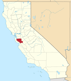 Santa Clara County map | |
| Towns | ||
| CDPs | ||
| Unincorporated communities | ||
| CCDs | ||
| Ghost towns | ||
| Bodies of water |
|  |
|---|---|---|
| Counties | ||
| Major cities | ||
| Cities and towns 100k–250k | ||
| Cities and towns 50k–99k | ||
| Cities and towns 25k–50k | ||
| Cities and towns 10k–25k |
| |
| Sub-regions | ||