Kullu district
Kullu is a district in Himachal Pradesh, India. The district lies in central Himachal and is famous for its tourist stations and Himalayan Treks connecting the trails with far remote regions between the adjacent districts of Lahaul and Spiti, Kinnaur , Mandi and Kangra districts which are bordered at North - North East , East , West and South Of Kullu respectively. The District is also a home to some of the Ancient settlements, Traditional Handloom and Apple Cultivation. It stretches from the Town of Rampur in the south to the Rohtang Pass in the North. The Main Kullu Valley which falls between the Pir Panjal Himalayas and Northern Edge Of The Dhauladhar or Bhangal Region lies at an elevation ranging from as less as 833 M to 3330 M from Aut Tunnel North Portal ( Some areas meshed in Mandi District Administrative Limits ) to Atal Tunnel South Portal On NH 3 and NH 505.

Kullu district | |
|---|---|
District of Himachal Pradesh | |
 Location of Kullu district in Himachal Pradesh | |
| Country | India |
| State | Himachal Pradesh |
| Headquarters | Kullu |
| Tehsils | Kullu, Nirmand, Banjar, Manali |
| Area | |
| • Total | 5,503 km2 (2,125 sq mi) |
| Population (2011) | |
| • Total | 437,903 |
| • Density | 80/km2 (210/sq mi) |
| • Urban | 7.92% |
| Demographics | |
| • Literacy | 63.45% |
| • Sex ratio | 105% |
| Time zone | UTC+05:30 (IST) |
| Website | http://hpkullu.nic.in/ |
The largest valley in the district is called the Kullu Valley, which is also known as the Valley of the Gods. There is also a town called Kullu which sits on the banks of the Beas River in the central part of the valley. From the confluence of the Parvati River with the River Beas, the Parvati Valley runs eastwards, through a steep-sided valley from the town of Bhuntar. Another important valley in the district is the Lug valley where the main forest contractors have been extracting timber from the forests for the last 150 years and continue to do so today.[1] Farther north lies the town of Manali.
The ancient seat of the kings of Kullu was at Naggar Castle, about 12 km north of the present town, and thought to have been built in the early 17th century by Raja Sidh Sing. Raja Jagat Singh (1637–72) moved the capital in the middle of the 17th century to its present position, and called it Sultanpur. The Royal compound consists of the "Rupi Palace, several temples, and a long narrow bazaar descending the hill."
The British took all of Kangra and Kullu from the Sikhs in 1846. It is still used as home by the royal descendants, but the more ancient Naggar Castle was sold to the British.
Since the onset of the most recent unrest in Kashmir, Manali and the Kullu Valley in general, have become important destinations for tourists escaping the summer heat of India.
In the eastern part of the district, the village of Manikaran contains Sikh and Hindu temples and popular hot springs. The Hidimba Devi Temple is at Manali. There are also many Sikh villages located close to Manikaran. To the northeast of Kullu Valley, lies the famous, Malana Valley.
| Wikimedia Commons has media related to Kullu district. |
Demographics
According to the 2011 census, the district had a population of 437,903.[2]:24 At this census, 44% of the population in the district declared Kullui as their first language, 23% opted for Pahari, 10% chose the Siraji variety of Kashmiri, 7.8% – Hindi, 3.2% – Mandeali, 2.5% – Nepali, 2.3% – Lahauli, 0.92% – Punjabi, 0.87% – Kangri, 0.84% – Kinnauri, and 0.41% – Tibetan.[3]
| Historical population | ||
|---|---|---|
| Year | Pop. | ±% p.a. |
| 1901 | 119,585 | — |
| 1911 | 124,803 | +0.43% |
| 1921 | 122,027 | −0.22% |
| 1931 | 131,425 | +0.74% |
| 1941 | 137,202 | +0.43% |
| 1951 | 145,688 | +0.60% |
| 1961 | 152,925 | +0.49% |
| 1971 | 192,371 | +2.32% |
| 1981 | 238,734 | +2.18% |
| 1991 | 302,432 | +2.39% |
| 2001 | 381,571 | +2.35% |
| 2011 | 437,903 | +1.39% |
| source:[4] | ||
General Information
- Sub divisions in Kullu: Kullu, Anni, Banjar and Manali.
- Tehsils in Kullu: Kullu, Nirmand, Banjar, Manali, Bhuntar and Anni.
- Sub-Tehsils in Kullu: Sainj and Nithar .
Kullu District is also a Home to The Great Himalayan National Park a UNESCO world heritage site and can be approached via NH 305 in Tirthan Valley and some of the prominent Hill stations which are Offbeat in General . Jalori Pass which is Located at a Sea Level Height Of 3132 M is also a called Old Britisher Route Connecting the district with The state Capital Shimla
Further information can be had on http://hpkullu.gov.in, the Official Website of District Kullu.
Gallery
 Sikh pilgrims cheering on truck to Manikaran
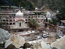 Manikaran, Kullu District, 2004
 Shiva shrine, Kullu, 2004
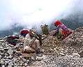 Road workers crushing rocks, Kullu, 2004
 Steam from Manikaran baths, 2004
 2 friends - a Sikh & a Gaddi, Manikaran, 2004
 Pilgrims being fed at Sikh gurdwara, Manikaran, 2004.
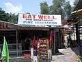 Roadside restaurant, Kullu, 2004
 Raja Rupi Kulu Palace, 2004
See also
- Lug Valley
- Upper Valley
- Parvati Valley
- Rupi Valley
- Tirthan Valley
See notes
- "History of Ropeways in Kullu". Archived from the original on 23 May 2003. Retrieved 24 December 2006.
- District census handbook : Kullu (PDF) (Report). 2011. Retrieved 6 October 2019.
- "C-16 Population By Mother Tongue - Himachal Pradesh". censusindia.gov.in. Retrieved 6 October 2019.
- Decadal Variation In Population Since 1901
Further reading
Chetwode, Penelope. 1972. Kullu: The End of the Habitable World. John Murray, London. Reprint: Time Books International, New Delhi. ISBN 81-85113-20-3
External links
- DISTRICT PROFILE
- CULTURAL & TOURISM HERITAGE OF THE DISTRICT
- Birds, Butterflies, Landscapes etc. of Kullu District
- Birds of Kullu District
- Butterflies of Kullu District
- Landscapes of Kullu District
Places adjacent to Kullu district | |
|---|---|
| Topics | |||||||
|---|---|---|---|---|---|---|---|
| History |
| ||||||
| Culture | |||||||
| Jurisdiction | |||||||
| Districts and divisions |
| ||||||
| Major cities | |||||||
| Economy | |||||||
| Geography | |||||||
| Images and Others | |||||||
| Lakes | 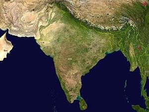 | |
|---|---|---|
| Rivers | ||
| Districts | ||
| Other |
| |