Akhnoor
Akhnoor is an archeological site and Municipal Committee in Jammu district in the union territory of Jammu and Kashmir, India. It is located at a distance of 28 km from Jammu, in the foothills of the Himalayas. The town is located on the banks of the Chenab River. The Akhnoor is divided into three Administrative Sub-Divisions - Akhnoor, Chowki Choura & Khour; Seven Tehsils - Akhnoor Khaas, Chowki Choura, Maira Mandrian, Jourian, Kharah Balli, Khour & Pargwal. Akhnoor is also divided into three Education Zones of Akhnoor, Khour & Chowki Choura.
Akhnoor | |
|---|---|
city | |
 | |
 Akhnoor Location in Jammu and Kashmir  Akhnoor Akhnoor (India) | |
| Coordinates: 32.87°N 74.73°E | |
| Country | |
| Union territory | Jammu and Kashmir |
| District | Jammu |
| Elevation | 301 m (988 ft) |
| Population (2011) | |
| • Total | 11,225 |
| Languages | |
| • Official | Urdu |
| Languages | |
| • Secondary official | Dogri |
| Time zone | UTC+5:30 (IST) |
| PIN | 181201 |
| Telephone code | 91 1924 |
| Website | www |
History
The place is believed to be the ancient city of Virat Nagar mentioned in the Mahabharata[1][2] however, Bairat, a town in northern Jaipur district of Rajasthan is more established as the ancient Virat Nagar.[3][4] The place is one of the most important historical sites in Jammu and Kashmir. Excavations by the Archaeological Survey of India have established the fact that Akhnoor was one of the last bastion of the Harappan Civilization and Manda, Akhnoor is the northern most site of the Harappan Civilisation. Terracotta figures and other anthropological objects belonging to the later Harappan period have been found during the excavations. Beyond Akhnoor, towards the upper hilly area that joins Sivalik Hills, there has been no trace of any object that could show that Harappans moved any further beyond this town.
Excavations at Ambaran-Pamberwan sites have proved that the place was a prominent abode of Buddhism during the Kushan period and Gupta period. Apart from an ancient an eight-spoke Stupa (a mound-like structure containing Buddhist relics, made of high quality baked bricks and surrounded by stone pathways, meditation cells and rooms),[5] life sized Terracotta busts of Buddha and coins belonging to those periods were also excavated from the sites.[6] The 14th Dalai Lama visited the place in August, 2012. Buddhist relics from the Pre-Kushan reign and silver caskets, gold and silver leaves, pearls, corals and three copper coins from the Gupta period are reported to be found.[7][8] The location of the Stupas is such that it lies on the ancient routes from Pataliputra, in present-day Patna, Bihar, in India to Taxila now in Punjab Province, Pakistan.
Among other find of historical importance that indicates the place inhabited by people pre-dominantly belonging to Hinduism is the green coloured Trimurti idol made up of a single stone at Ambarran Village.
Etymology
The town is believed to have been named Akhnoor by Mughal Emperor Jahangir who once visited the area and the fort on the advice of a saint when his eyes got infected while returning from Kashmir. Amazingly, Jahangir's eyes were fully cured by the fresh air of the town blowing over the Chenab. He called the town Aankho-ka-Noor (light of the eyes) and since then the place came to be known Akhnoor.[9] However a contrasting narrative as copied from the official site of Akhnoor goes like this:
... it came to be known as Akhnoor during the Mughal reign. The reason behind this is that the Mughal emperor's wife had vision problem in her eyes and she was prescribed to wash her eyes with the holy water of Chenab using some ayurvedic medicines by a local Hindu priest. The queen strictly followed the prescription and her vision was restored. Hence the city was named Akhnoor as in Urdu the word 'noor' means vision/glow/shine and the word 'aankh' means the eye.
— Akhnoor Sub-Division Administration[10]
Geography
Akhnoor is located at 32.87°N 74.73°E.[11] It has an average elevation of 301 metres (988 ft). Akhnoor is located at the right bank of the mighty Chenab. Chenab enters plains at Kathar (Khadhandhara Valley)[12] in Maira Mandrian tehsil of Akhnoor. On the north and east, the Shiwaliks, Kali Dhar and Trikuta range surround it. Akhnoor lies on National Highway 144A that runs between Jammu and Poonch, about 28 km away from Jammu. It connects with Rajouri district on the north, Reasi district on the east and the Chamb tehsil (Pakistan-administered Kashmir) on the west. It has humid subtropical climate.
Demographics
As of 2011 India census,[13] Akhnoor had a population of 11,225. Akhnoor is governed by Municipal Committee of Akhnoor having 13 wards. Males constitute 54% of the population and females 46%. Akhnoor has an average literacy rate of 78%, higher than the national average of 74%; with 56% of the males and 47% of females literate.
The languages spoken are Dogri followed by Punjabi, Urdu, Hindi and English.
Religion
Hindu 92.37%, Muslim 2.70%, Christian 2.38%,[14]
Tourism
Some of the main tourist attractions are:
- Sumah Devta: A Classical Dogra Shrine
- Jia Pota Ghat
- Akhnoor and Indus Valley Civilization
- The historical sites of Ambaran - Akhnoor
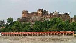
- Akhnoor fort
References
- Official Web Site of Akhnoor Sub-Division (J&K)
- Akhnoor: Caught in a time warp - The Hindu
- A Tryst with History at Viratnagar
- Kapasan Mata
- Dalai Lama to visit Kushan period monastry [sic] excavated in Kashmir | Hill Post
- Dalai Lama to visit Ambaran next month - News Oneindia
- Dalai Lama Visits Ancient Buddhist Sites in Jammu : Himsatta
- "Archived copy". Archived from the original on 8 March 2014. Retrieved 27 February 2014.CS1 maint: archived copy as title (link)
- The Tribune...Saturday Plus Head
- Akhnoor Tourism
- Falling Rain Genomics, Inc - Akhnoor
- Jamwal, Nagendra Singh (12 May 2013). "A vale behind the veil". Daily Excelsior. Retrieved 18 April 2018.
- "Census of India 2001: Data from the 2001 Census, including cities, villages and towns (Provisional)". Census Commission of India. Archived from the original on 16 June 2004. Retrieved 1 November 2008.
- http://www.census2011.co.in
External links
| Wikimedia Commons has media related to Akhnoor. |